This is a Guest Post by Stu Donovan
Imagine you are a policy-maker in a city, such as Auckland, which faces growing travel demands and persistent socioeconomic inequality: How might you apply your transport budget to tackle both problems at once?
In this recent paper published in the journal “Transport Policy”, my co-author and I consider this question. From a policy perspective, major transport investments would ideally be efficient—in that their benefits exceed their costs— and equitable—in that they disproportionately favour the less well-off.
To answer the second question, several studies propose accessibility-related “justice tests”. Our research extends this literature in two ways: First, we test whether a project is “just” using the correlation between the change in accessibility and socioeconomic outcomes. Second, we apply our test to a case study of Auckland’s “City Rail Link” (CRL).
Data does indeed show that deprivation is concentrated in certain parts of Auckland, as illustrated below (NB: Higher percentile indicates higher deprivation).
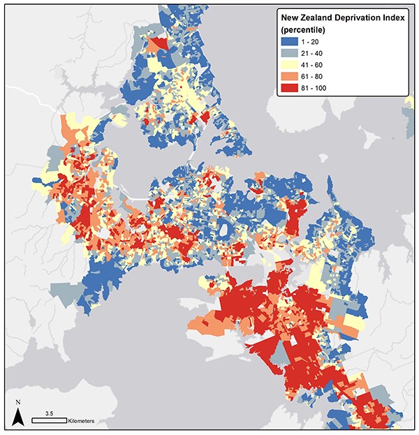
Figure 1: New Zealand Deprivation percentile scores (NZDep).
In our paper, we model the effects of the CRL using Auckland’s “General Transit Feed Specification” (GTFS feed), as shown below. A GTFS feed consists of standardised text files containing information on the PT network, such as stop locations, route alignments, and schedules. GTFS feeds are now available for PT networks in more than 500 cities worldwide, providing a rich and standardised way to represent PT networks.
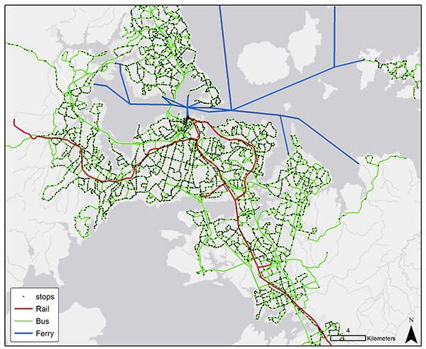
Figure 2: Auckland’s GTFS feed. Bus, rail, and ferry routes in green, red, and blue respectively; black circles denote stops and stations. (Auckland Transport).
We edited Auckland’s GTFS feed to model the effects of the CRL. We complement the GTFS feed with pedestrian networks sourced from Open Street Maps (OSM), from which we calculate walking times to access PT services. Finally, we developed a routing tool in Python to calculate PT travel-times and accessibility across Auckland, accounting for time spent walking, waiting, and in-vehicle.
Using this tool, we can then calculate the change in accessibility to jobs across Auckland when assuming a 45-minute maximum travel-time, for example. We find the CRL increases accessibility in the west, east, and south of Auckland, which broadly aligns with the areas of high deprivation illustrated above.
One might expect, then, a positive correlation between accessibility and socioeconomic deprivation, and so it proves: In almost every scenario that we test, we find a positive correlation coefficient between the change in accessibility caused by the CRL and prevailing socioeconomic deprivation. We conclude the CRL is a relatively “just” project.
To me, this was a somewhat fascinating outcome. In the debate about the CRL, some claimed the benefits would fall to the city centre. While it is true the CRL is situated in the city centre, we find that the bulk of the benefits fall to Auckland’s most deprived suburbs. In this case, what is good for the city is good for suburbs.
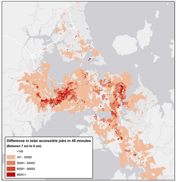
Figure 3: Change in accessibility from CRL (45-minute travel-time).
We are the first to admit that our proposed test is not ideal.
Using the correlation coefficient as a criterion for justice tests may be unreliable, for example, in the presence of outliers and/or non-linear associations. In this specific case study, scatter plots of the underlying data points indicate neither of these two statistical issues were present. Other methodological issues, such as dynamic effects where households change location in response to changes in accessibility, are also omitted.
Some may also quibble whether a single justice test can help understand the complex and diverse effects of PT investments. We hedge our bets on this front: On the one hand, the literature identifies a gap between policy and practice in relation to justice tests. In this context, a single, simple, and stable justice test may be better than nothing.
On the other hand, we do not believe there exists one justice test to “rule them all”; careful application and interpretation is, as always, needed. And potential transport investments that do not pass our proposed test may nonetheless be worthy of funding. Determining that a project is just, using this test or any measure, does not imply that it is worthwhile; the latter is a distinct, equally important, question.
Acknowledgements: This paper was co-authored with Saeid Adli.
Disclosure: The author works as a transport consultant for this firm

 Processing...
Nice work. It’s good to have a more objective way of testing what a lot of us guessed would be the case. Would be interesting to see the same method applied to the likes of City to Mangere LR, Northwest LR and the Eastern Busway.
The business cases for all three of those projects include a very similar measure of the increase in access to employment, if not the justice test aspect.
Measuring accessibility is a half-hearted step in the right direction.
But policy settings wax lyrical about the need for investment to address deprivation. So it confuzzles me why we wouldn’t consider the relationship between accessibility and deprivation.
And once you’ve calculated accessibility you’ve done 90% of the work!
With access one of the two high priorities of the GPS, what are the practicalities of including this sort of analysis in the IAF/EEM?
Let me qualify that, both accessibility and deprivation are measured and considered in each of those business cases, just not as a single integrated measure.
Having said that, when they put the accessibility map and figures right next to the deprivation map and figures you can see the qualitative outcomes very readily: for example, its pretty obvious that a rail line through Mangere vastly improves access to jobs for a highly deprived area.
Gotcha!
Nice work Stu and Saeid, always good to see attempts to run objective tests of project outcomes. Even, or especially, of ones that appear intuitively obvious: will the CRL significantly improve access to employment and education for many people? Yes. Are many of those people currently those in most need of it? Yes.
Did the model include bus and bike rail station catchment, or just walk-up?
It must include at least bus access judging by those outputs.
yes we include existing bus access. Note that we don’t, however, optimise the bus network in response to the CRL.
So there’s definitely some more accessibility juice to be squeezed out of the CRL watermelon compared to what we analyse here.
Thanks Patrick!
The model includes walk-up access to stops for all PT modes (bus rail and ferry).
For some this result may have been obvious. For us it wasn’t really that clear what we would find.
But it really was a clear result: benefits of CRL tend to favour the less well-off.
This is an interesting post. Confirmed that the CRL will mostly benefit the western line even to the outlier Swanson area. I assume those benefits for Eastern and Southern lines are because the CRL opens up more of CBD and onwards to Mt Eden etc.
The deprivation index mapped over Auckland sure answers why the SW badly needs LR
Also the Avondale Southdown HR line looks ideally placed over western isthmus deprived areas.
Good post, thanks, more please.
The Eastern and Southern lines also benefit from the ability to run more frequent services and expresses after the CRL opens.
Glad you enjoyed it!
Yes, access to the city centre is one source of benefits. But also higher frequencies on all lines enabled by the CRL.
Note also that rail lines run two-ways (I don’t mean that to be facetious; it is–in my experience–a truism that is frequently overlooked).
So one of the benefits of the CRL to the Eastern line is that the frequency it provides enables people to access more jobs to the south too, for example around Manukau.
“Also the Avondale Southdown HR line looks ideally placed over western isthmus deprived areas.”
Is that still a likely line in future?
No
I wouldn’t write off the Avondale to Southdown line as KR have not given up the right of way and ownership of the route. There was also future proofing for the route when the motorway through to the waterview tunnels was built. There is also the ongoing likely development of the NAL for freight although volumes are uncertain until Northport is further developed and the currently constructing rail line between NAL and northport is completed. Further future relocation of PoA or its traffic is also in the mix.
The suggestion to replace this with a mt Roskill to New Lynn LR doesnt seem to have gained much support either. The AtoS HR line could also provide a passenger service across the lower isthmus and perhaps become an outer isthmus circle line while still accomodating freight transfers from NAL to existing inland ports.
Interesting but perhaps counterintuitive point with the Marsden Link is that it is likely to reverse current freight flow on the NAL from south to north… ie logs and milk powder will be able to leave nz via Northport rather than trundle slowly through AKL to the crowded and more distant docks of Akl or Tau…
Also, say if Northport becomes a bigger import port, because Avondale-Westfield doesn’t get passed Avondale or New Lynn bottlenecks it would do little on its own to increase freight volumes on the line during day, despite costing a fortune, it is more likely money would first go on a rail freight depot in the NW, consolidating goods during the day there, to fire through the Western Line over night…
Be able to get a lot of long freight runs through to the south AKL depots before the morning Metro startup every night…
I’d add that the Mt Roskill spur, which I liked as an inner turnback – and even potential for express flighting – hasn’t been heard of for a while.
It would connect with the Light Rail now of course – which seems to have replaced it (and will do on the Roskill-Onehunga right of way) – but it would add really good connectivity to the Western line from Onehunga, Airport and Mangere. Plus maybe push more TOD.
Think network!
Great post – thanks Stu & Saeid. You said, “We complement the GTFS feed with pedestrian networks…”. I’m wondering how much greater benefit could be achieved if cycle networks could be included as well.
There have been plenty of discussions on this forum about the potential of cycles to greatly increase the catchment of a PT network, and it’s particularly relevant in areas with a high deprivation index due to the low capex and opex costs of riding a bike.
Admittedly we already have a footpath network while cycle networks are either sparse or force cyclists onto a hostile roadway. But with extra cycling investment in safe cycle paths and bike parking which I’m assuming would carry a decent BCR in their own right, I’m also suggesting a benefit multiplier effect when combined with PT/CRL analyses. A virtuous circle if you will of PT combining with active modes of all types to increase the efficiency of the entire transport network.
Cheers – Steve
Hi Steve,
Thanks and good comment. In the paper we discuss how you might deal with multi-modal access. Basic idea is calculate accessibility for all access modes (walk, cycle, car). Then you can weight them by access mode share and sum them up.
Btw, my understanding is that OSM data has cycle only links too, so it might pick up travel-time benefits of cycling investment (just not the wider sense of safety/ease that comes from better infra).
Also, I’d be interested to know how cycling as first leg would affect these results if 30 km/hr zones were implemented everywhere (except where separated cycling infra is provided.)
note that we only model travel-time. So assuming the 30 khr zones don’t affect cycle travel-times then they wouldn’t affect cycle access.
They may, however, reduce car access. That said, I don’t think this is the right kind of tool to model the effects of such policies, because we use a rather narrow (time-based) definition of accessibility.
You could look at this from another angle. Assuming most of the accessible jobs are in the CBD, I wonder how many people from deprived areas have skills that are useful for those jobs? Maybe this is a bad outcome?
I think the more pertinent question is how useful are most CBD workers’ jobs?
I think the more pertinent question is what do you mean by useful?
Bad in what way? Wouldn’t the worst case scenario be, in the event of a job-skill mismatch, that an extra job provides no benefit to someone? I struggle to understand how an increase in accessibility could be negative, unless you’re perhaps alluding to gentrification?
One other aspect worth keeping in mind: jobs are not just a measure of employment. They are also positively correlated with retail / medical / tertiarty education / cultural services. Hence by considering access to jobs, we are using the latter as a proxy for lots of useful things. Not ideal, but better than just employment in of itself.
Interesting Stu. But surely the final impact after dynamic effects is all that matters. If CRL benefits some slumlords who can throw out low income tenants and replace them with higher paying yuppies it tum pushing the poorest people to even more remote locations then CRL might not be ‘just’.
Addressing slumlords and other lords of land with multiple holdings will require some governmental action in the area of capital gains and putting limitations on how much property a person is entitled to own, which realistically may never happen. The CRL will provide in the very least some environmental benefits, which admittedly are probably more the preserve of the less deprived, but just for that fact it is more than worth it. If another benefit is some degree of socio-economic equalisation, that increases its value incalculably. Governments may need to re-find socialism to ensure this outcome, but in the interim, a more efficient and accessible public transport network will have to do.
I’m not sure it really matters who owns the houses, if they go up in value they will inevitably be occupied by more well-off people, even if not immediately. A few poor people who happen to own a house in the area being gentrified might get a windfall benefit but that’s not really solving anything.
I don’t see a problem with people owning multiple houses, it’s common in places with much better regulated rental markets as well. Not everyone has the means or interest in owning a home. The issue here is the lack of protection for tenants and a market that encourages people to invest for speculative reasons rather than long term rental returns.
I think when it comes to where the benefits accrue land ownership is the only thing that matters. Land is a weird asset. Benefits crystallise in higher land prices. I think that has been shown in urban studies and even in studies that show increased produce prices result in higher farm prices and little or no increase in profits for sharecroppers in the US.
In this case if CRL puts up land values then anyone who desires the benefit will have to pay to use it. It is why a just approach tends to improve accessibility overall rather than on a couple of key routes.
As a total aside some people have suggested that a cleaner way to assess benefits of transport projects is simply to estimate future land values. It avoids needing travel times costs, vehicle operating costs, traffic models or any of that stuff.
You can’t justify inaccessibility on the basis that providing access will bring gentrification. All you can do is keep increasing accessibility.
Gentrification is a funny one. You would think that for every suburb that gets gentrified, there must be a suburb that gets de-gentrified. But I can’t think of any de-gentrifying suburbs (happy to be proven wrong).
If everything gets gentrified, surely that is a good thing (eliminating poverty etc).
Manurewa has definitely de-gentrified, it was a popular area for young middle-class families when it was first developed. As it became clear that the commute wasn’t going to be quick for long many moved out.
Fair enough. But is this recent or a few decades ago? And I wonder if it is starting to be considered close enough to slowly become gentrified again?
I can certainly think of a number of suburbs that have been gentrified to some extent in the last 10 years: is Manurewa the only causality? Maybe Papakura too?
Grey Lynn has gone thru these cycles.
I think miffy has it right. Gentrification will surely result if access to public transport is not provided on an equal basis.
If some areas are privileged with much better public transport than others, then the poor will inevitably be forced out of the privileged areas, losing their communities and ending up with higher vehicle-related costs and longer travel distances.
To me the answer is not just to keep increasing accessibility, but also to do so in a fair way that does not create inequalities in public transport provision. We have failed badly in this regard recently but that doesn’t mean we have to keep failing.
The problem of gentrification is one reason why it is great to have a transport and housing minister together.
If access is upgraded (including by motorway) but dwelling supply is not, then current owners get a windfall.
This is no argument to not improve anything (the cynic’s line). But rather a call to add housing for those outside of property ownership now.
That is the aim of the current gov’s housing policy with HNZ, KiwiBuild, and the HUD; these are working directly and consciously with transport investment; TODs.
Both are necessary for equity.
We need to look at how Vienna deals with this. Maintaining social and state housing is important.
And the Superblocks in Barcelona video showed they consciously kept the areas as social housing because they knew the pedestrianisation ran the risk of gentrification, which would push out the very people who had worked for change.
Yes, dynamic effects are important. I wouldn’t say they’re the only thing that matters though.
First, the land price response and associated gentrification could take years or even decades to fully materialise. In which time a lot of benefit can be gained.
Second, and perhaps more importantly, this is where social housing can complement transport policy. If you have or add social housing in these areas, then you can insulate low socioeconomic households from gentrification. Not saying that’s necessarily effective policy, just that it can be done if necessary.
Really interesting research, thanks Stu and Saeid.
“pedestrian networks sourced from Open Street Maps (OSM)” – Is this what Journey Planner uses too, for its pedestrian legs of journeys? I’m just wondering if this is the source of the directions to walk in unsuitable places, such as across the Greenlane Roundabout, and through service stations?
Hi Heidi,
I believe (although am not sure) that AT’s journey planner uses it’s own pedestrian network, which may in part be based on OSM.
None of these tools are perfect, unfortunately. That said, OSM is amazingly rich, freely-available, and open-source data. So I’ll take it!
Sorry to sound negative, but there are some serious reality checks needed with this analysis.
Firstly the most deprived areas in greater Auckland are in south Auckland, in suburbs such as Otara, where one would have to get a bus to Papatoetoe to catch a southern line train into the city. Where is the positive impact of CRL in this equation? Why would people from Otara, East tamaki, Flatbush Ormiston Botany etc go past the southern motorway to catch a train that takes over 40 minutes to travel into the city at peak time or whenever, compared with 20 minutes on the motorway during non peak hours. The peak hour trip is slower.
Secondly any one from the southern line going to Mt Eden, currently changes at Newmarket, what will change in this equation with CRL? anything?
Thirdly the assumption that CRL will allow more trains on the southern line, is not necessarily true.
The current 20 minute interval between trains may be cut to say 10 minutes, yeah right!,
This will require a huge increase in rolling stock (trains & carriages) and it also requires serious investment in eliminating level crossings in South Auckland. I believe there are circa 12 such road crossings.
Given that it will cost circa $30 million + to either provide an over bridge or tunnel for each crossing, who picks up that bill? Imagine the east west road blockages and anger that will ensue if a busy crossing say in Takanini at Walters road (there are 2 level crossings in Takinini) is closed every 10 minutes to allow a near empty mid day time train to pass north or south?
It was this issue that set the 20 minute interval when electric trains were introduced.
Your analysi might work if there was unlimited capital to pay for the additional capital works necessary to support a more efficient service but that does not exist, and will never be allowed by our socialist government.
Alan
So you’re arguing that higher train frequency will create public demand for an already much-needed level crossing removal programme? That’s great news! I look forward to this happening after CRL opens.
“Your analysi might work if there was unlimited capital to pay for the additional capital works necessary to support a more efficient service”
What are you suggesting we invest in, Alan?
Heidi
The current Govt is restricting capital investment. as are the commercial Banks.
The Govt is running a large budget surplus, They have spent heavily on Education and Wage settlements for the public sector.
You may not realise they have stopped all PPP schemes (public private partnerships)
A good example of a PPP scheme are the 2 new schools at Hobsonville Point.
The Govt is also restricting what ACC (accident corporation) can invest in. It has up to $3 BILLION available to invest in DHB hospital buildings, but recently declined Counties Manakau District Health board funing request to basically rebuild Middlemore hospital.
Why are they doing this? i cannot answer that question.
alan
We really do need a post about education some time. I personally like schools where the teaching staff have to be registered teachers.
But maybe there’s an answer to your question in the amount we are subsidising the driving mode. The EU has found it is 500 billion Euros per year.
Some radical rethinking is needed to stop this subsidy so we can put it into investments that reap rewards. The EU found, for example, “Due to positive health effects, cycling is an external benefit worth €24 billion per year and walking €66 billion per year.”
That sounds interesting Heidi, can you please share a link to that EU report?
I’ll give you the link to the tweet from one of the authors as it has a link in it to a free download: https://twitter.com/stefangossling/status/1088575145277513728?s=12
You’re wrong on a couple of counts:
1) There is already enough rolling stock to run 10-min frequencies, they do this during the peak and it’s the same trains they use all day.
2) The reason for the 20 min frequencies is due to network constraints between Wiri and Westfield. It is absurd to suggest trains are allowed to run every 10 mins during peak when road traffic is busier but not off-peak due to concerns around traffic delays.
Jezza
There may be enough rolling stock on hand to increase train frequency to 10 minutes but not if they extend all trains to 6 or 9 carriages. The new stock on order will not solve this issue either.
The so called network constraints between Wiri and Westfield are no different from the rest of the southern line, There are 2 tracks all the way into the city.
It is still a 55 minute journey from Papakura to Britomart.
What Kiwirail want is a third track to run additional freight and express trains. They call this a “network constraint”. Bear in mind also Ports of Auckland want exclusive use of the southern line between 10pm and 6am seven days a week for the forseeable future to move containers
ALAN
The new stock order will allow all trains to be 6-car, it will be a long time before off-peak trains need to be longer than 6-cars.
There are greater network constraints between Westfield and Wiri because two lines share this track and it is also the busiest freight section in the country with Tauranga to Metroport and Ports of Auckland to Wiri services overlapping.
This constraint means Kiwirail will only allow 10 minute services on the Southern and Eastern lines during two relatively short peak windows each day. The third main allows AT to run 10 min frequencies all day without it impacting on freight services.
“so called network constraints between Wiri and Westfield are no different from the rest of the southern line”
Conveniently forgetting that this section gets both Southern & Eastern Line services, so double the frequency of the rest of the Southern Line…
Also (very conveniently) ignoring that the Eastern Line also runs from Westfield Junction to the City, meaning there are four tracks north as far as Quay Park Junction. (And that a significant number of freighters terminate at Westfield/Southdown.)
I think the main issue is the 45 minute travelling time. Many of the wealthier parts of Auckland are already within that travel time to the CBD so of course the benefit appears to be going to the outer areas that aren’t. But someone in Mt Albert that currently has a 30 minute travel time and will have a 20 minute travel time definitely gets a big benefit too.
Good point.
Actually the results are robust to different time cut-offs (20-60mins) and also a distance decay function. Details are in the paper (appreciate it’s paywalled).
Alan new trains are on order, are being built now.
Bus to train is already proving effective at good interchange stations like Panmure and Otahuhu. You are essentially making the case to give those buses high priority and frequency. I agree.
The 3rd main (already funded) will absolutely enable higher frequency on the Southern and eastern lines.
Level crossings are really a road issue, that they hold up traffic is not particularly a problem for train users. However it’s best they are upgraded, there are funds that can be used to address this. Certainly more high quality interchange stations are needed to better link to those further from the spine, especially south.
It is a multi-year project to make up for many decades of neglect. It is fundible because the massive urban motorway age is done. Many billions have been redirected in ATAP to Rapid Transit from new motorways. The Eastern Busway, Northern Busway extension, Airport to Botany, both Light Rail lines, and continual upgrades to the rail network are all in the $28b 10 year ATAP plan. CRL, 3rd main, Puke electrification, additional trains.
AT is sorting bus corridors to significantly improve the next level down; greater efficiency and speed on arterials.
We’re doing this.
Does anyone honestly believe that whatever shade of political party is in power when CRL is finished that they will then pay out 80% of the approx $300 million needed to eliminate these level crossings. it is only the labour party that could do this for its “heartland” but will they be in power in 2024?
Do you seriously believe we are going to spend $4 billion on CRL and not increase frequencies? Frequencies will increase especially during peak times when the impact on level crossings is at its greatest. There will be two choices, put up with the increased road congestion or spend the money, I think a government of either colour would find it a relatively easy choice to spend the money.
Yes. This is hardly a contentious programme, they will be upgraded gradually, like the stations. It’s a technical more than a political issue. Anyway you may remember the National Party signed up for the CRL, didn’t discard electrification, considered it, but went ahead on the evidence… there’s a lot of this sort of gloom in the comments here and I can’t see any evidence to support it.
Remember the CRL will quite quickly lead to a doubling of rail ridership from around 25m at opening (my guess) to 50m and beyond. The rail network, like the bus network is becoming more and more vital to the city’s economy. No government will abandon that.
Anyway even one more term of a Labour led coalition (which I am more than expecting) and this investment will be completely normalised. Even come 2020 much of the ATAP programme will be signed up (anyway there’s more continuity between ATAP under last gov and this one than not: biggest diff is it’s now funded cos regional fuel tax).
Also once CRL is built there will no longer be a CRL sized hole in the transport budgets of both Council or govt.
I just get this handwringing.
The increase in ridership that is expected with CRL opening is why I think we need the 4th main to be built at the same time as the third, allowing for express and freight services to run, without too much conflict.
Hi Alan,
I appreciate your desire to address deprivation, even if I disagree with your suggestion our analysis needs a “reality check”. I think you’re logic is befuddles for two reasons:
— it’s true South Auckland has high levels of deprivation and that some parts of South Auckland do not benefit at all. But that observation does not disprove or diminish the deprivation that exists in other parts of the city. And on balance the CRL benefits areas that have higher levels of deprivation.
— it’s unrealistic to suggest a single transport project can address geographically widespread deprivation. Instead, that should be the goal of a package or programme of improvements over several years. The CRL for what it’s worth is helping to increase accessibility across a relatively large swath of Auckland, much of which is relatively deprived.
Our finding that the CRL tends to benefit more deprived areas is robust even if there are deprived areas that does not benefit. The presence of the latter does not disprove our suggestion the CRL benefits the less well-off, any more than
Good post thanks. Also out today pretty relevant & showing more improvement on the PR front of this project: https://ourauckland.aucklandcouncil.govt.nz/articles/news/2019/01/dispelling-city-rail-link-myths/
This probably isn’t accounting for mode shift from buses to trains, either by convenience or scheduling, and this allowing space in the CBD to continue receiving proportionally more buses from the North Shore.
Very good point, which we discuss in the full article somewhat.
We model the CRL directly but not subsequent optimisation of bus networks. The latter would only tend to increase the accessibility benefits, methinks.
Also mode shift to PT will support faster car travel times at least in the short to medium run. That will increase accessibility for all road users.
So definitely some second-order effects that are being missed here.
Great article.
I’ve said it before and I’ll say it again. Public transport is “public” transport & should serve a socio – economic purpose first and foremost.
It must provide a transport means for the transport disadvantaged (unemployed, under-employed, low income, and those that cant get transport mobility services).
To do so it must provide a full coverage network (all urban ODs) with say 5-10min walk max, at max 30min headways 24/7.
Nowhere in NZ is this being done. The GPS doesn’t recognize the need and the farebox recovery funding rules certainly dont.
The Government needs to rewrite the GPS to ensure this provision, and provide Government funding for it, either through direct PT fare subsidies for the transport disadvantaged or through income supplements, but it must go hand in hand with an underlying comprehensive coverage network.
Such a network can be a time varying mix of on-demand services and fixed routes so that it is efficient and cost effective. Uber et al can even contract to provide part of the comprehensive network where smaller vehicles are more efficient than the high capital outlay for large buses.
Providing high frequency core services over and above this comprehensive network for those with jobs is a secondary consideration and which can be financed in line with a farebox recovery requirement but also taking into consideration the wider business case of reduced crashes, emissions and congestion.
What does CRL do to property values and home ownership as wealth creation rather than access to jobs as measure of justice.
Who wants a job when you have capital gain ?