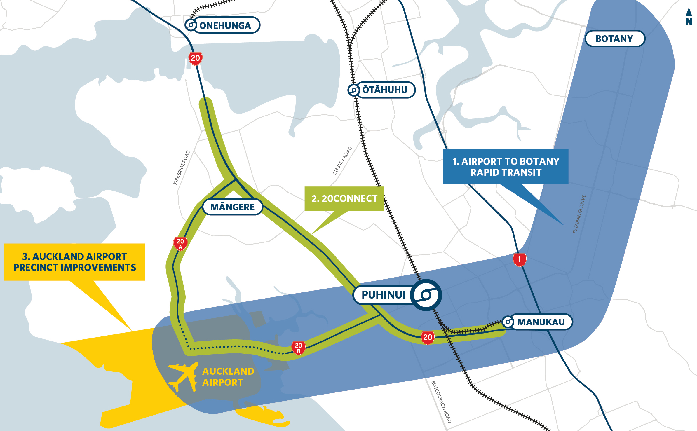
Improving access to the wider airport area has quickly become one of the most important pieces of work in Auckland for the coming decade. But there is not just one project to improve access but a number of overlapping and interlocking projects that have been pulled into what is called the Southwest Gateway Programme
Yesterday Auckland Transport and the NZTA launched the first, of what is bound to be many rounds, of public feedback about some of the elements that make up the Programme and there are three separate and overlapping projects within it.
- Airport to Botany Rapid Transit (A2B) – will see a rapid transit route built between those two locations via Manukau.
- 20Connect – is about improving the state highways in the area, but that includes providing PT facilities
- Auckland Airport Precinct Improvements – will make the changes needed within the airport area to support improved transport.
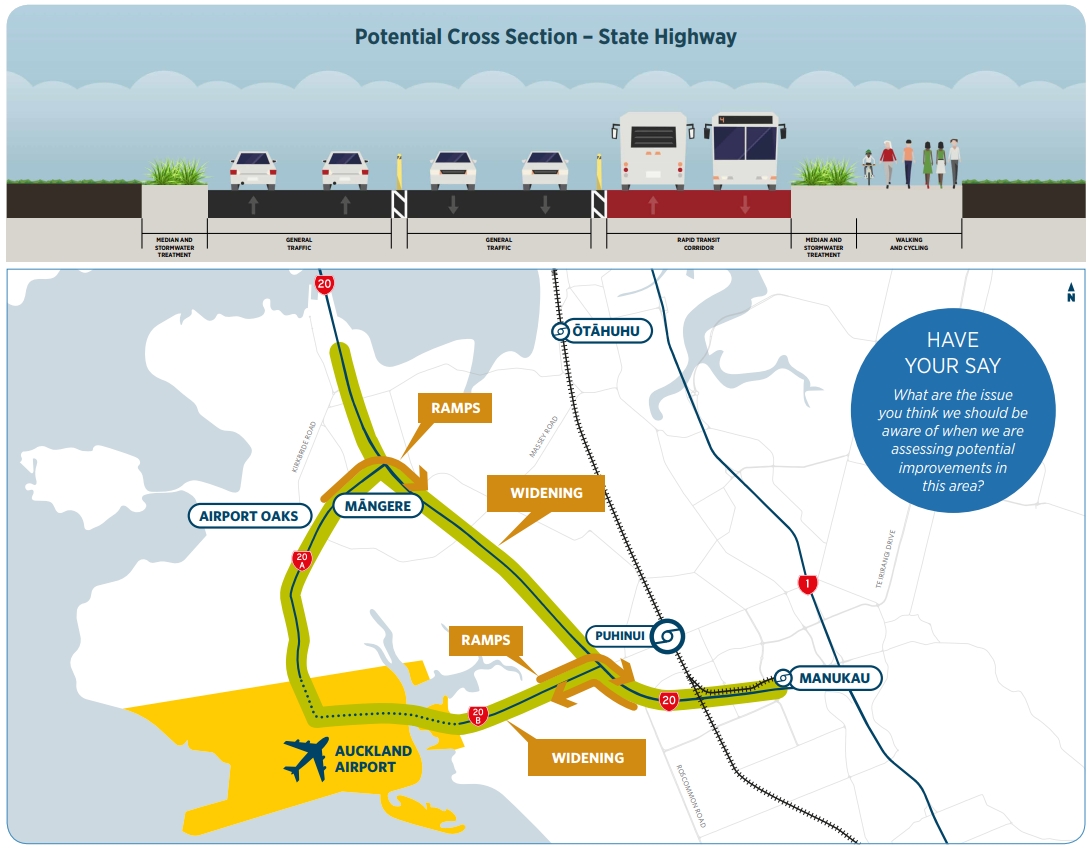
These are shown below.
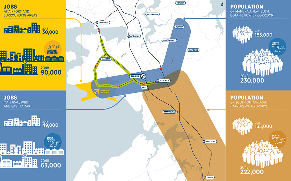
The programme also highlights how much we’ll need these projects thanks to all the growth that’s coming.
 On to the consultation
Airport to Botany Rapid Transit
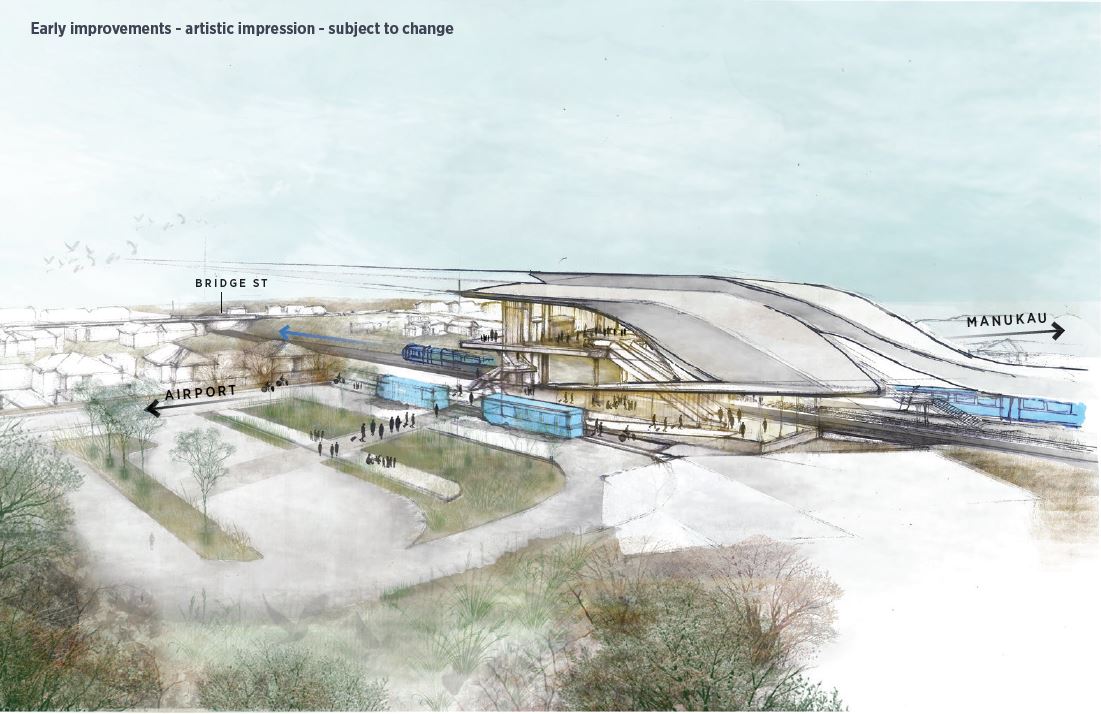
The first stage of the A2B project, due by 2020/21, will see a new bus/rail interchange built at Puhinui along with new frequent services to connect to it and bus priority measures on SH20B, Puhinui and Lambie Dr.. We highlighted the concept for the new Puhinui Station a few weeks ago but this new artistic impression has now been added to ATs website.
A second stage, for delivery after 2021, would see those airport services given a dedicated corridor. AT are already confirming that between Botany and Manukau that rapid transit will use the most logical route by going down Te Irirangi Dr. What they’re asking for feedback on are the sections from Manukau to Puhinui and from Puhinui to the Airport.
Manukau to Puhinui
From Puhinui to the route would use Puhinui Rd and then Lambie Dr at which point it would either they are suggesting two possibly routes.
- Ronwood Ave – This would go across the top of the city centre and therefore be shorter (cheaper) and faster for those coming from east of Manukau. It wouldn’t even miss all that many bus connections from those that use the Manukau Station as most travel north of the station to Ronwood anyway.
- Manukau Station Rd – this would enable services to stop in at the Manukau Train and bus stations but would be longer and therefore slower for those coming from east of Manukau, making it harder to effect significant mode shift.
This one is quite tricky as there are strong pro’s and con’s for either option
Puhinui to Airport
Again there are two options for this but the most desired outcome is much more clear-cut. The routes suggested are
- SH20B – Straight along SH20b to the airport
- SH20/20A – That the rapid transit would follow SH20 up to Mangere and then turn down SH20A to the airport. This idea is absurd, especially as Light Rail is already intended to serve Mangere Town Centre. The vast majority of potential users aren’t going to want take a 5km to detour for no apparent reason.
The various options are shown in this map.
![]()
I think it’s also good that AT show the line potentially extending past Botany as that would allow for more people to access the services.
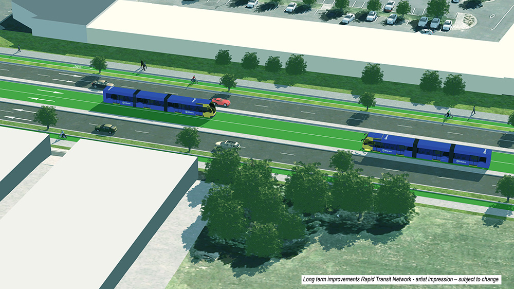
AT’s website even includes a basic artist impression showing a centre running busway with double articulated buses – which would be much better for those coming from the airport with luggage, as opposed to double deckers.
20Connect
As part of changes to the state highway network, the NZTA are asking about their long term proposals and the proposals. The NZTA say they’re considering:
- extra lanes on SH20 to support rapid transit to the airport and demand from the Western Ring Route
- new ramp connecting SH20A to SH20 (southbound) to free up local roads and improve freight efficiency (potential effect on Bader Drive)
- new ramps between SH20B and SH20 to provide a direct connection
- SH20B widening – motorway or urban expressway with high occupancy or dynamic lanes to support Puhinui growth.
I guess at least they show the busway alongside the state highway, and it’s cool that they’re using Streetmix for it.
The busway additions are good but the ramps would effectively create two new major interchanges, mini versions of the Waterview ramps.
Along with the data online, AT and the NZTA are organising eight public events. Check out the pages for more detail

 Processing...
Quite like the Puhinui station design. Looks like an airport type building, so good for an airport transfer station and looks like it should keep the rain out!
I’ve submitted my feedback on the stupid 5km detour. Hopefully they’ll see sense and not do that!
That detour looks really odd. I can think of some reasons for suggesting it but they all require my tin foil hat. In any case I have submitted my feedback. The project as a whole looks great and I think will have a hugely positive impact to the area. For me it could mean not needing to drive much at all which would be nice. I would rather they fast track this type of project than a lot of others NZTA are stuck on.
Dedicated busway with multicar bus trains. Perhaps even those painted line tracking rubber wheeled trainy busses. It all looks like great progress and the NZTA get back to their core mission of moar major roadworks, widening motorways, more road ramps, more access roads. That will keep the asphalteers in NZTA excited with the distinct advantage of putting the kibosh on these silly rails-to-airport looney tunes suggestions.
Or at least delay them for 50 years.
This’ll teach those silly Herald rail whingers. NZTA rules.
Basically, they weren’t going to suggest a project to connect a busway along Puhinui Rd unless it also involved a whole lot of road widening on other roads in the area. It would have been the same if it was a heavy rail connection to Puhinui Station – it still would have been part of a larger packet that included road widening. Because that’s what they do. This project will induce lots of traffic. Which means that throughout the city:
Safety will be compromised.
Access will be compromised.
Environment will be degraded.
Value-for-money will be nothing like if they just put in the busway to Puhinui (and eventually to Botany) and value-for-money on every single safety and active mode project they do will be lower (fewer people will walk and cycle due to this induced traffic).
In other words, it doesn’t meet the objectives of the Government Policy Statement on Transport. But because NZTA and AT don’t believe it’ll induce traffic, they won’t own up to this.
Bogle – I agree with you. Bi-articulated buses like in the above impression, as they are design for high density rapid bus routes using dedicate bus lanes/busways, using 100% biofuel and carry up to 300 passengers, like the Neobus Mega BRT Bi-articulated bus or the AutoTram Extra Grand bus.
More road widening. More traffic and congestion throughout the city. More danger. More carbon emissions.
Until we realise that road reallocation to public transport is the way forward, we’re exacerbating all our problems.
Disappointed you didn’t bring in the problem of a new or widened bridge on SH20B, Matt. I guess you’ll have swung opinion without people being informed about the issue.
Probably because comments have been deferred while the IMSB look at it (I asked the IMSB yesterday on their opinion of the duplicated SH20B bridge).
People are already submitting. So many progressive things can’t happen in this city until AT have done due diligence for a year, or consulted, or had more public discussion…
… yet when Maori have concerns, AT and NZTA are quite happy to just proceed without the issue being sorted first. It’s not like they haven’t known about the issue, and couldn’t have sought the opinion of the IMSB in advance. In 2016, Council said they believed that the resource consent process would provide for Maori concerns in this location. Whereas I’d say, why do they have to go through it again, when they’ve already been promised that there will be no new bridge or widening there?
Every road being widened by this proposal shouldn’t be being widened. And that’s bad enough. But maybe Maori having already said no to a new or widened bridge could be a chance to think again?
2016 was also a previous Government where Airport Rapid Transit in both directions was 30 years away while Sh20B was going to be widened regardless. So a flip around with Twyford accelerating A2B.
As with the IMSB they might have been asked in advance but given A2B has not gone to the Planning Committee apart from when Ive presented on it (and taken questions from the IMSB) their position might not be known hence I asked yesterday (and they are now going to have a look).
The failure here appears to be a past mayor making promises that won’t come back to bite his constituents until well after he has left office.
A local mayor making a promise in the 1990s that a State Highway will never be widened is extremely misleading, the local iwi deserved a lot better.
If this area was sufficiently sacred then it should never have been touched in the first place, or if the impact was too great on our biggest airport then it should have been settled once and for all with local iwi with an agreement that allowed for future widening.
Balls. There’s a clash here between a mindset that progress will always involve bigger, better, wider, faster – in this case, wider- and the mindset that we can respect our environment and our social and cultural relationships and be modest with our plans.
I agree that there is a clash between the mindsets.
My issue is with a past mayor who appears to have gone outside his mandate and has come up with a solution that could best be described as kicking the can down the road until it is no longer his problem.
The idea that we build transport infrastructure and say we will never come back and build anything more in the future is absurd, no one knows for sure what the future holds.
No the failure here is continuing to prioritise cars over other forms of transport.The fact that there is a restriction on the width of the bridge (whether or not the reason is valid) is a good thing.
The answer is painfully obvious and necessary, but NZTA / AT being the gutless dinosaurs they are it will never happen. The bridge should be closed to vehicular traffic and given over to buses (or light rail), and active modes.
It’s simply a shakedown by the local iwi.
Ultimately, better transport links will benefit their members who are working in the area.
Yip, but that doesn’t have to include a new or widened bridge.
Ronwood Ave – This would go across the top of the city centre and therefore be shorter (cheaper) and faster for those coming from east of Manukau. It wouldn’t even miss all that many bus connections from those that use the Manukau Station as most travel north of the station to Ronwood anyway.
No, it would just miss the 35, 366, 365, 368-9, 362, 313, 325, all the inter city busses that stop at Manukau, those doing Howick to the rail line, and waste time for those on the 33 coming in from the South. Would we really subject them to a 400m open air walk down/up a hill from Manukau Station to Ronwood Avenue luggage or pram in tow when you can have A2B interchange properly with existing bus and heavy rail services I wouldnt think so especially when A2B goes over to Light Rail.
Manukau Station is the best option for A2B to swing through especially as the area will receive a lot of civic development over the next 30 years under #OurManukau
The 313 and 368-9 go along Puhinui Road so would be fine for connections. The others could probably be solved with some rerouting given they are connector services, no reason to make a frequent service less direct.
In 30 years I doubt there will be many Intercity buses at Manukau anyway, much more likely for buses from the south to connect with regional rail at Hamilton.
313 is to be rerouted under the RPTP especially as the 36 will fire up post 2021.
As for the rest? That defeats the purpose of the Manukau Bus Station so easier to bring A2B down to where both an existing transit hub already is and where the bulk of civic and commercial development is going to end up.
No reason for it to defeat the purpose of the bus station, the connector services could simply run along Ronwood Ave before they reach the bus station.
This is a rapid transit service we are talking about re-routing, we don’t create doglegs in the train network just so it can call in and pick up passengers from bus services, we bring the connector buses to the RTN.
That is some 10 connectors plus inter city detouring to meet up with A2B on Ronwood Avenue when there is already a bus station in place. Again defeats the bus station and also creates a bus sausage down Ronwood Avenue which is designed to be a main street under Panuku’s Our Manukau (thus you end up defeating Panuku’s goals).
Use the existing infrastructure, use Manukau Station Road and the existing stations. By the time we get out to Botany the project will be light rail anyway so time loss will be negligible.
If Howick needs an express to the Airport for the twin peaks then a 35X running 4x a day is more than enough to handle that.
Manukau Station Road forms the core spine for the entire Transform Manukau area both northern and southern halves and having A2B meet that would be best fit to service the Our Manukau area
Seems like splitting the RTN route is probably the best as Ronwood neither serves the Manukau Station or the direct Botany to Airport that well.
Have half the services go via Manukau Station and the other half go straight from Te Irirangi to Puhinui. I think the direct Botany to Airport route will be too popular to just be served by a few peak expresses.
It’s one of the benefits of BRT that this sort of split can happen.
Also as the question was asked in the Feedback form: urban regeneration. With that in mind route selection falls to Panuku who are handling urban regeneration in the Our Manukau area. Panuku have said they have a preference for Manukau Station Road for A2B on connectivity grounds (AT say Ronwood for urban regeneration which is ironic given they are not the urban regeneration authority – Panuku is – who have said they want Manukau Station Road for connectivity grounds which you think AT would have covered and they did not.
He he… surely AT were well clued up on Panuku’s plans, because their adherence to the RASF process will have highlighted it? Ellison knows AT are not urban design specialists, saying that “AT will not be attempting to do so much of its own urban design.”
Is there a process not quite working here?
The car park between the Manukau Bus station and Manukau station road doesn’t need to be there. It could become a loop road for the bus station. That cuts out 2 sets of traffic lights. So the bus comes in from Ronward then down Davis road and around the loop road into the sawtooth then out back onto Davis and back out to Ronwood. If you wanted to go the full Heidi then you would close Davis and Putney as well for everything except buses and service vehicles.
One question I have got is how many bus stops or station is this busway going to have. For workers in the airport area itself there are a number of different stops on the 380 bus route so what happens there and would there be stops on Tre Irirangi and Lambie and Puhinui road or drives.
🙂
I think should be Manukau Station Rd for reasons already stated.
Another is: Even if most routes can connect along Ronwood & other theoretic connections, the simple legibility connecting to the Manukau Train & Bus Stations would be lost. This is important for casual & new users. Also don’t forget Auckland’s weather, especially around here?
Royce, a good place to do the full Heidi is Dominion Rd (actually it only needs to be the light version, in which cars can still access the properties). 🙂 See my comment at bottom of the recent post https://www.greaterauckland.org.nz/2018/11/19/nzta-finally-stirs-to-life-on-light-rail/#comment-285967
The bus route should definitely go via Ronwood Ave. There is little value from going past Manukau Station as the route also goes past Puhinui Station anyway, which offers superior connections to the rail network.
Fully agreed. The distance from Ronwood to Manukau Station is no more than from the end of Papatoetoe train platform, over the footbridge and on to the 380 stop. The Ronwood route sets up much better to transition to light rail and I believe we’ll see further ideas to that effect in good time.
Whaaaat? NZTA are proposing a busway for a m’way on no RTN plan? What cray freelancing is this? Just to make the detour seem plausible; methinks it achieves the reverse.
Just busway 20B, when it gets to the bridge merge the lanes but make general traffic give-away to the busway. Give the busway priority over the bridge. Should be pretty smooth, not that many buses, traffic calmed too. Sorted.
+1
SH20 to 20A isn’t as silly is it looks on paper, and is actually the preferred route – and quicker route – for a lot of people (including me) actually working at the airport when travelling from the south. That 5km isn’t that noticeable because it can be done at a steady 90kmh – in a truck – and the off-ramp is already there. I am talking about off-peak here, but when you are working out there you know when the peak inwards and outwards flows are.
But surely it is only quicker due to traffic. If you were driving a bus and each route had a dedicated bus corridor, 20B would have to be a lot quicker.
“Improved walking and cycling” = Shared Path. NZTA and AT propose this, but clashes between cycles, scooters and pedestrians are somehow due to evil scooterers and cyclists… the imbalance in our transport funding continues.
What would 20% of this project be worth, if we were following the UN guidelines on how much to spend on walking and cycling…
No one has mentioned the actual Airport Precinct yet – but it’s probably worth a post all on its own. Is the arrangement for Airport car and bus access the worst in New Zealand? Possibly the entire world?
I have a real issue with the stupidity of the way the buses have to thread their way through numerous 90 degree bends and then ends up in a corner, with passengers for the Skybus situated in possibly the most shit corner of the Domestic terminal. It’s appalling.
Say what you like about the car culture of Los Angeles, but at least they know how to keep the traffic moving. Auckland has the worst of both worlds.
It’s not ideal but it’s an improvement on the previous arrangement in that the buses don’t get caught in congestion nearly as much as they did. The domestic terminal is on it’s way out so hopefully the solution once they have a single terminal will be a lot better than it is now.
I haven’t looked for a while but I remember being amazed how little signage there was for PT. Most airports have big signs pointing you to the train station; in Auckland the big signs send you to the car park and taxis.
The bus passengers are outside at Auckland, near a big rubbish bin for the smokers. Treated like trash. Says a lot really.
ive thought for a long time AIAL deliberately treat PT users badly to aid in parking revenues.
It would be reasonably easy to provide a better route for buses on this route through the airport- create a bus lane through the eastern edge of carpark M from Lawerence Stevens Drive to the domestic terminal, then allow buses to carry on through past the Jet Star Terminal, up Fred Ladd Way and then Cyril Kay, up the unnamed road before the security gate and into the international terminal that way. You’d make it bus only with automatic bollards in parts that aren’t currently open.
You’ve pretty much described what is in place now, it was introduced late last year before the summer rush from memory.
No there’s no road through carpark M, the bus takes the main road in and out of domestic and it certainly doesn’t cut through in front of Jet Star, it goes back out to Tom Pearce Drive. Map here https://at.govt.nz/media/1908551/route-380-onehunga-to-manukau-july-2016.pdf
That map is well out of date, I’ve ridden on the 380 through the airport a few times in the last year. The buses take a route that leaves Laurence Stevens Dr and goes alongside carpark M, taxis also use this route to approach the domestic terminal.
It’s a bit of a rough route as it has some of the old carpark undulations but it is certainly better than battling the traffic. If you go to the Domestic Terminal forecourt map here https://www.aucklandairport.co.nz/information/airport-maps it is the yellow route marked Commercial Access.
After leaving domestic it now runs down Fred Ladd Way and takes a left turn into Cyril Kay Road.
Go through manukau would be better as it allow better transfer for the new bus terminal and heavy rail.
Could it be that the train and bus stations are in the wrong place and the argument of route alignment in Manukau is only an issue because of this?
If you were going to fix the issue, how would you fix it, for the good all in a holistic and long term manner.
The railway station was originally going to up by the main entrance to the Shopping Mal then MIT decided to build their building and that’s the mess you have now .
Actually it’s because the government funding only went so far, and didn’t cover the extension further to the site next to the mall. Manukau City Council was asked to cover the shortfall but for whatever reason they couldn’t or didn’t want to.
The MIT building over the top was only finalised after the station location was confirmed.
Linking all this into the wider picture, I have a few ideas and questions:
1/ Mill Rd shouldn’t be a widened road, it should be a piece of PT infrastructure. Any general traffic needs to be kept local with technology such as automatic bus bollards to prevent it being used as a through route which will induce traffic into the city. What are the issues with buses from there coming in to the Manukau Bus Station and then Puhinui Station?, so people can connect to services on heavy rail, busway, other bus?
2/ The city centre needs to radically reduce general traffic coming into it on the southern motorway. That motorway needs to offer a busway and only have one lane of general traffic coming in onto Nelson St. Buses from Mill Rd could stop at Manukau Station and then go on the motorway. You’d obviously want some other stops along the way – presumably especially where the rail and motorway diverge the most. Which other places should such a bus have a stop along the route?
The busway could come from Te Irirangi drive onto Hollyford drive then over the motorway on Redoubt road and go straight to the bus station. That would also be useful for buses coming to Manukau from Mill road. And it would be useful to get Intercity buses from the Motorway and buses coming from Great South road as well to the bus station. In fact I was thinking they would use that route for the busway and I was a little bit surprised that they went for Cavendish drive. It was how I envisaged light rail would get to Botany. Off course Redoubt road with its motorway on ramps get pretty busy.
On the rare occasions that I drive from Manukau to Botany I go that way because you avoid Great South road with its window washes.
Yeah, unless Nik’s suggestion of moving the station locations is the better one, it seems to me they need to plan to maximise the advantages of where they are, and I think your ideas do that. Redoubt Rd has a history – would be nice to give it some PT love and strip it of the congestion from SOV’s. So many stations in the area (train plus busway) that there shouldn’t be a need to plan around SOV traffic if they do this right. It can be diverted elsewhere.
Well you are going to have to transfer from bus to rail somewhere. The bus station is in the right place you could criticise the location of the train station. which many of us did at the time however I am more happy about its location now as it is between the city center and Mall and close to the super center. just a quick walk through the park. Although crossing Lambie drive is a bit of a challenge. We could have a pedestrian bridge across Lambie drive.
You could imagine buses from Mill Road continuing on to Puhinui Station if you wanted to but the only advantage of that would be for passengers wanting to go on the Southern line. The other alternative would be to run trains from Manukau alternately on the Southern and Eastern line but that reduces the frequencies.
I’d keep the trains as planned, and take the bus to Puhinui. Yes, it would double with buses going airport to Botany, but without being able to plan from scratch, a double up is going to happen somewhere. Maybe the bus should then go further. Mangere? Onehunga? Avondale? 🙂
If they don’t do this, someone living in Mill Rd, working in Onehunga (or Mangere) would take a 4 leg journey: drive, bus, bus, train or drive, bus, train, busway, light rail.
Seems to me those new subdivisions need some serious PT consideration, and once you add those in, the CFN3 might need another major line or two.
Well I am not to sure about getting to the Manukau bus station from Mills road but from there you can catch the 380 to the airport or 313 will take you to Mangere Town center and Onehunga so no need to use the train. So should be only a 2 bus trip. The 313 winds around a bit but it will get you there. Yeah keep the trains as they are and run through buses to Puhinui for workers who want to get to Penrose or Ellerslie to avoid a three leg journey. If you work in Avondale I would suggest you get a new job.
OK, I thought some of the buses might be dropped once the light rail and busway are in place, but you’re right. Yes, it looks like there’s no bus routes at all currently on Mill Rd. Of course they couldn’t be justified on a farebox recovery ratio. But that’s so short-sighted. People in the new subdivisions here, like those in the NW and North, will form habits and patterns in their lives around their transport options now. It’ll be way too hard to shift that later.
When they built the bus terminal why did they not install 2 escalators and dig a tunnel through to the railway station like they did at Britomart to cross lower Queen Street ? And their are a couple of spares available from downtown they could have used .
Does this mean the built the Manukau bus station in the wrong place? Always seemed the unpopular Ronwood Ave carpark was a better location.
I have asked AT about bus stop place on Lambie Drive for the 38 and 36 that would service that part of Airport to Botany RTN stage 1
Should know some answers next week.
They showed the new station on 3news tonight and with a price of $60million . And then had Phil Goff talking about the reason why HR is not going to the Airport as it will remove 10’s of thousands of houses to build it , what the heck was he smoking when talking to the reporter ? and he had that goofy smile when he said it .
https://www.newshub.co.nz/home/new-zealand/2019/05/auckland-a-step-closer-to-airport-rapid-transport.html
and this from TVNZ’s 1news :-
https://www.tvnz.co.nz/one-news/new-zealand/getting-aucklanders-airport-60-million-public-transport-project-creates-division
Aghhhh what is this group that thinks it’s “so obvious” we should be using HR spur to the airport. Lol check out the many posts and thousands of comments on this blog as to why not.
Yer dreaming mate, there aren’t many posts and thousands of comments as to why not. Your exaggeration is in good company too since Goff makes silly claim tens of thousands of houses will be removed in order to build HR to airport.
But it’s an academic argument, we are getting the best compromise with a decent express busway from Puhinui to Airport.
What gets me is that this going to take 18mths to build and they are going to start in October to be ready when APEC starts and if you look at their [APEC] website the talk fest starts :- This from Google and Internal Affairs – ” APEC 2021 will be the largest event ever hosted by the New Zealand Government and is an opportunity for New Zealand to shine on the international stage. APEC involves a 12-month period of hosting from December 2020 to November 2021. APEC meetings will be held in Christchurch, Wellington and Auckland. ‘
So how does starting in October equals 18mths to start of APEC . So by AC’s calculation’s , October 2019 to December 2020 = 18mths not 14mths by the average man’s calculation’s no wonder they can’t get things right
There’s usually a big gathering for a few days during APEC, not sure when it is this time around but I’m guessing this is what AT are targeting.
Looks like AT have missed the boat (sorry couldn’t help it) with the Americas Cup, although I’m not sure many sailing fans will be catching a bus and train to their hotel anyway.