Bernard Orsman seems to be on a campaign against the new bus network in recent weeks. After a few beat-ups over school buses he’s now turned to how the new bus network affects people travelling to Greenlane Hospital:
Auckland’s elderly are rattling their Zimmer frames at Auckland Transport for “dumping” them on the roadside to receive medical treatment at Greenlane Clinical Centre.
The axing of a bus service into the clinical centre has angered residents at Selwyn Village in Pt Chevalier and in Mt Roskill at the other end of the cross-town route.
The furore is over AT’s decision to no longer take patients into the clinical area, but drop them at a bus stop outside the gates of the hospital on one of the city’s busiest roads.
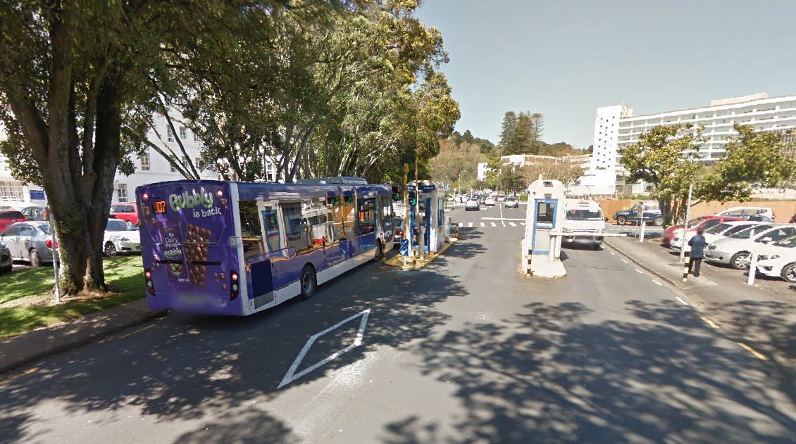
Wrapped in a warm jacket, fitted in podiatry shoes, standing straight as a fence post over a walker and wife at his side, Peter Dunne caught the bus to hospital today.
Not just any bus, but the new 650 bus that takes residents from Selwyn Village in Pt Chevalier and “dumps” them on Green Lane West to walk 300m, via a pedestrian crossing on one of the city’s busiest roads, to the Greenlane Clinical Centre.
Until last month, the elderly, mums with sick children, people in plaster casts and using crutches, could catch the 007 bus on the same route and be dropped inside the hospital grounds.
It’s hard not to feel for Mr Dunne, as this change has clearly made his life much more difficult. But I think there’s much more to this than Orsman presents.
Bus route trade-offs
There is always a trade off with bus routes and every time you deviate from a direct route it adds time, thereby making it less attractive for everyone not going somewhere along that deviation.
The 650 bus now travels directly along Green Lane West, rather than making a detour into the hospital grounds. AT say this saves up to five minutes
By not venturing into the grounds of the Greenlane Clinical Centre, it avoided the need for buses to turn at a set of traffic lights, wait for an entry barrier to be lifted, drive around a carpark and repeat this to leave, he said.
You can even see this from Streetview with an 007 waiting for entry at a barrier.
The vast majority of bus users are probably seeing a decent benefit from the change. The 650 bus after all is a key cross-town bus route from Pt Chevalier to Glen Innes.

Perhaps another way of thinking about this is to look at the impact of reinstating the trip via the hospital. On a normal weekday there are 78 services of the 650, 41 westbound and 38 eastbound. Timetabled travel times vary from about 45 minutes up to 65 minutes depending on the time of day. To detour services into the hospital at five minutes each, it would add about 390 minutes of in service running. Depending on the time of day that’s the equivalent of 4-9 services. To maintain current frequencies, you’d either have to cut those services (or ones somewhere else) or find another source of funding. For the few Selwyn residents who can’t walk far, it’s probably cheaper just to buy them a taxi fare than divert buses to the hospital.
Better Pedestrian facilities needed
Zooming in, I wonder whether the bigger problem is with the layout of the hospital grounds. There might also be an opportunity to provide a better located pedestrian crossing and bus stop. After all, the hospital directly opens out onto Green Lane West so it should easily be possible to have a very short bus-to-clinic walk without forcing the vast bulk of bus users who aren’t going to the hospital into a lengthy detour.

This is a good example of why it’s important for critical land-uses to “be on the way“, as Jarrett Walker phrases it:
If I could put one sentence about transit in the mind of every developer, every land use planner, indeed anyone who makes a decision about where to locate anything, the sentence would be this: Be on the Way! If you want to be sure you’ll have good transit, be on the way from one transit destination to another.
An efficient transit line — and hence one that will support good service — connects multiple points but is also reasonably straight so that it’s perceived as a direct route between any two points on the line. For that reason, good transit geography is any geography in which good transit destinations are on a direct path between other good transit destinations. (Obviously, this is not always a geometrically straight line; it may be a path defined by existing roads or rail corridors that everyone perceives as reasonably direct given the terrain.)
A bad geography is one that indulges in cul-de-sacs on any scale: It sets destinations a little back from the line, so that transit must either bypass them or deviate to them, where deviating means delaying all the other passengers riding through this point.
The same problem arises at many scales:
- A person who lives at the end of a long cul-de-sac road complains that the bus doesn’t go by her house.
- A small shopping center or grocery store sets itself too far back from its street, even though the street is where the transit service is.
- A university, hospital, business park or other campus-style development positions itself on a hill, often at the end of a road leading only to it, or on a road at the edge of the city where there is nothing further beyond it. This makes the institution look and feel important, but limits the possibilities for transit service because it can only be served by lines that end there.
- An entire suburb, perhaps one called a Transit-Oriented Development, is located in such a way that no regionally logical transit line will ever get to its town center, except for routes that go only there. One of the major failings of Peter Calthorpe’s early 1990s project Laguna West, in Sacramento, is that the town center is located in a place where no regionally logical transit line could ever serve it. Laguna West still has mediocre transit service because it’s impossible to combine its market with any other markets, which is what you have to do to create an efficient transit line.
Land use planners urgently need simple tools to catch these problems. Until those tools are developed and built into training, they’d do well to just remember one sentence: Be on the Way!
Before pointing the finger at Auckland Transport’s new network, maybe there should be a discussion about how the hospital’s layout over time can better orient itself to the important bus route passing by its front door, to be truly “on the way”.
A potential solution
I think there could be a way to make everyone fairly happy. Even better it also fixes one of the New Network’s biggest flaws, the Outer Link. Here’s the network currently:
The Outer Link, being a loop, is notoriously unreliable and often suffers from bunching. Auckland Transport had originally proposed split the route up but changed their mind following initial consultation. They need to revisit that.
One way to think about the route is as a triangle. On the western side the route is logical and useful, same on the eastern side, although it duplicates either Manukau Rd or Inner Link buses for it’s journey. The biggest concern though is the cross-town section, from Mt Albert to Greenlane, including its detour via Valley Rd. That detour makes a stop in the hospital look tiny by comparison.
The basic idea is to break that cross-town section away and use the freed-up resource to turn the 650 into an all-day frequent bus. That would leave the Outer Link with two distinct ends and the eastern end could be diverted to stop at the hospital.
Below is a map I quickly pulled together. It only shows the frequent routes and the rail network. You may also notice that I moved the 20 route to terminate at Newmarket to give us two new frequent cross-town routes.
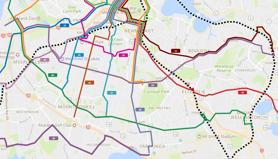
This map could solve the hospital issue, solve the low frequency cross-town and make the network more like a grid, which is always how it should have been

 Processing...
Well I don’t think your plan would solve “the hospital issue”, because there is already a hospitals bus that goes into Greenlane, along with all the other main hospitals, and there is already a bus that goes right from the front door of Selwyn Village.
The ‘issue’ as they have framed it, is there is no one direct bus from that one particular retirement community to the inside grounds of that one particular hospital. Moving the Outer LInk doesn’t change that.
If this is such an issue for Selwyn VIllage, why don’t they run their own hospital shuttle with their vans? I don’t think any other retirement community gets a ratepayer funded direct link to their favourite hospital.
The blame also falls on ADHB who are happy to spend a lot of money expanding their parking at all their locations (and have basically turned Greenlane almost completely into a vast surface level carpark now) but seem completely uninterested in improving the ability for people to reach the hospital by bus. The entrance is oriented to the rear where the carpark is, when arriving by any other means it’s not at all clear how to enter the building.
I am not aware of any new parking at Greenlane Hospital and I have been going there every three months for 15 years. The issue is they have crammed more services into Greenlane and they are services that treat people for all over the region so of course they need parking. Truth is they are short of parking and what they have is really poorly run. They let you pay inside at a machine, they let you pay to a man at the main outside carpark and they let you go past both of those if you want and pay at the main gate where old people stop and wait until they can remember their pin number all the while blocking the entire exit for cars and buses. When I fist went to Greenlane it was run down and old and had few services offered from there. Now it is run down and old and full to the brim with people waiting to see someone. 90% of the cars are people waiting inside, the other 10% are actually being seen. But hey you can’t expect doctors to provide a timely service can you.
I’m with miffy – I’m a frequent visitor to Greenlane and their parking is very minimal.
It was raining hard during my last visit and I went to the very bottom level under the main building. Grabbed the 2nd to last car park.
The bus stop is in the wrong place though. Needs to be by 212 Greenlane W, just by the carpark entrance for the ophthalmology centre. Gives a ~30m walk to a covered entrance instead of the 100+ walk now.
Exactly. The entrance is horribly located,but it shouldn’t be hard to fix.
I go by bike to most of my checkups and find it’s a horrible layout for all users. Narrow roads that make cyclists conflict with cars, cars forced past the main entrance to put them conflict with pedestrians. No logical foot route to get to the main entrance once you’ve found a park. No good cycle parking, just an 80s school bike rack (better than nothing)
At the moment you can go in the main entrance (GCC) and walk a very long way to the eye clinic (building 8) at the northern end next to the road. See the map here:
http://www.adhb.govt.nz/documents/greenlane_3d.pdf
I’d leave the stops exactly where they are and simply add a public entrance via the eyeclinic. There is already a path, see here:
https://www.google.com/maps/@-36.8931419,174.7801523,3a,75y,187.69h,73.09t/data=!3m6!1e1!3m4!1sdSb8NuSdJITmS3tuo-OEyQ!2e0!7i13312!8i6656
Next add a signalised pedestrian crossing so that those on the east bound service can cross the road directly. Synchronise the timing with the lights on the vehicle entrance to the grounds and you wont be adding any delay to passing traffic.
Good Idea and should be an easy fix. I like how on the Map you linked to the Public Bus stop is barely visible. Show how the Hospital thinks people will arrive. Parking well posted yet buses well hidden. Also it refers to MAXX which has been discontinued for a while.
Yes, I didn’t see your comment when I wrote my similar one.
AT have stated that they will revisit the Link services next year, so they will likely be broken up into better crosstown routes
I would like them to also revisit the city link to have uphill via queen st and downhill via greys ave
Right hand turn out of Queen into K is no easy thing. Which is why it goes the other way, I assume. What’s your reason?
Kelvin mentioned this yesterday and I think it’s a good point. If you’re not very physically able, and are wanting to go up Queen St to something, you want to get off the bus and walk down a little bit. Not so much to get off for on Greys Ave. Of course you could take the bus all the way around the other way, but that takes ages.
Yea that’s right. It also solves another issue is the shops and apartments and shelter are on the upper queen st is east side. However when the bus goes down hill it drop people off west side, which is windy and has no amenities in comparison.
The story is an issue with the Hospital design, as noted, it’s built for cars and that is not AT’s problem to fix.
That whole area is a disaster, Cornwall park should be a paradise, but it’s extremely unpleasant to get to any anything but a car (and then trying to park if you do). There is no bus stop near the entrance. There is no footpath near the entrance.
Yes, I used to try to take the 007 to One Tree Hill with my kids but it was just a pedestrian amenity nightmare due to the lack of bus stops and pedestrian crossings where you wanted them. Greenlane Rd needs to go on a diet.
But hey, at least there is a cycle lane between the park entrance and Epsom.
(fine print: only usable if your bicycle is no wider than 30 cm)
Agree. It’s no different within the park. On a fine Sunday there are hundreds out for a walk, but on the NW side of the mountain they are forced into a narrow footpath, all to allow cars to drive through the park. I’m not sure why we need cars to drive through One Tree Hill/Cornwall Park.
How quintessentially Auckland.
We’re quite eager to send cars on a tiki tour through those parks. I’ve driven many kilometres in the rat maze in the Domain. (Hint: if you provide parking at a big park maybe make it so you don’t have to drive around through the entire park to reach it)
I was at the stardome a while ago, and the little parking lot at the observatory was closed. But they had a sign pointing towards “more parking”. The problem was, that sign was pointing west. There is no parking that way. What you get is this little road, with no footpath, no lighting, and quite a few people walking there. Yay, thanks for sending me (and lots of others by the looks of it) that way.
Restricting vehicle access to the summit has been a major improvement, next step has to be making the ring road around the base one lane and one way. This would free space for pedestrians and cyclists.
Agree entirely. The current walking route around the hill is beyond totally inadequate. For a large part it is a very narrow uneven path jammed between the two lane road and a heritage basalt wall. It is incomprehensible that those who are not in cars have to sacrifice so much to enable passage to those for whom a trip to the park does not even require them to leave their air conditioned seat.
Which direction?
The issue could be solved by building a parking building at Greenlane Hospital and moving the barrier in to the entrance of that building. Currently they have this bizarre system of stopping everyone at the gate, buses included, then you all have to drive between the hospital entrance and the main footpath where you get to stop for the infirm at a zebra crossing that causes queues back to the entrance and delays the buses, then you get to drive around a triangle of land that was probably just spare space in 1950 so they marked out a few spaces. Then when that does get you a space you go into the bowels of a building designed by a technical drawing student who had a headache.
Meanwhile anyone who finds a park in the main area then has to walk on poorly aligned footpaths then get across a really busy zebra crossing that carries to much traffic to get in the door.
IIRC the 650 is slated in the future to become the Frequent 65. It would be a disaster to have such a service wind its way through the hospital. Havin “transited” the hospital in the past, I think that a 5min delay is conservative!
Build an airport style pedestrian link out to Greenlane Road. Add travelators. Add a great station with quality access to cross Greenlane Road.
Next problem? North Shore? Same problem, same kind of solutions.
I sympathise with elderly folk having to walk further but a better solution in this case is some sort of subsidized shuttle, rather than sending buses into a badly laid out hospital. And move that bus stop like someone suggested.
Hospitals, like airports, are large and usually involve lots of walking once within, but does this not count in people’s reckoning??
Matt, your route reconfig for the Outer Link and your frequency upgrade of the 650 service, are very sensible proposals and I hope AT go ahead with them.
AT needs to put in better-designed shelter at its two bus stops on Greenlane Road outside outside the hospital put in a better ped crossing there to connect them. The DHB needs to build a covered walkway between the bus stop and the main entrance to the Clinical Centre. This is what is done in Singapore – there, the LTA and SingHealth collaborate to provide decent bus stop shelter and covered walkway access between bus stops and hospital buildings.
Changing the bus network materially making life more difficult for the most treasured amoungst us, our senior citizens, my grandmother, your grandmother, is bonkers.
Public Transport is a service for PEOPLE. There is a balance to be struck between efficiency at all cost and the needs of the people. For goodness sake we are talking about a HOSPITAL. For sick people. On a bus route..
It’s a stuff up. Period.
‘Public Transport is a service for PEOPLE.’ You are right, it is also for the 95 % of people who use this route and don’t go to the hospital.
Including elderly people and people of limited physical ability going to places other than Greenlane hospital, and going to Ascot hospital. These people don’t need to have to wait an extra 8 to 15 minutes (I don’t believe the 5 minutes) on each trip they take.
Seriously…?
Seriously what? These are my bus routes. I don’t own a car. I take the 650 regularly. There are plenty of elderly on it, people with limited physical ability, people with small children who can’t walk far. And most don’t get off at the hospital. Which part of it are you not sure I’m serious about?
Don’t get me wrong, I think we need to plan our city and our transport around the needs of the most vulnerable, including putting far more funding into better pedestrian amenity. But that’s across the board – it most certainly means putting roads on diets so there is less severance and healthier streets. It most certainly means filling in at-grade carparks with buildings and amenities like parks so that people can live and reach what they need within much smaller distances instead of having to commute long distances due of sprawl. And it most certainly means rewriting the planning rules to require places like hospitals to redesign their layout to enable the main entrance to be on the main road, where there is a bus stop, and allowing the bus network designers to put bus stops where the network requires them, without regard to their effect on traffic flow.
Is there not a dedicated service going to the hospitals in the form of the 321 route? It goes every 30 minutes. Maybe do an adjustment to the timings of either the 650 or 321 and there could be a transfer point on the common route along Greenlane west between the Drive and the hospital.
The other thing to remember is what about those not fortunate to live in Selwyn village. They have to Walk from Manakau road if they catch the 30 route or Outer Link or Great South Road if they catch the 70 Route. Why should a very limited group have a dedicated detour when others do not.
Going back to the early 1990’s I remember catching the old 312 route which had every second service travel via National Womens Hospital. The following none detouring bus was always full as people didn’t want to take the 10 minute detour through the hospital. People want to get where they are going with minimal detours. If you detour for every Tom, Dick and Harry wants to go then people will just use cars to travel.
If people want direct services that detour to every destination and they can’t drive themselves then there is something they can use. It’s called a Taxi. Public Transport can not deal with everyone’s individual travel plans. It can only try and alleviate the masses general journey.
Someone in my family is a regular user of the 650, and before that, of the 007. His reports of how long the 007 detour into Greenlane Hospital took were always more than 5 minutes: I’m sure sometimes he said it was more like 12 minutes.
There’s another Hospital problem with the 650 which is leaving him high and dry after his afternoon job in Greenlane. There is no bus stop on Greenlane Rd East between the roundabout and Peach Parade. So he has to cross Greenlane Rd East and walk into the Ascot Hospital grounds. Which is fine. Except that, often as not, the bus drivers drive past Ascot Hospital, not making the detour to this one stop. He doesn’t have a smart phone, so it takes a while for him to know the bus is not coming, and then he has to make his way to the train station, and guess as to whether the best way to Pt Chev is south to Penrose for the 66 or north to Newmarket for the Outer Link or to Britomart for another bus: the journey planner alternates which one is best once the 650’s have stopped in the evening.
Ascot Hospital isn’t exactly transit-oriented either, but they don’t even have the option of a stop on the main road. Bring on the changes you’ve suggested, but also bring on some bus stops in places we need them! I like the 20 ending in Newmarket, too.
+1
Also how can we have transit priority & reliability through this mega traffic light & roundabout so we don’t just end up with bunching of a future frequent 65 crosstown route?
Is there a case for some sort of bus lane combined special bus only advanced lights & (regarding the roundabout) give way rule changes so that they can waltz on through and the general traffic basically have to give way?
Short on that you would have to build a mega bus only overpass of some sort which would be pretty ugly and need room at each of the landings.
“it’s probably cheaper just to buy them a taxi fare than divert buses to the hospital”. And then we have the discussion about who will pay for the taxi fare. Hint, it will be the person wanting to get to the hospital. And there in a nutshell we have the very essence of user pays. Services sliced and diced and priced for the individual. If you added all of the user pays charges effecting you, you would be paying far more than under the old model where the cost was simply divided up amongst everyone and negligible for the individual. Compare the angst about the comment from AT about the walk up to K Rd from the new underground station to this. Its fine. It is just 300m across a busy road. The only thing missing was “It will be good for them”. The requirement for the route was that it delivered unwell or disabled people to the hospital. I don`t see how that requirement has changed. “Adding 5 minutes” is not a good argument. against the stop. Imagine the time savings if we removed all of the stops. Public transport is a public service, not an academic exercise in urban planning. Remember that!
‘The requirement for the route was that it delivered unwell or disabled people to the hospital.’ Do you know which document this requirement is listed in? I wasn’t aware there were specific requirements for bus routes.
This is very much a case of the needs of many vs the needs of a few. If AT are correct only 5 % of the 650’s users are going to Greenlane Hospital, so the remaining 95 % would have a significant detour on their trip and may chose to drive instead. This would make the route much less viable and at risk of being cancelled.
In Orsman’s first article, it states that the 5% is only of Selwyn Village users, so an even smaller number of total users
GA, take note about the public’s need for access to hospitals when considering the stopping patterns for the southern line. A friend of mine who works at Middlemore said the nurses who have changing shifts will be put off using the train if the regularity of services is reduced and if they have to concentrate on doing different things at different times of day or night. If it’s sometimes much longer by train, they’ll take the car for those shifts, which means they’ll probably start taking the car for all the shifts. And the carparking is scarce. Just a thought…
I imagine the off-peak frequencies will be much better than they are now once the CRL opens, this would likely negate any impact of having one line run express through Middlemore.
Green Lane hospital is a major public hospital next door to a major Auckland park and across the road from the (only?) Auckland show grounds. Next to that is a new residential development I believe will incorporate shops and restaurants and a racing track. They all lie along one of the few direct roads running EW across Auckland.
I would have thought that group of destinations on that road would clearly justify a frequent route linking them to all three train lines and as many of the frequent NS routes as possible. All of those destinations should be made as accessible as possible by public transport – that might help reduce the traffic & parking chaos caused by every big show or “fine day to take the kids/grandparents to the park”.
An air bridge over the busy road would be fantastic but at the least, the road through here should be designed to facilitate pedestrians, public transport and cycling (could fit a lot of bikes in one of those Cornwall Park car parking areas).
Fully agree.
I’m surprised AT and the ADHB haven’t agreed to move the internal bus stop to the north side of the roundabout, to facilitate quick turning, like they planned to. The stop would be closer to the entrance on a flat and easily weather-proofed path to the door. Why can’t we all just get along?
And I suppose that the buses still drive all the way to the southern end of the site just to access that poorly-placed bus stop? I guess they want you to feed their parking machines. Do the taxis pay a fee for access as well? Cynicism.
Greenlane West is an over-dimension route for heavy haulage with a recommended minimum 6.5 m of vertical clearance. Maybe it would have to be an underpass for pedestrians?
That’s an important parameter. That’s too high an overpass. And underpasses aren’t generally liked nor good for people with rickety knees. A surface pedestrian crossing is what is required, where the bus stops are. I’ll go into that in another comment below.
I wonder if a T3 lane would work here (obviously you get the compliance issue) rather than a 24hr bus lane in each direction. This could then move to a bus lane once and if people transition from car to bus mode. Would be tempting to move the stone walls and make more road space but this is not reallocating.
With the Greenlane Clinical Centre, the issue is _where_ the bus stops.
The bus stop is in the wrong place. If it were by 212 Greenlane W, just by the carpark entrance for the ophthalmology centre, you’d have a ~30m walk to a covered entrance instead of the 100+ walk now.
You’ll still have issues getting to the return bus, unless another pedestrian signalised crossing is installed. I don’t think there’s an entrance to the ophthalmology centre from the northern side of the building…
Jon, you’re right. This is the solution. The bus stops need to be at the pedestrian crossing.
If that is at the existing crossing, then:
a/ the missing leg of the pedestrian crossing needs to be filled in
b/ the footpaths need to be wider to accommodate wheelchairs without poles getting in the way: https://www.google.com/maps/@-36.8931699,174.7795264,3a,60y,207.14h,69.64t/data=!3m6!1e1!3m4!1sTz8Rz6QAwx3bMSjbimidMQ!2e0!7i13312!8i6656
c/ the carpark on the corner needs to be replaced with a new main entrance building, from where you are shown how to easily walk to your clinic, or from where you are taken to your clinic.
d/ the bus stops need to be moved to be adjacent to this crossing.
Alternatively, the bus stops can stay where they are, with a new pedestrian crossing added:
a/ they need to convert building 8 to a new main entrance building: https://i.imgur.com/o4MkpIq.png from where you are shown how to easily walk, etc, as above
b/ a new signalised pedestrian crossing needs to be provided between the existing bus stops – in sync with the existing one.
c/ special attention to the footpaths at the pedestrian crossing and bus stops needs to be made. Probably the bus shelters need to be set back into the hospital grounds. Maybe the bus stops need to not be indented, as is happening elsewhere.
In either case
a/ the pedestrian crossing phasing needs to ensure no pedestrian has to wait more than 30 seconds, following NZTA best practice for urban areas, and absolutely vital for hospital patients
b/ the 650 needs to become both frequent and have a longer span. It should be able to serve hospital staff getting to and from night shifts.
c/ the hospital needs to relayout its grounds to enable easy pedestrian access throughout with clear wayfinding.
RE building 8 – Yeah, a front facing entrance would be nice.
There’s an entrance already between building 8 and 6. It goes to the ophthalmology reception and main corridor.
If keeping the existing stops, then a new entrance on the northern side of the unmarked building between 8 & 7 would be a great benefit.
Funnily enough you see exactly the same problem around Smales farm.
The “North Shore events centre” is about 1 km as the crow flies from Smales Farm, and yet it’s still 20 minutes away without a car.
And the North Shore hospital is so close to Smales Farm, but it is away from both Shakespeare Road and Taharoto Road.
Both of these are now forever unreachable by frequent public transport.
Unfortunately you are wrong on North Shore hospital being “unreachable” by public transport (even though there is a bus stop on Shakespeare Road entrance) because the service that links Beach Road with Milford, Smales and then Takapuna (currently part of the 858 route) will continue to go through the hospital and add a time delay to the service for non hospital users. Seems like AT is inconsistent in its approach here.
It’s not in general unreachable, but I don’t think any frequent services will ever make that detour. Line 83 will skip the hospital. Other lines will still go via the hospital. The 941 and 856 will be absolutely crippled by the time it takes to detour to both Smales Farm and the hospital.
There is a simple fix that would not inconvenience the 95% of users that are not going to the Hospital yet making it easier for those actually going. Move the Eastbound stop closer to the intersection and add the missing leg to the pedestrian crossing. As long as there is enough room for the 321 route to actually stop at the moved stop then there shouldn’t be a problem.
Also I wasn’t aware that the 007 route used to go to Mt Roskill. Apparently according to the article It has angered residents there as well.
Fascinating that entrances to major public institutions all now face the carpark and not the street as a result of 70 years of twisting everything in cities to suit the car. we will spend the next generation turning them all around again…
In-line street side bus stops and street facing front entrance, proper crossings (with real bike lanes), would fix both the service speed and efficiency, and the accessibility. Done.
The real question for me is why Bernard Orsman writes these articles. The real issues the New Network seems to face is that the required new double decker buses weren’t part of it, and that the way finding, bus stop locations and pedestrian amenity weren’t things the NN could influence, which detracts from the great network. Apart from these issues, the new network has provided much more accessibility than it has removed. Where are the articles saying how there are now so many more suburbs where it is quite feasible to ditch the car?
oops didn’t mean to be a reply to you, Patrick. 🙂 If it was, I would have said, yes, I agree!
Orsman writes for an audience. That audience is grumpy conservatives and NIMBYs who think Auckland was PERFECT when they bought their Grey Lynn villa for $50 grand in 1983 and any changes to its set-up is an OUTRAGE designed by politically correct greeny namby-pamby rainbow cultural Marxists.
It’s just Bernard’s MO. He finds a complaint against the Council or a CCO and amplifies it. Either he believes this is the most direct route to compelling stories, or he’s doing god’s work in doing so, or both. Sometimes he raises valid concerns, sometimes not so much. Either way he doesn’t dig much past the public as victim idea to get fuller picture, and always, always, there is the subtext of the evil machine trampling on the hard done by battler. A time honoured journalistic trope.
Now the Herald also has Simon Wilson on the city beat who digs much deeper, asks more compelling questions and tries to get down into the real stories on more sides i feel this approach of Bernard’s is looking very dated.
+1. The contrast between the Wilson and Orsman stories was so obvious. Orsman is a hack who only cares about building controversy. Simon Wilson can deal in nuance.
When are the elderly at Liston Village and Ranfurly retirement home going to rattle their zimmer frames at Auckland Council about the lack of a direct service to the door of the Greenlane Clinical Centre?
At the moment the 27H service just dumps them in the gutter at Balmoral Road, If they are lucky and are not mugged at the intersection, they must then battle for 2.0km east along the broken footpaths of Balmoral Road and Greenlane West. It’s as though the council considers them dead already.
Totally inhumane for Council to run public transport like this.
From the 27H you should be able to take a frequent 65 service along to Greenlane Hospital. And the pedestrian connections should be easy and comfortable and short. Instead, look at how far apart those bus stops are: https://www.google.com/maps/place/Green+Ln,+Auckland/@-36.8898128,174.7583501,16.93z/data=!4m5!3m4!1s0x6d0d488931d210fb:0xa0e63d5b5f2b80ab!8m2!3d-36.8928515!4d174.7879856
What prevented the 65 from becoming a reality this year was the backlash against the loss of the Outer Link, so they had to just have the regular 650 instead of the frequent 65.
What prevents the pedestrian connections being easy, comfortable and short is outside the scope of the New Network team. It sits at a Strategy level, I believe, and it’s the sort of thing that would happen easily if the Roads and Streets Framework was allowed to direct decision-making instead of traffic flow having status quo priority over design for people.
Simple solution. Convert Udys Reserve to a mini bus interchange for 65 eastbound and 27 southbound.
Who needs trees, eh? 🙂 And what fun the drivers would have getting out of there into the traffic! Better solution: Reduce the number of lanes at the intersection to provide space for a bus stop in a bus lane in each direction. Good thing is that it can be used at so many of the intersections where the routes intersect.
Heidi does 650 use Greenlane clinic?My Grandma needs to know what bus uses the bus inside the Greenlane clinic
The whole thing is a mess.
I was going to suggest Selwyn Village should provide it’s own dedicated shuttle to hospital care visits etc (maybe they do something of this type already) quick look at their website I see it’s charity funded by the looks so not the usual capital rip-off retirement homes that should definitely afford this sort of dedicated shuttle.
Tried the 007 to Pt Chev one day and yes it’s a real dog to go into Greenlane and out again, I had heard from my daughter going to Unitec on it sometimes, how painful that was.
Short of changing the Outerlink, which I think is a good idea, I’m thinking that since the new network that the 321 (for other reasons anyay) should be on a say a 20 min frequency all day, run later at night and on weekends. It has two 15 min spurts in the peaks currently IIRC. A transfer would be involved but if they make that work, it could be a good compromise. Issue could be downtown bus capacity at peak of course & it doesn’t directly access the Ascot Hospital either …..so YES Outerlink needs changing.
Strangely two nice bus shelter have appeared recently for the 321 bus on Gt Sth Rd at the new stops near the Penrose Rd intersection…I’m all for more and new shelters but seems not a priority as there are existing stops near & opposite the train station that could be used instead even if transferring to or from the 66 cross route.
Funnily enough was watching this video of talk last night and Anthony Cross (Manager Network Development) was talking about the Outerlink & it’s review which would be needed & also bus stop distance from intersections due to safety restrictions etc making transfers less that ideal. Link to the right spot on this: https://youtu.be/FLdYvh26ijA?t=1h3m38s
Discussion about the Outlink link is here: https://youtu.be/FLdYvh26ijA?t=29m35s
This video above also ends on mentioning they do get some positive fan mail in amongst all the complaints when things change, including someone using the newly created 66 to get to the 321 which they previously had to walk for 10 mins instead.
..oh one more thing, the old sharp type speed bumps when on the bus travelling around the hospital car park on the bus add the pain…would be bad for some hospital patients I could imagine….funnily we had a really old bus with drawstring for the bell on that 007 try out day.
Yes, attending that talk was good for realising just how switched on the NN team is.
The 321 is good, but it can be rerouted such that it terminates at Greenlane Train Station. This cuts up about half of the 321 route and so frequency on 321 can be doubled to 15 minutes all day (maybe call this the ‘HospitalLink’ or ‘HealthLink” or “HauoraLink”. From Greenlane Station people can transfer onto a southbound train to Middlemore Hospital, provided we get all day 10 minute frequencies for trains soon.
I say this because I’ve noticed the 321 is often empty between Greenlane Hospital and Middlemore – it’s a not a very good route because if you were driving you would take the motorway and if you were taking public transport you would take the train. So the 321 is kind of pointless between Greenlane and Middlemore.
The 321 is basically the only way to get to Auckland from Otahuhu if the trains aren’t running without massive detours and multiple further transfers.
And it is /not/ a short journey.
Outer link seems a massive rubbish bus through city to city past Newmarket epsom st Luke’s Motat ax it
I don’t know what they’d call it now, but in removing the Outer Link, I think the 101 would be replaced by a frequent crosstown bus that in part replicates the 66, between Pt Chev and Mt Albert. Is that the best way for it to finish at its western end?
Is there any point in it going somewhere else after Pt Chev instead of to Mt Albert? Like Avondale train station, which seems to not have particularly good connection to buses? Or to Waterview, and do a loop there like the Selwyn Village 650 loop?
If you think the bus access to Greenland Hospital is bad, it is a piece of cake compared to Souther Cross’ new hospital in Wairau Road on the Shore. There are two accesses, up a very steep a winding driveway from Warau Road, or up View Road, which is also very steep and winding, if it is open.
Simon Wilson is promising a Herald column about this for Friday morning.
https://www.nzherald.co.nz/nz/news/article.cfm?c_id=1&objecACtid=12112460
Best to search for “Simon Wilson: How to fix the hospital bus “
Ah, looks like Simon just had the same idea about moving the current stop within the hospital grounds: https://www.nzherald.co.nz/nz/news/article.cfm?c_id=1&objectid=12112460
Is 650 go to the hospital next year was the crosstown 4 planned to go into he hospital grounds of greenlane