On Saturday, the Herald raised the issue of how light rail to the Northwest will reach the city.
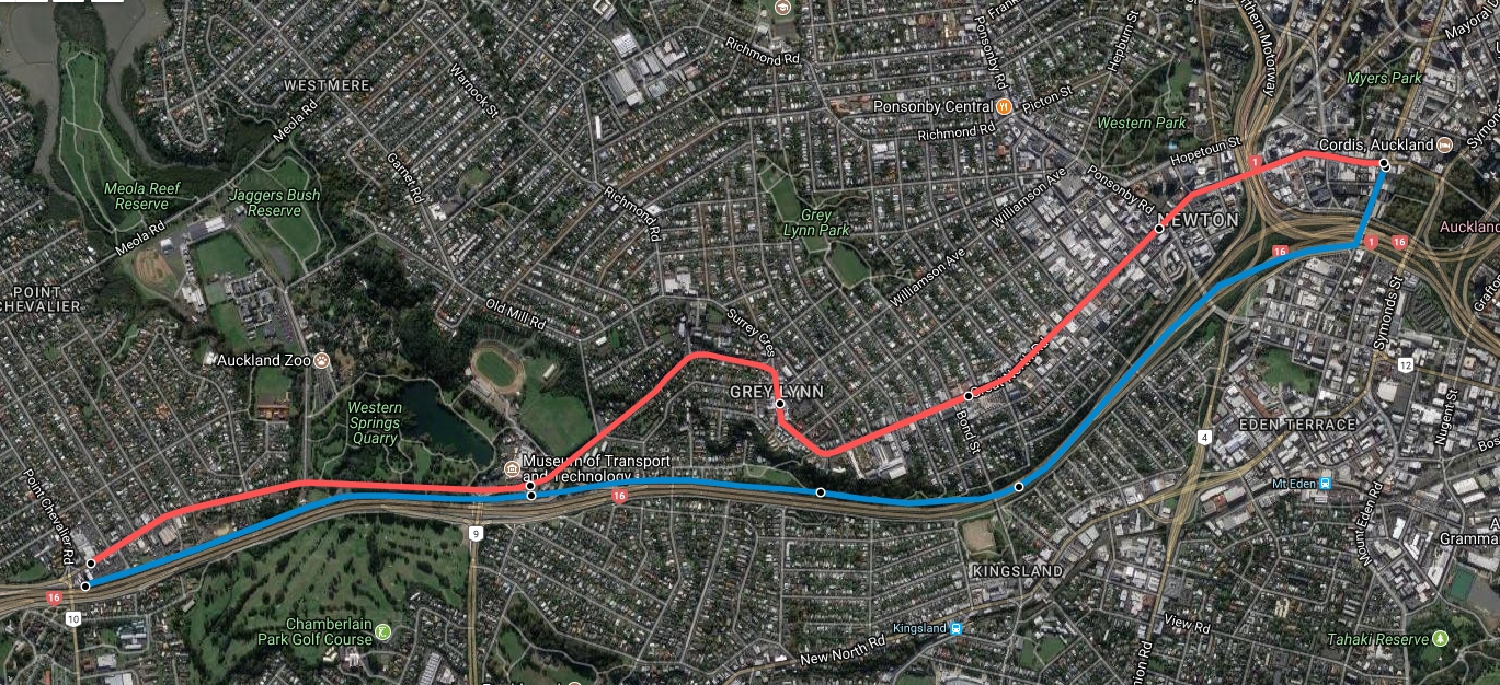
The Weekend Herald can reveal that the suburbs of Pt Chevalier, Grey Lynn, Arch Hill and Karangahape Rd are on the route being considered by the NZ Transport Agency.
The route is part of a light rail project – the modern day version of trams – from the CBD to West Auckland.
The option of taking trams off the northwestern motorway at Pt Chevalier and running them along Great North and Karangahape Rds is the third big change in as many weeks to a $10 billion public transport programme of ‘Think Big’ proportions in Auckland.
The key phrase here is that it is being considered. That the NZTA are doing this isn’t at all surprising as since taking over the delivery of Light Rail from Auckland Transport, they’ve have been reviewing most aspects of it. And in the case of the Northwest, AT had previously been looking at busway options for it. But I suspect that after ‘considering’ the options, they will most likely prefer the motorway option for light rail. So I thought I’d look at a few of the reasons why the motorway corridor might be best.
How does it integrate into the wider PT and transport network
In thinking about what corridor we use for light rail to the Northwest I can’t help but think, Why not both?
In Auckland we became accustomed to trying to have one route do everything, usually ending up doing each of those things poorly. The new bus network has helped to reset that and so as we move into a new era for PT in the city it gives us the opportunity to think more about how we develop our PT network.
To me, the primary purpose of light rail is to unlock and serve the huge growth expected in the Northwest in the coming decades. But there is also significant development occurring along Gt North Rd though Grey Lynn and it’s quickly becoming a busy and dense corridor. A corridor that’s going to need a more localised level of service than, in my opinion, we should look to provide with light rail.
Fortunately, we’ve already got a really good service that serves Gt North Rd in the 18 bus route between New Lynn and the city. That could be further enhanced by better bus lanes, stops and even buses (electric ones) as part of making Gt North Rd a great multi-modal boulevard. That would then leave Light Rail on the motorway to provide a faster, more direct service for longer distance passengers, almost like an express service if you will.
Perhaps one way to think about this issue is to think about what corridor would be best if instead of building light rail, we were building a busway?
Speed vs coverage
With all transport there’s always an inherent trade-off between speed and coverage. In this comparison, the routes are both of a fairly similar length with the motorway option coming in at around 5.1km and the Gt North Rd option 5.3km. The big difference though is the possible speed.
- Along the motorway corridor this could be up to the maximum speed of the vehicles (perhaps 80-100km/h)
- On Gt North Rd it would be the speed limit of 50km/h. In addition, given it would need to replace those more local services, there would also be an need to stop more often.
A quick estimation suggests that going via Gt North Rd could add five minutes of more to the travel time for those coming from further out, and that includes the motorway option stopping once or twice between Western Springs and Karangahape Rd, such as around Bond St. The exact amount of difference is uncertain at this stage as the route includes getting through the Western Springs interchange and the NZTA have tended to look poorly on anything that could potentially impact their motorway ramps. Of course, light rail is meant to have signal pre-emption but it’s unclear how that would work with a motorway interchange and frequent light rail services.
By comparison, light rail along the motorway corridor would likely be grade separated and so sail through the interchange.
Overall a five-minute saving over just 5kms is fairly significant and as much as possible we should try and keep Rapid Transit rapid.
Connection to the City
The final piece of the puzzle is to consider how the NW line would connect to the city centre – and as we pointed out recently, previous work on the busway stopped short of addressing that. There are two options for how this could be done.
- A second light rail corridor through the city.
- Share the Queen St corridor with the City Centre to Mangere line.
Let’s look at these
Second LRT corridor
This would most likely be by sending light rail down Pitt St, Vincent St and Albert St. The biggest issue with this is simply the cost of having to build another light rail corridor through the city. It would likely add $100 million or more to the cost of the project which could make it that much harder to actually happen. It would also likely leave us with two half-used LR corridors through the city.
There’s also the issue of what you’d do with the other city centre buses that would use Albert St (once the CRL works are completed). One of the reasons for building light rail in the first place is to help free up existing bus corridors because as public transport continues to grow, we’re going to need those corridors to run buses from places that won’t be served by our rail networks.
The Queen St corridor
Being able to use the Queen St corridor for both routes makes a lot of sense and ensures we get the most value of that investment. Some may say to just send LR along K Rd and then turn down Queen St but it’s quite likely that won’t be possible. The current plan for the City Centre to Mangere line is create an underpass of the K Rd ridge-line. As well as grade separating that intersection, it would be the location of the station and also help ease the grade at the southern end of Queen St.

Joining those two lines at Ian McKinnon Dr would allow both routes to seamlessly use the Queen St corridor.
Longer term we may eventually need a second city centre corridor but it be better to build it when we need it than trying to build both corridors upfront.
Overall I think the benefits of the motorway option will outweigh the Gt North Rd one and that the NZTA will come to that conclusion. There is also the added advantage that it won’t immediately put plans to upgrade Karangahape Rd and Gt North Rd into jeopardy

 Processing...
“light rail along the motorway corridor would likely be grade separated” – are you suggesting that LR would be raised on piers and run high above the motorway? Or dug in a tunnel below? No room for it down the middle at ground level? (that would surely be much cheaper?)
I would think the only realistic way is elevated like the new light rail system in Hawaii.
Grade separated doesn’t necessarily mean the Light Rail has to be elevated or in a tunnel. I think Matt means that Light rail would likely be grade separated along the motorway because the motorway itself is already grade separated (other roads and paths already cross the motorway on overpasses and underpasses). Thus it would be still considered grade separated even if it runs in the middle of the motorway (or indeed on the side like the Southern Line between Newmarket and Penrose) at ground level.
But Dion, it would have to be significantly grade separated if you take the plan seriously near the top of the post – you can see that the blue line for the possible track swaps from one side of the motorway to the other, and then crosses several other lanes, in order to access the Newton Gully / Symonds St area. Trying to put a LR pair of tracks through the busiest motorway junction in New Zealand is going to be a hard task, and there is no way that could happen at ground level…
Sure, along other parts of the route, running at grade could be quite possible – but for the passengers to get into the centre, there will need to be pedestrian over bridges or underpasses to get to the station. MOTAT, Grey Lynn, Kingsland etc, will all need significant route connections to the other side of the motorway, in order to get passengers arriving from both sides.
Presumably it would be something similar to the Northern Busway, running along one side of the motorway at ground level with underpasses or overbridges at the interchanges. That doesn’t sound especially difficult as there is only one motorway intechange between Point Chevalier and Newton Road.
Thanks for this well considered view Matt. My lay persons initial view about slowing down the RTN as quoted in the Herald article is somewhat validated. The West and Northwest community have been waiting a very long time for an RTN option. The rail is very good but limited as it veers too far West to be useful for a large and growing catchment.NW will contribute 25% of the regional growth in the next 15 years. Out here we need a Rapid Transit Network to be Rapid and hopefully we won’t have to wait 10 years for it.
Yes, the priority here has to be getting rapid transit for the NW residents whose commutes are of a length that research shows adds 30% to the chance of a marriage breakup (just as one example of the stress it causes.) Inner West residents (I am one) already have good PT. I know; that’s how I get around. For this reason, the motorway route must be chosen.
What I am concerned about is that the cost of constructing the NWM route will count against it. To achieve a LR route alongside the motorway will require quite a bit of excavation, which is costly. It’s also destructive of place and will create ‘serial severance’ for the communities along the motorway. Look at how much space and vegetation was taken from Pt Chev just for the Waterview Connection: https://i.imgur.com/FoPG0yR.png Taking another wide slice will have a poor urban form outcome.
Matt hasn’t gone into the alternative of instead reallocating lanes from the motorway to use for Light Rail. I think ignoring this option may put the NWM route into jeopardy, making the GNR route more likely. And I think NW residents should seriously think through whether a concerted effort to get traffic off the motorway while reallocating lanes to LR is something they would welcome, for the better end result. Bus priority all along GNR, the NWM, and the inner west route of Pt Chev Rd and Meola Rd, etc, HR shuttles out to Kumeu.
Two comments in response to that Heidi, firstly LRT in the street can indeed be very expensive, especially if it requires relocating pipes and cables from under the road, shifting around drainage and kerbs, or buying land and widening. Modifying intersections isn’t cheap either. In some cases a line along the side of a motorway corridor could be the more affordable option if long stretches of it can simply run at ground level or with a little retaining (e.g. Western springs to Newton Road).
Secondly please don’t compare a RTN corridor to the motorway junction! An LRT or BRT line needs only a strip 8-10m wide, and maybe double that at stations. Waterview has *offramps* that a bigger than the LRT would need to be. Motorways are an order of magnitude bigger and more impactful. Given the existing high impact and severance of the motorway I don’t thing the transit line alongside it would appreciably change the situation. Depending on how they do the access to stations it could even make it better with new overbridges and pedestrain links.
Thanks, Nick. I guess I need to see some construction cost comparisons, and then I can be fully on board with that side of it. Agree that the motorway impact is of a different magnitude, with the effect on all the roads leading to the ramps, as well. (And it’s the motorway impact that was so harmful). There is one way that reallocating lanes is definitely the best way though – it is the only one that will create traffic evaporation (while increasing people flow). This is important for climate change, urban form, and well, you know the rest.
The outcome for Pt Chev that would be transformative would be if GNR could be realigned to go south of the shops at the same time as the LR is going there. At least for general traffic and trucks. Maybe the 18 should remain on the existing route, in a bus and active mode street.
+1
‘HR shuttles out to Kumeu’. As well as the bus priorities to alleviate the NWM crush until NW LR progresses from dream state to rails in ground.
Might want to call Fergus on that one Linda.
The west is last on the list.
The first stage up Queen and a chunk of Dominion will take most of next electoral term. Presuming the locals don’t kill it like they have every other Dominion upgrade.
Then to Mangere.
Then to airport.
Then west. Somewhere in a third electoral term, under a Labour government since National would wait and wait and wait.
Unless the Minister has a procurement miracle in mind.
I don’t see why building two LR lines at the same time is a ‘procurement miracle’. We currently have numerous large roading projects underway around the country.
Imagine the double miracle of reallocating effort from large roading projects to multiple light rail projects. Put out a general invitation to contractors who have won roading contracts “volunteer to give it up and we’ll transfer your company to work on Light Rail, the future of transport projects, so you’ll move into the future with the competitive advantage of experience.” Chuckle.
So you want to take large roading projects from other parts of the country to fund trams in Auckland, that’s going to go down well south of the Bombay Hills or north or Orewa.
Can’t LR be built in sections so that some part of it is operating instead of waiting years and years for the entire line to be finished?
I think it will almost certainly happen like that. Mt Roskill and Te Atatu first and then Airport and Westgate as second stages, with Kumeu as a third stage for the NW LR.
All of the RONS took 5-10 years to prepare, few are an alliance (and even that on an “availability” model rather than paying a toll or a ticket), none of them involve rebuilding land for housing, none are in brownfields areas (stakeholder and litigation trench warefare), and the stand out: it’s not been done here since before World War 2.
And sure, NZSuper and the Canadians can claim they can do everything. I remember Serco saying they could build, own, and operate all of New Zealand’s prisons. And Wisconsin Rail/FayRichwhite could own and operate our entire rail system. We stopped Think Big for very good reasons. And CRL has taken 3 years of construction to get 500 metres up the road.
The Minister could well roll the dice, sign up the whole thing before his first term is up, and just hope that it all goes well. But then there’s George Street, neck deep in promises and even deeper in litigation.
The Minister would be wiser to require the industry to walk before it claims it can run.
I agree with you that these shouldn’t be rushed into. However, all of the NW route can be built in the motorway corridor so I’m not sure of any of the relevance to legal issues around Sydney light rail.
If they are going to be built sequentially I’d build NW first, as the biggest challenge in terms of resistance will be Dominion Rd.
The relevance of Sydney light rail is Dominion Road as you note, but it’s also Great North Road if they go for that option. You’d be surprised the amount of litigation AT and NZTA went through with landowners on Te Atatu interchange and widening that Waitakere Council had scheduled many years before. Ug-ly.
Dominion Road is the one with any design work and land acquisition work done, and it fits with all the downtown works, so it is first. The Te Atatu park, marine reserve, Transpower, and station land requirements aren’t to be sneezed at despite much of it being in NZTA corridor.
Hasn’t the Minister already said something about bringing forward the NW line? Not surprised if there is a further announcement in coming weeks or months.
The Minister needs to go have a chat with NZTA and stop writing cheques with his mouth that his ass can’t cash.
Given NZTA’s track record with anything that isnt a road, I’m with the Minister.
It is pleasing that you seem to be in support of light rail Linda. West Auckland has been appallingly served by previous Governments, particularly the last Government – cancelling the NW Busway would have to rank as one of the worst decisions of urban planning in Auckland’s history and it is a shame that National is now intent on criticising the project. Perhaps some of their MPs could come out to West Auckland to see what it’s like trying to get into the CBD without rapid transit options. It would be worth bringing West Auckland councillors and local board members together to lobby Auckland Transport to make interim steps to improve bus reliability from New Lynn – the 18 service is a total shambles due to the lack of bus lanes.
If light rail goes along Great North Road it will suffer from the Mt Eden bus problem. People trying to get home to the North West will be squeezing into light rail units full to the brim in the CBD that will end up mostly empty at Point Chev. There is no frequency for a fully through service that will give capacity for the short trips while being economic for the long trips.
Agree, which does lend to the “why not have both” argument. Keep the No18 bus running really well for the inner suburbs (it is arguably the best bus route outside the busway now), and add the new line in parallel for the outer suburbs and the growth areas.
In fact you could probably streamline the lanes and stops for the 18 into something really efficient, if all the other expresses and stuff were replaced with LRT and it was the only bus on the corridor. A little bit of paint and some tweaks to the stops could have it running like a rubber tyred tram line.
+1
Get all the cross town routes off of GNR too. GNR as an urban boulevard, the motorway corridor as the high speed corridor. Further into the future we can look at lrt along GNR *as well*.
P.S. did anyone see the local guy pushing a GNR route say that he thought GNR needed let, but that it shouldn’t be a catalyst for development?? Talk about having your cake and eating it too!
Agree with you all, miffy, Nick, SB. The 18 is so good they can surely start to re-humanise the GNR corridor, especially west of Pt Chevalier. It just doesn’t need to be so car-dominated, given the people-flow capacity of the 18.
+1
5mins saving per trip? Let’s play with that a wee bit …
Assume on average an LRT service runs every 10mins in both directions, from 6am to 12pm, or 18 hours per day. That’s 6 x 18 x 2 = 216 LRT trips per day. Round to 220 to make subsequent calcs easier.
Now annualise by assuming there’s 300 typical days per year. That gives 66,000 LRT trips per year. Round to 70,000 trips each saving 5mins = 350,000 mins ~= 6,000 hours.
Assume an LRT vehicle costs $300 per hour to operate. That’s $1,800,000 p.a. Over 40 years allowing for some discounting we can multiply by 20 to give an NPV saving of about $36 million.
If I have my fudge fingers right that suggests the SH16 alignment has ~$36 million head start on the GNR alignment?
Of course passenger benefits, capex, and congestion benefits also need to be included, but the OPEX savings alone appear to be non-trivial, IMO.
I think the difference could be considerably larger if you factor in the city end. A route through K Road and down into Pitt or something would be fairly tortuous, with right angle corners and various sets of lights and intersections. You can prioritise LRT of course but there is a whole lot going on there with pedestrains, cyclists, buses and traffic, I doubt you could achieve quite the same as running along the motorway, through to the K Road portal and onto the Queen St corridor.
My guess is about 20 minutes via GNR and K Road is the best you could achieve to the Aotea area. One problem being that if you replace the buses on GNR you probably have to stop six or seven times along the way at least.
While via SH16 and Queen St the first 6km would be at grade separated speeds (4.5min), the last 1km a direct run at 30km/h (2 min). Only two signalised intersections (both straight through) and one underpass between Pt Chev and Aotea. Add in three intermediate stops and you’re still only looking at ten minutes.
I guesstimate you can double your guesstimate!
Agree! Here I was simply working with numbers we had to (1) demonstrate process for estimating OPEX and (2) highlight the importance of seemingly small operating improvements.
If what you say is true (and I suspect it is given numbers of stops and intersections on GNR alignment), then yes we can double OPEX savings to ~$70 million.
That’s starting to be a significant saving, even before you count capex, decongestion, and passenger benefits that may follow from GNR alignment.
Just fit out passenger focused road trains like they do in the Australian outback instead…
What ever the option speed must be the base objective. Uber etc will find it difficult to make inroads into PT if PT is fast and efficient. Something most of our bus based system is not!
@Waspman Is Uber the enemy somehow? Excellent article, great options to consider but rideshare services have their place in delivering confidence to people that they can leave their car at home and still make it back at odd hours without busting the mortgage. Unless you’re proposing that Auckland’s PT run at 10 minute intervals all day and all night with secure surveillance at every bus stop out to Ranui…
It’s arguable that Uber has been a significant enabler in growing Auckland’s PT patronage – take bus or train to work, get a ride home or do errands that take you away from PT routes with relative ease. Apart from the remuneration or lack of it for drivers (sorry, “partners”), what your beef with Uber?
There’s a recent post on that one, Peter; if you write your question there, the conversation will be easy for people to read when looking up the subject. The relevance to this post is simply that if LR can’t compete with Uber for long stretches of this route, there will be more cars on the road, and the investment into the LR will not be providing the benefits it should.
Thanks Heidi, I’ll look for it. In an age of burgeoning use of electric vehicles, pollution will diminish as an issue. But an argument that rideshare is somehow in competition with PT, rather than complementary, deserves rebuttal. You can’t coerce return on an investment if it’s unsound in the first place – but it isn’t. Both have a place, unless ruts and judder bars make roads impassable.
Electric vehicles will get rid of most gas emissions in NZ as we have mostly renewable electricity (although not 100%). They also lower noise pollution without completely eliminating it.
However I consider the fact that I can’t walk out of my office and cross the road in a safe and timely manner as a form of pollution! Maybe self driving cars will fix this…
Electric vehicles are a long ways away from being affordable for the majority of kiwi families. I know a few people where I live in Norway who have traded in Tesla’s for conventional vehicles again, despite all the apparent advantages they have you just can’t use them like you can a traditional car.
I had a model S for a weekend it was nice, very fast, surprisingly loud inside, badly built, completely souless and I ended up buying another A6 Avant, it has more space for my dog, it can tow a trailer, I don’t need to refuel it for 1100km, it takes about 5 minutes to fill up. I really wanted to like the Tesla, but I just couldn’t. I suspect in 3-4 years time when I buy a new car electric will be vastly improved and I’ll probably buy the electric version of what I have today but right now it’s not worth the effort.
BTW my reply was to Waspman’s comment on Uber. I’m not trolling this article all by myself!
No, and I wasn’t meaning that you were. It’s often quite appropriate to take a detour in topic; do it myself. I just thought that since that post is still fresh, your input is valuable there.
Yes in an ideal world PT would be used for rapid mass transit and Uber to fill in the gaps. This is why PT needs to be as quick as possible – if Uber is quicker, people will use it, and this will cause congestion, pollution, etc.
That’s a daft idea, filling the gaps are what buses are for, uber is far to expensive for everyday transport use unless you’re wealthy. You would also require thousands of Uber’s, that’s more cars on the road which we don’t want, right?
Quite right. Active modes for the bulk, buses to fill in the gaps, cars as the luxury treats once in a while.
I agree. Make the route as direct and fast as possible, otherwise people will still drive.
Motorway alignment really should be the clear choice here. Costs less now, lower Opex, and faster. GNR can do just fine with buses especially if buslanes are improved.
A problem with having NZTA make the decision is they have a conflict of interest. They might opt for the Great North Road route to preserve their own NW motorway corridor for road widening. If we had one agency responsible for all roads and PT then they would balance benefits and costs. But in this case there is the potential for externalities.
+1
There’s a pretty good chance now that NZTA will take over management of a number of Auckland’s key arterials from Auckland Transport. AT have not been shown to be experienced in large projects.
Which one has more chance of changing their practices to take account of induced traffic, Ad?
Great question.
My bet is on NZTA: they hold the largest network levers.
Elevate the tram tracks along the motorway then you can have both. I would also build both versions, some trams would leave the motorway and head along GNR whilst the express trams would continue along it. Building a complete network is name of the game.
There will be the same debate within NZTA and HNZ – a debate that reflects the Ministers’ own thinking – about how much Wider Economic Benefits will accrue from one route or the other.
Putting rail up the motorway is the most sterile option because it does not encourage higher housing density around nodes.
Putting rail in a major arterial such as Great North Road, would enable development opportunities – including by HLC in partnership with NZTA and light rail alliance partners.
That is exactly the debate now occurring about the route for light rail to the airport: should it divert from SH20 and go through Mangere Town Centre, because that will greatly enable redevelopment opportunities for HLC and partners to generate more housing around public transport centres.
Transport has had a whole bunch more spent on it than housing in Auckland, and yet housing is where the human need is greatest.
If this government really is going to put this many billions into public transport, we need to allow the full redevelopment of whole sectors of Auckland, not just a mode of transport.
Yes, that makes sense. The problem has been the ill-conceived greenfields growth. Now that the people are located so far out, and suffering the long commutes, how do we ease their burden?
Near GNR there might be a swathe of high intensity, but I’d want to see the whole of the inner west commit to intensification before GNR is considered. NIMBY’s are alive and well, here.
Or maybe Mangere could have a spur? Still get the quickest link to the airport but also have PT to new development areas. The airport probably won’t need the same frequencies as Dominion road would so it could work…
Or a bus to the LR station.
The nodes on a rapid transit route like a NW line are the interconnects with bus routes, rather than the residential/town clusters which local routes service directly.
Good transitions from rail to road/bike/ped modes at each interconnecting node are crucial – such as Te Atatu and Carrington Rds.
I’ve always thought that the airport route should be built to allow workers to and from their employment centres and that will end up with a dedicated HR alignment at a future date, probably through the route to Otahuhu.
For LR to the NW, I think that we’ll probaby end up with an express type service, to bring the NW in closer by routing along the motorway and that at some point the 18 bus will be replaced by a local stopping services, using the Northern busway model of increasing the ridership to the point that light rail becomes necessary.
The main differences between the Northern Busway and the NW LR route are:
– the environment in which they’ve been planned (I doubt John Roughan would run the infamous elephant cartoon now)
– the demonstrated preference to utilise quality PT when available, which is down to the Northern Busway
Please God, don’t allow the first new high quality PT in Auckland for a century to be turned into a snail in the name of “redevelopment opportunities”.Fast, reliable, comfortable PT on the speediest alignment must be the priority, not just another meandering bus style route which has zero appeal to the vast majority of the population with access to cars.
I don’t quite see why GNR is seen as being so good for density around nodes. It pretty much runs parallel to the motorway so only has residential on one side, and for about one third of that northern side there is a great big park.
This doesn’t appear to justify LR taking a significantly slower route.
+1 And the GNR doesn’t offer the opportunity to reconnect suburbs with new bridges or better pedestrian/cycling amenity over the motorway, so in terms of amenity for the inner west, I’m not sure it really offers much. It’s more an image thing, I reckon. The 18 bus is actually fantastic. But light rail sounds cool.
Totally agree. It’s too big an opportunity to miss, housing and transport combined, with a side order of health for the people who benefit from the interrelated view.
I think the delay would be more around 10 minutes. There would be more stops but also significantly more traffic lights (AFAIK around 10 between Pt Chev and K’rd). Even with signal preemption giving 20sec wait times on average that’s just 3 minutes across that route. Plus the slow down/speed up after each lights, plus lower max speed.
Let’s hope NZTA can see that (plus the additional cost of relocating the services).
“On Gt North Rd it would be the speed limit of 50km/h. In addition, given it would need to replace those more local services, there would also be an need to stop more often”
I’m not sure why this is a bad thing. Stopping more often just means it’s more accessible to more people, right? Surely the idea isn’t to make the light rail hard to access? That’s my main issue with going down the motorway. It may be faster, but it’d take way more than 5 minutes extra to get to and from for the majority of westies. That said, as an occasional user of the 18 route, the frequency of bus stops is way too high. If it only takes a few minutes to walk to the next bus stop, maybe one of those bus stops is unnecessary?
Personally, I think we need to go crazy.
Have a line down the motorway.
Have another line that follows the 18 bus route until Avondale then go all the way down Blockhouse Bay Rd.
Have another line either down Ash and Rata Streets from Avondale, joining up to Great North Rd after New Lynn and go all the way down Great North Rd and Lincoln Rd.
Have another line that follows the 120 bus route from Westgate down Hobsonville Rd (perhaps following the Upper Harbour Motorway after Hobosonville), and to Constellation Drive.
Have another line from Henderson down Edmonton Rd and all the way into Te Atatu Peninsula town centre – just to add to the crazy, maybe go through the Peninsula, build a bridge to West Harbour and continue up to the line on Hobsonville Rd.
Where are we going to get the money for that? Auckland pays out billions more in taxes to central government than it gets back from it. Just dip into that. Sorted.
West Auckland has way too many cars. I keep seeing things saying Great North Rd from New Lynn to West Coast Rd is the busiest road in NZ. So, boom. RTN out west.
Making the inner part of a long route accessible isn’t always a good thing. High demand in this area can result in jam packed trains for the first bit of the route and relatively empty trains for most of it, which isn’t particularly efficient.
Better to service GNR with good quality buses.
So the North Western light rail is only for people who live in Te Atatu and beyond?
I get the need to remove congestion from the motorway. And to do that, you most certainly need rapid transport down the motorway. However, I don’t get how everyone seems to be ignoring that all the way from Point Chev to Te Atatu you’ve got the harbour on one side and a massive swamp on the other, which means you’ve got no catchment for essentially a quarter of the entire route. And the catchment from Te Atatu through to Royal Heights is also pretty limited on the northern side of the motor way due to the structure of the peninsula.
How is that, in any way, a no brainer?
Combining a frequent stop inner service and a rapid outer service on the same tracks. What could possibly go wrong …
Oops incomplete post. Meant to add:
Keep the two patterns separate with interchange between them at Pt Chev.
Rationalised GNR buses should form the inner service and LR via motorway corridor the outer.
If the GNR buses end up absolutely rammed consistently, then upgrade to LR (as a separate line). Removing current buses from further west should allow capacity increase.
No, however I would say they are the most important group of users for this route. LR from west of Te Atatu would be a step change for this area in terms of public transport, and it is an area earmarked for significant growth.
In contrast LR on GNR will not be a step change, it will just be an upgrade of an already good bus service. To me this doesn’t justify slowing down rapid transit for those living west of Te Atatu.
Running LR along GNR from Pt Chev is akin to running the Southern line along the Great South Road from Greenlane to the CBD. No one would consider this a sensible idea.
I don’t agree that it’s an already good bus service. Good by Auckland standards, sure. But only from New Lynn and only until you get to Queen St.
I just find it incredulous that living in Kelston, close to Great North Road, the section of which is one of the busiest roads in New Zealand, my public transport options are limited to: A walk of over a kilometre to the train station in Glen Eden, or an unreliable bus service that only has 4 buses per hour at peak that takes me into New Lynn.
Anyway. My argument is for a much more integrated light rail network throughout West Auckland, which is quite a bit different than either of the options that seem to be considered at the moment. So I have digressed from the start.
I was talking about the bus service between Pt Chev and the CBD as this the relevant bit. The quality of buses in Kelston is largely irrelevant as NW LR won’t go there either way.
Certainly needs to be bus priority all the way from Kelston, of course.
Build both routes, express trams continue along the motorway and the slow tram exits at Pt Chev and runs alon GNR to the city. If I’m living way out west taking a tiki tour along GNR when all I want to do is get to work would probably keep me in my car, but if there was a limited stop express tram then I’d be interested.
Surely if there is LR on the GNR route, it’s almost a foregone conclusion that they will need to use Pitt Street and Albert Street? The technical issues of trying to manoeuvre the LR vehicle around the corner from K Rd into Queen Street and somehow join up with the LR passing underneath Queen Street would seem to be pretty difficult? For this reason alone I think that the better option will be to use the motorway alignment and then join up with the Dominion Road LR line at Ian Mackinnon Drive. Cheaper and faster, even if it doesn’t provide LR service to a developing stretch of Great North Road. As others have said, the 18 bus is now of a pretty good standard, and serves Great North Road very well.
PLLLLEEAASSE Great North Road, and K Road team, I am really sure about this. And then we can continue it to New market across grafton Bridge one day also.
I disagree — there’s too much potential development from Te Atatu out that needs a speedy connection to city.
Personally I think any LRT line on GNR would be better off considered as another line that continued to PT chev peninsula or Mt Albert via Unitec on Carrington Road.
Point is: SH16 needs a rapid transit servive that is not compromised by inner section. The latter can instead be dealt with separately. That probably means buses but could mean LRT too.
LR on the motorway is a no brainer, apart from NZTA it reduces the number of stakeholder issues significantly. The majority of projects that falter, once you go through consultation process with stakeholders with vested interests (i.e Wellesley bus corridor). These costs would also be significantly lower utilising the existing motorway designation. Construction disruption would also be dramatically less, I think the impact would be reducing SH16 by 2 lanes to accommodate construction and a temporary bus lane.
via the motorway seems like a no brainer to me. otherwise people from further out wont touch it like the bus to westgate atm, takes all day. People further in have more options (active, bus).
LR via the motorway is the much better option. Faster, easier to connect to cross town bus routes (current and new ones), and redevelopment opportunities on both side of the motorway. Especially if the golf course at Chamberlin park was sold off for high density housing via Kiwibuild.
The 18 bus route is fantastic but can be improved in a big way with median bus lanes instead of kerb-side bus lanes.
However, the danger with the motorway route is that they cheapskate out on the stations. They need to make it a people friendly atmosphere, separate from the motorway using glass walls and lots of sound proofing but accessible via multiple paths for transit riders. For example, between St Lukes and Point Chev section, if there is going to be a station it should be raised to be level with the top of the cutting and have ‘flat’ bridges to each side, rather than being level with the motorway in the cutting.
Yes.
Agree on the median bus lanes!
It’s just over a hundred metres through the park from the Grey Lynn Library to that stop across from School Road. You could have a stop there with an escalator up to GNR if you’re really concerned with connecting up Grey Lynn to the system. Not sure it would be worth it but it’s an option.
Interesting idea, it would be one mother of a escalator, I think there is about a 50m vertical climb there. Still, if they can build this: https://en.wikipedia.org/wiki/Central–Mid-Levels_escalator
Yeah, that’s exactly what I was thinking of. Angel Tube Station has a twenty seven metre high escalator so I imagine two twenty-ish metre high escalators separated by a landing. I also imagine there would be a passenger concourse over the tracks/motorway possibly connecting to School Road/the North Western Cycleway. Expensive but it could be worth it if development around the area warrants it.
Interesting ideas. Better walk up catchment than if they tried to locate a station at St Lukes Rd, for sure.
In terms of PT amenity for that Western Springs area south of GNR, I also noticed that there are no bus stops along St Lukes Rd between GNR and NNR. This means the 650 bus is useless for those residents, and since it may become a frequent route next year, they’d better sort that. But tricky, with the cycle lane there.
I see value in a St Luke’s Road stop to service the Zoo/MOTAT/Auckland Cricket Ground (if Auckland Cricket finally swallow their pride and relocate to what will be far superior venue). That ground could see 20-25,000 spectators and being able to shift them out of the area quickly will be important considering the lack of hospitality in the area to help spread the crush over time as you have in Kingsland.
Definitely main stage one alignment should be the motorway for all the good reasons stated in the post & comments I’ve quickly read above. A second stage, which may come around or be warranted quicker than we think say 5-10 years after the first stage, would use Gt Nth Rd. I’ve put ideas up for this before when sort of on topic, but if have time put my edited ramblings up later.
What’s the knock on plan for the bus routes? Perhaps you’d drop the express services as light rail that starts or finishes the journey whipping along the motorway corridor past the inner suburbs would replicate them?
One of the advantages that the Gt North Rd side of Grey Lynn enjoys is that, in addition to the 18 you can also access the 110, 132, and 133 there and back again, so there are a lot of options, frequently. Assuming this remains the case, which may be untrue, then that argues in favour of a motorway option for light rail, since you don’t really need the extra capacity in Grey Lynn running along Gt North Rd (and let’s face it, if the CBD is your destination, walking is more than viable too from there).
If it follows the theme of the new network in the south vis the existing rail lines, it would be dropping all the expresses and having the suburban buses connect into the new rail stations in the suburbs.
So the West gets compromised rapid transit and the inner West gets rapid transit AND better bus services on top of it?
As a West Aucklander, this is a bad deal.
I think Nick was referring to the outer suburbs more, when he meant “having the suburban buses connected into the new rail stations in the suburbs”. I don’t think he meant new feeder buses in the inner west to overload the light rail with inner west passengers, if that’s what you thought. Obviously the express buses that go on the motorway now (125x, 132x, 133x, 151x, 171x, 172x) will be replaced by light rail with feeder networks in the west. But as Tutehanga mused, it’s possible some of the lines along the GNR (in addition to the 18, there’s the 110, 129, 132, 133, 134, 195) will be dropped too. In which case, the bus network for the inner west could drop, although there will of course be other influences to do with general rising patronage, and we will have the light rail too.
What I wonder is if they will look at doing something with zones to make it more expensive for an inner west resident to take the light rail home at peak, in order to nudge them onto the buses and keep that spot for a resident from further out.
Yes thats what I would think, except for the 195 all the rest are just old school lines that are there because there aren’t any stations at Te Atatu or Lincoln Road to transfer to the main line.
I would fully expect those to become frequent feeder routes and not run into town if an LRT or BRT line was running there. That’s what they flagged in consultation, see page 4 here: https://at.govt.nz/media/1045041/west-auckland-consultation-summary-and-decisions-report-2015.pdf
That’s hardly a change for the inner west, because they all do what the 18 does in the inner west.
Well… it would be a change if they all went. It’s the frequency of all those buses that is what’s giving us such good PT. Still, with rising patronage, maybe the 18 could just increase in frequency further.
That’s kinda what I mean, they all do the same thing as the 18 through the inner west so there is no real loss if you just have that. I suppose the frequency currently works out to a bus every 4 to 6 minutes, while the 18 is only one every 8 or 10… but you could up it a little in response.
Eh? You mean the west gets a super fast and reliable frequent rail transit line supported by a wide reaching network of frequent feeders?
Sold on the busway route, but Bond St looks to be the only viable stop between MOTAT and McKinnon. You’d be hard pressed to convince anyone to get off at that scrap of green at the bottom of Grey Lynn cliff – they may as well call it “Muggington Park”
I think they’re looking at GNR because most of the Motorway route from around Grey Lynn to Ian McKinon Drive, and across St Lukes interchange, and Carrington Rd will need to be expensive elevated bridge, or require large retaining walls and expensive property aquisition.
However the motorway route is better for all the reasons described.
I would like to see an LRT station better tied into the K’Rd CRL staion, maybe by both Dom Rd and NW LRTs running underground between the CMJ and Queen St.
Also stations directly connected directly to Bond St, School Rd, St Lukes Rd (maybe platform lengths need to be shown on the map?).
The West is already developing at a rapid pace and will continue to do so. Compromising rapid transit on the chance that inner-West NIMBYism *might* dry up in future (but they’ll get the benefits of the rapid transit systems needed by growth areas either way) is not really acceptable and won’t get commuters out of cars.
Please K road option. Who agrees with me 😉
Anthony Yo Yo does. Any relative? 🙂
Light rail arrh we using it like Heavy and then getting angry for the only parts that light rail really should be.. Please people.. lets get intelligent on this huh :-0
Heavy use of light rail is better than light use of heavy rail
(up to a point anyway)
The artist’s impression of light rail running in a trench/tunnel at the top of Queen St looks like it will be terrible for pedestrian amenity.