In just three years Auckland’s waterfront is going to look dramatically different. The completion of a $268 million suite of projects on and around Quay St will transform the area, creating a people friendly space from Silo Park through to Britomart and beyond. A report on the programme and on the changes to Quay St goes to the City Centre Advisory Board today and was reported on by the Herald on Monday. The report notes:
- Auckland Council and Auckland Transport have a long-term strategic goal to progressively reduce traffic volumes on Quay Street in the Downtown area, with an aim to enable a more pedestrian-focused waterfront. This is outlined in the City Centre Masterplan, Waterfront Plan and Downtown Framework.
- This focus allows for an increased quantity and quality of public space in the city centre, as well as safer and more pleasant spaces for the increasing number of people expected to visit Auckland’s waterfront in the coming years. In particular, there will be a pedestrian focused core between Lower Albert Street and Commerce Street where the highest volumes of pedestrians are expected.
- A critical component of traffic planning is the delivery of high quality bus facilities on Lower Albert Street and Quay Street East to allow major bus services to bring people to the Downtown area, improving connectivity with other public transport services (including trains and ferries) without entering the pedestrian focused core.
- This bus arrangement has the added benefit of increasing resilience during major events using Lower Queen Street or central Quay Street. The two bus facilities will also allow for the removal of buses and bus infrastructure from Customs Street and the numerous narrow roads in the Britomart precinct.
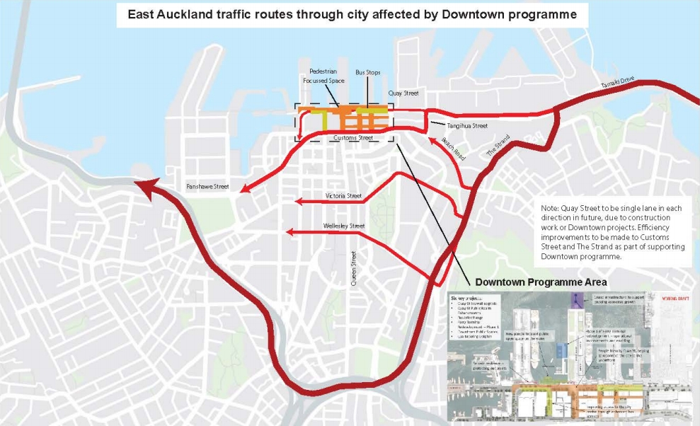
- As primary east-west connections, both Quay Street and Customs Street have historically catered for approximately 24,000 vehicles per day. Over time it is envisaged that only traffic that is accessing inner city centre locations will use these routes.
- Through-traffic would be encouraged to bypass the city centre using the motorway network. An indicative diagram for East Auckland traffic affected by the Downtown programme is shown [below]
When it comes time for the actual communications, I hope AT and council don’t just use a prettier version of this. It would be particularly silly to suggest the Wellesley St route, the core of which is intended to become a four-lane busway in the future and it would be silly to do so and then have to battle in a few years to get people using different routes again. Further, during the coming years both Wellesley St and Victoria St are going to see significant disruption thanks to the construction of the City Rail Link and the Aotea Station.
And a couple of other interesting comments.
- With the removal of bus services, it is expected that Customs Street will be able to better support traffic flows, and changes are planned around Tangihua Street to better direct Quay Street traffic to Customs Street. Similarly, Auckland Transport is working with the New Zealand Transport Agency and Ports of Auckland on opportunities to improve the operation of The Strand and Grafton Gully, to encourage this as a route for through-traffic.
- Overall it is expected that no more than 14,000 vehicles per day would use the two-lane sections of Quay Street, with additional traffic on either Customs Street, Grafton Gully or another alternative route. It is expected that the remaining Quay Street traffic will be travelling slower, which is appropriate for the busy pedestrian-focused location.
Removing bus services to improve traffic flows sounds like something out of the 1950’s. As for the traffic volumes on Quay, local access and servicing of buildings and shops along Quay St is going to be needed but I can’t help but feeling that 14,000 vehicles per day is still too high for what should be such a prime pedestrian space. The aim should probably be half of that.
The downtown projects include the seismic strengthening of the seawall, for which contractors are currently working on to locate the various underground services, all while keeping the cycleway open. But it’s the stuff above ground that people will see and there are four streams of work for this:
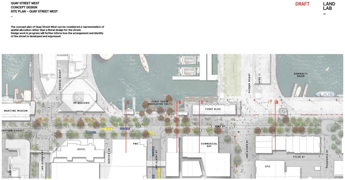
Quay Street West (Hobson to Commerce Street)
Quay St will be narrowed to two lanes with an extra lane for buses in a handful of areas, like Lower Hobson St to Lower Albert St.
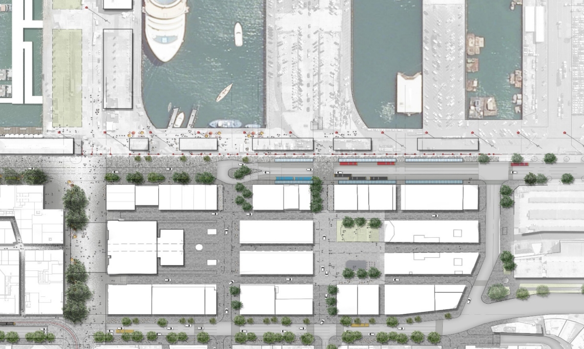
Britomart East Bus Interchange (Commerce Street to Britomart Place)
We’ve seen the bus roundabout design before and I still believe that Quay St is the wrong place for it. The key issues with it being
- It puts bus passengers at the northern edge of the city rather than being surrounded on all sides by development and shops.
- It spreads the various PT interchanges out across the area which makes transferring less ideal. It’s particularly bad for those who are mobility impaired.
The new Downtown Public Space in the ferry basin
One of the more interesting aspects to designs shown is a large new public space in the ferry basin. It is being partially paid for by the money that came from selling QE2 Square as part.
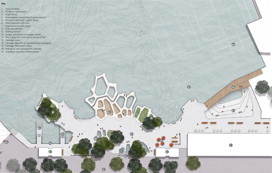

Given this appears to need piles into the Harbour, it will be interesting to see how that hard or easy the consenting is.
Galway Street (Gore Street to Commerce Street section)
Britomart’s small lanes are slowly being converted to have a greater pedestrian focus and Galway St is up next. The streetscape works will tie in with the planned new hotel on the corner of Commerce St and Galway.

On top of these projects, a further $112 million is expected to be spent in the waterfront area over the remaining seven years of the decade.
Overall there are some exciting plans although we’ll have to wait till August to see what the official plans are.

 Processing...
That so called ‘east Auckland traffic route’ through Wellesley St is interesting… you can’t legally drive on that route, it’s been a permanent bus lane only in the westbound direction for what, 15 years already?
Galway Street is still going to be a no-mans land “shared space” flooded with taxis at all hours of the day. The street is about 50 metres long, just make it peds only please!
Currently Grafton Gully is a giant snarling mess at peak with the current traffic loads. I’m not optimistic this will improve things.
It’s not supposed to. It’s supposed to disincentivise the use of Customs St as a motorway bypass.
Perhaps NZTA/AT will change the on ramp light precedence to add higher priority along that route. The reality is though, that as long as the urban route doesn’t have massive impediments to bypassing the motorway, that’s exactly what will happen.
Besides, peak travelers are also the ones who’re most likely to be able to switch to PT.
Exactly.
During peak the opposite of induced demand will see Grafton Gully volumes decline. Outside of peak it is already too fast along Quay Street, and it is definitely used as a rat run through town for people headed west or vice versa.
Quite apart from the number of traffic lanes, I would like to see Quay Street slowed right down through the areas of high pedestrian usage. Say 30 km/hr from Commerce to Lower Hobson.
How, though? Grafton Gully is how you get to the NW and SH1. That traffic can’t go anywhere else unless they rat-run somewhere else. Now you’re adding more traffic to the mix, the argument is that it will cause less traffic? If people had viable options for avoiding congestion, the current state of Grafton should mean they’d be doing it already. Unless you drive into the CBD, there’s no other way to get one SH1 northbound or SH16. There’s no alternative to ‘induced demand’ for those commuters. And the Quay St SH1 traffic added into the mix is going to mean less traffic?
Also, Grafton Gulley isn’t that much of a rat-run given it’s 1) the entrance to three motorways and 2) often totally congested at peak. It’s more likely that other local traffic (e.g. Newmarket, Parnell, CBD) is from traffic trying to avoid taking 20 minutes to get up the hill, where SH1 and SH16 traffic merge into one lane.
The last thing I would want is SH16 commuters getting off at Pt Chev where there’s free kerb-side parking. But isn’t this the sort of thing drivers might do in the “traffic evaporation” effect that we’re talking about? Come as far as they can without paying for parking, and then take the excellent frequent buses?
I’m not saying it gives a good experience; the commute would be long. But is it what commuters would start doing if the cbd becomes more congested?
Back in the 1960’s my Grandfather used to drive from Blockhouse Bay and then park up by Western park in Hepburn St and then get the bus to Wellesley St to were the lane is now when they doing the new Aotea Station Entrance Because there was no parking in that building that use to be there and he didn’t like driving in the city centre also
I think what Sock puppet is saying with “During peak the opposite of induced demand will see Grafton Gully volumes decline.” is in general traffic will decline in the CBD due to reducing general traffic access across & throughput. ie more will take a bus, cycle, train, LRT etc. The Grafton Gully motorway should be encouraged as much as possible to be used for through traffic to/from Tamaki Dr/Parnell. Ideally Quay/Customs should only be for local access general traffic wise.
The redevelopment of Quay Street also needs to include the installation of light rail tracks along lower Hobson Street, Quay Street and lower Queen Street to Customs Street to create a loop around the block connecting with the proposed line along Fanshaw Street which will link the Wynyard Quarter and redeveloped waterfront area near the ferry terminal with a route which could be operated by the Dockline heritage tram.
Installing the light rail tracks now on Quay Street will also enable a future extension onwards east along the waterfront along Tamaki Drive to St Heliers Bay.
Queens wharf was supposed to be pedestrian friendly and to start with it was. But ever so slowly it became a road, a bus terminal, a taxi stand and anything but friendly to pedestrians.
Quite right – it’s a shocker.
I totally agree – ‘the people’s wharf’ became a carpark
“Orakei councillor Desley Simpson said reducing the number of lanes on Quay St would create a bottleneck.
The key issue, she said, was to provide an alternative east-west route for through traffic before Quay St is narrowed.”
I thought we spent a few hundred million on the CMJ a few years back to do exactly that? Surprising it has taken AT so long to reclaim the local streets once the motorway route was in.
Same old, same old, eh? Like the NW motorway, which was going to remove traffic from Great North Rd… but now we’ve got six lanes of traffic on GNR on the Waterview side of Pt Chev, with no space for a footpath next to a consented 62-apartment development.
Which bit of induced traffic is so hard for Simpson to understand?
Why isn’t Mayoral Drive emphasised on that map? That is the first Queen St bypass the city sacrificed many buildings and streets to for traffic, yet has yet to calm Queen St to take the dividend… many decades have passed.
Then yes there is the loss of the verdant Grafton Gully to this god, yet again we haven’t liberated the Queen St valley in its stead…
Now is the hour. Clear it out to reduce driving demand in the city centre overall, this will reduce pointless driving and improve essential movements of people and goods on all modes.
+1 Should be done yesterday. All this cross traffic flow etc will work so much better with this step done as well.
As much as Desley speaks for the very me centric Maserati driving Mike Hosking types of this world, which I loathe, she does have a point. There is a ton of commuters from East Auckland, be it the bays or GI who by way of Tamaki Drive make their way to the city or just beyond who rely on Quay Street.
I am assuming somehow Customs Street is going to be that new thoroughfare?
If someone is coming to the CBD I’m not sure why they need a thoroughfare. There are plenty of PT options from the east and if people are determined to drive then I’m not really sure they are entitled to quick and easy access through the most densely packed place in the country just to get to their carpark.
If they are travelling to the other side of the CBD then a bypass was built for them 11 years ago.
That bypass takes them to the North Shore but not to Nelson St. / Western Bays.
Sorry, I should clarify by other side of the CBD I meant beyond the CBD, so North Shore and Western Bays.
While you are correct that those going across to the Western Bays can’t easily use Grafton Gully, I’m not convinced the numbers going from the Eastern Bays to the Western Bays justifies anything like the capacity we currently have on Quay St and Customs St. I also don’t see why they would be higher priority than the tens of thousands of pedestrians in the CBD.
Glendowie services stop at 7:00pm on Saturdays and only start at 6:30am on weekdays. The New Network managed to remove about four hours of running time from the Glendowie bus network, which now no longer hooks up to St Heliers so you can’t take a Tamaki Link bus without being stranded in St Heliers. Yep, definitely an improvement. Can’t figure out why people from Glendowie aren’t taking the bus, no easy answers there at all!
I take it you are referring to the 783, if so that is a very small portion of the eastern suburbs (around Riddell Rd) that doesn’t have coverage after 7pm on Sat. Most of that route overlaps others that do run later.
Either way those off-peak times you mention are not really when there is an issue driving through the CBD even with reduced vehicle capacity, so I can’t see why it would stand in the way of reducing capacity on Quay St.
Haven’t you heard, AT only really care about 7am-7pm.
But yeah, humor aside, I find it crazy how “all-day” routes finish as early as 17:30 or as late as 00:20 based on… no logical pattern at all. Who makes the call on these things? Why are they not based off patronage/other factors such as i.e.: are their alternative routes nearby. Similarly in the morning, services starting as early as 04:28, meanwhile some other areas don’t even start until 07:00 in the morning, meaning you can’t make it to work in time for a 07:00 start. The planners just seem to throw numbers on a spreadsheet at random and there is no proper logic or research applied.
Peter – do you have any examples of routes where the service with higher patronage finishes early while the route with lower patronage finishes later? Also do you have any examples of routes with poor hours that do not have other routes nearby?
Through traffic will divert around the CBD if it doesn’t have to wait for 10 minutes at the stupid ramp signals NZTA has on the Grafton to Northern ramp.
There’s now almost more traffic now from SH16 (waterview tunnel) plus Grafton gully traffic to make a case for moving the lights to SH1 instead!… yep, totally agree, these on-ramp lights are ill-conceived, without taking into account what’s happening in the city. NZTA only cares about motorways.
The Roads and Streets Framework – approved by the AT board last year – is supposed to govern designs like this one. Removing bus services to assist traffic flow in this area is contrary to the place and movement balance requirements laid out in the RASF.
Yet another example of AT saying one thing and going ahead with a car-focused design anyway.
AT, go look your Vision Statement. You’re supposed to have worked out your internal frictions by now. and be working together as a team. Who in AT is holding this up, and why are they still employed?
I know that some people high up in the AT strategy department are now pushing for a review of the Roads & Streets framework. And not because they feel it needs more emphasis on walking, cycling and PT…
and not because it’s been shown to fail. They haven’t given it a chance. Only because it encroaches on their cars-first mindset. That very mindset that Lester Levy describes as: “car dependency, perhaps Auckland’s most ominous and least confronted problem from a transport perspective.” And all hiding behind concern for “financial implications” while they impoverish Aucklanders with their continued multi-billion dollar spending on extra roading capacity.
Levy and Ellison, get the car-dependents out of AT. They are the “most ominous and least confronted problem”.
Is the building in that bottom picture on fire?
The architect used aluminium composite cladding.
Black humour. The name above the door says it all.
While it’s hard to imagine scale with the supplied drawings, to me it looks like the walkways over the waterfront are a bad idea. It looks like a great place for hooligans to cause trouble, or drunk people to fall to their deaths – With or without the compulsory ugly safety rails.
Do I have a better idea? Nope, but why do we even need to encroach into the harbour?
The bus roundabout also causes issues (which we know are not yet resolved) for where the Quay Street bikeway goes in that section. Buses take a huge space to turn around.
To not interrupt the bikeway, it (or the pedestrians) would seem to need to go behind the red fence, But it’s very difficult to keep pedestrians (or people on bikes) away from desire lines, so this makes it problematic for both groups as it risks causing cross-over movements and/or walking and cycling the wrong space. if they go with the bus roundabout, how they deal with this issue will be crucial.
That bus roundabout is absolutely retarded. Who ever came up with that is a idiot. You are essentially using up two lanes of road for a one-way stream of buses.Halve your capacity for not particular good reason.
And leaving Customs st a 4 lane traffic jam, pollution trap that thousands of pedestrians have to cross. Quay street might be nice to visit, but customs wont.
A short one way pair would probably work better with half the space. Of course you would have to spread the traffic between Quay and Customs.
I understand your sentiment but a one way pair would be a disaster, consider the amount of new traffic that would be forced to filter between the two to access the city. Then consider lower Albert is supposed to be a bus interchange and Queen St a public square, you’d push all those trips through the middle of Britomart.
While there might be 24,000 vehicle trips a day (total, both ways?_, my guess is at least half of that is just commuters and service vehicles getting in and out of downtown. Sounds like you are focused only on through traffic from end to end.
What new traffic? It will be existing cars circulating. It will be worse than current for cars either way. As long as the buses don’t get stuck, who cares about the cars. And I couldn’t care less about cars. You want to totally discourage cars in the CBD, but it is all about the strategy you use. AC/AT strategy is just make it worse for everyone, except the few visitors that want to go look at the water.
Three lanes each way with smaller/narrow intersections. 1 kerbside lane for buses to loop around with some indented bus stops surrounding britomart and 2 lanes for cars to get to wherever. All the other space (2-3 lanes) can be given to footpath and public space and what not. Force cars to loop around the long way or avoid the that area altogether and use PT. One way roads are far easier to manage from a traffic light perspective and will maximise traffic throughput AND maximise public space.
The current proposal still leaves way too much valuable road space still in the hands of cars and inefficient bus routes. It reeks of compromise with bad outcomes for almost everyone (zero strategy). Really, really poor use of space. Still massive intersections. Good bye cycle lanes. Customs St will still be crap for pedestrians. Lots of road space still being used by cars but the phasing will mean you don’t get much cars through anyway.
Existing cars circulating further is new traffic. Same cars going twice as far around downtown is twice the traffic.
The traffic that currently drives eastbound on Customs St, to access the streets of the CBD could be forced onto Quay St then to filter through Britomart to make the same trip. That is indeed new traffic pushed through Britomart to get from Quay to town. If not filtering through the little lanes then drive the length of the waterfront to Tangihua St, then drive back along Beach and Customs? What is the sense in doubling VKT, doubling traffic, in the area where you are trying to reduce it If you can go both ways on Customs that doesn’t happen.
Note there is actually very little of anything on Quay St, basically all the driveways, loading docks, buildings and activity of the downtown area are a block or more back from the water edge. If you’re not concerned with providing capacity for through traffic there is little need to be on Quay at all.
I don’t care about car capacity at all, which is why I have no care for a one way couplet whose only purpose is to reduce accessibility in favour of throughput.
Keeping a two way Customs is ideal for accessiblity to the various roads and side streets downtown. If you are not concerned with capacity or speed there is no reason to recreate the Nelson-Hobson place nightmare on the downtown waterfront.
How many routes is this new bus exchange going to cater to?
I guess the 27, 72X, 70, 321, Tamaki Link, 762, (774, 775 peak only buses). So busy ones are the 27 Mt Eden Rd, 70 Botany & Tamaki Link ones. Rest are sort of 30min type routes unless express or peak time – quick looks they – most are 15mins then. So flip pretty busy by the looks in peak.
See the central city NN bus map, shows quite clear unless they change it around again, but would suspect be pretty much the same. InnerLink, 755 just along Customs St.
re the Britomart East Bus Interchange Matt L. Where do you suggest is a better place? I can’t think of any other solution bar a mega underground station or something.
I’ve suggested then fiddled around a bit trying to see if something over west in the old Farmers carpark kind of area would work. Sort of does but would involve all/most of the busses coming all the way over through Customs St, congesting Fanshaw, through a number of sets of lights, winding routes and such even if it wasn’t expensive. If Customs was somehow virtually car free may work OK?
I think it’s not actually too bad this spot if nice and walkable to Ferries, Britomart, Western & Northern buses, Light rail/City Link.
ps can we all stop saying the “key thing is” etc when we are talking about “Quay St” 😉
We’re not saying it, Grant. We’re tapping it out on our… keys.
At least things are better without John Key being prime minister.
Qui?
Am I the only person here that thinks it is more than slightly obscene that $230 million is being spent on Quay St in central Auckland, making nice places for pedestrians – while South Auckland has none of this money spent? Isn’t this exactly what people in Manukau City feared would happen when the Auckland “super” city was formulated?
That was always the intention. To spend up large in the CBD and charge the cost to the outer areas. They are only just getting started.
Manukau City getting a major make over too. People complained from the north when the Mnk train station etc was built. Thousands visit & live near the CBD/waterfront area.
What, would you rather have Quay Street fall into the sea? $30+m is ring fenced from the sale of the square too.
Well, if it fell into the sea, at least it would stop excessive car use, and create an interesting lunchtime playground. $230 million IS obscene.
$230m is obscene? For a bus terminal for half of north shore buses, all nw buses, all eastern buses, upgraded ferry terminal for all routes, preventing structural failure on a major utilities corridor, and using ring fenced funds to replace public space?
Seems like great value to me with benefits for people from all over Auckland.
+1
$60m of the funding for this is from the City Centre Targeted Rate, come back with your moaning when you are rated directly for stuff that serves the whole region… seriously, the city centre is taxed thrice; nationally, regionally, and locally, and y’all kvetch about it.
Most of this spending is on stuff that anywhere is else considered a national cost, or at least a regional one, only the city centre is also taxed directly… y’all use it too.
Shrug. See that flashback Saturday post — https://www.greaterauckland.org.nz/2018/07/07/flashback-saturday-want-lower-rates-cut-back-on-urban-sprawl/
I’d love to see that graph for the city centre.
What I would like to know is who is the clown that has redesigned the berths for the ferries ? . Looking at the way they are set up there is no shelter for the passengers getting on/off the boats and if those pontoons are stuck out in the entrance AT will be spending a fortune on repairs on them especially during the winter months as they have had too do next to the Hilton and pier 2 . And will they handle all the passengers going to Waiheke during the summer months ?
Maybe someone should let the designers know they need to take into account local conditions, passenger capacity and amenity. AMAZING that they haven’t. Clowns alright. Do you want to call them or should I?
The idea that people will want to sit on a set of terraces stepping down to the water directly behind a newly positioned ferry berth is just nuts, – the ferries are noisy, smelly and generally everything you do not want to see close up while you are “taking in the harbour”
Well sitting several stories above Quay Street it would be nice to have a pedestrian area outside my door…. but it seems a bit dumb to move traffic from one congested part of the CBD to another congested part of the CBD… traffic will find a way and moving cross town traffic on the motorway is just dumb.. especially when Wynyard quarter is filling up and people need to get to work there… or had AT forgotten about the 1,000s of jobs being created just north west of their new digs??
Quay St is used by the Eastern Suburbs drives (and think Panmure and GI here as well) as an efficient way to get to the motorway – cos it is the shortest distance… Otherwise its just a dog leg on congested suburban streets… yay Auckland… topographically annoying in every respect…
You may find it actually improves flow by the simplification of road routes and light phases etc. mainly though; rom the post: “With the removal of bus services, it is expected that Customs Street will be able to better support traffic flows, and changes are planned around Tangihua Street to better direct Quay Street traffic to Customs Street.“
*from the post
The new ‘Downtown Public Space’ in the ferry basin looks like ‘design wank’ to me ie something that appears good on paper (to some) but will be totally impractical in the real world. I presume the nets and mesh are there to catch the kids who fall?
Can someone remind me of what the cost of undergrounding Quay St (as once mooted by Ludo) was going to be? I remember at the time I baulked at the cost, but given the alternative I’m now thinking it might be money well spent. Funnelling vehicles off Quay St is just going to create even more congestion on surrounding streets – but that’s probably the plan, right?