Today is the latest Auckland Transport board meeting and as I do, I’ve been through the board papers to find the interesting bits.
Closed Session
There’s quite a bit in the closed session this meeting. Some of the items for decision/approval include:
- Matakana Link Road – Presumably this is AT staff asking the board to approve a 50km/h urban road that’s more expensive per km than most motorway projects.
- ETCS – For those unfamiliar with the term, this is the signalling system used on our rail network. It is unclear what this item on the list will specifically refer to though
- Speed Management Update – Hopefully this will see something finally being done to address Auckland and AT’s woeful record on safety.
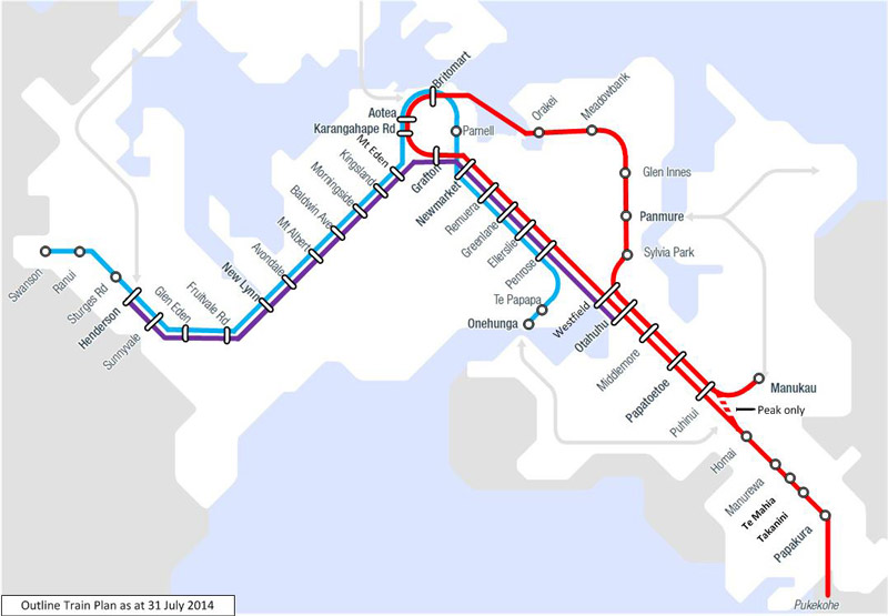
- Revised Train Plan After Opening of CRL – There have been various versions floating around of how trains will run once the CRL is complete but at a high-level, this seems to be the preferred option. There would be extra peak services layered on top of this, some of those western line trains would need to terminate at Newmarket and the purple line would be three trains per hour. Presumably AT are looking to change this. Ideally they’d drop the infrequent and wasteful purple line and put that resource into higher frequencies on the main lines.
- National Ticketing Programme Update – This was on the last agenda too and relates to a new nationwide ticketing system that is eventually meant to replace HOP
- CRL Project – I wonder what decisions AT will be making over the CRL?
Business Report
These are just the items from the report that stood out that we haven’t covered before. They’re in the order they appear in the report.
AT HOP
Over the last weekend ATs HOP website was upgraded. The report notes this was to upgrade the capacity of the system as usage had outstripped original forecasts.
CCTV Analytics
I’ve included the full text below
Pedestrian Analytics is an area of interest for both Auckland Transport and Auckland Council. To build capability in this field, a Proof of Concept was initiated to count pedestrians at the Customs Street – Queen Street intersection. In this test scenario, it will count pedestrians coming from the top right corner of the camera view to the bottom left corner.
Meanwhile, detection of stationary vehicles on the Quay Street cycleway is being developed. It will allow detection of vehicles stopped in the cycleway and alert the operators. The Parking Enforcement team will then be able to analyse the data for infringement purposes.
A total of 676 CCTV analogue cameras across 55 sites in the Rail and Bus network have been replaced over the past six months. The bus network is now complete. The rail network CCTV replacement is 95% complete, with 21 cameras remaining at 2 locations (i.e. rail overhead power isolation is required to safely replace the cameras) – this work is scheduled to take place over Queen’s Birthday weekend (the first weekend in June). Disposal of the end-of-life analogue cameras and equipment commenced in May. The Camera Record Database is being updated in conjunction with a project to make the records usable by support and maintenance teams

Northern Busway Extension
The consenting design for the Rosedale busway station is likely to be finished in July with consent being sought in October.
Parnell Station
Train users may have noticed the new path from the citybound platform to Nichols Lane taking shape. It is due for completion in June. Work has also been going on to complete the platforms and that is due to finish in July. Gates will be installed at the station.
AMETI
AT have had three appeals against the consent for the Panmure to Pakuranga section of the Eastern Busway and say a hearing is due for July 16. They’re also progressing with the design and consenting parts of the process and say construction is due to start in early 2019.
They also say they’re working on the remaining sections through to Botany they’re targeting lodging consent for the Botany interchange aspect in mid-2019.
Network Optimisation
AT say they and the NZTA have developed a terms of reference for a network optimisation project focused on improving the movement of people and goods. They say the project will include place as a key consideration which is good. It will be interesting to see what comes out of it.
Road Safety
Along with releasing the damning report on safety, below is a list of things AT say they’re doing to improve things. I assume the first one relates to the item in the closed session.
- New Speed Management Plan tasks are underway, including expanding the scope of investigation work to do more in a shorter time. A board paper is being prepared to outline the planned programme and highlight risks.
- Discussions underway with Ministry of Transport (MoT), the NZ Transport Agency and New Zealand Police regarding legislative changes requires for setting of speed limits and options for safety camera enforcement.
- Tenders for the Road Safety Programme Business Case request for proposal have been received and are currently being evaluated
- Road Safety Summit was held on 9 April and included discussions around walking and cycling, speed management, funding and rule changes, design, technology and managing community resistance to change. A new National Road Safety Strategy is being developed and is due for finalising in late 2019. AT will be consulted on this.
- Tamaki Makaurau Road Safety Auckland partnership planning continued.
Whangaparaoa Road Dynamic Lane
AT say the early indications from the PM peak use of dynamic lanes on Whangaparoa Rd are 1½ to 4½ minutes per vehicle. I wonder how much that eats into the expected befits of Penlink?
There’s plenty more in the report, anything you’ve noticed?

 Processing...
I hope they talk about the woeful scandal that is the red light camera debacle.
Do tell.
I’d imagine he’s referring to the red light running culture that AT has nurtured through not using the expensive red light cameras: https://i.stuff.co.nz/auckland/104164423/auckland-councils-red-light-cameras-havent-worked-for-years
Woeful because this nurturing of the culture has resulted in deaths and serious injuries.
Of course the ones installed 10 years ago aren’t working. They are beyond outdated.
AT presumably can pay for new cameras, but only the police can operate them. AFAIK cameras are operated by the Police because they are the only ones that can issue tickets for moving violations. The police have enough on their plate than having to go through hours of footage trying to ensure the tickets are correctly issued and save their staff being tied up for days in court over tickets being challenged.
Not really AT’s fault if the Police don’t want to enforce, but I can understand why the police don’t want to either.
AT issues tickets when vehicles move through a T3/2 lane. North Shore City got the relevant act changed so they could issue enforcement notices on Onewa Road a decade ago – so I think this is a lame excuse.
I have many times in discussions with AT said I will contract to offer red light and transit lane enforcement services. As well as being a “good thing” this would be a very profitable business for anyone fortunate enough to take on such a contract given the level of infringement.
I’d happily go through hours of footage knowing every time the lights change – ka ching – ka ching – ka ching
There is of course a wider AT cultural resistance to enforcement which I have failed to fathom. Why do they not enforce the laws about parking all over the footpaths, for example? Again, it would be lucrative until the law starts being followed again.
Parnell Station seems a bit stranded from train services compared to now
I know that the “purple line” doesn’t appeal to the PT purists, but I can see there is a decent logic on having the line – not least give the very significant number of pax travelling from the west to Newmarket. Yes, I know that there would be the opportunity to improve frequencies on the other lines, but that opportunity will come anyway with the new stock being ordered. In any event, once frequency gets to 10 min services, the advantages of improving frequency are surely mainly about capacity, and much less to do with convenience. Whereas directly linking the west with the South is ALL about convenience.
The much bigger issue in my view is that the new “southern” line doubles back on itself. I can see this leading to endless confusion as to which direction passengers should best travel, and confusion also having two “branches” of the same line where they previously had two names (“Southern” and “Eastern”).
The obvious solution is to link the Western Line with the Southern Line, and the Eastern Line with the Onehunga Line. What’s the problem with doing that – there must be one, given that they’ve consciously avoided doing so?
I agree, that red line is pretty confusing
We don’t’ know what confusing is until we look at a London metro map. Don’t really like the Purple line, blue would need to split between Otahuhu/Newmarket or somewhere and Onehunga confusing things as the frequency can’t be handled at Onehunga. The interesting thing is the south facing dotted line from Manukau.
South facing dotted line will never happen. Many dead revisions since past.
Why do you say never? It is only Kiwi Rail stopping it. In a few years the quarry will be filled in. If someone gave KiwiRail the money they could move there container operations to the quarry side at Wiri.
In case people are getting confused here. . .
That south-facing dotted-line is merely an alternative option for Eastern trains to run on to Papakura (as they used to), instead of only to Manukau (as they do at present).
It does not require the south-facing link from the Manukau branch to be built. It does not require any new infrastructure at all.
People are confused and have been for some time. The formation, bridge clearance and turnout locations for a southern Manukau link, have been in place for many years now, calling to people who wish to believe that a direct link from Manukau to Papakura is a good or useful thing and that the POAL Wiri Inland Port is therefore and by comparison, not as good or useful a thing. It is no accident that such a link was never completed. There is no such a service that would use it that supersedes the need for the Wiri freight facility and indeed, for the time being they are very much mutually exclusive.
And the school/hospital traffic to/from Grafton.
This is a operational diagram, I suspect the actual train map will have a different colour for each line with an overlap in the CRL from Britomart to say Grafton, it wouldn’t make any sense for a train leaving Manukau to have Papakura displaying as it’s destination.
While I have no doubt the West-South service would be used I doubt it would be used by enough people to justify tying up six $8 million EMU’s running. If my memory serves me right about 10 – 15 % of Western line passengers are going to Newmarket or further south, this is less than one carriage on a 6-car EMU set, even a 3-car EMU is going to have pretty light loadings.
So are you saying the destination displayed on the train will not be the real destination, and anyone going from say Greenlane to Meadowbank would need to know not to get off that train and change because its actually the one train?
Yes. It’s not perfect but it’s a lot better than having both northbound and southbound red line services at say Puhinui showing Papakura as their destination.
This is how it is done in Melbourne, a train will say City Loop as its destination, however as it enters the loop it’s destination will change to say Glen Waverley so passengers at City Loop stations know this service will run all the way to Glen Waverley.
Jezza that’s not quite right regarding Melbourne. In Melbourne all lines stop and start at flinders St station. A train will say ‘city loop’ if it passes through the loop before terminating at Flinders, or ‘Flinders St’ if it goes their first.
The lines and destinations change at Flinders Street. You can often assume that a line will continue through the loop after Flinders St, but this sometimes doesn’t happen. It’s quite confusing a lot of the time, and not something we should replicate.
While you are correct that all services ‘terminate’ at Flinders St most in reality loop back to where they came from. The displays in the City Loop stations will say where the train is ultimately going not just Flinders St, it gets a bit confusing when you get to Flinders St and wait 7 minutes because the train is not ready to depart on its next trip.
I agree Melbourne is not one to copy, but it is infinitely more sensible than having a northbound train at Papatoetoe that has Papakura as it’s destination.
That’s how it was done in Auckland up until July 2003.. do people have short memories??? The trains ran Papakura-Papakura with a brief stop at Auckland (now the Strand) but clearly a northbound train at Papatoetoe didn’t have Papakura on its destination board!
But this is even more confusing since there isn’t one obvious station to transition (Aotea maybe?).
Is it going to be called one line or two?
If it is two, where does the train change from being a southern line train to an eastern line train? Or can a train be both a southern and eastern line train for part of its journey?
If it is one, its a pretty long and confusing line that repeats back over itself for a section of its journey (but not the entire end section). And it makes our rapid network look pretty crap again – just 3 lines with one of them being almost a complete overlap of the other two.
For a train that has departed Manukau it might say Grafton via Panmure so people would know which way through the CRL it was going. They would likely change the display approaching Britomart to say Papakura and maybe make an announcement on the train so that passengers knew they didn’t actually need to transfer.
There are plenty of other cities around the world that do similar.
This is the Perth approach (http://maps-perth.com/train-map-perth) where the through-routed trains are designated as two separate lines, changing in the CBD.
So lets say they split the red line into two (southern and eastern), and lets say the split was at Aotea, doesn’t it look like you need to change trains to get from say Grafton to Britomart when in fact you don’t? I’ve never seen this before overseas, is it an Aus/NZ thing?
And then there is also the little dashed peak only part near Manukau to confuse things further.
That’s what they do here in Perth. Every train city-bound will have PERTH on their display but as soon as they arrive in Perth it changes to the end of the line destination. Its not as confusing as you seem to think. People are smart, they will adapt.
I wonder if the trains have more space on the displays to write route out better a “Papakura via Panmure & City Stations” would be fine to use. or “Papakura via Panmure & City Ctr” etc?
The Sydney system has a range of trains that change as they approach the city loop.
Most of the time it is quicker to change at Central, rather than going around the loop, even though it might be a single seat journey, which is what I normally do, using a trip planner to do the hard work of figuring out the quickest route. (Rational actor, to optimise for time, which is what I value.) An example of this journey is:
https://transportnsw.info/trip#/?wSpeed=4&wDuration=20&itMode=walk&routeFilter=time&train&bus&ferry&lightRail&coach&schoolBus=false&accessible=false&arrDep=dep&opalOnly=false&from=10101417&to=10101210&dateTime=201805291530
I’d probably take the 1 transfer option.
I go the wrong way round the loop on average once per (occasional) visit to Sydney, but it doesn’t matter much because I still get to my stop (invariably somewhere north of Central).
It sounds like the Auckland routing is going to be more efficient with less redundancy, so can we expect to see confused international travellers looping back and forth on a fruitless search for Grafton or Mt Eden stations…?
A lot more than 10% of western customers go to Grafton, Newmarket, or further south. More than 30% I reckon. Purple trains directly serve them. Granted, Aotea will munch some of the Grafton traffic, but by no mean all (the Grafton area is a major destination with Hospital, Grafton campus, and new engineering Khyber campus). Disclaimer: I am a greedy west-south commuter 😉
It’s higher if you include Grafton but nowhere near 30 %. The reason I didn’t include Grafton is that I suspect the majority of people are transferring onto buses here, I don’t have any to confirm this though.
I think this route will eventually make a lot of sense but I don’t think it is good use of trains from opening day on the CRL especially if there is overcrowding on other services. Bear in mind it will still be possible to get to all of these destinations, and for many it will be no slower given the crosstown train is only going to run every 20 mins.
People travelling west to Newmarket are small in scheme of things, especially post-CRL. I’d suggest replacing purple line with the NNR frequent, which was redirected to Newmarket rather than city post-CRL.
That way rail rolling stock is freed to service the really big demands to city centre.
Swanson to Pukekohe as a single trip magnifies risks associated with crew displacement in disruptions and makes poor use of the allowable crew hours between breaks and within shifts. Swanson to Manukau and Papakura to Onehunga is a better alternative to consider. Manukau via Newmarket and Papakura via Panmure are other variations to look at if the can be made to overcome the contrary geography around junctions. Best to keep east/east and west/west.
Yet more delays on the Eastern Busway.
Construction was due to start late this year on the Panmure to Pakuranga busway and bridge.
(https://at.govt.nz/projects-roadworks/ameti-eastern-busway/)
Yes that AT page definitely says “Late 2018 – Panmure to Pakuranga construction starts.” Surely they factored in time for appeals, so any idea anyone why there’s yet another delay?
There is a bit more detail in the board report, the delay is for additional months of archaeological studies at the Pa site just on Panmure side of existing bridge due to high volume of finds in the dig so far. Although I can understand the reason behind the delay, we are so keen to see this project commence, let alone finish.
I do wonder if the delay in delivery of EB1 is hindering the lack of progress on promises to redevelop Pakuranga Plaza. We urgently need certainty on Reeves Rd flyover and Pakuranga Bus Stataion then an accelerated build programe. Traffic is going to be really nasty for a good few years while the construction is ongoing so lets just get it done. please.
I’d be guessing the CRL discussion might be around the 3 month+ delay to C3 main tunnels and stations thus also opening day and an increase in costs.
I travel from Papakura to Britomart every day. Don’t tell me there are two additional stations and a longer route and I’m now going to have to wait for conflicting traffic at Newmarket AND Mt Eden). I thought CRL was supposed to speed up my journey!
Aotea will be the central station once the CRL, people who work closer to Britomart will of course still use it though. Mt Eden will be a flying junction and there will be fewer movements through Newmarket than there are today and fewer trains changing direction there. You also will no longer have to crawl around the Vector curve.
It will speed up most people’s journeys, not everyone’s.
Living between Puhinui and Otahuhu stations will be great if you are heading to the city.
One possible advantage of the purple line directly connecting the Western and Southern Lines (especially given that the CRL is about 6 years away) is that it would allow an increase in capacity across the whole system because at least 3 trains per hour would not be going in and out of Britomart. This might not be a long-term issue but could well be over the next few years as rail patronage continues to increase but the number of services in and out of Britomart is capped. What we are talking about is an few services per hour (potentially on the whole network) without busting the capacity constraints at Britomart while it is a dead-end terminus as opposed to post CRL when it becomes a through-station for most services.
Newmarket is also at capacity so there is no room for a crosstown service before CRL opens.
The diagram shown in Matt’s post is post-CRL. Do you mean that the purple line is going to be introduced before the CRL opens? That is, some Western Line services will continue south of Newmarket to Otahuhu?
I see Jezza and I posted about the same time and her answer ruled out my understanding of what Graeme Easte meant.
Perhaps the ETCS item is the upgrade for emus to ETCS level 2 with control using GSM-R for signalling. For AT since the emus are owned by AT.
Can’t see ETCS lvl 1 depending on track balise being the optimum solution for 24tph or greater throughput in CRL tunnels.
Or go right to level 3 and dispense with most of the expensive to maintain existing trackside signalling
There won’t be 24tph through the CRL for many years after it opens, the initial running pattern has 15tph.
It shows the Red line going from Grafton direct to K road,
Is that part of the CRL connection? My understanding was that the CRL connected Britomart to Mt Eden via new stations in the city, but didn’t have any connection over to Grafton.
Please confirm or correct me if I’m wrong 🙂
The red line will miss Mt Eden due to the flying junction. You would take a western blue service to get to Mt Eden from the city stations.
You are half wrong. The CRL connects between Mt Eden and Grafton in both directions. One line will go west via Mt Eden station, the other south via Grafton Station.
Yesterday noticed after the HOP site upgrade that some transactions are out of order.
ETCS, European Train Control System, the device/program, call it what you will that is the that thing that means each train crawls up to a red light from a long distance out, not silly in some places, but then crawls away from it again. The feature that denies the EMU’s potential probably as much as the infamous dwell times.
Has it dawned on AT finally that improving this system will be very beneficial?
The crawling trains problem can be fixed by installing infill balises on the tracks. This is a kiwirail issue and govt are supposed to be funding KR for this. It’s unlikely AC would be funding this.
More likely it will be an ETCS item on the emus since AC own these.
ETCS programming adjustments to extract trip time improvement in exchange for reduced safety buffer on curves. A very tough decision to make after recent events.