Shortly after taking office the government cancelled the horror show that was the East West Link project. Ahead of the election this was a major part of Labour’s transport platform, which promised a better value for money option that would also not have such significant environmental impacts.

The cancelled East West Link project
Recently this approach was confirmed in ATAP, which says the following about the project:
The Government is reviewing East West Link. While the exact form of this investment is not yet known, it will generally focus on addressing the most significant congestion and freight access problems in the area in a way that better optimises existing infrastructure.
The ATAP Package has assumed approximately $800 million will be invested in this corridor, representing a reduction of around $950 million from the earlier proposal.
This lines up fairly well with what I thought might happen, as detailed in this post I wrote shortly after last year’s election. In particular the likelihood that a much greater focus would go on using Neilson Street (a very wide arterial road with lots of ability to be improved) rather than building a massive new road that duplicates Neilson Street. Something like one of the earlier options considered as part of the project’s development:
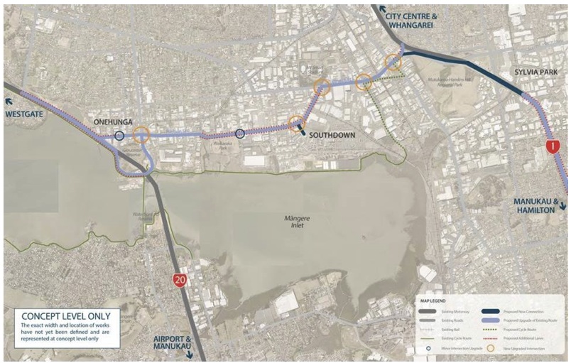
The option above not only cost much less than the previous East West Link proposal, its economic analysis suggested that using Neilson Street actually delivered more benefit. Therefore, such an approach seems like a no brainer. Nevertheless, a couple of things worry me about this project and are worth keeping an eye on going forward:
- The $800 million allocated in ATAP seems like an awful lot, which may suggest that pockets of NZTA are still hopeful of delivering parts of the previous horror show.
- Because the whole project got resource consent in November last year, NZTA may be pushing for something that’s essentially “phase one” of the original East West Link rather than a proper “revised” project.
Normally we wouldn’t have a problem with a “staged approach” to building a project. It often makes sense to “do the most important bits now and the rest later”. This appears to be what’s happening to Mill Road, with the focus going first on fixing up intersections and dangerous sections of the road, with the full project to come later when it’s actually needed. The difference for East West Link, as pointed out by Infrastructure New Zealand (who played a critical and under-appreciated role in killing off the project, as an aside), is that even in 30 years time it’s clear the project will be vast overkill:
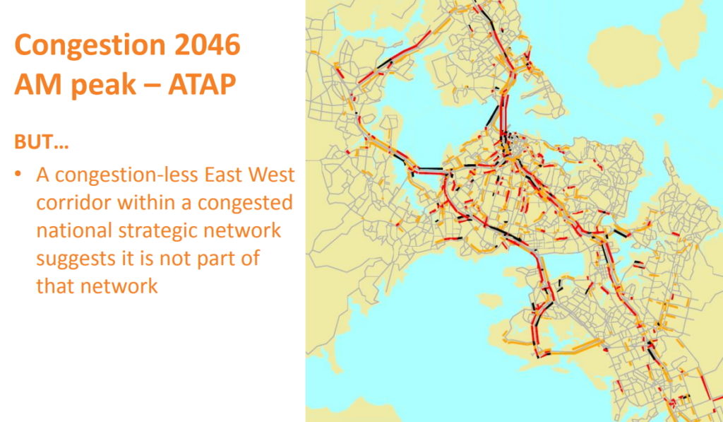
If much of the roading network is congested, but not East West Link at all, it suggests you should have spent much of your money elsewhere. Especially when you consider that this modelling is without the impact any road pricing scheme may have.
Getting back to the issue at hand though, we will be keeping a very close eye on what happens next with East West Link. In particular, we want to make sure that NZTA are not being sneaky and pushing forward with something that’s obviously just a stage of their original proposal – probably in the hope of a change of Government. All the previous work on East West Link clearly shows there are some better value for money options out there that make the most of Neilson Street, mean that we don’t need to destroy more of the Manukau Harbour shoreline, and don’t cut Onehunga off from the sea even more than it is now.

 Processing...
Hello Matt L. Recently you suggested in a piece that there was active pushback from NZTA towards a less road orientated policy. Now you mention that “… $800 million allocated in ATAP seems like an awful lot, which may suggest that pockets of NZTA are still hopeful of delivering parts of the previous horror show…”
The impression I am getting here is one of a department which is threatening to go full rogue on the government.
How much of that impression is true? Having a government agency actively resisting it’s elected masters is a scandal of the highest order, if true.
NZTA has long been about building new roads and maintaining existing ones. Most of the people who work for the agency have been institutionalised to consider building bigger roads an end in itself. ‘Corridor improvements’ to them means ‘increased road capacity.’ It’s kind of a case of “when all you have is a hammer, everything looks like a nail.”
Changing NZTA’s internal culture to be more about moving people than moving cars will require strong leadership from Twyford, Genter and co. It’ll also take some time to manifest in publicly available planning documents.
They have become a lot better at mitigating what they do with nice walkways and cycleways and urban design and stuff. But yes, they do still LOOOOVE their big roading projects. And why would they not, it’s massive budgets so they get to play with the big stuff, AND the old school folks get their extra car capacity… agree that it needs watching, or the community (and budget-destroying) projects will continue.
Just an aside – Not all engineers working for NZTA are like that. I know an engineer there who is a big PT fan and is a bit of a foamer when it comes to trains. I know that they’re not alone, but there is some “disagreement” internally as how best to do things.
There is cultural change required for sure, but it also requires more oversight from the govt.
Thanks for the post, Matt. What I’d like to know is which of the options for East-West Link satisfy the goals of the GPS: safety, access, environment and value-for-money. Would any of them deliver the step-change the government is wanting in safety? It’s a tricky area to make safe, with access required for (among other users) trucks and workers needing safe motorcycling and cycling access.
Last week’s damning report into Auckland’s road safety made many suggestions including:
“Implement Austroads Safe System Assessment Framework (ASSAF) developed by New Zealand and Australian practitioners over recent years at concept stage for major road projects within AT’s engineering function including project managers, designers and consultants.” and
“Request the central government to: adopt Vision Zero as the underpinning goal of Safer Journeys as an early priority”
If the East-West Link wasn’t designed with ASSAF and Vision Zero, then we are right to expect a fundamental revision that is centred on safety, not congestion-easing.
I’m not a transport engineer and I know nothing about Austroads, but from what I can gather Austroads considers a wide road with no trees or other impediments as safe. To me the safest roads are the narrow ones with lots of impediments (preferably trees) which will slow people down. Yes the odd idiot will speed down them at night and write themselves off, bad luck to them.
Thanks, Jimbo, I’d agree. It looks like I’m going to have to get out all the LoS recommendations and compare them, I’m getting such differing advice from people. Hmmm…
The traditional Austroads guidelines (largely developed on behalf of the various state roading agencies, in charge of the major highways) have this traffic-centric approach to them. But a lot of recent Austroads research has produced some very good thinking about what safe systems actually require, including some very interesting intersection designs (e.g. hybrid signalised ints’ns with speed management channelisation or platforms).
Is that something you could provide a link for, Glen? Any idea how the Austroads research into safe systems compares with AT’s RASF and draft TDM? Or has it informed it?
This is a pretty good study: https://www.onlinepublications.austroads.com.au/items/AP-R556-17
And this compendium also provides a good overview of various safe system treatments: https://www.onlinepublications.austroads.com.au/items/AP-R560-18
(Free to download if you log in)
Thanks.
If it isn’t some devious NZTA scheme then it would suggest some serious grade separation along the route. That would of course make the route faster and have safety benefits of pedestrians not mixing with trucks.
Does seem like a lot of money to upgrade an already large road road.
What’s concerning is the focus on truck movements when there are significant changes in land use throughout Onehunga. Given the sums involved it’s going to be around a decade before any project is complete and while these kinds of changes aren’t immediate I feel we risk spending money for a diminishing need.
All of that isn’t to mention that AC via Panuku is spending money on developments in the area which will be impacted by any scheme to appease the road builders and the truckers.
There is not going to be any drop in trucks around Neilson street in the next 20 years. Metroport, which is based there is Port of Tauranga’s rail served Auckland port, and it’s volume is always increasing. If ports of Auckland ever move, traffic through here will likely increase even more. There is a huge amount of industry around Onehunga, Penrose, Otahuhu and the airport, and you will always need trucks to deliver between the rail connections and end businesses.
There is an inland port at Wiri. NZ really needs a National Port Strategy.
That whole debacle proved once and for all that if a government wants something rubber-stamped then their is nobody more willing than a retired high court judge who hasn’t got his knighthood yet.
You have to wonder if AT are playing games with this road as well. For example the traffic lights around Gloucester Park Road and Selwyn Street seem to be deliberately timed to prevent getting a green light on both, even though they are really close together. In fact why is Gloucester Park Road not just closed off altogether? And when they filled in the rail bridge why didn’t they add an extra lane so people turning left off Neilson onto Onehunga Mall towards the southwestern motorway could make use of the green left turn arrow. This would have significantly increased the throughput at this major bottleneck for little cost. AT could have significantly improved this end of the road for pocket change years ago, the fact they haven’t implies that they want it to be bad so the govt will fork out for a motorway.
I very much doubt left turn off Neilson St would improve throughput at pm peak – most of this traffic is stuck at the on-ramp regulated lights.
Gloucester Park Road was closed off as part of the current design.
Traffic light control often equals flow control. After the am peak it’s generally more open, but around 8am is probably to prevent the traffic flowing too fast onto SH20.
I wonder how much difference to congestion just having lowered the old rail overbridge has made already? With the slow start of heavy trucks, it’s likely to have helped quite a bit.
I see in a Beehive statement, due to widening SH20 etc: “Motorists travelling between Alfred Street to Onehunga Mall, along Neilson Street are saving up to two and a half minutes during the morning peak travel time.
“There are also 800 more trucks using Neilson Street each day since last year, allowing truck drivers access to State Highway 20 on-ramp faster than they could before.”
It has reduced air pollution.
There is still a long (long long) queue of traffic at 6pm waiting to turn left to head northbound onto SH20.
This traffic still has to wait at the onramp due to congestion around the bridge/off+on ramps. So speeding up the thru-put at that intersection doesn’t fix congestion.
Taking cars off the road fixes congestion.
I can’t imagine a left turn lane from Neilson St would cost $100+ million.
Alternatively just mark the lane has left-only from Galway or further back.
They may do what you say when the next EWL design is finalised. Personally I think it would only be a temporary solution.
I’m not sure its all about rush hour. That Onehunga Mall intersection is busy many times of the day, even when the motorway isn’t busy.
They will never fix the rush hour issue no matter how much they spend!
Yes, but outside rush hour it is not really much different from the rest of Auckland. Certainly doesn’t require 100s of million to be spent.
There are larger cities that move more people. We just need to build our city more like they do – PT and higher density.
I can’t imagine a left turn lane from Neilson St would cost $100+ million.
I would say it is quite a bit different because it is mainly trucks and having them sit around unnecessarily at traffic lights for ages can’t be good economically.
I don’t want them to spend 100s of millions, I want them to spend maybe 10 million on the glaringly obvious fixes and then revise a few years later. The fact that AT hasn’t bothered to do that implies they are hoping to have it taken off their hands by NZTA.
1. I’d heard that NZTA was focusing on “stage 1” around Sylvia Park. Before doing stage 2 when the government changed. I’m not entirely convinced that this strategy has changed.
According to the NZTA board mintues from 1/March [1] they were reviewing the design, but had to take into account the new LT GPS.
[1] https://nzta.govt.nz/assets/About-us-2/docs/board-meeting-minutes-2018/minutes-20180301.pdf
2. “Upgrading” Neilson St will likely make Onehunga more of a traffic sewer. Fixing this is not an easy problem.
I stand by my primary opposition to the current design when applied to “upgrade” Neilson St design –
a. southbound onto SH20 is one lane up hill with regulated lights. Increases in arrival rate will make this worse.
b. northbound onto SH20 is one lane up hill with regulated lights. Increases in arrival rate will make this worse.
c. eastbound traffic is locked on SH20 behind this junction. Upgrading Neilson St will have not much impact.
3. Any good solution will likely involve tunnels or cut&cover. Expensive, but better than destroying a community and opportunity for the city at the port.
I would think some sort of combined truck and bus only lanes would go along way in helping this area. Get some people out of cars into buses as prioritise freight.
Matt your congestion map is quite misleading. It’s never designed to mitigate ordinary traffic congestion: it’s designed for the freight industry’s productivity.
I can see your point if the question is: What do we do with $800million?
But that’s never the question is it? It’s spent according to its NLTP category.
This job has been No 2 in the Auckland Plan ranking, and really high up there in previous RLTPs, because it is so supported by the freight industry. They really are going to spend the money here.
If you want to really tilt NZTA’s mind about this, knock on Ken Shirley’s door and form a common plan with the trucking lobby. With a common plan and a timing, it would be very hard for NZTA to disagree.
Note of course that it’s the trucking lobby, not just the NZTA H&O (whatever they’re called now), that are smarting from this change of government.
So your on-ground advocacy would be pretty welcome by the Minister, NZTA, and RTF.
So why did the scheme have six lanes for general traffic and no freight lanes if it’s just for freight industry productivity. Don’t believe the bullshit. I’m pretty sure they ain’t moving 12,000 trucks an hour through there.
There were certainly arguments internally to dedicate it to freight, but they also liked the SH1-SH20 link advantages to general traffic.
The current plan added four lanes, but did not remove the existing four lanes.
1. There was nothing to increase the handling capacity of the Onehunga junction. So arrival rate increase and not throughput increase = traffic sewer.
2. The current design had a trench (next to port) and overpass (over SH20). Trench and overpass is a three story height change = trucks would stay on Neilson St. So no benefit to Onehunga community.
The current design was about moving cars away from Neilson St, so the trucks could have it too themselves.
Separating general traffic onto expressway, from freight traffic onto Neilson, would have had the desired effect for freight productivity. Definitely right there.
No argument from me about the divisiveness of the trench; urban connectivity was the last thing on their minds, and totally wrecked Panuku’s plans.
Point still remains:
If GreaterAuckland wants to influence the result, get in there with the trucking lobby and form one. That’s the way the right plan has a chance inside NZTA.
Labour promised to get all interested parties together after the election and nut out the best plan.
Current method seems to be more of the past with NZTA working out what they want with no consultation.
From memory the previous government were looking to accelerate delivery of the project, presumably with a Crown funding injection to shift the investment case so that the NZTA Board could in good conscience release funds from the NLTF. The current government’s decision can relate to the withdrawal of the Crown top-up, but cannot, by law, go down to the level of prohibiting any Board decision to to invest in any specific project.
However, given that ATAP exists as the mechanism for defining Auckland’s major investment plans, that seems to be the place to look.
However x2, the NZTA is in theory well within its rights to press ahead with the original plan at some future point, so best to keep eyes on just in case.
Question: the foreshore option apparently had the benefit of containing heavy metal leaching etc into the harbour: was that B.S. or is it a remaining problem now that an inland option seems to be favoured?
I think there is very questionable benefit to the foreshore aspects. Certainly putting a road on the foreshore is not an environment benefit.
Forest and Bird have lodged an appeal. They would have more knowledge around this.
That’s ignoring the dodgy deal NZTA did with non-Auckland Maori.
Ta.
I need to correct my earlier statement: the acceleration was through streamlining the consenting, which let the NZTA programme the expenditure earlier, not the promise of a Crown injection (which was I think an early idea rendered unnecessary by later evolutions in the discussion, hence my confusion).
And it’s currently a local road, so the NZTA does not have complete freedom to act, of course.
NZTA is an independent agency. So the government can’t directly tell them what to do. They can instruct the board regarding priorities. And they can control the budget.
Given the NOR and consents are approved they could start building tomorrow if they had the budget allocation.
They still have national appointed people like Darrow in the Board- he got kicked off Manukau DHB recently. Surprised hes still on this one.
This maybe one reason why Moller left.
It’s interesting to read though the board minutes. For example:-
https://nzta.govt.nz/assets/About-us-2/docs/board-meeting-minutes-2017/minutes-20171110.pdf
I have finally gone to a good map! I see what you mean: it would be a State highway built on largely virgin land, so a pure NZTA project had it gone ahead.
There are a couple of large and many small drains from the catchment immediately adjacent. Much of that land is contaminated fill (rubbish) used to reclaim the harbour. There is significant leachate coming out of much of the shoreline. A large part of the E-W link plans was treatment ponds / wetlands which intercepted the normal flows and much of the storm events.
E-W to be considered for LRT instead?
Run it from Onehunga-Sylvia Park-Pakuranga?
Link up from the CBD-Airport LRT somewhere @ Onehunga
You could even do a cheaper option than the option B with just a single direction south facing ramp from Church St to SH1.
Which would be kind of weird of course. You can see a lot of the problem is the industrial area starting around SH1 in Penrose doesn’t have it’s own set of motorway ramps due to Mt Wellington & Ellerslie getting them instead. Would of been interesting if back when they built the motorway to have had the motorway interchange at Penrose at around Church St/SE H/way & a simple connection road across to Carbine Rd instead of the mess we have today (sorry no or half a Sylvia Park Shopping ctr as a result). Slight more carving up of Hamlin’s Hill & a bit of housing lost the only extra cost perhaps.
edit – I mean if a Penrose instead of Mt Wellington interchange but kept the Ellerslie one too.
LRT from Church St, through SE highway, Waipuna Bridge and to Pakuranga, linkup to AMETI?
There is some excellent high res aerial shots of the area from 2014 that I downloaded & can’t find the link to anymore from their website, but they are here if interested: https://www.dropbox.com/sh/7aiptkq4b71wu70/AAAylGg9PX9e8BSPoy_DbPfca?dl=0
Thanks Grant, they’re great.
No problem
The 2046 congestion prediction model is based on the absence of east west link.
If the east west link is present, some traffic that uses other roads will be shift to use the east west link. That prediction diagram will change significantly.
Well the real world information gathered by Google would disagree, according to Google the network is already more congested than that in many, many places not shown on this picture. I think the people responsible for this should resign for incompetence or corruption, because they are even ignorant or at worst, perpetuating a hack job!
Here is an idea I’ve been thinking about:
https://imgur.com/a/C1V4rM8
1. Cut and cover trench from around Galway to SH20.
2. Turn Onehunga Mall south of Neilson St into a shared space. Maybe with the LRT down here instead of the gully.
3. Close the off-ramp on the west side. North to west bound could get off and back again again at Queentown.
4. Turn Victoria and Neilson St into a controlled intersection with traffic lights.
5. South bound traffic from Neilson St will go up a ramp off Neilson St at still use the same on-ramp.
6. South bound SH20 to Onehunga traffic would exit at either Selwyn or Victoria St.
7. South bound SH20 to Neilson St would go into the trench.
Nicholas Lee that area could be designed a bit better, although I imagine that Continuous Flow Interchanges at the South-Eastern HWY/ Great South Rd and at Neilson St/Onehunga mall, and possibly at Church St/Ororoke Rd (all of which would require some minor land purchases to widen the interchanges) would go a long way towards improving traffic throughput along the whole corridor.
A modest part of Neilson Street is single lane, this can’t help either. Its a bit of a double edged sword, spend too much on ‘upgrades’ and your running into the same costs of just building a new corridor, would be interesting too see the modeling though. I think Continuous Flow interchanges could reduce congestion in several high-traffic intersections across Auckland, for instance at green lane also.
Problem is upgrading the road into Onehunga doesn’t fix the volume handle out of Onehunga.
I’d have to see how a CFI would work in context before I comment. But based on this youtube video [1] you could say that northbound onto SH20 at Onehunga is not dis-similar to this type of intersection.
[1] https://www.youtube.com/watch?v=7mjOPvsJyCs
Metroport dwarfs Wiri.