Death and taxes are said to be the only certainties of life but when it comes to cities, especially growing ones, perhaps it’s that they’re never finished. There’s always more that could be done to improve our transport networks. If by magic our 30-year list of transport projects were suddenly completed tomorrow, we’d come up with another 30-years’ worth of projects by the following day.
Following Auckland Transport’s disastrous draft Regional Land Transport Plan (RLTP) earlier this year, AT have gone back to the drawing board and also taken into account ATAP and the draft Government Policy Statement. This is now being consulted on.
The RLTP lists all projects that are proposed to be funded by Auckland Transport, the NZTA and Kiwirail. It was this section in the earlier draft where we found the budget didn’t match text of the document. This version contains over $10 billion in capital spending for Auckland Transport related projects. There is more again for the NZTA and Kiwirail.
However, what you don’t build is often just as important as what you do build, and the document also contains more than $6 billion in projects that are currently unfunded. Many of the items on the list are quite interesting, giving an insight to some of the things Auckland Transport have been thinking about. Here are some of ones that stood out to me. Also note, all of the costs are indicative only and the accuracy would likely vary based on how advanced work on the various projects has been.
Public Transport
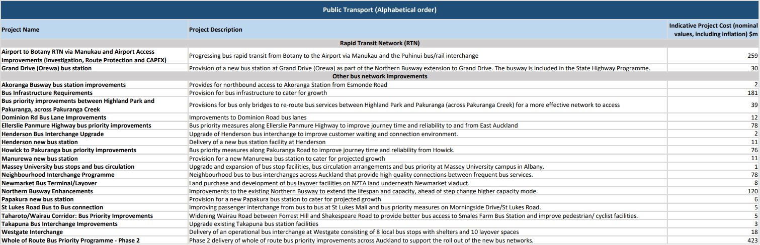
There is a huge list of unfunded PT projects totalling almost $2 billion across 40 projects. Many help address some of the issues that have niggled users for years, but being unfunded means they’ll continue to do so for many years to come.
Projects vary in size from very small at around 1 million, to quite large. The biggest comes in at $423 million for a second phase to the roll out of more bus priority – the funded programme includes $215 million for Phase 1. Other large projects include extending the planned Airport to Puhinui busway all the way to Botany, other bus infrastructure improvements, money for an as yet undefined ferry strategy and some improvements to the Northern Busway.
But it’s some of the smaller projects that are the most interesting. Some include
- $2m for northbound access to Akoranga busway station from Esmonde Rd – an issue I highlighted the other day.
- $39m for a bus only bridge over the Pakuranga Creek – perhaps this from La Trobe St to Hope Farm Ave like I suggested here.
- $31m for improved signalling on our trains
- $3m to open up access from the Newmarket Train station to Broadway and moving bus stops outside – this has been on the cards since the station opened again in 2010.
- $3m for an underpass at the borthern end of the Parnell Station.
The list of unfunded PT projects is below.
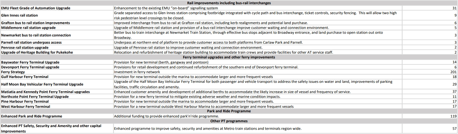
In addition to the dedicated PT section, there are a number PT related projects in some of the other categories. This includes
- $21m for a Browns Bay ferry terminal which is a local board priority
- $66m for investigation and route protection work for a number of RTN scale corridors – Described as Henderson to Albany/Constellation, Panmure to Ellerslie Mass Transit, New Lynn – Onehunga – Sylvia Park, Onewa/Glenfield Road and high priority projects planned for implementation beyond 2028.
- $66m to upgrade Quay Street to provide enhanced pedestrian environment and reliable bus infrastructure
- $23m for Victoria St linear park streetscapes, which they say is in support of bus improvements
While not strictly a PT project, there’s also another $424 million for rail level crossing safety improvements and grade separation. This is on top of $185 million for road crossings and $20 million for pedestrian crossings in the funded programme for it.
Roads
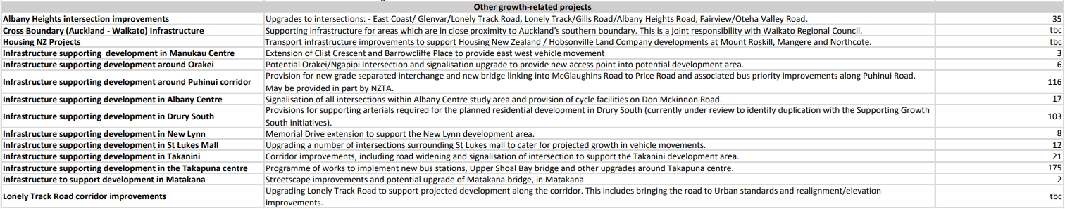
Outside of what’s be listed above, most of the remaining unfunded projects are road corridor projects and many of these are in greenfield areas to enable more housing in those areas – although they also contain some PT projects, such as new stations between Papakura and Pukekohe. I won’t show all projects on the list as it’s a long list and broken down by area but below are the ‘other’ projects which are more about supporting growth within the existing urban area.
There are a couple of interesting ones here.
- $175m for upgrades to Takapuna but lists as part of that is to implement new bus stations and an Upper Shoal Bay bridge – this is expected to be a new bridge from Barry’s Point Rd to either Northcroft St or Byron St and would likely be used by buses.
- $12m to upgrade intersections around the St Lukes Mall, how much is the mall’s owner paying towards this?
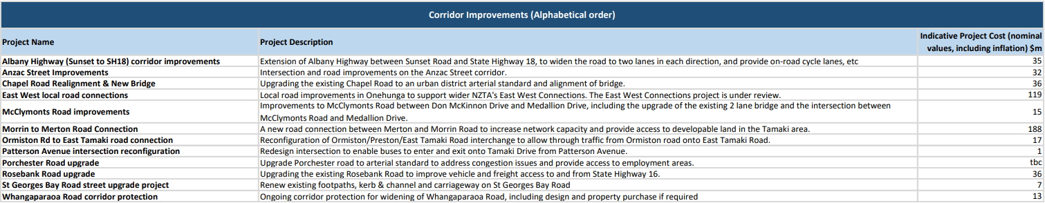
And these other corridor projects
- The Albany Highway section would include the intersection with Upper Harbour Dr which is in a desperate need of an upgrade (as someone who rides my bike through it)
- Why would we need to widen Whangaparaoa Rd if we’re building Penlink?

One final project in the unfunded list sits under local board projects and is $94m for the Te Whau Pathway.
I plan to cover the RLTP in more detail, including what is being funded, in a separate post later.

 Processing...
The bus connection improvements – and just basic access and shelter – at St Lukes is long overdue.
Agree. The city-bound buses drop you off just across Morningside Drive but it is very unsafe place to cross so you have to make a 5min+ detour down to the lights and back.
At the lights there is a slip lane with *no real waiting space for pedestrians* on the tiny island where you are supposed to wait by the traffic light button.
Once you get back up to the mall there are 2 huge car entrances but no marked or safe way in for pedestrians.
AT diverted nearly all the New North Rd buses on a slow detour via St Luke’s wasting a huge amount of most passengers’ time but then don’t even bother putting in some basic facilities there to make it useful.
Westfield clearly don’t care either. It’s my least favourite place to visit.
Yes, agree. So much infra there for the private car, and it’s a horrible experience for bus users, cyclists and pedestrians. That bus connections aren’t funded but Mill Rd and Penlink and new roads are is a sign of how far we still have to go in achieving a balanced RLTP.
As a good example, look at the Sandringham Rd / St Lukes Rd / Balmoral Rd intersection. A vast space allocated to the cars, a Clayton’s cyclelane, and see how close to the intersection the bus stops are not. Typical example of the PT network not being a network because you can’t easily swap between routes. Those bus stops need to be right beside the intersection, cycle and bus lanes are required the full length of both roads, and road space needs to be reallocated to achieve this. https://www.google.com/maps/@-36.8851069,174.7380759,188m/data=!3m1!1e3
Quick question… does anyone know if the Puhinui to Botany busway is going to require the removal of those nutty palm trees up the centre of Te Irirangi Drive? I remember when TID was first built, and wondering why you would fortify a valuable transport corridor strip with such bizarre obstacles…
When this road was built, Manukau City Council had a plan to have a rail line in the future – running in the center of the island. From Manukau via Botany to Panmure.
That plan would not solve the problem of getting onto the island. At the moment, to cross from Pakuranga Plaza to the bus stop for a bus heading toward Panmure, pedestrians must either walk about 150m to one of two light controlled crossings and 150m back, or take their chances crossing two lanes of high speed traffic to get to the island, then another two lanes to get to the other footpath. It’s highly dangerous but dozens of people must do it every day.
Why would they spend significant money building a light rail system and leave passenger access the same as it is now!?
Because at the moment the access part of the project would be deferred (Beresford Street) or declared out of scope to make the project fit into someones predefined idea of what was required (moar cars)
The jobs should be prioritised.
Those that give the best return/benefit for the people to be first.
Good managers will not spend large sums on stations like Parnel and Otahuhu for minimal returns
The unfunded bus upgrades at Manurewa and Papakura stations seem unnecessary, even taking into account of growth, given the facilities there are relatively new and adequate.
However, that Pakuranga Road bus priority and Ellerslie-Panmure bus priority remain unfunded is unacceptable given East Aucklanders have been screaming out for better PT for decades.
Have u used manurewa bus station? It was designed for 2 or 3 buses to park there but at times there can be 4-5. Not enough shelter for people south bound. Buses get delayed turn in from Weymouth road by 10 minutes because of traffic jams. It was not designed for the new network and it needs to be upgraded.
It may not be the most urgent problem to be solved but there are a lot of operations, comfort and safety issues that need to be addressed sometime in the future.
If the train station/bridges need to be redesigned for a third rail then it would be a good time to address parking and bus station issues ( plus potentially upgrade station for e buses).
Te Whau Pathway is unfunded? I had assumed that it was included in the cycleway / walkway funding. That is bad news indeed but not unexpected, it has always been amusing to read the grand proclamations of politicians about TWP and how work was starting immediately – and then see yet another park get a bit of concrete poured with no attempt to do the real work of joining them all up.
$31M for improved signalling on trains? What improvements? upgrade to ETCS level 2
and end all that crawling away from stations
Good question, but ETCS L2 would be a much bigger number than $31 mil. More likely a program of infil balises to optimize L1 function.
ok, but the wording ‘$31M for improved signalling on our trains’ made me think its an improvement actually on the emus. Therefore about $260k per emu driving cab. That would surely cover the cost of the GSM for ETCS L2 in each cab
Or if ‘on our trains’ just means the overall metro train system and includes lineside equipment such as infill balises then thats a very very expensive upgrade for a couple of dozen balises.
There must be a competent electronics manufacturer in NZ who make these for significantly less than $31M
I’m told the EMUs are already capable of their part of the L2 jigsaw. It’s the rest of the system that will cost. I’m also told that GSM may no longer be the communication medium of choice by the time we want L2.
If the “in-cab” reference really is literally about the things in the cab, it could relate to Automatic Train Operation in the CRL. Against that theory are rumours of that function being postponed, that the actual ETCS core equipment isn’t in the cab anyway, and that “in-cab signalling” is just the generic term for systems of that nature.
Regarding balises: Siemens is responsible for most of the signalling across the network, as well as ETCS and numerous other systems, so stealing and cloning their IP is unlikely to be a winning strategy. Besides, the cost of a balise is said to be only a tenth of the total cost of getting it installed, tested, programmed and a functional part of the network. Kiwirail and their signalling contractor could well be in for a windfall if this gets across the line. That said, the figure adds up to a lot of extra balises, so there has to be more to this.
I remember reading somewhere that Siemens didn’t want to continue with balise supply and advised looking for alternate sources. (sorry can’t locate reference right now)
Its always surprised me that for a few $ worth of balises why the emu creeping away from some stations has not been resolved by AT.
Perhaps if emus are already L2 equipped then full L2 may be possible by CRL open time although Automatic train control in CRL would be interesting to achieve that 30tph (or higher) in each direction.
Are you aware of any details of this being published and available?
The original supplier was Invensys, who were bought out by Siemens, who then supposedly refused to honour some form of warranty or liability for previous compatibility problems. Since then CAF have entered the ETCS market, so future EMUs may be equipped with a much better integrated set of hardware. It’s conceivable that this budget relates to a full retrofit of a superior kit.
I see in the old 2013 post linked to about missing links that Phil Twyford commented about the Whau bridge idea.
A lot of these projects are low hanging fruit – inexpensive yet useful.
I have a feeling the AT project teams are only interested in big projects that they can put in their CV and please the politicians, and nobody wants to do the small one.
That makes a lot of low hanging fruit untouched for ages.
AT need to manage their small projects list better and every project team should at lease take some of the smaller important projects.
Agree, so much small/medium sized things could be done all over the city.
+1
It is often the cumulative effect of several small projects that make a more meaningful impact than one big one.
+1
Perhaps such low-cost low-hanging fruit should be advocated for as a programme or package of works rather than on an individual basis?
– It’s easier for advocacy groups like GA to focus on one thing rather than many.
– Gives politicians one thing to focus on but with multiple ribbon-cutting opportunities.
– Potential for economies of scale when going through consenting processes, procurement etc.
– The sum of the benefits from interrelated projects may exceed the benefits from those projects individually (for example cycleways that connect to one another, making the whole network more useful).
Yes, good idea. Package it all up for the politicians etc.
I think our big new hub stations are nice but a bit too gold plated (Panmure, Otahuhu, Manukau) & so what other smaller items have missed out. Not only have they been gold plated but perhaps not all that ideally functional.
GI ped grade separating should be done ASAP before someone dies. Also the Eastern line would then be fully grade separated.
Westgate interchange also, just a crappy collection of shelters next to roundabouts.
It’s hard to believe that there is still a pedestrian level crossing at Glen Innes. How hard can it be to grade-separate a walkway FFS? Worst case, lifts or escalators can get people up and over in a small space. Again, priorities.
Maybe this could be funded from the ATAP? Worth contacting Councillors Desley SImpson and Josephine Bartley (GI train station is on the boundary of two ward areas) about to get it on their radars
Two level crossings actually.
Ranui is the same. I happened to visit there once. As I walked across the tracks, the bells sounded and the pedestrian gate immediately closed, trapping me on the track side of the gate. Perhaps there should be a time delay before the gate closes so pedestrians can get to safety.
https://at.govt.nz/projects-roadworks/train-stations-pedestrian-level-crossing/
Maybe it just applies to newer designed ones:
Using your safety swing gates:
Gates will activate automatically as trains are approaching.
Warning bells will sound, lights will flash, and the gate will close soon after.
If you have started to cross as the alarm and flashing lights begin, keep walking to the other side of the crossing. Enter the safety zone in front of the emergency exit gate.
Once you are in the safety zone, push the release button to open the gate and exit safely. If there is no button, simply push open the gate and exit.
Hmmmm, I don’t believe those options were available to me at the time.
There is an underpass already, but pretty dingy. I & I’m sure others actually find the northern ped level crossing very convenient & fast, but yes it’s abused and or with human error it is dangerous.
In the case of Glen Innes station right now, public visibility is an asset. Underpasses or overpasses only if they’re gated.
There’s still more chance of someone dying from an assault there than being hit by a train.
That did cross my mind, so overpass is better.
In the few years I’ve been going to GI I know of 1 death and 1 near death on the foot crossings, 2 serious medical emergencies, 1 organised brawl and 1 random skirmish with no serious consequences and literally dozens of near misses with foolish people taking chances on the foot crossings and jumping the fence from the car park. GI’s crossings are on the incoming side of the platform, so the trains are crossing at speed, not crawling away. Crazy to leave it to chance when people behave so poorly.
Papatoetoe pedestrian crossing will close soon and you should hear the whinging and moaning from people who are worried about “their Nana” having to walk up the ramps and across the foot bridge rather than scooting across a level crossing in front of an oncoming train. “Their Nana” of course, being their fat ass selves.
Numerous people have died over the years from being struck by a southbound train while walking across the level cross opposite the block of shops on Shirley Rd.
Good riddance if they decide fully fence it off, the ramps up and over the rail lines is only a few metres walking distance.
The ramps are at the other end of the platform. Looks to me like the entrance to the ramps are a good 300m from the entrance to the pedestrian level crossing, that’s a significant distance to walk especially as many people would have to walk down to the ramps then back up Shirley Rd.
I agree the crossing should be replaced by stairs but not just closed off. Making stations as accessible as possible is vital for their success.
The signs there say it will close soon, big gates are fitted there & the ticket gate building is being assembled right now. It would be nice if they added stairs in addition to the ramps on the northern side of the overpass. That would help shorten the route from the north for those able. The car parkers could probably use the exercise, tbh.
Totally agree kelvin, Grant, SM. Decades of road-centric planning has meant there are many, many low-hanging fruit projects just waiting to be done.
I believe one way to get things done quicker would be a local access fund from central government (who after all, have more funding available) a la the cycleways fund.
Either that, or a significant increase in funding to local boards to get local-level jobs done.
This is a great example of what could be done relatively cheaply:
http://ourauckland.aucklandcouncil.govt.nz/articles/news/2017/06/this-link-will-improve-cycling-in-orakei/
Enabling direct access through 92 Gowing Drive onto the shared path and the planned path linking into John Rymer Place means that (among other benefits) schoolkids can walk to Selwyn College or St Thomas’ School, avoiding walking or being driven along the circuitous route along St Johns Road, which (predictably as it is the only way across the railway line, i.e. a traffic bottleneck) is a nightmare in the mornings.
Providing a choice to avoid a traffic bottleneck – what’s not to like? Council only needs to find $4 million to make it happen, why has this not happened yet? AC needs to change their priorities to match their talk.
Could there be a mechanism for communities to be able to challenge local funded road projects and demand to see how the project stacks up against unfunded projects in the area, in the light of the stated new priorities of both government and AT? Particularly if the mechanism was clearly stated to enable a change of direction from car user to vulnerable user and sustainable mode projects, and thus could not be misappropriated by the people resisting change?
Are you aware of what’s been happening with Takapuna car park? Panuku wants to build apartments on it and is ignoring objections from business people who fear loss of trade, ordinary people who will lose their Sunday market venue and will be forced to park hundreds of metres away, and the Local Board which is unanimously opposed.
Isn’t the plan to move the market to Hurstmere Road after the streetscape upgrade by closing H Rd on Sunday mornings?
If you’re correct (and I don’t know), don’t the wishes of the community come first? There is near-unanimous objection to Panuku’s seizure of a community asset.
“will be forced to park hundreds of metres away”. Actually many people don’t mind. Note that you cannot park on that parking lot while the market is on.
Takapuna has an extraordinary amount of parking and yet the business area is still not particularly vibrant. Very likely the answer is not providing more parking, but instead to create an environment where people want to shop.
“ordinary people who will lose their Sunday market venue”
And is this really a reason to stop the building of hundreds of apartments that will revitalise Takapuna? There are numerous places that the market can go including Hurstmere Road and Como St. On the flip side there are not many large areas of free land that can accommodate large residential development.
As a resident of Takapuna given the choice between a car clogged town centre and a shared street pedestrian friendly shopping area I choose the latter. It is a real tragedy the Council don’t share the latter vision.
Of course another option is to build above the carpark so as to retain it. Sure it adds a little to the cost but not massively and you retain that space.
It amazes me that people talk about how vital the carpark is in the same breath as the market. Sure the market is great, it’s the busiest you’ll ever see Takapuna and I make a point of travelling far to get there… but when it is on you can’t park in the carpark, obviously!
“Forced to park hundreds of metres away” is already what happens the only time Takapuna ever gets busy.
I like the Panuku plan for the market, and I think it will be just as good or even better with the market stalls in the new town square, new laneways, and on hurstmere road and the green.
The market is safe, and the new parking building is going up. In that context, quite why anyone would want to keep an open lot concrete parking lot at the centrepiece of their town escapes me.
Yeah and if you are a business owner opposed to a housing project which will mean significantly more walk up customers for your business you must be bonkers!
Astonishing to see the Westgate interchange on that list. Ever since Westgate was a twinkle in Waitakere City’s eye, it was intended as a transport hub. The interim hub that opened mid 2017 is a collection of shelters on two roads out of sight of each other, no real time info (installed but not working) – a real hotch potch. So is that it till Light Rail or a Busway arrives then ?