There has been surprisingly little criticism of the Auckland Transport Alignment Project so far. One of the the only ones has been about the plan to build Penlink as a two lane road instead of four lanes. For example, the CEO of the National Road Carriers, David Atkin said:
Mr Aitken said the projects need to be future proofed now. “By the time Penlink is built the two lanes won’t be adequate, so they might as well build the four lanes straight away.”
While Stephen Selwood of Infrastructure NZ said:
“First, underinvestment in capacity to meet foreseeable demand must stop. A fourth main trunk rail line will be required in the future, as will four lanes on the Penlink corridor and the extension of the Mill Rd corridor. These investments open up land for housing, have positive economic benefits and should be front-footed, not reacted to when capacity is exhausted.
To assess if they’re right, we first need to answer two questions
- Does Penlink need to be four lanes, now or in the future
- Should we build all four lanes now
So let’s look at those
Does Penlink need to be four lanes, now or in the future
For most of it’s life, Penlink was considered as just a two lane road and was designated as such. Only in about 2015 did Auckland Transport decide to change that to four lanes as well as grade separating some of the local connections to the new road.
ATAP says this about Penlink and the decision for two lanes.
Transport modelling suggests that with a toll in place, Penlink has sufficient capacity as a two-lane road to meet foreseeable future demand, although it will be designed in such a way that it is future proofed for four lanes.
This doesn’t give us too much, luckily there is plenty of other information available in the public domain. A recent update to the Hibiscus Local Board confirms how many people are expected to use the new road, both if it’s tolled or untolled. The government have already confirmed that the road will be tolled and the modelling suggests 11,800 vehicles would use it in 2026 and 16,800 vehicles in 2046.
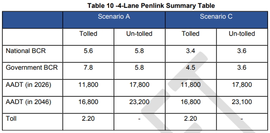
You’ll notice there are two scenario’s listed (A & C). This relates to whether southbound on SH1 is widened or not however both options suggest similar usage.
So, do we need four lanes? We can relatively easily test this by looking at other roads carrying similar volumes or more volumes. I started by looking at Auckland Transport’s road count numbers and focused on the 5-day averages as they represent working days as opposed to including weekends in the results.
This revealed dozens upon dozens of streets that carry similar or more vehicles to what is expected of Penlink but on only two lanes. Some examples include
- Abbots Way, Remuera (Kenneth Small Pl to Ngahue Dr) – 24,800 per day
- Station Rd, Papatoetoe (Ashlynne Ave to Gray Ave) – 23,400 per day
- Universal Dr, Henderson (Meadowcroft Way to Lincoln Garden Pl) – 23,500 per day
- White Swan Rd (between Hillsborough Rd and Lynfield Pl) – 23,500 per day
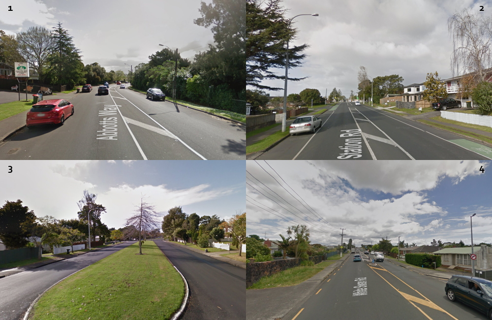
As you will have noticed, these are all two lane roads capable of handling more traffic than what is expected in 2046 if there was no toll. There are plenty of State Highways that we could include in this too, for example SH16 south of Coatesville Riverhead Highway carries over 33,100 vehicles per day and there are no plans anytime soon to increase the capacity of that road.
Pure carrying capacity isn’t the only issue that needs to be considered though. What happens when Penlink gets to SH1 also needs to be factored in. Currently SH1 in this area in this area is two lanes each way and ATAP doesn’t allow for funding increasing this. Adding two lanes of traffic to a two-lane motorway isn’t going to result in anything but congestion, negating most of the time savings Penlink is supposed to provide.
Next we’ve got housing and Selwoods comment about Penlink needing to be four lanes to open up housing is a little disingenuous. The housing it is supply it is intended to open up isn’t on the peninsula but in and around Silverdale and is meant to do that by taking Peninsula vehicles out of the Silverdale motorway interchange to free up that space for the cars of the new houses that will be built.
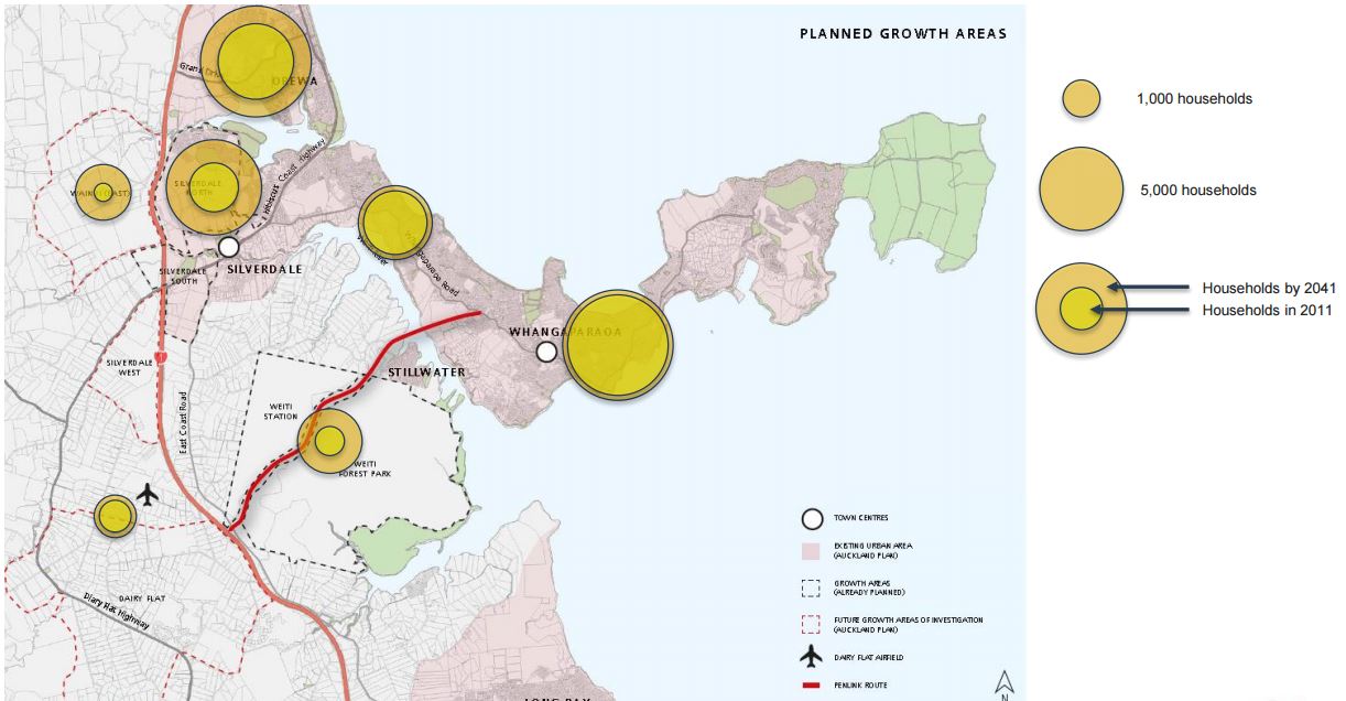
This was from before the Unitary Plan which now lists much of Dairy Flat (to the west of the motorway) as future urban land.
The Unitary Plan doesn’t allow for much more development on the Peninsula, perhaps if locals want the road to be four lanes it should come with significant upzoning to support it.
It’s also worth remembering that this will be a toll road. One of the features of a toll road is that you can change the toll to control how many people use it. Selwood himself is one of the biggest advocates for motorway tolling. If two lanes were insufficient, we could just change the toll to manage demand.
Finally, the strongest argument for building four lanes seems to be that it provides the opportunity for bus or transit lanes. The benefit of this seems dubious as most likely these extra lanes would only be needed near each end of the road, and that should be relatively easy to provide. As per above, demand could be managed to ensure the rest of the route flows freely.
Unless the modelling is completely wrong, there doesn’t seem to be to be a good justification to make Penlink four lanes, now or in the future.
Should we build all four lanes now
I think we’ve established that four lanes really aren’t needed for Penlink, but just for the sake of argument we did at some point in the future, should we build all four now. There are about 100 million good reasons not to. The overall transport package might be $28 billion over the next decade but there is a long list of projects that didn’t yet make the cut and many of those would likely provide greater value than the net benefit of four-laning Penlink. As the road is designed to be able to be expanded in the future, then will likely make it quite easy to do if it’s needed.
Even if four lanes are eventually needed, at least we’d by then we’d have a good understanding of just how accurate the modelling was.
If we have to have Penlink, then building it as a two lane road, at least initially, is the only sensible option

 Processing...
White Swan Rd between Hillsborough Rd and Lynfield Pl is an interesting example. This is the exact location of a bottleneck (the traffic lights controlling access to and from Lynfield College) that on school day mornings causes congestion throughout Blockhouse Bay and back to Green Bay and New Lynn – the location was presumably chosen for monitoring for exactly that reason. I’m surprised it manages such a large throughput, although it flows well outside peak hours, and the high figure is probably why nothing has done about the problem* over the last decade or more that it has been obvious. As I sit in the queues I will have to remind myself “it isn’t as bad as it seems”.
*There was one change made – a bus lane was put in on Donovan St about five years ago. At the time, there was only one route with buses every 20 minutes running along it during the morning peak and it was the subject of some derision but it now takes two (or more?) routes with at least one bus seemingly in sight at most times. The bus lane does not continue through the bottleneck area on White Swan Rd.
I notice that the bus lane stops to allow for flush medians (for right turning traffic). Classic example of prioritising the flow of the traffic over the flow of the buses.
“The Unitary Plan doesn’t allow for much more development on the Peninsula, perhaps if locals want the road to be four lanes it should come with significant upzoning to support it.”
A worthy principle to apply to all investment across the region – and I’d go further than new builds to include quality levels for ongoing maintenance. If people want to keep their single-storey neighbourhood, they can relinquish that fine-grade road seal.
Yes. How about a general statement to the whole city: We won’t build or widen any roads, as that induces traffic, and is irresponsible. We need to choose where we will put in major investment in public transport, but only medium intensity catchments will receive it. To get on the list for major public transport improvements, communities will need to agree to upzoning to medium density at least.
There is a parallel here with the story of the Auckland Harbour Bridge, specifically the idea that they screwed up building it with only four lanes and just had to come back and widen it ten years later.
You hear this a lot as a supposed example of the perils of not just building the big project up front and wasting money by not future proofing.
However, I went back and found the costs of the proposed six lane bridge, the cost of the four lane bridge they did build, and the cost of building the clip ons ten years later.
If you plug these figures into a NPV calculation it reveals the opposite to the common wisdom. Once you take the time value of money into account, building the four lane harbour bridge in 1959 and widening it to eight lanes in 1969 was actually cheaper than just building the six lane bridge in 1959.
The easiest way to think of this is that, over the ten years, the cost of borrowing the extra money to build a six lane bridge instead of a four lane one was actually more than it cost to build the clip ons.
To summarise, staging the delivery of the harbour bridge in two stages ten years apart meant that we got an eight lane bridge for cheaper than a six lane one.
So in fact, the harbour bridge is the perfect example of the best way to deliver transport capacity and exactly what we should do more of. Build smaller first stages up front followed by expansions as and when required.
Thanks Nick, I was wanting to do the same analysis but don’t need to now.
The parallel with the Harbour Bridge is excellent. If instead of a road bridge, they had put in a rail bridge, we’d be in much better shape now. All that growth on the north shore could have been PT-supported from the beginning. And the cbd would be much healthier.
Ditto for Penlink. There’s already a road. Another one will just induce traffic. What Penlink should be is PT-only.
The savings were not simply due to financial discounting of the timing of payments. Two major factors were the development of the steel box girder which became popular in the 60’s. The clip-ons were simply cheaper that building a truss. The second factor was the change in design load from a column on main battle tanks that might be needed if communists invaded to the legal axle load of some trucks in a mix of traffic.
Yes the box girder design was a lot cheaper to build and install than the truss design that the AHB had always assumed they would be adding to the 4 lanes core bridge design sometime around the late 1970s – if their original traffic projections had been correct.
What tanks ? Auckland isnt Prague. NZ had tiny numbers of tanks even in the 50s, mostly of the ‘lighter’ variety. Tank transporter trucks have large numbers of axles to distribute the load ( otherwise they couldnt pass over most ordinary bridges)
It was the cold war and after WWII these things were planned for as a contingency.
In that period they had a mix of Centurion main battle tanks and from the early 60’s Walker-Bulldog M41 light tanks. But the plan of the time was if NZ was invaded by communists then the ANZUS partners would join with their tanks. This is why the centre lanes are incredibly strong while the clip-ons wobble around more. Why a column of notional tanks couldn’t go through Riverhead is beyond me.
I wonder if the toll had remained on the Harbour Bridge whether Auckland might now be building a rail tunnel?
And whether the congestion on this route justifies the speedy introduction of a charge to create seed capital for that project. Just how much would $3 per day raise by the time the tunnel is to start? Just how much would this increase PT usage on this route?
The expense of introducing tolls would seem to be small given there is just one road to toll.
Of course, to those savings on borrowing, you have to then factor in the higher ongoing maintenance costs that the box girder clip-ons have needed as a result of cracking issues detected during and also since they first emerged in the 1980’s. So the true “total cost of ownership” to date of the bridge with the box girder design being added 10 years later when compared to the original idea of doing truss design bridge and adding similar type future extensions later had been followed.
I think it is likely to be wash at best.
All in so far its been a bit like we designed a 6 bedroom house originally, but only built 4 bedrooms to start to save money and had a lower mortgage, we figured the kids would manage. Then later on after a few more kids than planned, we borrowed some more and added 4 more bedrooms. But we only had borrowing capacity for money for those additional 2 bedrooms (to make it 8 instead of 6), ‘cos we took the new, but much cheaper “monolithic cladding” design for the extension – instead of the more proven and robust brick cladding proposal from the original house builder. Which would have only given us 2 more bedrooms [i.e. the original 6 in total] for the same sort of money as we spent to get 4 extra rooms.
But later on when the leaks started in the still-new extension we had to spent a bucket load of money [via more borrowing than planned] fixing up the leaky 4 rooms. The extension builder was out of business by then so we had to bear that cost ourselves. The extension is now ok, But have left a legacy of worry in our minds about how long the house will last…
..so we’re planning to build a newer underground house next door “just in case” …
But the truth is that clips on or extra lanes at all was only even possible only because they had designed the bridge piers/footings to have those extra lanes added at a later stage – which if they had not built those “larger than needed in 1959” bridge piers/footings, the idea of any additional lanes would not have been an option. And we would have needed an additional bridge instead…
🙂 And if instead, we’d built a one-room house such as the vast majority of our ancestors would have thought was luxury, we might not have had so many children.
If we’d made it a rail bridge, the traffic wouldn’t have grown. Just passenger numbers, but a third track doesn’t take anything like as much space.
Hah, you expect past present and future Aucklanders to show “moral restraint” and effectively live within their means and do so by living in a one room dwelling?
Yeah right, thats not gonna happen – not yet anyway. Why do people build and other still buy massive McMansions in the wops over apartments and attached dwellings closer in –
even if they can’t afford the McMansions?
And if we’d made it a rail bridge only design, we’d still be arguing the merits of building the damn thing and who was paying for it…
And of course, rail wouldn’t be so [politically] easy to toll either – ‘cos then the North Shore folks would be bitching and moaning about how expensive “their” train tickets are compared to the folks south and west of the bridge who don’t pay the bridge toll.
And don;’t forget as Miffy pointed out – the US Army [or even Old Blighty, aka Mother England] couldn’t drive columns of tanks or supply conveys over it during any real or imagined communist invasions. So it would never have got the go ahead.
He he. Moral restraint and Aucklanders in the same sentence! I can’t fault your reasoning, Greg. I was simply trying to extend your analogy to include elements for
1/ a rail version, and the smaller bridge size required (small house size?)
2/ induced traffic (numbers of children?)
A PT Harbour Bridge may not have been politically feasible then. But isn’t it a pity they’re not even modelling a PT Penlink?
They didn’t design the bridge piers for later expansion, it’s actually the fact that materials science wasn’t super advanced and they tended to make things five or ten times stronger than required just in case. The clip ones are relatively lightweight and cantilevered off the side.
To be fair, Jami-Lee Ross and Dan Bidois have been doing a lot of complaining, without offering anything by way of an alternative beyond getting rid of bus lanes on Onewa road and muttering about the folly “trollies” when they think the microphones are turned off. And the “Auckland Ratepayers’ Alliance” – which appears to be an astroturf front for the assorted grumpy old crazies of the C&R and Taxpayer Onion types – got caught out trying to skew a poll on the petrol tax (skewing the poll was “their democratic right” they thundered on the telly last night).
Goff swotted the latter off with ease, demonstrating why it is important to have a politician in charge of political changes.
By complaining I meant nothing from the usual suspects like Hosking. They’ve been no op-eds about it other than Simon Wilson’s positive peice.
They got distracted/side tracked over the Productivity Commissions “feebate” scheme for taxing vehicle imports of “the many” to subsidise the importation of electric cars for “the few”.
They’ll circle back…
My very favorite criticism from Jami Lee Ross was that Penlink users would be paying for using the road three times. This is just what National did to the health system. Ran it down to the point where many lost confidence and so decided to take medical insurance. And then when you come to use the policy often all of the costs are not covered and you pay a third time. So what was the point you were making Jami?
“If we have to have Penlink” – do we have to have it? Could $200m achieve more congestion relief by improving the Gulf Harbour ferry and its connecting buses? At present it’s roughly 2-hourly, which doesn’t compare with most other routes. Also it could serve more places, rather than only the CBD.
I suspect the catchment of Whangaparaoa Peninsula is not sufficient enough to justify a four lane highway, given that even getting the project off the ground hasn’t been made a priority by both the regional council and the government. I am yet to see any business case that shows strong support for either option.
I say go ahead and plan for two lanes, with the exception of the Weiti River bridge which could be futureproofed for 4 lanes. And toll it.
I think the main question is what happens when you plug a new four lane highway into an existing four lane highway thats already congested?
Or, what happens when you plug a two way highway into an already congested four lane highway. As Matt’s figures show, even a two way highway will carry enough traffic to be a problem.
Wont the cars be using Silverdale now and just have a shortcut ? Doesnt seem like total traffic will increase much ( Whangaparoa peninsula doesnt lead onto anywhere else)
Thats the main reason for 2 lanes, half of Whangaparoa will still go via Silverdale even if no tolls on Pen link
The disruption will come from merging traffic where its now free flowing but that can be managed by traffic signals like the rest of Auckland.
If NZTA would model it to show the induced traffic from the increased road capacity, we might have answers to your question.
“If NZTA would model it to show the induced traffic from the increased road capacity, we might have answers to your question.”
Heidi, why would NZTA do that? They are currently protecting the route for AWHC but have done absolutely no work to find how the inner Shore will handle the 65% induced traffic demand (their figures).
Waterview tunnels were supposed to be two lane until Steven Joyce decided 3 were needed, hence the no margin for error set up of no break down or emergency lanes whatsoever. It’s going to be real interesting when something serious goes wrong inside it.
So at least building the profile to accommodate future growth for Penlink is no bad thing.
Good analogy, Waspman. The Waterview Tunnel with 3 lanes each way resulted in 8% traffic growth in 8 weeks on Pt Chevalier Rd, between 5 Sep and 30 Oct last year. That has safety implications here. I guess 2 lanes would have resulted in less traffic.
Similarly for Penlink, how much induced traffic would 1 lane each way create? Two lanes? It will certainly mean people coming from other places will avoid SH1 and use the Dairy Flat Highway if they can, Hmmm, what other rat runs will get busier as people avoid SH1? East Coast Rd?
But hey, if we throw a little money at safety programmes, we can pretend this isn’t a problem.
We went through when there was a breakdown. The music on the radio stopped and a lady came on saying “This is the control room. A lane ahead is blocked. Reduce speed and proceed with caution”
This area is dominated by water. Why is this money not being poured into ferry services? Accessible ferry services. We have to get over this idea that cars are the only option for getting around. Let us get the northern train line running passenger services, build a link East from Kauakapakapa through Dairy Flat, Silverdale and on to Whangaparoa and Gulf Harbour. At least while we argue about the rain crossing the Waitemata from downtown. Then the Northern Commuters will have all options, train East to the ferry, train West to enter from the West, or bus straight South. Paradise one could say. Imagine the books one could read, the podcasts one could watch. The sheer education and relaxation prospects are limitless. Less cars = less accidents. More public transport = more time to read. Perhaps first responders would have to find something else to do but is that a bad thing?
Not a bad call but they would have to be fast which may mean expensive to run,
and easily accessible, say mid peninsula.
Yes, I have photos of my grandfather taking the ferry up to Orewa with his siblings when he was a boy in the 1910’s. Have we made progress?
I think there is scope to improve the ferry’s up there, but I don’t think they could be a comprehensive answer.
Auckland is unfortunately beleaguered by a combination of shallow sandy harbour edges and mudflats, and erratic cliffline coasts. There are precious few places where you can actually get a ferry close in to a part of the shore where you can also have people living nearby, or get land transport in close. You end up with wharves sticking out on little fingers of land, or you use a marina.
Combine that with a relatively long trip to downtown, and a relatively low demand for trips to downtown, and you don’t have the conditions for effective mass ferry use.
Maybe you could try and circumvent this with smaller, shallow draft ferrries hopping along half a dozen little wharves and linking to a range of destinations… but that would necessarily be slow and expensive to operate.
My guess is the solution is around busway or railway that can serve a string of neighbourhoods and pass through a range of destination locations.
Yes they are also quite prone to cancellations with bad weather especially up that far exposed. It’s when I really want them too die worse traffic in stormy weather generally.
Even with Penlink, the ferry will still be about 10km shorter and no traffic jams. At present the ferry takes 50min and off peak driving a bit over 40min, which is better than the comparative speeds for most of Auckland. PT has the advantage that you can do other things, as well as travel.
Do you really want to be on a ferry in the middle of a winter storm, it’s pretty exposed out there. Inner harbour ferries are great outer ferries are subject to a lot more adverse wealther.
I’d prefer we build the roads either side of the bridge with dedicated bus lanes in each direction and a normal traffic lane. [i.e. 2 lanes each way].
Thus ensuring PT is being included and can be used without hold ups from day one. And also mean whatever happens at the motorway on ramps or off ramps, the buses will never be impacted by SOV traffic in ‘their” lane.
The only question is then do we make the bridge itself 4 lanes wide or just two?
Two means we will have to force the buses into the regular traffic via merge either side of the bridge.
Four lanes means the buses and regular traffic carry on as they are in their own lanes.
The Penlink bridge in design is conceptually and visually similar to the Newmarket viaduct (which is a bridge, except it crosses over the Newmarket “valley” below, instead of water). which is actually two separate bridge structures physically joined together down the middle seam where the traffic separation barrier is.
Each bridge in Newmarket has 4 lanes of road space in each direction. Although only 3 lanes are used city bound for traffic flow control reasons north of Newmarket.
When they built it they replaced the entire structure in 2008-2012 for around $240m in 2012 dollars using gantry cranes. [as I recall it came under budget a little as well].
So we can build the bridge using a similar technique, with the pierheads/deck sections able to take 4 lanes of traffic plus central median barrier, which would mean the bridge is a little wider on the deck than each of the two Newmarket viaducts is now,
But all up I think they could build the bridge as 4 lanes for about half the cost of the Newmarket ones, especially as they don’t have to demolish any existing bridges as they go as they did with Newmarket either.
So, make it 4 lanes on the bridge at least. If the folks of the peninsula who mainly benefit disagree with the cost of the resulting 30+ year toll is requires, then so be it. They won’t get anything.
Personally I doubt the Government or AT will find a private partner willing to do the job assuming it is done as a Build, Own, Operate, Transfer PPP.
So may end up having to do the entire job itself. More costs . Although if its not a PPP the job will be simpler all round.
“Personally I doubt the Government or AT will find a private partner willing to do the job assuming it is done as a Build, Own, Operate, Transfer PPP.”
I think that assumption is incorrect. There are all sorts of PPP contract models the government could use in order to get the outcome they want. The outcome they want is to have the road built without the debt from it appearing on the government’s balance sheet, cause of self-imposed budget constraints. For example Transmission Gully and Puhoi to Warkworth are both Build and Operate PPPs, ownership will stay with NZTA.
As has been discussed on Greater Auckland before, just because a road is being tolled doesn’t mean the toll will cover the capital cost and operating costs over a long period. In fact toll revenue probably won’t even cover the operating costs. But to the general public it looks like the project is ‘user pays’ rather than the reality that is the government getting it on hire purchase.
Note this isn’t an argument against toll roads or PPPs. I’d just prefer open and honest discussion about what the merits of them are. I feel like PPPs are being used for political reasons rather than sound financial reasons.
A good point. The tolls are a nominal amount compared to the capital costs. Even Transmission gully with $800 + mill construction costs that doesnt seem to include land costs ( which in metro areas can be a large part of total cost)
If they wanted it totally off books as you believe is all that they want to do, they can pull any number of tricks just as National did with the RoNS.
Which really means a PPP is not needed – if off books is only what they want.
But the Gov’t specifically stated Penlink would be a PPP, therefore you have to expect based on previous comments by Labour when in opposition that means the financials for the tolling and other costings all need to stack up, otherwise they wouldn’t go ahead with doing a PPP.
They’d just go on or off books ala National and be done with it.
I think the intention here is that peninsula folks who invariably say they all support Penlink are simply being put on formal notice that “yes, it will be tolled, for a long time, and don’t think otherwise.”
Anyway lets see how these pensinsula folks actually vote with their cars/wallets when it opens and turns out the toll is far higher than the figurative “$1 each way” they have all mentally assumed it would be.
PPP is really used here as mostly a [convenient] crutch to bring in tolling on public roads, without the usual arguments of the merits of tolling.
The public has been conditioned to date that a PPP road – invariably means a toll.
The only PPP yet to be formally confirmed as such is Transmission gully. Given the cost overruns there to date, you assume the only reason they have had, to hold back on confirming that yes, tolling will be needed there, is that they simply that don’t know how big the toll has to be yet. So they are holding back on saying anything – in case of more cost overruns. As this avoids having to take the flack for both the toll, and eventually for it going higher. For now, anyway.
You can toll a road without an “official” PPP [like Tauranga’s bridge, the original AHB and the tolled road north of Puhoi], and when you look under the hood it is invariably a PPP structure – just that the first two P’s are both “public” – usually one part of the government paying the other part [usually central Gov’t] to get their “pet” projects done sooner.
In any case Labour has said in the past they are not against PPPs, but they simply have to stack up and not just in balancing your books.
So like the kibosh Labour put on the idea of a PPP for the Dunedin Hospital rebuild, which National wanted to do as a PPP. Labour has said, no, there is no real benefits of doing a PPP there. We will take the hit and fund the build of the new Hospital ourselves. So if they are happy to do that for a big expensive hospital in the bottom of the under populated South Island, why would they do it differently in the more populous Auckland region as well for a project likely to be one tenth of the cost?
Perhaps for vote catching reasons in Dunedin you say? Well most of the Dunedin Hospitals (Southern DHB) catchment is actually safe National electorate seats (e.g. Bill English, Jacqui Dean types), so I don’t really think so.
Has anyone seen any indications as to Shane Ellison’s intentions regarding PPP’s, given his experience in them?
If the toll isn’t covering much then why have it? In other countries the toll does cover everything, in Norway for example the tolls are pretty steep but once the project has been paid off the tolls are removed. In some cases like the Atlantic Highway the new road was far more popular than expected, the road was paid down quicker and the toll removed.
If the intersections are built with four lanes in mind from the beginning then expanding to four lanes in the future will be a lot easier and thus cheaper. Although, as you guys have already pointed out, it may never be necessary.
I suspect that grade separating intersections contributes a lot more to safety and traffic flow than four lanes. However in NZ we generally only get grade separation on roads with four or more lanes so it’s difficult to disentangle the effects.
Good post. The demands for four lanes on this link are nothing more than lobbying by vested interests.
Are they future proofing for future attempts to wind back ATAT 2 and widen the motorway as well? Quite apart from the capacity of Penlink, unless the motorway was widened, there would be nowhere for more traffic to go.
Why not reach a compromise? They could build two lanes on one side and four lanes on the other.
Two lanes looks to make sense… but it’s going to suck when someone crashes or breaks down and blocks one of those two lanes since there’s no short detour like there would be on those comparison roads mentioned in the article. (Just saying… people choosing to live on a peninsula are choosing stuff like this).
They already have that issue now, which is why they want the Penlink in the first place.
So its not new to them.
Of course, the residents of Whangaparoa could all be formally asked, will you pay toll $X for a one lane each way road or $Y (where $Y may be 2 times $X or may be lower say 1.5 $X) toll for a two lane each way road.
And see what they say. If they vote for the higher toll, give them the 2 lane each way road.
If not, one lane each way it is.
Dynamic/smart peak direction bus or T3 etc only lane could be the answer. If an accident blocking then dynamic for that section can be altered until cleared. See my comments below. I think I’m on to something for the ultimate inbetween 2 and 4 lane non regional Rd solution. If they could just do this along almost full length of Whangaparoa Rd instead I’d be happier though.
We have to consider, if we build it in two stages, it will likely cost 2x or more – consider all those fixed ‘reconsulting’ project costs, reprepare the site, rehire the machines and workers etc, plus construction inflation. Where as if we build now, it only cost 1.2-1.5x more.
Having four lanes means we can have two lanes tolled that is also used as bus lanes, and two lanes free to public.
With more capacity, the surrounding area can be rezoned easily.
Table 10 is a hoot, isn’t it? So NZTA believe widening of SH1 won’t affect the numbers using Penlink. I’m sure if I bothered to read the report, extra capacity there will just improve travel times, not induce traffic. This is the nub of our continuing bad transport planning.
Twyford, you need to tell NZTA that any models that don’t include the new trips from increased road capacity will be sent back to the drawing board. They are fantasies.
Really useful summary thanks!
Anyone know what is the expected level of the toll likely to be required for the 2 lane and the 4 lane options?
And was that used to set the traffic volumes used for the “tolled” options for the 2 and 4 lane options?
That report to the Local Board Matt linked to, shows most of the “benefits” quoted are mainly achieved through travel time savings over other benefits.
The Productivity Commissions just released draft report on low emissions economy specifically calls out roading [only] projects that rely heavily on travel time savings to justify them (as this one clearly does) as being very suspect and should NOT be used or relied upon for justifying future roading projects.
So given that advice, you’d have to expect this project may never get built as envisaged even if its in ATAP 2.0.
Suspect it will end up a dog like the Tauranga connecting toll road. Amazing that economic rationality seems to fall by the wayside when people are in the mentality of roads=free.
Yes people generally aren’t as logical as an economist, they really get put of direct cash payments for driving a road not aware of the $1,500 car repair & tyre wear etc etc coming up for driving the long winding way around for every trip.
So looks like before the Unitary Plan that Weiti area was going to have a big housing growth area?
It’s a pity these Mill Rd etc roads sometimes ideally need 1.5 lanes each way maths wise but can’t be done without a 2+1 road which has it’s downsides.
The answer is a smart peak lane road designed from the start if they really want it. Ie like whangaporoa Rd is trialing now!? Three lanes, two operating in peak direction. But as others have stated state highway one will be the issue anyway. Actually why not a peak direction smart bus lane? Assuming counter peak single lane is not clogged.
In any case this is going to induce traffic. The existing whangaparoa Rd smart peak lane could be a bus only one is a other idea. I guess adding raw bus lanes there now is quite hard due to width?
Whangaparaoa Rd does seem to have plenty of flush median space that could be reallocated to a bus lane – it would need to be designed with some of Harriet’s clever bus strategy ideas, to allow for different directions at different times of day.
Just like the trialing already. https://at.govt.nz/projects-roadworks/whangaparaoa-road-dynamic-lane-control-trial/ Probalby need indented bus stops ideally.
Except bus lanes.
Yes so a bus only lane variant of this would be interesting. Up the frequency of the buses at the same time…pretty hard to implement politically I guess.
Just saw your reply, so I’m changing mine. I wonder if this technology can be repurposed to allow it to be a bus lane without much effort. Perhaps once the costs of Penlink become understood, there might be some support for the idea?
The header photo closely resembles the three-laned Upper Harbour Bridge, now part of state highway 18 west-bound. So how about a three-laned bridge? Two up, one down; “widening” achieved by a second two-lane bridge to the east.
I don’t think that the bridge is the biggest concern here. Most of Penlink is south of the Weiti River crossing. Perhaps Penlink is more about enabling suburbanisation there? It’s as much of an east-west link as a north-south one, so it would link in well to the development (Albanisation) of Dairy Flat. Bringing half of the Hibiscus Coast’s population and it’s best beaches so much closer will help accelerate the build out of what was, in the late 1990’s, claimed to be a green belt.
As for overloading SH1, yes it will. But Penlink could extend further west toward Coatesville, Riverhead, Kumeu… If this was California, there would already be a motorway emerging along here. In the NZ context, this may be the first major step in that direction.
The bridge is itself the costliest part of the project.
Why build it for 3 lanes, when you can do 4 just as easily for not that more now.
Even if you leave it as an emergency stopping area for now, it will still be the cheapest way to add an extra lane – now or in the future.
putting 4 lanes on one bridge will be cheaper than 2 bridges, even if the bridges are staged.
And you won’t need more than 2 lanes each way either so 1 x 4 lane bridge is as big as you need for now.
And of course, the Penlink users will end up paying for the 4 lane option in their tolls, which if they balk at that idea, makes the irony of that, even more delicious.
The proposal involves building ~7km of four-lane quasi-motorway with grade separations/interchanges at East Coast Rd, Duck Creek Road (Stillwater), with provision for future grade-separated interchanges at intermediate intersections referred to as “Weiti Station” and “Weiti Forest Park”. Allowance will also be made for north-facing ramps with SH1.
I’m impressed! Expect an Upper-Upper Harbour Motorway to parallel SH18 in the near future. In the context of steep bridge, a five-lane bridge (3 up, 2down) might be justified.
So what are the public transport facilities to complement this new emerging motorway chord? First suggestion: make sure the northern busway goes THROUGH Dairy Flat town centre and get Penlink bus priorities to connect there as effectively as possible. Justifying the scale of this link will hasten the suburbanisation of the southern Weiti.
For context, 7 km is roughly the length of SH18 from Westgate to Tauhinu Rd in Greenhithe, just over the Upper Harbour Bridge.
“for example SH16 south of Coatesville Riverhead Highway carries over 33,100 vehicles per day and there are no plans anytime soon to increase the capacity of that road.”
You may wish to have a look at this http://www.nzta.govt.nz/projects/sh16-brigham-creek-and-waimauku/ – construction due to start later this year. “Adding extra lanes between Brigham Creek and Taupaki roundabout (four lanes, two in each direction) to help improve travel times in the short-term, ahead of a longer term project to reduce hold-ups on this road.”
I’d like to see the cost benefit ratio for building 2 lanes, and building 4.
I suspect there are other projects that score higher than the 2 lane bridge