Have you ever wondered why the land right next to Glen Innes station has not been developed? Land that would make a perfect transit orientated development opportunity with the Eastern Line meaning an under 15min train ride with great views of the basin to the City, as well as next to the partially completed and future Glen Innes to Tamaki Drive Shared Path.
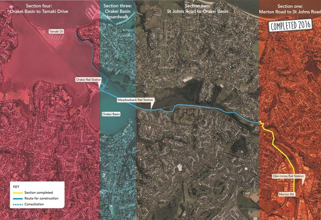
GI – Tamaki Shared Path
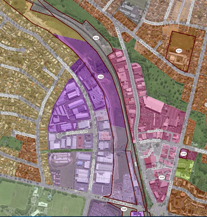
The land is also right next to some highly zoned areas in the Unitary Plan, Glen Innes Town Centre, as well as right next to the Tamaki Regeneration Area which already is seeing urban intensification and where Auckland Transport is working to upgrade the train station in the future. You can see part of the Eastern Highway designation in the map below – it is the area noted as “1620” within the dark red lines:
The answer is the spectre of the Eastern Motorway still haunts these lands carried over from the Unitary Plan. While the designation thankfully doesn’t allow the motorway to be built it does still protect the corridor. During the Auckland Transport Alignment Plan process, AECOM was tasked with looking at the potential of reviving the Eastern Motorway coming to the conclusion that it would provide seriously low value for money and be extremely expensive.

With the Eastern Motorway unlikely to ever happen due to the poor value for money, environmental reasons and local opposition, and with a housing crisis looming large we have to ask ourselves is protecting this corridor the wisest thing we can do? Much of the land is also already owned by either Auckland Council or the NZTA meaning that it should be easy for the Government to surrender the unnecessary designation, do a clever bit of rezoning to “Mixed Use” or something similar, and get on with building a fantastic transit-oriented development right next to Glen Innes Town Centre and train station.

 Processing...
It is the only remaining protected corridor out of the city centre. Once it’s gone, it’s gone. By all means build on it, but make sure you’ve protected enough space for projects we may need in the far future, too: four-tracking the NIMT? A light metro line to Botany? High-speed rail? They may never happen, but if they do the future will thank us for leaving them the opportunity.
The corridor along most of the parcel seems to have plenty of width for four-tracking except at the train station itself? But it’s a fair comment.
Stephen
I agree but that could be safeguarded with a fraction of this corridor, which was obviously set aside for a freeway with large earthworks. It looks to be a minimum of at least 60 to 80 metres wide.
If you want to make certain you can get to four tracks of heavy rail, allow 10 metres for the two tracks including clearances, plus another 3 metres for signalling and a maintenance track. Add another 3 metres for a cycleway. So worst case your corridor might shrink by 16 metres. All the rest (min 45+ metres wide up to 80 metres wide) could become residential or mixed use with no problem. That is a lot of homes.
And as others say, the designation has obviously blighted the old industrial area. With no motorway, a bikeway and housing next door, I expect it would redevelop pretty fast at current eastern suburbs housing prices. So your real potential is probably double what you can fit on the corridor.
This post is a piece of genius.
Since most of it is NZTA and Kiwirail designation, it would need a very smart and very active Minister of Transport to require NZTA and Kiwirail to develop a plan that housed as many people as possible with the maximum transport network access capacity.
Might take a bit of a kick to get NZTA to give up the future designation – because governments change but designations almost never – but it would be worth the effort.
Harriet, sincerely, just print this post out, mail it to Minister Twyford, and ask the headline question:
How many houses could you get on this land, without fresh Public Works Act acquisitions, and with the maximum accessibility?
I’ve always thought that the land next to GI station was ripe for a great development. Such a fast trip into the city with only 3 stops and no level crossings. Going the other way, you’re at Sylvia Park in 5 minutes.
You could fit 500 terraced houses there, no worries.
And a few apartment blocks please. Transit oriented development should be about both transport AND density.
Exactly. No point in wasting this land with only medium density. Needs to be high density for any new development located next to a train station (talking 7 levels +)
Short walk to Countdown or Pak N Save, positioned right on the cycleway too. Totally optimal for car-free living, when you think about it.
Glen Innes has a long way to go before I’d really be comfortable walking around after dark tbh.
Well by the looks of it, on the west there’s some low density commercial land use, and to the east is a town centre which I assume doesn’t have any population either.
Such a fast trip to the city, and the current population of the 5 minute walk shed is literally zero.
Developing that land is perhaps a good idea (depending on how confident we are that we won’t need that corridor anymore) but on the other hand, it seems odd to me to build up all the remaining open space, while the surrounding land remains so underdeveloped.
East of GI Town Centre is where the Tamaki Redevelopment Companies project is going on.
Thats the area where thousands of the former state houses (and tenants) are run out of town.
And the land they were on redeveloped into higher density living, with about 3 times the density of dwellings than it had before.
About 2/3rds of the homes built being sold to private owners, and the rest staying as social housing. So that GI had about the same number of social housing homes as it did before they started, and the old Housing Corp aimed to pocket the money made on the rest for other housing projects, elsewhere or give it as a fat dividend to the Government of the day.
Well that was the plan, when National was in power, or at least, the latest revision to it (of about, the seemingly one hundred or so revisions they’ve done since TRC was formed some time ago now).
Now Labour is in, its likely to change further and get even more intensively developed for even more social housing and KiwiBuild or whatever.
Which does bring the open space issue into play in that case, as if you take out most of the back yards the kids used to play in. You need some open space nearby instead.
So some of the corridor here needs to become Open Space parks and other recreational facilities. To compenstate for the planned loss in the eastern side.
The rest, well I understood NZTA pushed through the GI cycleway to St Johns Road to let them build on this land when they lift the designation.
No doubt NZTA were hoping to use the money raised from doing that for more motorway projects somewhere else.
It was mooted as the main route in and out of the City back in the 1940’s.
So its sat there and blighted the whole community ever since.
Hence why there is all that industrial stuff to the west.
This area has been crying out for something positive to be done with it for 70+ years.
Time it got re-purposed for people to use – not cars.
But first, as was suggested above, ensure you have all the likely Rapid Transit needs put in place or the rights of way reserved from that land before you break it up, as you’ll never get as cheaply a way to deliver PT over it once its built on.
My grand suggested plan for that, FWIW, is that this land becomes part of a [future[ Light Rail route to the GI terminus of a future Newmarket to GI Light Rail line, which uses Remuera road (which used to have dual tram lines down it until the mid 1950’s – terminating at the old Meadowbank shops on the corner of Meadowbank Road and Remuera road about 2.5km as the crow flies from GI. And carries along St Johns Road to the top of St Johns Hill then proceeds down the land where the Motorway designation is now, coming to its terminus/end beside the GI railway station. [Rather than using College Road/Merton Roads as I think the geometry wouldn’t work but it may, just needs investigation]. That would provide a easy link up and down the hill to GI from St Johns and to Newmarket from GI, St Johns, Meadowbank, Remuera. From there you can easily link using CRL to points west/north or south.
Liught rail may not trerminate in Newmarket and could go up to Symonds St/K’Rd as the old trams did, but thats decades from now.
Key thing is if we ever want to do something like this, we have one chance to reserve the Right of Way or kiss that opportunity good bye forever.
https://goo.gl/maps/q327CroJDLF2
Are we thinking about different suburbs here? Looks like there is shedloads of open space publically available to me, even if we were to develop the whole designation.
There is a lot of green there, because there is a lot of schools there (about 7 I count) some are private, some are state.
So take those out of the picture [as after all, if you intensify, you either need more classrooms in those schools or brand new schools]. Either way you can’t build on them.
Then Point England reserve is being carved up – some for Treaty settlements, some for housing, some for organised sport fields which take up a lot of space. So it will halve in size as I recall. A lot of that is basically paddocks and nothing else.
Also, many of the roads are being fairly well reconfigured to make better use of the space along the green areas some streeets border so a lot of those green areas will go.
And note many of those green areas have open drains or creeks running in them – hardly super safe places for kids to play unsupervised.
I must be imagining the hundreds of acres of reserves linking the town centre to Point England Reserve (part of which is still open space if you convert it to fields) and up to West Tamaki Road.
“And note many of those green areas have open drains or creeks running in them – hardly super safe places for kids to play unsupervised.”
If your child is too young to play alone near a creek, they are too young to walk alone to a park. Your argument is meaningless. No suburb has “open space” if you refuse to count playing fields, wide linear parks along streams, and school grounds.
Colin Maiden Park, War Memorial Park, these are just two of the acres and acres of open space in the GI area
Compared with many Auckland suburbs, GI has a very high proportion of open space per overall land area, as noted above. The real issue in GI is the quality of open space alluded to by Greg. Steep terrain, overgrown vegetation, narrow entrances and lack of lighting make these areas unsafe and unusable. What is needed is a holistic approach to improve passive surveillance, connectivity, and amenity (including flatter, more usable open space).
What about the large chunk of land across the water on the northern side of the Meadowbank station – that would be a better development opportunity, and could be connected by bridge to the Meadowbank station.
That land is owned by Ngati Whatua. It might well become a great piece of development at some stage, but the if and when lies with the Iwi, not with government as in case of the land discussed in this blog.
That land is way too slip prone to be built on without extensive foundation work.
Same goes for the land between Orakei [up the hill] and Kepa Road that runs from the roundabout at Orakei Road/Ngapipi/Kepa.
That whole road is on very slippery underlying mudsoils, which are prone to slippage.
Thats why that part of Kepa Road is so bumpy in places – the ground under the road keeps slumping – towards Hobson Bay/Purewa creek.
I guess with enough money spent you can build on it, but maybe it should be left as open space?
From memory, I think that land has some stability issues.
Maybe they could actually spend some money on the train station first?
Development / demand drives station improvements. And capacity itself is not increased by (most) station improvements, so I don’t think there’s any problems with pushing for more housing development here even if the station is not upgraded yet – its a win-win and will increase the likelihood of something being invested into the station.
Glen Innes has more users than Grafton in it’s current dilapidated state. I’d also hope general safety concerns would prompt upgrades faster than ‘let’s wait until a run station gets busier before spending more money on it even though we’re not upgrading it’, which is a concerning and self-fulfilling prophecy.
I’m not saying what you seem to imply. I’m saying that all other things staying the same, more development will increase the likelihood of more investment into the station. All the other parts of your response seem grievances which may well be true, but have little to do with the fact of whether or not this stretch of land should get more housing?
And I most certainly did not say the station should get busier before X happens, or before it should get the same treatment as (reconstructed as part of wider rail line works) new station Z.
I’m saying that station is already extremely utilised for the condition it is in and any updates/funding for said updates to it should already be considered well overdue, not contingent on even further intensification.
Sorry to go slightly off topic, but what’s happening with the next phases of the cycle path ?
We’re rapidly getting towards the middle of the year and according to the published schedule the last three phases should be in build now. I don’t see much sign of activity.
I heard that because of uncertainty about further cycle funding, a lot of the decisions around bike projects that haven’t started construction are currently awaiting high level funding decisions in AT and NZTA.
On the good side, with the GPS signalling a good chunk of further bike funding, hopefully these decisions can now be made – to get cracking.
Oh, and stage 3 currently IS under construction. But it’s only widening to an existing path, so not as exciting. Should be done in a couple months.
That’s disappointing, stage 2 is the heart of the cycle way, without this it has no purpose. The existing stage 3 boardwalk is perfectly usable, stage 4 is a nice to have.
Wouldn’t this all have been funded at the time they built stage 1 ?
The existing boardwalk at stage three is completely untenable for cycling. I agree that it is ridiculous that such a key piece of infrastructure was held up while we threw 10s of millions at a court case for the EW link.
The original funding case was done on very high level concepts back in 2014 or so. Maybe it turned out to be a lot more difficult? Also, the construction industry has since raised their prices between 20 and 30% because of the boom – so on a big project that can cause massive money shortfalls if you are working with fixed funding calculated 3-4 years ago…
I would prefer the land to be used for a ‘linear park’ – with landscaped gardens, water features, child play area, cycle lanes, walking track and open spaces.
The heavy industrial and warehouses on the west of should be redeveloped into mixed used mid/high density residential overlooking the new park. Ground floor should be cafes looking at the parks from west
The train station should adjoint the park seamlessly, with shopping mall inside, and outdoor dinning and overlooking the parks from east.
But that commercial land is not owned by government, and thus it is not available to be redeveloped. And building a park before building housing makes no sense in a housing crisis. People living in cars and slum tenancies need homes first, parks second – there’s enough land in the parcel so set aside some square bits for good local parks without needing to create a linear park – let the apartments overlook the rail line gully (with greenery) on one side, and the cycleway on the other side (with greenery) instead!
Damian, where are the true brownfields opportunities? All I keep being presented with are “greenfields-within-the-city” proposals. The long-term solution has to be to keep what green in the city we have and to use the already paved over land to develop into housing.
Short-term solutions to the housing crisis shouldn’t preclude a city with fine-grained green infrastructure.
What I meant is that a brownfields-area-held-by-multiple-owners is not a development opportunity for govt (i.e. KiwiBuild or similar). Maybe if a larger single private site is available for sale, govt could buy it, sure. But I would not expect something to work where you have to get numerous different parcels together, some of which will hold commercial or low-density residential occupiers at the moment who have no intention to sell up.
Those areas need to be developed privately, and govt needs to enable that via zoning and similar moves.
Also, I don’t think ANY govt housing project is ever a short-term solution. Things take years even in private industry.
And lastly, while I guess I disagree with you in the sense that I don’t think we need to automatically keep any green space that exists now in greenspace in perpetuity (I’d rather ensure that our city sprawls outward less, protecting THAT green), as I pointed out above, there is no need to turn it ALL into housing. One can easily set aside local parks. But gotta identify the land first, and this looks like a prime slot indeed. Those neighbouring commercial properties can then follow, also being turned into homes over a longer period.
I think we do need to protect the corridor incase we ever want to 4 track the eastern line (perhaps in 40 years time) or put some high speed rail access to britomart in there at some point in the distant future.
[Looks around sneakily, then removes a lane or two from State Highway 1 for another track through the middle of the Isthmus]
I know, I know. Expensive and problematic. You are right. But still, just because all our motorways in Auckland have 17 lanes now doesn’t mean it has to stay that way forever…
No, but the fact there is already a train line next to the Southern Motorway makes it a confusing and quesstionable exercise to even suggest.
How so? There is also an Eastern Rail Line already too, and yet we are discussing extra tracks.
We do not need to depend so much on cars for forever. We may well get to a point where a modern high-speed rail (or another standard rail line, even) along the current rail line / SH1 corridor would make more sense than an under-used multi-lane motorway that could stand a diet.
Of course it will only become under-used, at peak time, if driving costs rise strongly or driving becomes less attractive in comparison – chicken and egg. But my point was that taking space from an existing motorway for rail is blasphemy at the moment, but should not be and may not stay that way forever.
So can I finally dump the book of plans I have on top of my filing cabinet for the Eastern Motorway? I inherited them and have always felt bad about putting them in the bin.
Gosh no. Keep it safe to pull out for amusement’s sake from time to time.
Cemetery has used a significant portion of the adjacent corridor land.
Warning – what follows has only homeopathic levels of relevance.
The current Grafton station only exists because of schoolkids. St Peters College had an activist staff member (Brother Monagle) who agitated for the train to pause below the school so students wouldn’t have to walk all the way from Mt Eden or Newmarket. This pause eventually became Boston Rd station which was later replaced by Grafton station.
Once upon a time Selwyn College was a liberal non-zoned school and students travelled from all over Auckland on slow crosstown buses. I often thought a rail stop below the school would have been great for the students, a worthy cause that the iwi could support and also set a public transport precedent for the suburbs north of the gully. Unfortunately Selwyn had no equivalent activist (Sociology teacher Steve?) so it never happened.
Selwyn College now has a zone but it stretches along the Eastern line from Orakei to Panmure. So I still think the stop would be worthwhile for all the same reasons. The proposed housing area in this article would likely fall into that zone.
This sounds like another good idea Harriet.
@bjfoe They could soon cycle to the school if connected path is put in to the Eastern Shared Path from either Meadowbank or Orakei stations?
Grant, the Orakei Local Board is working towards a north-south connection across the shared path, with access onto Gowing Drive and John Rymer Place. This would provide critical local access and an alternative (to driving) route to the schools. However, as usual, funding is the problem.
Maybe you could contact the OLB and show your support?