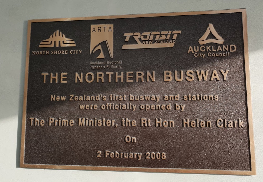
A recent newsletter from Auckland Transport highlighted that we missed an important anniversary. The Northern Busway turned 10 years old.

The busway was officially opened by then Prime Minister Helen Clark on 2 February 2008. It was built by Transit NZ (now NZTA) and at the time it cost about $210 million to build with another $84 million coming from the North Shore City Council for the stations. That now seems like pretty decent value compared to projects today, even when comparing similar projects, like it’s extension to Albany.
 The Busway has been so enormously successful that it’s hard now to imagine public transport in Auckland without it. It not only moves a lot of people (more on that shortly), it has helped save billions of dollars on needing an additional road based harbour crossing, pushing the need for one back by decades. It has also become an example for other parts of Auckland, showing that Aucklanders will happily use public transport, even buses, when high quality options are provided.
It wasn’t always viewed this way though. Like some of our other big PT projects such as Britomart and rail electrification, more than once was labelled a white elephant. One of the biggest opponents to it was the Herald’s John Roughan with opinion pieces like this – although he now uses it as an example of why we shouldn’t build projects like Light Rail. The cartoon below appeared the day after the busway opened.

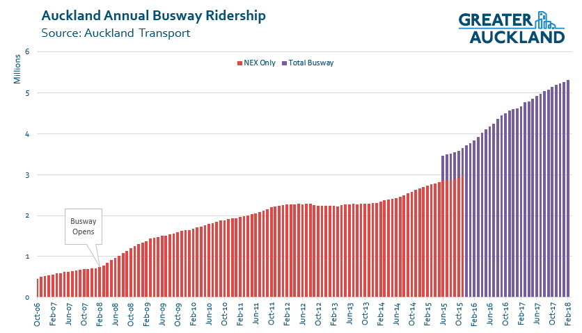
Now, over 5.3 million trips are taken along the busway every year and it continues to see double digit year on year growth. That’s in part because it is arguably Auckland’s only Rapid Transit route, given the poor off-peak frequencies on the rail network. At peak times, buses now travel along the busway every few minutes (in the peak direction) and even counter-peak services are running relatively frequently and are often quite full. As such, usage of the busway is actually starting to approach similar levels to the Southern and Eastern rail lines which each carry around 5.8 million trips. That’s not bad considering just 41% of the route from Albany to the city is actually on the busway proper.
Over the last decade, some of the key milestones have included:
- In March 2013 the Northern Express became the first in Auckland to get double deckers. Now, almost all NEX services are run using them and so do a number of 881 services.
- In 2012 the Albany park & ride was doubled to 1,100 spaces
- In October 2015 the NEX services were extended to Silverdale.
Initially, Auckland Transport and its predecessor ARTA only captured the usage on the Northern Express services but from mid-2015, that changed to reporting all trips on the busway.
Not all of the original plans for the busway were actually implemented. One big missing component was the initial plans for a busway station at Northcote Point at the old toll plaza between the bridge and Onewa Rd. That would have seen the full busway extended further south than Akoranga and allowed for a bus interchange with Onewa Rd buses. However, plans for the station were dropped after strong opposition from Northcote Point locals. I wonder if some of those locals reject that stance now?
Many also don’t realise is the busway was actually designed with the potential to carry high occupancy vehicles (like T2/3 lanes). You can see how they would have accessed the busway from how some of the stations have been designed and one of the more interesting is at the Constellation Busway station where there’s a short underpass leading from the carpark to the busway that has been chained off and never used. The inclusion of HOV features was to help get the original business case over the line. At the time many experts, the modelling, and business case evaluation processes didn’t believe enough people would use buses to justify it being bus only. But the busway has continued to exceed expectations and more recently Auckland Transport and the NZTA have said that introducing HOVs would have too many negative impacts on buses.
The busway has been a fantastic success so far and its future looks bright.
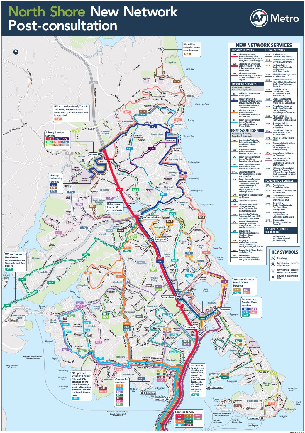
Later this year Auckland Transport’s New Network will roll out and see more services use the busway such as the NEX 2 & 3. Many other local buses interchange with busway stations to allow for easy transfers.
In two weeks time, the NZTA will start work on the Northern Corridor Improvements project which includes extending the busway from Constellation through to Albany. At the same time, Auckland Transport will be adding a new $70 million busway station at Rosedale Rd.

Longer term it’s likely that the continued growth in usage will see capacity constraints starting to create issues, particularly in the city. The strategic case for North Shore rapid transit found that by 2026, capacity constraints could start to have an impact in some locations and by 2036 most stations will have issues. That means likely in 10-15 years we’re going to need to upgrade the busway, likely to light rail. We believe this should ultimately be on a new bridge carrying just light rail and walking/cycling and the light rail should link into the route down Dominion Rd and to the airport.
Thanks to all of those who helped get the busway built.

 Processing...
Pretty amazing how low expectations were, both in key media commentators and also in the transport modelling that led to the stupid idea of needing T2/T3 to generate sufficient use.
We don’t still use the same transport model, right????
I think the problem with both the old transport models and John Roughan are the same: they are only capable of predicting future states from the current terms of reference.
The modelling for the busway at the time, like Roughan’s opinions, would have been based on inputs of how people *used to* travel, and calibrated to meet the observed patterns of how they actually did travel at the time.
But by looking backwards to look forwards, both the old modelling and Roughan ignore the potential for a fundamental shift in the way Aucklander get about their city. Build a fundamentally different piece of transport infrastructure, and people use it in fundamentally different ways. Clearly that happened with the busway, despite the rear view mirror predictions.
It is unsurprising that commercial media, (print, radio and television) are basically anti public transport and pro car. Commercial media is very heavily dependent on the income from advertising cars and vehicle services. There is no weekly advertising supplement for public transport services or prime time television advertisements for the latest railway carriage.
A move away from SOV transportation is very disruptive to a large part of our current, and influential businesses. That they allocate a lot of resources to push back is unsurprising.
This is why this blog is so important researching alternatives and placing this information in the public domain.
Related, I guess a lot of the time that people spend listening to the radio is in their cars. There are no guarantees that that practice would transfer over to digital devices on PT.
A lot of radio shows are now available as podcasts, plus bus drivers often play the radio. But you’re right, I definitely listen to the radio more in the car than anywhere else
Evening newspapers basically disappeared once people switched from PT to cars. People have a lot more time to read a newpaper on a train than they do when driving, so I think the papers could have done quite well out of PT.
That could be true but there are so many more entertainment options now that people’s choice may not be newspapers.
Lead image, people mover in the bus lane… Makes me wonder what they’re doing there.
It’s one of the airport shuttles, they have permission to be there.
How the hell can the new Rosedale Station cost $70 million?
Presumably it’s the same reason taking out a set of traffic lights at Kirkbride Road cost $140m.
Maybe it is just the difference between North Shore City Council and Auckland Transport. NSCC spent $84 million on four stations. AT want to spend $70 million on one station.
I understand most of the cost is to widen Rosedale Rd which requires rebuilding that entire section of motorway with a wider bridge over the top
Because four stations on relatively or completely flat, empty land next to motorways is totally a relevant comparison for a suspended station.
There is a reason that Constellation to Albany was left out of the original proposal!
Yes this isn’t too surprising. The cheap and easy bits are done first, cheaply and easily. The hard and expensive bits deferred until later are hard, and expensive.
Thinking about this a bit more, I think this is the new normal. We’ve moved into the phase where all the easy stuff is done. Think about it, the easy bits of the busway, electrifying and doubling the existing rail network and a couple of branches, bus lanes and double deckers. The motorways and main roads and widenings… all that lot is pretty much done with no easy corridors left.
Now we are in the phase of tunneling motorways and rail (Waterview, CRL), or demolishing homes and building flyovers for road widening and bus lanes (AMETI), or threading busways and LRT alongside existing corridors, while new motorways get cancelled or deferred indefinitely due to huge costs and disruption (East West, Harbour Crossing).
I think now Auckland really has only one choice, very expensive rapid transit retrofits or insanely expensive and disruptive motorways retrofits. There are no cheap and easy projects left for anywhere or any thing.
Nick – completely agree. I’d add the Kapiti Expressway to this, it was briefly the most expensive road ever built in the country as despite being flat crossed land that is quite challenging to build on.
The most expensive road ever built in NZ until a few years ago was the Northern Gateway at around $350 million. We have recently opened three roads that have cost more than this and have at least five more on the books.
“There are no cheap and easy projects left for anywhere or any thing.”
Disagree, but only very slightly: There are *very few* cheap and easy projects left for anywhere or any thing.
The light rail line Botany to Airport is fairly cheap and easy. Ti Rakau Drive and SH20B have corridors designated for widening that are perfect for rapid transit. The only expensive/hard bits are a short stretch of Puhinui Road and the motorway crossing.
Light rail from Mt Roskill to the airport is fairly cheap and easy as well, all in designated, existing corridors.
Northern Corridor Improvements at SH18/SH1 are also fairly cheap and easy for the same reasons.
Anything else in brownfields areas starts getting really, really hard or expensive though.
Take a look at an aerial and you will see they are building a suspended station because they want to not because they have to. Just north there is a yard used to store empty rubbish skips. Just to the south there is a large warehouse used to store cars for sale. Either of these sites is what NSCC would have opted for as they were spending ratepayers money and were answerable to ratepayers. AT isn’t answerable to ratepayers so they are opting for a station on a bridge which means they will pay through the nose.
Take another look at their plan. It includes two elevators and a pedestrian bridge at the height of four storeys above Rosedale Road. WTF? You can walk under the whole thing as it is built on a bridge!
This is the solution you get when the people designing it don’t give a crap about costs.
Umm Miffy they are building the station on that site with warehouse used to store cars. Acquiring that site is one of the major costs.
Last time I looked land is still cheaper than building a bridge structure in lieu of land. Where do you think NSCC got the Constellation Drive station from? Or the Smales Farm Station? They bought land.
Did you miss my comment earlier about the cost. It isn’t because the station is elevated, the busway and cycleway are being elevated over the road regardless so an extra few metres for platforms isn’t going to cost $70m. A huge portion of the cost is to widen Rosedale Rd due to it needing to completely rebuild that section of motorway
Yes Matt, they have to widen Rosedale Road to accomodate bus stops which are only necessary there because that is where they are putting the bus station. The cause is their decision to put a bus station right above, the effect is the need to build a whole new bridge. If they didn’t have to build a whole new bridge then the project would be cheaper, but they have made a decision to spend public money as if it is water.
NSCC looked at similar options. They considered a bus station at the Northcote Rd interchange but they went with the Smales Farm option because they had a budget and cared about what things cost.
I’m not saying light rail is cheap either, but by comparison both the Gold Coast and Canberra LRT schemes would have built two kilometres of track for $140m, including power and signalling.
Funny reading that old article linked to with ideas of special buses to take bikes over the bridge from an Onewa station by cycling through the ped underpass. Just happened to visit that area on bike last week so know the area a bit better now. The Onewa station could of been a bus only connecting one if residents were concerned about parking in nearby streets etc.
Even though plenty of people in Northcote Point probably would like access, if that isn’t possible an interchange only station is justified I think. It could be done cheaply using the existing tunnel. This would help with West to North connections as well as allowing better utilisation of buses going to different destinations on the city side. E.g. Ponsonby road buses from the north shore could be more frequent where anyone from the shore can get any bus going to Ponsonby Road.
Was there any draft or concept plans for this station. I would of thought approach and ext ramps would of been above the existing lanes rather than under?
I’m not sure, would be interesting to see what was proposed. My reference to a tunnel was purely about pedestrian access from one side of mway to the other.
Yes that confused me for a bit.
Yes there is an old plan from the first version of the busway design, I can’t find it but I did have it around here somewhere. It’s based on a ramp from Stafford Road up to the Onewa interchange, where outbound buses can turn left to go to Onewa Road or right to the buseway. However it relies on the busway being two-way between Onewa and Akoranga, which it currently is not.
ahhh thanks, makes sense.
oh forgot, and buses going south would of merged to the harbour bridge lanes on the left or centre?
I believe there way an early version where they crossed over then back again, and a later one where they stopped inline next to the toll plaza. Presumably that would have used the old foot tunnel or a new footbridge to get across.
A busway station at Northcote Point where the toll plaza used to be would have been a waste of time as there isn’t any land for a sloping grade into a tunnel. It’s sea water directly alongside and ahead. Akoranga is the one where there’s enough land to slope into a tunnel.
In either location there will be some reclamation, from Northcote it will be shorter, and it could be a bridge.
The only reason why the current designs have the tunnel from Akoranga is because it of AWHC road requirements.
Akoranga may be lowered, removing the need for reclamation. Northcote Point would be much more difficult to lower, and would be more prone to seepage and flooding into the tunnel if it was.
The current Akoranga design is a roads fest with heaps of reclamation. Once you in couple the PT crossing from roading you can do a bridge which will be far cheaper from Northcote.
+1, if you accepted no shoulder on the motorway, then you could get LRT to the Onewa Road interchange with *no* reclamation. and then start your bridge from there. Or get to the toll plaza with a tiny bit of reclamation and a realignment of the southbound motorway into the old toll plaza and a bus interchange there.
Interesting that the Busway was planned and opened in the previous Labour governments 9 year span.
[And as I recall vigorously opposed by many North Shore councillors, whose names I can’t recall, who decried the wasteful spending of ratepayer money on the grandiose
bus shelterstransfer stations. Thankfully most have long since moved out of local and central politics. Although the limited thinking in that approach stayed behind with some of those who remained].The current government at the 10 year anniversary was the newly sworn in Labour one. With plans to utilise the lessons from the busway and other PT projects in their funding plans for Auckland transport projects.
We now see in hindsight that the intervening 10 years have almost been a desert in terms of real PT progress.
Yes we we’ve had electric trains [and electrification] and double tracking of the western line, but these were planned for and finances allocated during the last Labour government. Even if the National Government delayed the implementation. The groundwork was all done by the last Labour Government.
So what does National have to show PT-wise for its 9 years in between?
Well we have the PTOM under which the “old” bus route system was “fixed” – which the new network roll out has supposed to have been put in place by now, and yet we see the new Network which is the second act of the North Shore PT renaissance is “still coming” (real soon now we get told often!). Those folks in the North Shore wanting an easy Bus-to-Busway “last mile” option for the last decade are still waiting.
We also got a mountain of roading projects, not least the new kid on the block, the Waterview project, which is now losing it “congestion busting” lustre after only 9 months. And of course we got the North Western Motorway (SH16) “improvements” which have seemingly been ongoing for most of this decade, yet are not keeping ahead of the traffic growth. Of course, the NZTA rejected the idea of a dedicated North Western Busway to duplicate the success of the Northern one. So instead we have a series of bus only shoulder lanes there which peter out at each set off off/on-ramps forcing the bus to compete with the other motorway users.
A Rapid Transit Option? Not! And definitely not what was needed or wanted.
So despite the $ Billions spent on these and other big ticket [and inexplicably expensive”small ticket”] projects we’ve gone backwards.
So yes, its great the Northern Busway is 10 years old, so it like Britomart before it – whose 10 year anniversary has come and gone too. Are both well settled into the transport landscape and delivering what they promised.
But its a crying shame that the [as seen from now, mild] promises made by both Northern Busway and the Electricfication of the trains, [and soonish, no doubt, the CRL too – maybe in time for Britomarts 20th anniversary]. These promises were initially roundly scorned as pipe dreams by the planners and prognosticators in charge.
Yet both busway and new Britomart station, the revamped old Diesel hauled trains, and now the new electric trains that used it, all turned out to be way more successful for moving people around than even the wildest dreams of those promoting them imagined.
And as a result both the busway and the trains have become victims of their own success.
Forced to fit into a coat which is now way too small – because they’ve grown so much more than ever was planned. And the “bigger” coat for both is some way off, so meantime the current one will have to be kept tied up with some manky bits of string – the buttons don’t do the job anymore.
And also because they have all been so damn good, we have given the transport planners both local and central an escape route which otherwise would have not existed. Delaying the day when they have to face up to the realities of the roads first approach.
So sadly, for the most part the valuable lessons from these projects have taught nearly everyone. They have more the most part sat unused by those charged with managing the transport system as a whole.
Instead they’ve wilfully charged ahead with yet more roads in those last 10 years, as we did for the 40+ years before. And we’re showing the limitations and results of that approach now, as never before.
The bad news – no matter how many more Double Deckers they put on the old or new bus network the congestion won’t get better anytime soon, as we are basically carrying on the same way.
We need to build some more circuit breakers. Just like we did with the Northern Busway.
Plus Labour/Helen Clark pushed for the WRR to go under ground IIRC, rather than smash through the houses & natural areas.
Greg N , a very well constructed post. I am very interested to hear what your circuit breakers are.
The moves that the Government announced today are a wonderful start to providing more transport options for Aucklanders. The huge question is whether they will be significant enough to arrest increasing congestion? AT projections still show motor vehicle trips increasing by about 25% out to 2046.
Can AT be dragged to the party to do their piece to facilitate more environmental friendly and congestion easing solutions?
Yes, watched these videos the other night, showing what Sydney is up to with “circuit breakers” – wow big time changes and spend up going over there, whole new Metro line with 31 stations plus other upgrades on existing lines etc etc let alone their new LRT lines. (PS Even their videos are better, but of course they have more $$ over there).
Main overview here: https://youtu.be/Hf2Bb1202Fg
Other interesting couple of newer ones:
https://youtu.be/Y9LmM0RBr40
and if you like a bit of disco: https://youtu.be/5akEN8x4KBI
What a wasted opportunities for Onewa/Notecote bus interchange. If it was built, the Birkenhead bus can transfer at busway station. It would increase Birkenhead bus service at same cost.
It demonstrated how ignorance those ‘residence groups’ are.
It also demonstrated ‘democracy mediocrity’ when too much power is given the the local NIMBY, where a lot of ignorance residences are hijacked by a few self-interested local leaders.
The next stage of development for the Northern Busway needs to be an initial rail-only tunnel under the Waitemata Harbour and converting the Northern Busway into a heavy rail line from Albany, linking with the City Rail Link tunnel.
An electrified heavy rail line to the North Shore will move far more people using less land space with no carbon emissions, than a busway or motorway lanes. With a fast heavy rail line from the North Shore linking with the rest of the Auckland rail network (and potentially the airport if a heavy rail loop gets built between Onehunga and Puhinui), this would be very attractive and popular with likely being much faster than any road-based transport, particularly during peak periods and as Auckland’s congestion steadily worsens, and there would likely be reduced demand on the Northern Motorway and Auckland Harbour Bridge. This meaning expensive road tunnels under the harbour would likely not be needed and the second harbour crossing project with rail-only tunnels which would then only cost half as much and could potentially be started sooner.
Why a tunnel? It’s far more expensive.
Why heavy rail? It’s far more expensive.
Why linking into the CRL? It will already be full of through routed services.
Why not light rail on a new bridge, which can be laid on the existing busway with limited modification, and upgraded to driverless operation in the future.
A tunnel is less visually polluting and will be less controversial and is more likely to happen. A tunnel would also be more suitable for heavy rail with less steep grades than a large bridge over the harbour will require.
Heavy rail is more expensive because it is better than light rail in that it runs on dedicated high speed corridors which are free of road congestion and heavy rail trains can carry more people and travel much faster than light rail – and links with an already existing network across Auckland. Light rail is more suitable for congested central city arterial routes for creating additional capacity, rather than speed, such as Dominion Road, Queen Street, Symonds Street, Manukau Road, Great North Road.
Linking with the CRL will enable a new North Shore heavy rail service to become part of a new through route eg. Albany to Pukekohe via Parnell. With an airport heavy rail loop between Onehunga and Puhinui, a new ‘tear drop’ shape through loop service could be created with linking the Eastern Line with the Onehunga line via Grafton and the CRL tunnel, which would link much of central, east and south Auckland along one route, as opposed to just the people living along the route of a single light rail line between Queen Street and the airport via Dominion Road, which would also be slower than a heavy rail train service.
What makes you think a driverless tram operation is an ‘upgrade’? Why remove a Driver performing a useful and safety critical role? Needlessly making people unemployed is not a good thing when we need more (decent paying) jobs, not less – particularly when Auckland has some of the most expensive housing and cost of living in the world.
“Heavy rail is more expensive because it is better than light rail in that”:
“it runs on dedicated high speed corridors which are free of road congestion”
This is a corridor feature, not a mode feature, on the north shore light and heavy rail would run on the same corridor, so there is no difference. The only difference is in the CBD where light rail can run on existing light rail tracks for free and heavy rail would require a $2b tunnel.
“heavy rail trains can carry more people”
Our current heavy rail units carry more people than proposed LRT units. This doesn’t mean that your statement is true for any one *line*. If LRT is a surface line in the CBD we can run 30 trains an hour, 99m long, for 19,800 pax/hour. If we need even more capacity, then we can build a tunnel through the city centre (which is cheaper than the HR tunnel due to geometry) and run 132m long trains automated at 45 second headways like skytrain. A total capacity of over 70,000 pax per hour.
“travel much faster than light rail”
Our heavy rail stock runs at 110km/h, there are LRT systems in place that also run at 110km/h
“links with an already existing network across Auckland.”
Heavy rail would link with the existing network through an interchange at Aotea, it is not possible to through route services. It is possible to through route LRT to either the NW, or Airport LRT lines.
“a single light rail line between Queen Street and the airport via Dominion Road, which would also be slower than a heavy rail train service.”
Except that it wouldn’t be slower, experts conducted an objective analysis which found that LRT was time competitive with heavy rail for the CBD to airport trip.
“What makes you think a driverless tram operation is an ‘upgrade’? Why remove a Driver performing a useful and safety critical role? ”
Driverless operation allows closer headways, which results in reduced wait times and higher capacity. It also reduces operating costs by literally millions of dollars a year. Driverless operation is safer because it removes human error. If you want to keep people employed, retrain them as transit police.
While your logic is internally consistent and you presented your argument clearly, I think that you have made some factual errors in your analysis. If those errors were removed, I think that you would come to a different conclusion.
@ Sailor Boy. I agree with you. Also I think that the first harbour LRT crossing could be direct to Takapuna via a new Onewa station (bridge and or tunnel across harbour) rather than upgrading the busway as such. Then retrofit the busway as well to LRT most likely using the same bridge or tunnel. This has the added advantage of taking pressure of the busway in general especially while it gets upgraded which could take quite a long time.
+1, You would also add an Akoranga Station between Takapuna and Onewa.
I think that it would still be possible to run buses on the busway while building LRT by going to single lane operation, as happened when the utilities work happened for months on end.
Yes Akoranga of course too, be interesting how they will handle the bus stations while in the middle of upgrading to LRT if not using a complete new station next to them or something. Would imagine a new LRT station under the existing Akoranga & a new Onewa one would be “easier” and require less reclamation especially if tunneling the harbour & not surfacing until somewhere closer to Takapuna.
Was before my PT interest the whole building of the busway etc. Was the single lane operation controlled with lights like a normal road work site type setup or just running buses in one peak direction?
Sailor Boy: in response to your responses:
“This is a corridor feature, not a mode feature, on the north shore light and heavy rail would run on the same corridor, so there is no difference. The only difference is in the CBD where light rail can run on existing light rail tracks for free and heavy rail would require a $2b tunnel.”
“heavy rail trains can carry more people”
There is currently no light rail network in the central city (other than the Dockline Tram circuit which is not really a light rail network), this all has to be built as part of which ever light rail routes are built, which will come at a considerable cost, therefore will not be ‘free’ as you state. Assuming light rail does get built into the CBD, there will be much greater limitations on the amount of tram movements it can accommodate and the speed at which trams can move through busy congested central city streets in the CBD, compared to the speed at which heavy rail trains could move through the central city via the CRL tunnel and a tunnel under the harbour. Overall a heavy rail network can move more people for the entire length of not just this line, but the who point A to point B jounrey, more quickly than light rail.
“Heavy rail would link with the existing network through an interchange at Aotea, it is not possible to through route services. It is possible to through route LRT to either the NW, or Airport LRT lines”
Incorrect that it would not be possible to through route a heavy rail service. This could be done by having the North Shore heavy rail line linked to the Western Line via the CRL tunnel and Mt Eden, the Eastern Line and Onehunga Line linked together as a ‘tear drop’ loop running via the CRL tunnel and Grafton via a new loop line between Onehunga and Puhinui via the airport to Manukau, and the Southern Line running in an alternating loop via Parnell and Grafton through the CRL tunnel – all through services.
I agree light rail services could be through routed, but for the light rail system to work most effectively with the greatest number of movements based on the two current proposed routes to Westgate and along Dominion Road, the line from Westgate would need to come into the CBD via Great North Road, Ponsonby Road, College Hill, Victoria Street West, Halsey Street, Fanshaw Street, to connect with the line up Queen Street and out along Dominion Road, operating the two routes as one through route. Trying to have additional light rail vehicles operating on these lines in the congested CBD city streets is not going to be helpful or help increase the number of tram movements and people able to be moved – and certainly not as fast as what larger heavy rail trains would be able to do via a tunnel beneath the CBD and harbour.
“Except that it (light rail) wouldn’t be slower, experts conducted an objective analysis which found that LRT was time competitive with heavy rail for the CBD to airport trip.”
The ‘experts’ which came up with this finding did so with being hired and paid by an organisation which already had a predetermined outcome and sought to have ‘evidence’ to support their cause. It is well known that companies and organisations use consultants to produce reports which provide favourable reports which support the desired outcomes by the client who has commissioned them. Common sense and fact will tell you that a light rail tram travelling via Queen Street and Dominion Road which are two of the most congested roads in Auckland, will not be able to complete the CBD to airport journey in the same competitive time as heavy rail. Trams will likely only be able to travel at 50km/hr at best along these two roads which make up around half the length of the route, whereas heavy rail trains can travel at much higher speeds for the entire length of the journey. A new independently commissioned study and report on route mode options to the airport needs to be commissioned by the Government which also addresses all the factual flaws made by the ‘experts’ you mention such as their not including the full cost of establishing a currently non-existent light system eg tracks, rolling stock, depots when comparing the cost of a light rail option to a heavy rail option.
“Driverless operation allows closer headways, which results in reduced wait times and higher capacity. It also reduces operating costs by literally millions of dollars a year. Driverless operation is safer because it removes human error. If you want to keep people employed, retrain them as transit police.”
How are closer headways going to be possible with a light rail system running through congested busy central city streets which are shared with road vehicles, pedestrians and cyclists – and be safer than a human pair of eyes which can be much more alert and responsive to the rapidly changing situation in this environment. Heavy rail also runs with a proper signalling system and the current system is only limited with headways due to the (cheaper and inferior system) chosen by AT and KiwiRail (ETCS level 1 which works off trackside beleases rather than live updating with a GPS system like ETCS level 2 does). Heavy rail services could be much faster than they currently are with a better signalling system and is safer and more reliable with a trained, skilled professional Driver driving the train – which the majority of the public would want if asked to choose between a driverless system or one with a Driver. ‘Transit Police’ (Transport Officers) do not get paid as much as Train Drivers and Train Managers, so this is hardly an improvement for employment opportunities for Aucklanders. There would be fewer Transit Police overall compared to having a Driver and Train Manager employed on every train.
My logic makes sense as it is common sense, and I stand by my conclusions and viewpoints – and believe you would agree too if you were to acknowledge some of your ‘facts’ and statements are actually erroneous and/or not fully thought through, which is understandable with someone who doesn’t have industry inside knowledge.
On opening day the LRT line planned for Queen Street will have greater vehicle capacity than the CRL on opening day, with 24 vehicles per hour per direction versus 15 vehicles per hour per direction on the CRL.
It is important to note that they are building an LRT line with running way and signals dedicated to LRT operation, not a tram line waiting at traffic lights and sharing traffic.
Constructing the LRT line on Queen Street will be an order of magnitude cheaper than building a second CRL.
Your ideas on LRT routing are weird, TBH, and they won’t run along Great North Road or College hill or whatever. The Northwest would run along the northwestern, the Airport line along Dominion Road. They would both converge at Upper Queen Street then run north to Wynyard. A second stage could extend those two lines to the North Shore.
And sorry, if you are going to ignore the findings of years of planning, design and review by specialists in favour of your old man in an armchair thumbsuck reckons on “your logic is common sense”, you might as well stop there and go read up on the proposals. You clearly have no idea what is actually being planned.
Robin you need to get some facts straight.
Light rail need not be a tramway. All “light rail” really is; is a system that does not need to conform to mainline freight standards.
Close to half of the light rail systems in the world today would run in their own dedicated corridors (please read up on Stadtbahn’s) and there’s nothing stopping their units from having the same passenger capacity and operating speeds as heavy rail multiple units.
I don’t think there’s any need nor much demand for a direct service between Pukekohe and Albany sorry. Most Rail commuters in Auckland will be wanting to commute to the CBD ad for those wanting that Albany-Pukekohe journey; They should have no problem making an interchange in the CBD.
And yes driverless trains are defiantly an upgrade otherwise they would not be the current standard for new system and older systems would not be converting to them. Driverless operation allows massive reductions in running costs and are statistically safer. The (public) money saved from driverless operation would circulate into the economy and be used more efficiently, leading to more employment opportunities for people.
Is it possible to dedicate a bridge lane to the busway? a silly question because I don’t often go in that direction, but if possible should be good for transit times? 😎
You would think so. They used to do this South Bound but got rid of it for some reason. The worst congestion is usually Northbound before you get to the bridge – that they never bothered to put a bus lane through here when doing the VPT prohect mystifies me.
Problem is off-ramp southbound to Ponsonby & northbound on-ramp from Curran St?
Would be so good if they had that. The bus often gets stuck in traffic over the bridge.
IMHO what the busway also did was put an end to a lot of silly argument along the lines of “steel wheels good, rubber wheels bad”. It helped us all realise that the important thing is not one mode over another, but using the right mode in the right place. And in terms of sheer-cost efficiency, as well as effectiveness, the busway is very hard to beat.
It did something else, which has really stuck with me in terms of my own thinking. I would always have argued that a challenge with LRT and rail systems is that needing to transfer at stations from one mode to another (=bus to rail) was something which created a measure of market “impedance”, and I still think that, unless the frequencies across both modes are very high (five minutes or so). So, when the busway came along, I thought, “Great, the transfer penalty is no longer an issue”.
Instead … what I saw was overcrowded carparks at the busway stations, because getting to the busway by car is always going to be faster than taking a bus. The end-to-end journey time savings are quite clear; if one drives to the station, and can park, a busway bus is every three or four minutes. Getting a bus outside one’s house – well, one might have to wait for up to fifteen minutes. Or longer, if one is walking to their stop.
Your welcome – Teamwork makes the Dream Work!