I thought I might do a little series giving an update on the upgrades Wellington has submitted budget bids for, the more recent upgrades and how their network could be run more efficiently.
In this post, we will look at the current network and the more recent upgrades.
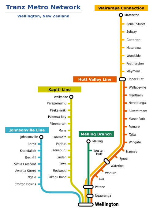
Wellington Rail Network
The network currently consists of five lines plus the Capital Connection
- Hutt Valley Line running from Upper Hutt – Wellington
- Kapiti Line running from Waikanae – Wellington
- Johnsonville Line running from Johnsonville – Wellington
- Melling Line running from Melling – Wellington
- Wairarapa Line running from Masterton – Wellington (Not Electrified north of Upper Hutt)
- Capital Connection a once daily peak return running from Palmerston North – Wellington (Not Electrified north of Waikanae)
For the most part, the network has the advantage of being a legacy one benefiting from investments made before the shift of thinking in the post-war period away from public transportation, especially rail. However, there are also downsides to this with many of Wellington’s issues being traced back to equipment that is past the end of its useful life.
The networks first electric service was in 1938 (!!!!) and this progressively extended over the decades, with the last extension to Waikanae in 2011. One downside of the age is that the traction system is 1500vDC compared to Auckland’s and the North Island Main Trucks 25kvAC. The main weakness of the former is that you need many more substation feeds, making it harder to extend electrification than the latter, however, it also doesn’t require as much clearance and can mean less adjustment to loading gauge on routes.
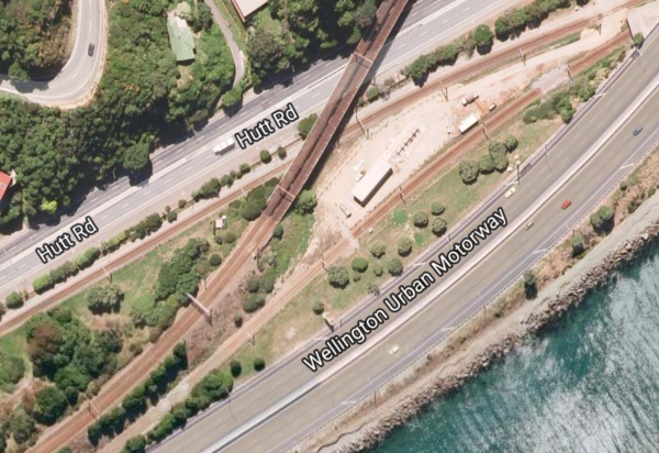
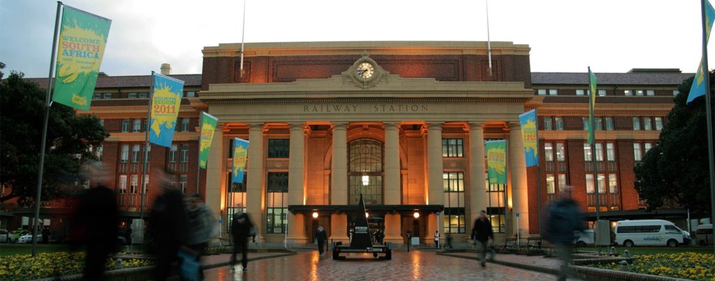
The network also has the advantage of a beautifully designed station, which has a 9 platform terminus with plenty of capacity. This is because the station can be served by multiple tracks, unlike Britomart which is only double track and would be very expensive to add further tracks. The network also has this amazing flying junction (pictured below) where the Hutt and Kapiti lines meet. This means there are no conflicting movements between the two busy main lines. Could we please have one of these for Westfield, please!
The big disadvantage is that Wellington station is at the northern end of the city centre, meaning many people have to transfer to buses to get further south. The other disadvantage the Wellington network has is the older signalling system.
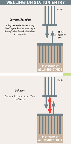
Unlike Auckland (which has the modern European Train Control System Level 1 compliant signalling), this means on the Wellington network there is no automatic train protection from signals passed at danger or overspeeding on sections, as well as lower feasible headways and apart from the third track in the yards approach to Wellington station (which operates in a peak tidal flow direction for the Johnsonville line) their is a lack of proper bi-directional signalling.
Recent Upgrades
Just as with Auckland where then then Regional Council (later AT/AC) pushed for upgrades under both of the last 2 governments, rge Greater Wellington Regional Council also successfully pushed for upgrades to the network including
- Extending the electrification from Paraparaumu to Waikanae as well as double tracking single track sections in 2011;
- Upgraded stations;
- Replacement of old rolling stock with Matangi EMU’s including traction renewal;
- Upgrading of the Johnsonville line for the new Matangi’s;
- A third track in the yards just before the approach to Wellington station where previously four tracks dropped to two limiting capacity;
- General KiwiRail catch up maintenance;
- In the last budget funding to upgrade 1274 old wooden traction poles to modern poles.
So that sums up the Wellington rail network and its recent upgrades, next post we will look at the upgrades that Wellington has submitted budget bids for.
Edited – Corrected Traction

 Processing...
Umm. Isn’t Wellington’s network 1500VDC?
Nominally 1500V, but can rise to 1600V and more and still be within spec.
But you are correct, it should be called ‘1500VDC’.
That’s interesting does that have any advantages?
DC is generally more efficient when you have close stations with more starting and stopping,
AC tends to be more better for longer distances between stops,
25KV AC is a post WW2 development and would not have been around when Wellington’s network was being developed so subsequent lines, continued with the original spec.
I suspect that Auckland’s choice of 25V AC would have been made in view of it eventually extending to the NIMT at Te Rapa.(+ the Auckland EMUs are seriously overspecced traction wise due to the requirement for future use in the CRL)
The Shanghai metro used 1500V DC overhead and that only began operating in 1993 , so its not cut and dry that DC is on its way out….
DC is still commonly used in LRT systems – Auckland’s would likely be 750V
Lower voltage DC induces less current into nearby metal things, with high voltage AC you need more clearance distance and greater insulation.
600 to 750v DC is preferred on LRT for that reason, stops it arcing to lamp posts, building awnings and inducing current into pipes and cables.
Always confuses me says one thing in one place and another elsewhere.
https://en.wikipedia.org/wiki/New_Zealand_FP_class_electric_multiple_unit
Harriet, the actual voltage present in the overhead wires will vary depending on how many other trains are in the same section, what they are doing, and how far from the nearest substation you are.
When a number of trains are drawing power at the same time they drag the line voltage down, such that there will be less power available for each train and what there is will have to be shared between them. A bit like a water pipe that serves several households, and if they all turn their taps on together the pressure (=voltage) drops and they all experience less flow.
The Matangis can operate at line voltages down to 1300V below which the control system shuts down and has to be reset. However extra substations and higher-capacity feeder cables were added before the Matangis arrived, to beef the system up and make this unlikely to happen.
Conversely when no trains are drawing power, and especially if one starts regeneratively braking (i.e. feeding braking energy back into the line), then line volts will rise. The Matangis can cope with an upper voltage limit of 1800V before things get upset.
My understanding is there is a dude at the control centre with a green Hornby/Tri-ang transformer with a red dial on it. If the red button on the front pops out he is allowed to reset it, but if the big red button on the back pops out he has to turn it off and get his dad to check everything is ok before they push that button back in.
Ha ha, I’ve still got my one of those up in the attic.
Dave, are the traction motors DC or AC in the new Matangis? Is there a limit on the number of trains there can be in one substations portion of the OLE? The DC current needed by each train must be significant if the power voltage droops down by 200 volts.
Are there any plans to convert to 25kv AC? or install ETCS?
MkeP – the Matangi traction motors are AC. There have been concerns which have led to restrictions on the number of 8-car sets that can run, and this is being further investigated to see if it is a significant issue or not.
There are only a few areas where voltages will drop that much and these are being considered for new substations. Such voltage droops do not occur under normal timetabled operation but tend to occur when trains are running late and get bunched together.
No plans to convert to 25KV. However ETCS is being looked at for the future.
As a matter of interest, back when Christchurch had a suburban (DC) electric tramway network, it was often observed that on days when popular events occurred (such as race days at Riccarton Park), the trams that left the venue after the event to return the patrons to their homes would slow to a crawl because of the number of trams in the section drawing power from the electrification system.
Correct Wellington has 1500VDC network not 1600VDC.
Interesting note that originally there were plans for the NIMT OLE to be 1600VDC before they decided on 25kVAC
The plan to electrify the NIMT at 1.5kV DC was under consideration before 25kV AC electrification was considered a “mature” technology. Obviously, electrifying the entire NIMT with a DC system would have been significantly more expensive, one of the reasons it didn’t go ahead at the time.
Have updated to reflect really interesting how it can increase as Dave has said.
There are a couple of lines not shown like the single branch to the Hutt railway workshops from Woburn and I believe the original intention was to go through the Wainui hill to Wainui o mata but the part built tunnel was used to store war goods and the tunnel never completed and is now used to have a main water pipe to supply the Wellington and Hutt valley reticulation. There use to be a bridge over the river near silverstream that connected to manor park but river changes took out the bridge and the line between Melling and manor park was disestablished.
The Gracefield Branch is not part of the current passenger network. In the past it has been used for race specials to Hutt Park and workshop staff trains, but AFAIK no regular public service.
The Wainui Tunnel was to have been a road tunnel. Not sure how serious any of the Wainuiomata railway/tramway proposals ever got.
It was always intended as a road tunnel, its got a gradient of 1 in 12 !!
http://www.gw.govt.nz/assets/council-publications/Wainuiomata%20Tunnel%20Brochure%20Final.pdf
The proposals for a Wainuiomata rail tunnel were very serious. Unfortunately, like the Wellington CBD rail extension and Auckland’s rapid rail proposals of the 1960s-70s, they never went ahead.
Here is a history of them:
https://en.wikipedia.org/wiki/Wainuiomata_railway_proposals
I have a copy of the report the Railways Department produced in the 1970s on the issue of heavy rail access to Wainuiomata (the last investigation I’m aware of into the idea). It isn’t flattering of such a project’s chances of being commercially viable. Wainuiomata’s population has been trending downwards from its peak last century; it is unlikely to have a sufficient pool of commuters anytime soon to sustain such a service, even with current plans for new residential development in the valley. Improved access for Wainuiomata would probably be more efficiently achieved by constructing the long-mooted second road access, likely a tunnel from the north end of the valley through to Naenae.
@J90
I believe the reason why a railway branch to Wainuiomata via Gracefield was found to be so commercially unviable was because Wainuiomata itself is considerably higher above sea level than Gracefield. While it is possible to extend a railway tunnel from Gracefield to Wainuiomata; it would require considerable works for a practical gradient including must likely ramping culverts in Gracefield on approach to the tunnel’s waste entrance.
In addition to that; I understand that experience with the never completed road tunnel established that the rock structure inside the hill is of a nature that is difficult to actually tunnel through.
I’m not certain if I agree with you that there wouldn’t be a population base in Wainuiomata to support suburban trains though. While its population has declined and isn’t currently that big; it would be safe to assume that a rail line would spur a boom in Wainuiomata’s population.
The Railways Department had originally formed an agreement with the Wainuiomata Development Company, the builder of the tunnel, to allow them to operate some sort of electric tramway through the tunnel if so desired, but this plan died along with the development company’s effort on the tunnel. Is this what you’re referring to? As for heavy rail, the last time I’m aware of the use of the tunnel being considered before GWRC purchased it and turned it into today’s utility tunnel, it was determined that it just wasn’t suitable to be turned into a rail tunnel, and due to the changed requirements of contemporary road traffic, would need modifications to that already constructed to be completed as a road tunnel as originally intended.
The previous rail bridge at Silverstream was replaced, in part, because it was determined that it and what is now the Silverstream Railway wasn’t suitable for continued use with the post-WW2 rail upgrade programme on the Wellington network (electrification and double-tracking).
I’m sure that if your put an electric train connection to Wainuiomata that the population would increase.
Quite possibly, but if simply improving access to the Wainuiomata Valley was the goal, it’d almost certainly be cheaper to build a Wainuiomata Naenae tunnel through which you could, if need be, run additional bus services connecting with Hutt Valley trains at Naenae station.
I’ve mused in other forums that providing passenger rail access into Wainuiomata (assuming non-infrastructure requirements such as funding and patronage could be met) would probably not be as simple as (per the 1970s proposal) just building a new branch line off the existing Gracefield Branch with a rail-compatible tunnel into central Wainuiomata. I’ve not gone through the exercise of working out what a service pattern for Hutt Valley passenger trains might look like if trains for Wainuiomata were included, but there could be capacity constraints in the existing network. This would be more of an issue around peak travel times, of course, when there are additional short-running services to Taita, and considering that (if the third triangle leg at Woburn were constructed) trains heading to/from Wainuiomata would have to either cross over the down main after Ava or join the down main at the “Woburn triangle”, limiting the movement of Hutt Valley trains heading south to Wellington (trains would have to be held at Woburn, Hutt Park, or Ava stations to allow for the triangle to clear). If this were to be the case, in addition to constructing the actual Wainuiomata Branch line, additional measures may be required to increase capacity, for example: a third main line between Kaiwharawhara and Petone (to be operated on a tidal basis), reinstating the Western Hutt line between Melling and Manor Park (to be used for express Upper Hutt, Wairarapa, or freight trains), or reinstating Petone’s third platform. Could end up being quite expensive.
Another thing J90:
I’m pretty certain that prior to the 1990’s there were regular railfreight movements out of Gracefield. Although I don’t know if there was ever a “Woburn Triangle” that has been lost in the years since or if the locomotives merely reversed at the old Woburn freight yards.
I also can’t imagine that there would be any capacity issues with a Wainuiomata branch. In former times; the Hutt valley line saw many multiples more freight traffic than it does today, more than it saw suburban EMU traffic, and it coped just fine. Even at peak times; the line is underused with only ~20 minute frequencies and has capacity for far more train movements.
Harriet, great to see you delving into Wellington’s issues from time to time. Unfortunately we do not have our own Transport Blog down here, or at least nothing with anything like the prominence of Greater Auckland. So your Wellington coverage is welcome.
One myth that really needs dispelling is that a lot of interchanging goes on between train and bus at Wellington Station, enabling buses to significantly extend the reach of rail. This doesn’t happen, and the proportion of passengers who transfer is very small. According to the 2012 Public Transport Spine Study the figure is only 15% (many of whom are students transferring to the Vic University bus). The PTSS correctly concluded that the big majority of rail passengers walk to their destinations, and that the limit of that walk for most people is 0.9-1.0Km (10-12 min). This gets you to around Frank Kitts Park or the south end of Lambton Quay. People with destinations much beyond this tend not to use rail at all, even if their journeys originate from rail-served areas. Journeys that require an interchange are generally much quicker and easier made by car and this is what happens.
Herein lies Wellington’s main public transport deficiency and the reason why it has a much bigger traffic problem than it need have. There is a whole lot of the CBD beyond a 10-12 min walk from rail, plus various major suburban centres, the hospital and airport beyond that. The regional rail system, excellent though it is for the areas it serves, is largely irrelevant in practice for these major un-served destinations.
Currently the only “solution” on the books is a motorway extension including two very expensive duplicate tunnels. No substantive public transport options have been officially developed, apart from a vague proposal for Bus Rapid Transit through the CBD (where ‘rapid’ will be limited to 30Km/h!), and an even vaguer assumption that some unspecified “rapid transit” can satisfactorily be shoe-horned into the proposed road schemes.
It is a pity we couldn’t have had Len Brown down here as mayor for a few terms, to inspire our mainly visionless local politicians to get behind the much-needed Wellington-City Rail Link!
Feel free to submit a guest post on the issue if you like.
Thanks. Will do if I can get a Round Tuit.
I’ve an octagonal one you could have. File the edges a bit and it’ll look fairly round, so long as you don’t look too close.
😉
I suspect the fact that GWRC insisting on charging extra for the inconvenience of train/bus transfer is a factor.
Certainly was in my case when I was a Wellington rail commuter – would only catch the bus when the weather was really bad otherwise walk to Willis St area. Tediously slow bus service doesn’t help either (relatively poor degree of bus priority & GW insisting on one main route with stupidly high frequency don’t help).
GWRC are pretty useless on ticketing a fares integration – always coming “soon”, just a few more years.
Ahhhh yes integrated ticketing. Found it strange to hear lack of transfers happening.
A good transfer point to light rail would also help I’m sure.
The broken spine is certainly the main issue. Transmission gully is supposed to result in a pile more cars entering the cbd too.
A lot of prime real real estate is tied up in large parknrides throughout the region where transit oriented development could assist in the housing crisis. subsisized ‘free’ parking or you have to pay to catch an infrequent bus from car dependant burbs.
Lower Hutt CBD faces similar issues to Manakau and Takapuna while the nearby Melling Line is poorly linked and also has limited hours plus poor frequency.
Add to that there are also a fair few golf courses occupying further prime relestate.
Many similar issues to ones the blog covers for Auckland.
P&R: need to charge for it, far too much spent on expansion – and more to coming seemingly. Could put parking revenue towards feeder buses.
Lower Hutt High Street faces the issue of having been malled to death. Last time I went there it was a run down dump – super sizing Queensgate has a lot to answer for …
Melling Line is planned to be cut back slightly with a new station as part of the Melling Bridge replacement and Hutt River floodway widening. Think it includes a new footbridge directly from new station. Not sure if there’s any plan about service frequency & span though).
The issue of ‘train to bus’ transfer is part of GWRC proposed integrated fare/payment for bus, train and ferry travel plan within the region.
With regards to your comment – ‘the only “solution” on the books is a motorway extension including two very expensive duplicate tunnels’, is the only option to relieve vehicle congestion in the city and around the Basin Reserve. Once the issue of the Basin Reserve is resolved, then more efficient public transport system can operate. There is a cheaper version that doesn’t require duplication of tunnels at the Terrace and Mt Victoria, is a trenched 3 way lane road similar to the Arras tunnel from the existing Terrace to Mt Victoria Tunnels but this means modifications to the Basin Reserve which the ‘Save the Basin’ group don’t want.
Re your comments – “It is a pity we couldn’t have had Len Brown down here as mayor for a few terms, to inspire our mainly visionless local politicians to get behind the much-needed Wellington-City Rail Link’. The cost will very expensive as the engineers would have to build a underground system consisting of both solid and reclaim soil and factor in land rises in future earthquakes. The rail yards, the station and north of Courtney Place is on reclaim land. The southern side of Courtney Place was part of the original shoreline. If the current cost is $3,4 billion for Auckland City Rail Link, what would be the cost of your ‘Wellington city Rail Link’ concept? It would more than the proposed $2.4 billion to complete the missing link between the Terrace and Mt Victoria tunnels.
Just out of interest what do the ‘modifications’ to the Basin Reserve involve?
The De Leuw Cather Report 1963 and 1966 Wellington reports shows a flyover from where the Arras Tunnel is now to Mt Victoria tunnel with on and off ramps for Adelaide Road and Cambridge and Kent Terraces and Adelaide Road would directly connect with both Cambridge and Kent Terraces. What land that was left over would be a park. This means the Basin Reserve as a cricket ground would have been history.
The Burrell Report 1980 report saves the cricket ground but show 3 or 4 lane fly over at the northern end of Basin Reserve. The Government of the day bought the land for the Burrell recommendation. With the Burrell recommendation, there was no direct connection with Adelaide Road and Cambridge and Kent Terraces, which meant the access to Adelaide Road and Cambridge and Kent Terraces is at present.
If there is direct access between Adelaide Road and Cambridge and Kent Terraces, would greatly improve traffic flows north to south and south to north but would mean the cricket ground would have to go.
The Burrell Report states “the Basin Reserve is the most critical arterial junction along the route. Turning traffic at the intersections in this area will become increasingly significant with future growth”.
They are some reasonably significant ‘modifications’ to the Basin! I think it is quite reasonable for the residents of Wellington to oppose loosing a park so that people from the Hutt, Porirua etc can get to the airport easier.
Jezza – There has been some fine tuning to the roads around the Basin Reserve but there is still congestion. Save the Basin Group manged to overturn to NZTA flyover plan reverting back to the problems that have plagued Wellington for the last 50 odd years. Unfortunately, there some Nimbys who don’t want to see their cricket ground disappearing nor having a flyovers blocking their views
There has been suggestions, to tunnel under the cricket ground using cut and cover and restore the cricket ground once work have been completed. There is another suggestion to tunnel under the cricket ground using cut and cover and once completed to connect Adelaide Road with Cambridge and Kent Terrace allow direct free flowing traffic north and south as oppose going around the cricket ground as at present and turn the remaining land into a park.
My suggestion for immediate relief at the Basin is to bi-directionalise the Inner-city bypass/Karo Drive/Arras Tunnel route – which could be done with a few kerb alterations and some new lane-markings – and focus all through-traffic on this route. This would allow the Waterfront Route, Vivian Street and Cambridge/Kent Terrace to be largely de-trafficked.
By converting the Basin “roundabout” from four arterial entry/exit points to only three, I believe there would be less conflict, less lane-switching, and traffic would flow more freely.
This would also bring major relief to the de-trafficked roads and enable them to function as city streets once more, not traffic-conduits.
Longer term, an extension to the regional rail system as I have described elsewhere in these comments will provide a realistic, ‘congestion-free’ regional PT alternative to the through-traffic conundrum, thereby alleviating the need for major new roading in the CBD area.
I think it is quite legitimate for residents of this part of Wellington to oppose having a park removed and flyover built in their neighbourhood, they after all are the people who use these streets most frequently.
If a fast connection between the Hutt Valley and the airport is so vital then it should be a tunnel. If this is too expensive to meet the requirements of the NLTF then I’m sure the users will be happy to pay for it with a toll.
@Dave B – I hear ya with
“as I am repeatedly reminded by my light-rail advocating friends in Wellington, “The lobby group for heavy rail extension consists of one person”!
Anyone care to join me and help make this happen?”
As a layperson observer of this conversation who’s a dedicated train commuter and Wellington citizen, I’m delighted it’s being had. And it’s dead intriguing.
But most of this exchange is just too much technical detail to show to others, given how little time I have to digest and peruse. The vast majority of folks who would theoretically join you in advocating heavy rail are probably in the same state.
Getting popular support for this will involve boiling it down to a Generation Zero / GA style network picture with some clean, simple “Pros and cons” bubbles for this vs light rail vs BRT.
Can Wellington’s progressive transport (including its heavy rail) advocates conquer our perpetual comms problem?
A lot more people use the buses from the interchange at the base of Rutherford House on the days when it’s raining 😉
It’s worth noting that Melbourne and Sydney have perfectly good networks using 1500V DC. Wellington would probably be 25kV AC if it were built now but it would also probably be standard gauge, these are relatively minor issues in the bigger picture.
“it would also probably be standard gauge”?
I dot mean to be rude here: But I think that building railways to standard gauge would be more than a mere “minor issue”! It would be a complete rebuild & realignment of the network. I doubt a railway built to standard gauge could even to to Johnsonville.
What would be the point in building Wellington’s rail network to standard gauge anyway? It uses the mainline and shares it with freight traffic on the Paraparaumu and Hutt Valley/Wairarapa lines.
I agree that in today’s age the Wellington Network would be built to the same 25kVAC as the Auckland network. But hey; what they’ve got does the job well enough if not as efficiently.
Harriet thanks so much for this!
I”ve taken the train all my life and learned heaps from this post. We have a few train-blogging folks around the region, but as Dave B observes, no single thing with the clout and reach of GA.
YET! Talk Wellington would love to repost your piece, may we?
Dave B – would you consider guest posting for http://www.TalkWellington.org.nz ? We need more folks with technical insight!
Isabella
Messaged your Twitter
Thanks Isabella. Request heard. I will get in touch.
Harriet, an excellent article, and a few comments:
a) your statement re bidirectional signalling that “the third track in the yards approach to Wellington station (which operates in a peak tidal flow direction for the Johnsonville line)” isn’t quite correct: the Johnsonville Line (bidirectionally signalled because it’s a single-line branch) runs parallel to the three NIMT/Wairarapa tracks with their bidirectional middle main.
b) “on the Wellington network there is no automatic train protection from signals passed at danger” isn’t quite right either, as at some signals protecting trailing junctions (eg Jville Line loops and the NIMT/Wairarapa junction) there are mechanical train stops that trip the brakes if a train passes the signal at danger (the London Underground had – maybe still has – a similar system). ETCS it ain’t, though!
c) also re signalling, Wellington A box, controlling the station area, is KiwiRail’s last surviving operational signal box.
I guess the need for triple tracking prior to the existing terminous suggests that any extension through the CBD also would need to be triple track, or would a signalling upgrade allow double? There might be space for triple track to follow SH1 but heading through the CBD, somewhere like Te Aro Park, it’d have to be cut & cover, triple might not fit under narrow streets and $$$.
Point of order, there are actually four lines into Wellington Station, not three. The Johnsonville Line is totally independant of the Up Main, Middle Main and Down Main. The Middle Main is bidirectional. While the Middle Main is generally tidal, it’s use it entirely at the discretion and skill of the Signallers.
I understand GW have a plan for using the J’ville line as part of a 4th main. This would presumably mean that it would double as bidirectional J’ville and Hutt northbound with a new track from near the motorway viaduct to Wellington Junction.
@ Anthony. You raise one of the various issues that scares people away from even considering extension of the existing rail system through the CBD. However the concern is unfounded. Two tracks would easily handle the full peak metro service if it didn’t stop dead at a single terminus.
The reason 3 tracks (ok, 4 if you include J’ville) into Wellington Station have proved necessary is because they feed into a terminus with a lengthy 20Km/h approach zone and a large amount of criss-crossing movement between inbound/outbound directions and between platforms and yard. At busy times it can be very difficult for inbound trains to get a clear run in. What the third track does is enable two trains to approach simultaneously side-by-side, instead of having to queue one behind another as previously. This benefit is largely only to inbound trains. Outbound trains face no such bottleneck so can much more easily proceed sequentially on one track. The centre track is bi-directional so it does tend to get used for some outbound pm services but the main benefit is inbound. And bear in mind that although the pm peak passenger flow will be mainly outbound, there are still a large number of returning empty trains that have to be pathed back into the station. So in practice during the pm peak, the centre track tends to be used in whichever direction is expedient at the time, particularly when things get out of kilter.
If the full metro service was extended, there are two possible options for handling the termination of potentially 30 trains per hour using only two tracks/platforms (Let us now dream and imagine the network is extended 8Km all the way to the airport!): –
One option is to have an intermediate turnback where half of the trains slip out of service onto a holding siding between the main lines, change-ends and wait there until time to re-join the service heading back, minimum 4 minutes later. Such a facility has operated for many years at Taita, for trains terminating there. In the case of airport rail, if it was not considered necessary to run 30 trains/hr all the way, 15/hr could terminate at say, Newtown, leaving a much more manageable 15/hr to terminate with a similar arrangement at the airport.
The other option if it is essential to have 30 trains/hr going all the way, is to have a “balloon loop” turnaround where trains do not actually terminate and change direction but simply run around a loop sequentially then head back on the other track. A conventional overtaking loop could of course be incorporated into this if needed. Ideally such a balloon loop would have a minimum radius of 200m so it would circumscribe a large area, but its location could be as-convenient and it could be buried / boxed-over /hidden without isolating the land enclosed.
In short, the possibilities to do much more with the rail we have are there (as also are options for light rail if that really is preferable which I personally doubt) if we could simply turn our planning and funding focus away from roads for long enough to give it some serious consideration. Doesn’t seem such a big ask.
whilst i see light rail as a more realistic prospect south of the station ive sometimes thought some sort of heavy rail flyover (they seem to want to build road ones everywhere) elevated above the quays might be one way to achive deeper heavy rail penetration. A bit like Bangkoks BTS, I know a bit of an eyesore but better than the car only alternatives imo.
Cut and cover it under Featherston Street, Willis, Manners and Courtenay Place.
However, I think light rail with street running at grade is much more likely(separated please). But if that’s the case it would be nice to have tram-trains that can run on the existing rail lines before street running through the CBD and south. I realise this means the vehicles will have to match our rail gage but that can’t be much of an issue compared to significant advantage of eliminating transfers for thousands of people.
Simon – The problem with cut and cover under Featherston Street, Willis, Manners and Courtenay Place would create a huge nightmare due to disruption for traffic, people, street infrastructure and buildings as this is the CBD. Firstly, Featherston Street and northern side of Courtney Place is reclaim land. Soild land is from the corner of Willis Street and Lambton Quay, down Willis Street, along Manners Street to the southern side of Courtney Place. In previous major earthquakes in the Wellington region, the last being 1855, the land rose in height. The other factor would be water rises in the harbour due to climate change.
With regards to the tram/trains, this was discussed in the 1980’s when plans for the replacement of the English Electric EMU’s were being planned and again in when the replacement of the remaining English Electric and Ganz EMUs was being discussed, Until the arrival of the Matangi’s there has been on alot of discussions about tram/train or later LR from Johnsonville to Courtney Place or possibility to Wellington Hospital. With the 2 purchases of the Matangi’s the tram/train discussion will not surface again for at least for 25 years, when the Matangi replacements will be discussed. By that time, most of the CBD would be flooded due to climate change.
It is by no means certain that light rail or tramtrain discussion “will not surface again for 25 years”. It is possible that traffic will grow sufficiently to require more units before that time, in which case it could be a sensible decision to convert Jville to light rail (having it as a fully signalled heavy-rail line doesn’t make a lot of sense) and order trams instead of heavy rail units. It is possible, but less likely, that tramtrain would be considered – KiwiRail /NZTA have never considered the safety and operational considerations that such a step change would require, and they are likely to be substantial.
ps it’s Courtenay, not Courtney, Place
Reclaimed land can be tunneled through. It has and is being done in Auckland – check out the original shore, the location of Britomart Station and approaches and the beginning of the CRL.
Solid land & Courtenay – depends on what you mean by “solid land”. Plenty of alluvial stuff from Taranaki and Manners area up towards Aro Valley. Marine/estuarine muds and swampy stuff Kent/Cambridge end up to the Basin with reclaim fill in old channel.
EQs – If you’re going to get too worried about them best not live in Wellington (or NZ generally…). A rupture on the Wellington Fault may cause local subsidence on the east side (including central city) as the western side is the upthrown one (although the overall trend is up)
Sea level – that’s one most prefer not to think about too much – IPCC5 estimates likely conservative …
J’ville Tram & Matangi – I see no reason why it is necessary to wait for replacement. If early replacement then use displaced Matangi units on the other lines to increase capacity (frequency and/or train lengths).
Hmm. Look what happened to Centreports land in the North Canterbury earthquake in 2016.
Most of the high rise buildings alone Featherston and surrounding streets that are on reclaim land, they have pumps to remove seawater that fills their below ground levels in high tides.
I don’t see the GWRC going cap in hand to the Government to purchase tram/trains for the J’ville line considering the GWRC has spent nearly $400 million on 2 batches of Matangi’s. There is more pressing needs to upgrade the regional rail network, then worrying about tram/trains. Maybe in the next 25 years plus.
I think Wellington will still be figuring out how to implement integrated ticketing in 25 years…
Jezza – You are probably right 😉
Kris – which particular parts of Centre Port’s reclaim are you talking about? It’s performance in the Kaikoura EQ was variable (e.g poor next to the container wharf, not so bad under the stats building). Reclaim at the port and in Wellington generally was done at different times with different fills, different depths, on top of different thicknesses of harbour sediments, different depths to solid rock, etc. Performance in an EQ will be variable (in addition depending EQ characteristics such as magnitude, duration, shaking frequency). I’m well aware of where the reclaim in Wellington is and also that original (pre-reclaim) land around the harbour in not necessarily solid.
You seem to be big on poking holes in things – i.e. why things can’t be done. What would you do to improve public transport reliability etc through the city, round the Basin, and so on that doesn’t involve a large spend up on more roads first?
Improving public transport isn’t (or should be) about solving congestion – it is about enabling more people to travel despite the congestion.
I’ve never ever heard of Tram-trains ever being given any serious consideration for the Wellington railway network.
I think you’ve been told some urban myths somewhere. Tram-trains weren’t proposed (for the German city of Karlsruhe) until 1988. The purchase of the EM class EMU’s for Wellington was about a decade before that.
Another thing;
While you are correct the digging a cut-and-cover tunnel under Featherston Street would result in highly undesirable “disruption for traffic, people, street infrastructure and buildings” for some period of time:
You shod recognise that this would also occur if light rail lines of any description were ever built again in central Wellington and probably to just as much of a degree.
Take a look at the problems businesses in Sydney’s George St are facing:
https://www.smh.com.au/national/nsw/sydney-retailers-face-yet-another-christmas-of-rail-disruption-20171011-gyylzb.html
Or those being faced in Newcastle NSW, who’ve (very foolishly in my opinion) opted to replace their heavy rail across the CBD with a 6-stop battery powered tramway:
http://www.theherald.com.au/story/4918624/hunter-street-stretch-like-a-ghost-town/
Or how about the problems Edinburgh saw when they introduced their disastrous tram system a few years ago:
https://www.scotsman.com/news/traders-unhappy-as-shandwick-place-to-close-for-18-months-1-1226555
So no matter how it’s done; any extension of rail into the Wellington CBD will result in highly undesirable “disruption for traffic, people, street infrastructure and buildings” for some period of time.
Tram-trains – the problem is doing this for all lines simultaneously reduces capacity (length restrictions) and increase attractiveness (stops closer to more places). IMO general conversion doesn’t make sense. Any scheme should be restrict to J’ville and wholesale conversion to light rail standard undertaken. Separate lanes, signal priority through city would be essential. Converting J’ville means future EMU orders can have longer carriages (like the Auckland AM class) as they wouldn’t have to pass through J’ville Tunnel 1 (the most sharply curved one).
The question regarding conversion of the Johnsonville Line to light rail is, ‘Why would you?’. The usual answer is that it can then be extended as a tram through the CBD and on to the Airport or wherever.
Well, great for Johnsonville, but not much use for the rest of the region which is where much of the regional traffic problems find their source and where more inducement to use rail is really needed. Currently 15,000 rail passengers arrive in Wellington every weekday morning. Only a small proportion of these come from Johnsonville. So if the tram from Johnsonville through the CBD is to accommodate a significant amount of this patronage, it would need to be a very different type of operation south of the main station than north of it. In fact serving Johnsonville would not be its main purpose at all.
Enter Tram-Train, which (in theory) enables trams from the city-extension to run up all the main lines, thereby making the whole system much more useful and eliminating the ‘transfer penalty’ which is currently a big disincentive to use of rail for destinations beyond walking distance from the main station.
But Tram-Train, assuming it can be agreed and implemented with KiwiRail, is a very different type of operation when trundling through the streets, than the metro-type railway that it is purporting to extend – in terms of speed, carrying-capacity, and likely conflicts with other road-users – traffic, pedestrians, cyclists
How many of the 15,000 heavy-rail arrivals might wish to continue on an extended service? The De Leuw Cather study of 1963 reckoned 75%. But if the extended service proves successful in attracting many more users, what will that 15,000 expand to? What will a city street look like when it becomes a rail-corridor capable of handling say 10,000pph?* Or, conversely, what be the effect if inadequate capacity is provided and the system is overcrowded from Day 1?
* Back in 2015 Tranz Metro stated that 3,000 people arrive by train in one 15-minute period, at the peak-of-the-peak. That’s 12,000pph!
Wellington has been blessed with the rail system it has, which can carry a large number of people but kicks them all out at one place. Currently most of those people disperse to their destinations on foot, quietly and benignly, as a continuous stream of pedestrians along several routes. But put a significant number of them into any form of wheeled transport and a major operation is required.
The inescapable conclusion to me is that an intensively-used, segregated arterial rail corridor can only properly be extended with another intensively-used, segregated arterial rail corridor. Anything else is likely to be a hugely inadequate compromise.
The first thing I will say is can you please forget about tram-trains. Wellington doesn’t have a tram network anymore and even if it did: It would be of standard gauge instead of NZ’s cape gauge mainline and would be entirely street-running.
Tram-trains are a compromise solution. They need to be built to mainline safety and crash standards, which means that as a result they’e also as heavy as a mainline EMU. That’s why no tram-trains anywhere have street-running, they all run in corridors separated from automobile traffic to minimise the risk of an automobile colliding with a heavy tram-train. This extra weight also makes them inherently less efficient. Any tram system in Wellington will need to be street-running and sharing the corridor with automobiles. People mistake tram-trains for “Trams that use the mainline” when in fact they’re mainline trains (with Tram bodies) that can use separated light rail corridors.
The second thing I can say is that yes extending rail into Wellington would require cut-and-cover tunnelling for the most part if not in its entirety. The other options would not be financially justifiable. At the very least; Featherston Street would need to be dug-up with a steel umbrella over the Whitmore Street intersection..
Daniel, I agree with you that Tram Trains are not the best solution for Wellington for reasons I have tried to outline above, and they may be far more difficult and costly to implement than their advocates suggest. However, I need to point out that your statement “no tram-trains anywhere have street-running”, is not correct.
There are a number of examples where tram trains do run on both streets and main lines. The most prominent example is Karlsruhe, where I myself have boarded a tram in the street in the middle of town and then headed off down a main line shared with regular trains.
Also the Tram Train vehicles are not built to EMU standards, but I understand some form of automatic train protection is used to minimise the risk that they will come into contact with heavy trains.
So it is done!
Read a bit more about it here: https://en.wikipedia.org/wiki/Tram-train
Dave I trust you had a great time in Karlsruhe and enjoyed the grand palace and funicular in the former capital of Baden.
But without meaning to sound arrogant: If you rode on any rail vehicle that did share the street corridor with automobiles; it would’ve merely been one of Karlsruhe’s 95 regular trams that run on its extensive 7-line regular tram network that share the same amber with red trim livery.
https://de.wikipedia.org/wiki/Straßenbahn_Karlsruhe
The Tram-trams run on the Stadtbahn, not the Straßenbahn:
https://de.wikipedia.org/wiki/Stadtbahn_Karlsruhe
It is a matter of irrefutable fact that the tram-trains that run the Karlsruhe Stadtbahn only run on corridors separated from automobile traffic. You can easily see this on google maps:
https://www.google.com/maps/place/Karlsruhe,+Germany/@49.0028682,8.3846251,17z/data=!4m5!3m4!1s0x47970648a2e07809:0xb6fc55734cb7ee7f!8m2!3d49.0068901!4d8.4036527
I invite you to read this more technical article yourself (from about page 14):
http://onlinepubs.trb.org/onlinepubs/tcrp/tcrp_rrd_47.pdf
If that’s too much, the section “conversions require careful planning” on the second page of the following should also confirm:
http://www.lrta.org/TramForward/TAUT_Feb_Tramtrain.pdf
As I’m sure you can read for yourself; there was a an awful lot more to allowing tram-trains to use the Deutsche Bahn mainlines than merely ATP. After-all; ATP cannot be completely safe. That’s why the tram-trains in Karlsruhe are about 10-20t heavier than the regular trams in Karlsruhe.
Thanks Daniel. I skim-read the long document that you linked.
You are right that tram-train vehicles intended to be used in heavy-rail areas are heavier than those used independently of heavy-rail..
From memory (Jan 2012 it was), I boarded a Karlsruhe tram-train vehicle on Line S4 in Karl-Friedrich Straße where the stop was definitely in the street, and I alighted at Bretten which was a conventional railway station. I should mention that everything in Karlsruhe’s city centre has since changed, with the building of the new tram-tunnels.
Now it may be that the on-street sections did not actually share the same physical lanes as road traffic (that part of the CBD was traffic-free anyway), and the main-line sections did not share the same actual rails as heavy trains, but to all intents and purposes that one vehicle took me from a tram-stop in the street, to a platform at a mail line station. I then changed to another tram-train vehicle to Vaihingen Enz, and noticeable here was that the tram’s foot-steps were much lower than the platform heights.
Anyway I am in full agreement with you about the complexities and likely high-costs of implementing tram-train in conventional heavy-rail areas and I am not advocating it for Wellington.
My advocacy is firmly behind extension of the heavy rail system we already have.
Daniel E: it’s actually an irrefutable fact the Karlsruhe’s tramtrains do run on the street as conventional trams sharing road space with other vehicles, eg route S1 along Bluecherstrasse. The Stadtbahn and Strassenbahn are not segregated networks: the Stadtbahn uses the Strassenbahn network in central Karlsuhe and other places, hence the comment in https://de.wikipedia.org/wiki/Stadtbahn_Karlsruhe about the Two-system network “as mixed form with tram sections with 750 V direct current in the city areas of Karlsruhe , Wörth (Rhine) , Bad Wildbad and Heilbronn as well as joint use of railway lines of the DB and AVG, which are electrified with alternating current 15 kV 16.7 Hz”. For a photo of the Stadtbahn sharing the street with cars, buses and trams see, for example,
http://4.bp.blogspot.com/-2S6kaSlsas4/U0GwOnSTCXI/AAAAAAAAF38/NlUjhFxIM50/s1600/tt06.jpg.
Tramtrains also run on the conventional tramway networks in other places such as Kassel and Chemnitz.
That’s not to sat that they’re necessarily the right solution for Wellington, just that they are capable of operating (and do operate) on both heavy rail and conventional tram networks.
Hi Mike M you might want to read that article again. In particular the following passages:
Single System Network
as pure tram routes according to the operating rules for trams . This line is electrified with direct current 750 V : Stutensee – Karlsruhe – Rheinstetten (line S2)
as a mixed form with own Nebenbahnstrecken the AVG of Bad Herrenalb (line S1) or Ittersbach (line S11), tram sections in the city of Karlsruhe and former Federal Railways to Linkenheim-Hochstetten (partially with new sections), all electrified with 750 V DC
Two-System Network
as mixed form with tram sections with 750 V direct current in the city areas of Karlsruhe , Wörth (Rhine) , Bad Wildbad and Heilbronn as well as joint use of railway lines of the DB and AVG, which are electrified with alternating current 15 kV 16.7 Hz : Kraichgaubahn (AVG lease) and further DB routes (lines S4, S41, S42), Pfinztalbahn (AVG and DB) and DB route to Germersheim etc. (lines S5, S51, S52), Enztalbahn (former DB route, now AVG, line S6 ), Murgtalbahn to Freudenstadt (AVG lease, line S8), Rheinbahn or Rheintalbahn DB to Achern (line S7)
in pure railway operations on DB and AVG tracks electrified with alternating current: “BMO-Bahnen” (AVG) to Menzingen (line S32) and to Odenheim (line S31) to Karlsruhe main station via DB route , Murgtalbahn to Freudenstadt ( AVG lease, line S81), Rheinbahn or Rheintalbahn DB to Achern (line S71) and Westbahn (DB) Bruchsal – Bretten – Mühlacker (line S9)
Or to put it more simply; Line S1 (the old Albtalbahn) does not employ tram-trains at all but only trams (as it does not need to conform to mainline standards) as do all the other Stadtbahn lines that only use 750v traction (S11 & S2).
It’s the lines that use any of the 15kV supply that employ the tram-trains.
Lines S31, S32, S71, S81 & S9 employ the tram-trains on purely heavy rail operations.
So that leaves only lines S4, S41, S42, S5, S51, S52, S6, S7 & S8 for true tram-train operation. S6 Does not actually serve Karlsruhe at all.
In all of those routes; the tram-train only uses parts of the tram network where road traffic is separated (or mixed in certain carefully-designed ways to minimise automobiles driving on the tracks, such as down Rupurrer strasse.). Yes they’re running on tramways within urban areas but they’re not mixing with automobile traffic like the strassenbahn trams do and how any tramway in Wellington should. I invite you to watch some videos of these lines in action on youtube to see it for yourself.
And the Kassel model is completely separated from street running.
Dave B (Wellington) – Since you are keen to see the extension of heavy rail to Courtney Place what route would this track take and would it be above ground or under ground?
Also, where would the exit point at the railway station for the extend route depart from to Courtney Place and where would you place the station at Courtney Place?
The last time a new CBD extension of heavy rail for Wellington was looked at officially, it was proposed to be an underground line from the present terminus on Bunny Street to Courtenay Place. Then, as before, the idea was rejected in part for being far too expensive.
Even when Wellington last had a CBD heavy rail line it was essentially a glorified tram route, and was replaced as such after the line closed in 1917. The plan for the line to eventually reach Island Bay was never realised (as a heavy rail line).
Are there any street plans for the proposed heavy rail CBD extension?
I don’t now. I have seen anything. Might be diagrams in Archives NZ. There was alot written discussion in the Dominion and Evening Post of the times.
J90 – The De Leuw Cather 1963 Wellington Report suggest a subway from the Railway Station to Courtenay Place for Heavy rail.
The Te Aro extension line was not a glorified ‘tramway’ but a separate rail line from the old Lambton Railway Station (where the current railway station is located), crossing Bunny Street and run along side the tram lines on Custom House Quay and along Cable Street to Tory Street where the Te Aro railway station was located now the Museum Hotel and Monument Apartments are now located. The line lost money and passengers to Wellington city trams and the line closed in 1917.
The Te Aro branch was part of the Government railway, but it was a glorified tramway in the sense that it was almost entirely along on street, mainly alongside the wharf buildings and their accesses. As I understand it it was closed because of conflicts with wharf traffic and the resulting congestion.
When the Te Aro station track (in astonishingly good condition) and the remains of the platforms were being excavated a few years ago many passers-by remarked how good it would be if the railway were still there.
“Even when Wellington last had a CBD heavy rail line it was essentially a glorified tram route”
How do you figure that? Everything I’ve ever seen of it, it looked like heavy rail to me.
Kris, if extending heavy rail as cheaply as possible is the aim, here is what I propose in a nutshell. Other, superior schemes would no doubt be possible if skimping on costs was not the objective.
a) Bi-directionalise the present inner-city bypass/Karo Drive/Arras Tunnel and free-up the Waterfront route from traffic.
b) Exit the present rail network at the far end of Platform 9 and proceed beneath the “Fran Wilde Walkway”, veering off through the present car park onto the Waterloo Quay alignment. Platforms 10+11 would be where the car park is, with suitable footbridge- and road-access across the tracks.
c) Extend along the quays at-grade (or dug down as far as can go cheaply), THEN BOX-OVER AND LANDSCAPE as a sort of elevated linear-park. This gives all the benefits of a tunnelled railway, without actually having to dig one. This technique would form the basis for as much of the extension as possible or wherever exposed-at-grade is not acceptable. Resorting to full-depth tunnelling would only be done where necessary.
d) First stop would be adjacent to Frank Kitts Park and Civic Square (1Km), and the already elevated nature of the existing City-to-Sea walkway would form the basis of a city-to-sea plaza over the station. This could actually serve as a functional, Stage-1 extension in its own right (won’t go into operational details here). Would cheaply ‘prove the concept’ of extending rail, by bringing another whole 1Km of the CBD within reach of rail.
e) It would likely be unfeasible to continue the “linear mound” concept much beyond Civic Square so from here on would require more serious tunnelling. Suggest following the line of Taranaki Street, with cut-and-cover giving way to bored tunnel once rising ground encountered. Suggested next stations: Taranaki St/Courtenay Place (1.6Km), Taranaki St/Pukeahu Memorial Park (2.3Km)– Note potential conflict with any undergrounded SH1 here!, Newtown (3.4Km) etc . . .
I have not attempted any detailed investigation of the civil engineering aspects of this as it is outside my sphere. Those more familiar with bulldozing motorways through urban areas and excavating road-tunnels + trenches would have a better idea of how it might be done and what the costs would be. I do not know where acquiring-and-demolishing properties would become preferable to tunnelling underneath them.
My aim is simply to present the benefits (or necessity) of achieving a fully-segregated rapid-transit corridor as an alternative to motorway construction over the city-to-airport route, and to get the powers-that-be to recognise that extension of the regional rail system is a worthy goal and what the city and region needs to break the strangle-hold of more traffic leading to more roads leading to more traffic.
I agree with your comment in Para a.
With regards to the route, it similar to the original Te Aro Extension Line to Te Aro Railway Station at Courtenay Place.
The route that you are suggesting is on reclaimed land which be subject to liquid-faction as seen to Centreport land in the North Canterbury eathquake in 2016, The cost to stabilize the land against liquid-faction would be be very expensive. The other factors will be Waterloo and Aotea Quays are secondary traffic exits from the CBD.
The whole project would be would be more than the projected $2.4 billion to link the Terrace tunnel to Mt Victoria tunnels plus the massive economic disruption to businesses and pedestrian traffic in the CBD.
Re-claimed land on the waterfront is the same as that on which major buildings are currently being erected. If the area did liquefy during an earthquake, the temporary loss of the cheaply-done, at-grade + covered-over railway would probably be the least of the city’s problems.
Yes, the Waterfront route is currently a secondary traffic access, but there have been plans to de-traffic and boulevard-ise it for years. Sure, there would be a traffic trade-off, but the aim is to provide a PT artery with far more capacity than the road it replaces and which will reduce traffic overall.
Can’t comment on the costs and I’m not sure that any amateur can. This needs a proper evaluation by a design team.
Like you I don’t have the expertise to comment on costs, but I would add one thing. The deep K Rd station is a significant cost of the CRL, Wellington wouldn’t need a deep station like this in the CBD.
Extending to the airport would of course be a completely different level of expense and is unlikely to be justified given Wellington is not a particularly busy airport by world standards.
Para d, the first stage 1 km into the CBD looks like an excellent suggestion. I can’t see this being $bn.
Would this short extension become the default end for most if not all of the lines currently terminating at wgtn station. So would it need to be at least 3 tracks bi-directional with turnaround loop
Not familiar with the 2 car matangis but is there a driving cab at end or trailer car or does a 4 car emu have the two trailers in the middle?
I calculate a 2-platform station with crossovers could handle 20 trains/hr with 4-minute turnarounds but no additional layover time. All additional layover-time would be at the suburban termini where it should be. 20 trains/hr would not accommodate the full current peak service, but it would go a significant way towards it.
Hard to see a turnaround loop being feasible anywhere near the waterfront.
Yes, the Matangis are all 2-car units (1x motor + 1x trailer). All 2-car units have a cab at each end , so a 4-car has two cabs in the middle.
Ok, so turnaround loop not necessary. So is there any WRC or WC support for such a stage 1 scheme? Where is the HR sig to lobby councils/increase awareness etc?
Remember there will be spare tbm ‘jeffie’ mid 2022, just perfect for Taranaki St.
Bogle, as I am repeatedly reminded by my light-rail advocating friends in Wellington, “The lobby group for heavy rail extension consists of one person”!
Anyone care to join me and help make this happen?
If I lived in Wgtn I’d be in an Wgtn HR sig. Where I live in Kumeu, west Auckland, we have an extant HR line where with little investment HR could easily be extended from Swanson. Instead we get the same naysayers the HR route is too circuitous, HR through CRL will not have enough bandwidth and proposed NW LR is betterer, waitakere tunnel is not kOSHer etc..
Yet its likely 20 to 40 years before such an LR would be built and the NW motorway is almost a carpark. The waterview solution isn’t and AC hasn’t any new transport funding for decades..
Maybe my job will move to Wgtn 🙂
To tell you the truth Dave B:
If that Celia Wade-Brown couldn’t get any action on light rail in Wellington (and even ended up taking the side of the BRT advocates) then I sadly really have doubts it will happen for a long time yet.
Part of the problem is that under the last government; the NZTA completely revised the rules around railroads & roads and made it illegal for any rail vehicle to share a road with automobiles. That’s what pushed the price of light rail in Wellington up in the review that advocated a horrible BRT (that it appears the GWRC are slowly going with).
So your preference for an extension of heavy rail is currently far more likely than any light rail in Wellington.
Personally I think that it would make sense to replace the busier core bus routes (that used to be the trolley routes) with trams in Wellington. And I would run them through a re-pedestrianised Manner mall and a pedestrianised Lambton quay. I’d probably also run a route through to Miramar via a tunnel under the airport runway (with an airport stop enroute) and make use of the bus tunnel through Mt Victoria (that ironically was originally a tram tunnel).
The benefits of light rail within Wellington and the benefits of extending heavy rail further into Wellington would provide different benefits. Light rail would be ideal for the People living in city of Wellington itself whilst the heavy rail would more be of benefit for the satellites of Wellington city in getting into Wellington. I can’t understand why advocates of light rail would oppose your idea. Why not support both ideas?
That is: Unless some of these light rail advocates are also these uninformed people who’ve decided on the virtually impossible ideas about tram-trains for Wellington (rolls eyes).
[If anyone out there thinks they have any influence with the new government; could they please try and advocate changing these stupid new laws preventing trams back to the old ones?]
Yes the problem is HR is so segregating as we all know a bit like motorways but not as bad.
You could do both HR & LRT. I think the idea of bringing it into the first station at Frank Kitts Park is a good one, bringing a lot more people a bit more into the heart of the city. A lot of that area looks a bit in accessible to the waterfront anyway, so a make over sounds like a good idea.
From there you could do a LRT route to where ever but on to the airport. I guess a lot of transferring of major journey lines would end up going on but with the 1km extension of the HR line perhaps not too bad? In Auckland we have the “forced” transfer at Panmure to train from the Howick buses (apart from some peak express runners), it’s not all that bad.
I think that if they’re ever going to extend the trains further into the CBD it stood be with a balloon loop. that goes beyond the new Terminus and into Wellington itself with further stations. And maybe the tracks initially from the existing Wellington Terminus could even be 4 tracks.
I know that it would be expensive but it would solve the issues for well beyond our lifetimes.
A raised part-cut and boxed line would assist in providing the Lambton area with a sea-wall which may be necessary with sea level rise.
The obvious destination of a through CBD line in Wellington is the airport at Rongotai.
Extend under Mt Vic with a bored tunnel. Underground station at Haitaitai. Tunnel should emerge to an elevated line along Cobham Drive to go under the Airport runway in the stump of Rongotai Hill. A loop in Miramar golf-course area would be possible to eliminate train terminal scheduling issues.
Such a line would provide possibility of a rail connection to Palmerston North airport which would solve the majority of traveler’s problems on the days weather closes Rongotai.
Such a rail line would also mean Ministers could get to the Koru lounge at Wellington Airport faster than a ministerial BMW with a motorcycle escort. Who needs light rail on this route?
Alternative Cobham Drive treatment would be more cut-n-box with the road level raised – wouldn’t be as elegant as an elevated rail down the centre of the road, but might allow a Kilbirnie station.
All good points Lloyd. The idea of protection against rising sea level from such a structure along the waterfront is something that has occurred to me also, as has the suggestion of utilising Miramar Golf Course for the purpose mentioned. (I can already hear the swish of clubs being brandished to repel any such invasion. . .!).
Not rail related, but anyway (for those interested in buses):
Piece from Stuff about some of new buses Wellington’s getting https://www.stuff.co.nz/national/102220927/wellingtonians-get-their-first-glimpse-of-their-new-bus-fleet
The lime colour looks a bit bright IMO – particularly on the double decker.
Looks like Tranzit are getting:
– 10 electric double deckers (Kiwi on imported chasis)
– 28 diesel (Euro 6) double deckers (BCI)
– 196 single deck (Kiwi 30, Optare 114, BCI 52)
Unfortunately whoever it is who has say within the GWRC seems hell-bent on making any PT vehicle in Wellington look as aesthetically unappealing as possible.
This is what the beloved old trolly buses are being replaced with.
so basically Wellington needs a strand to britomart type extension for better cdb heavy rail penetration not a full on CRL.
There’s been talk for a long time of at least extending a tunnel more-or-less down Willis St to a station to about where the Old BNZ building is (or where Featherston Street, Lambton Quay and Wills Street sort-of meet). Beyond that there’s been talk of either:
1) A loop with other stations near the foot of Mt Victoria (where Kent Terrace meets Courtney place is often mooted) and another station further up Willis St, most likely around where it meets the Aro Valley. And a possible station around the Northern End of Newtown.
2) Extending it to the airport via stations somewhere near Kent Terrace and Kilbirnie.
I don’t think it’s “needed” as Wellington’s rail patronage is overall pretty good with the current Terminus nor really justified financially. But it would definitely be an enormous positive asset for the city and would have positive transformational effects.
What Wellington needs before anything else are the old timber traction poles replaced.
After that big priority is seen to is when the following can be looked at:
* Updating the signals system. Yes the existing one “does the job” but the danger is still there.
* Getting some DMU’s or Diesel railcars for the Wairarapa (and possibly Palmerston North) Service.
* Building the second line between Trentham and Upper Hutt. This will probably mean that Wallaceville station will need rebuilding (and many people will be happy about that).
Some more grandiose schemes such as returning railfreight to Gracefield can also be on the backburner until the traction poles are replaced.
That was a good read. Both the article and the comments. Nice to know there are knowledgeable Aucklanders out there who wouldnt begrudge Wellington an upgrade. Cheers