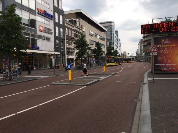
Fixing Shortland Street is something that I’ve been thinking about for a while. The issue came up again when my daughter came to visit me at work nearby. She can confidently get around the city by bus and cross awful streets like Dominion Road at Balmoral, but after lunch on Fort Street I asked her not to use the Jean Batten/High Street crossing, but instead go via Queen Street.
This is one of the busiest places in the country, our “High Street”, and people can’t cross the street safely.
Fixing this intersection has been the subject of ongoing debate. I heard a zebra crossing here was rejected because there are too many pedestrians. This is different than the other standard response of there not being enough pedestrians. Either reason for not providing a zebra crossing is not the correct answer to “how do you provide safer crossings for pedestrians,” This advice can be found in the US guidance Safety Effects of Marked vs Unmarked Crosswalks at Uncontrolled Locations:
It is important to remember that providing marked (painted) crosswalks is only one of many possible engineering measures that may be used at a pedestrian crossing to improve safety and/or to reduce delay. Appropriate measures depend on site conditions. Whenever considering how to provide safer crossings for pedestrians, the question should NOT simply be: “Should I provide a marked crosswalk or not?” Instead, the question should be: “What are the most effective measures that can be used to help pedestrians safely cross the street?”
Because the intersection is so busy and such an obvious barrier to people going from the waterfront/Britomart to the Shortland Street District and beyond, it has been called out to be fixed in the City Centre Master Plan as part of the shared street network. As an interim fix, large colourful circles have been added to the intersection to help raise the attention of drivers hurtling along the street. People have observed that the circles have raised the confidence of pedestrians, enabling them to step into traffic more often (or more boldly) to slow traffic. This seems like a less than ideal outcome and doesn’t take into consideration that most street users are not super agile and confident filtering through moving traffic.
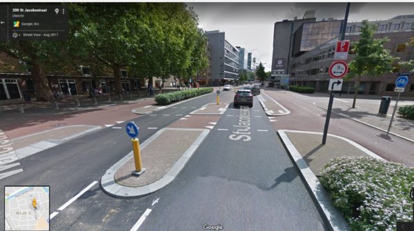
Below is my design. It is inspired by a street designer in Utrecht who explained to me that they don’t design for people to take unnecessary risks. In places where they expect pedestrians, AKA desire lines, they provide for them. Allowing people to float unprotected across painted medians between fast moving traffic lanes like we do here would be unacceptable to them.
This is how that approach manifests in designs. Below is an example of a pedestrian crossing at a very busy transit street in Utrecht. While there are signalised crossings at either end, this bus facility spans two city blocks so there are high pedestrian flows half way along where the city blocks are now closed off. The designers didn’t ignore the desire line or rationalise that pedestrians should use the signal, instead they provided for the movement by adding a raised protective island.
Crossing one stream of traffic at a time is becoming a standard feature of safe street design in the Netherlands. This can be observed in practice in Auckland. With CRL construction, crossing Albert Street is now a breeze. The signals to control the crossing seem ridiculous and are largely ignored. Another good point of reference is crossing Wellesley Street at Lorne Street. While the lanes are too wide there, it is pretty easy to cross. Here is another example in Utrecht. Note too that the medians are attractively designed, something we haven’t figured out yet.
Another feature of my design is a raised mountable median. The bumpy median, about 1m wide, narrows the lanes without having to move the kerbs. Vehicles using the street become confined. Large vehicles are barely able to squeeze through without rolling on the bumpy median. The road narrowing slows traffic and alerts drivers to the very narrow passage next to the pedestrian islands.
Currently, the excessive road space encourages cars to drive way too fast and sloppily. Speed bumps, or humps would be a useful addition. Physically slowing traffic here is key, something I’m not convinced the painted dots are achieving.
Here is an example of a mountable median which are often a feature of Cycle Streets but also can be found on busy urban streets (see also this post Wijkontsluitingsweg). 
The design assumes no changes to traffic. Removing traffic is an obvious and inevitable solution, but we shouldn’t have to wait for major traffic circulation changes or mega transport projects to improve city centre streets.
A few carparks are removed (dashed black srectangles) to allow for improved pedestrian circulation and to shorten crossing distances. Stretches of kerbside are re-allocated for passenger pick up and drop off (red dashed line) in an attempt to rationalise the chaotic traffic circulation. Raised islands are provided at key locations to let people seamlessly cross one lane at a time. The lanes next to the islands are very narrow, not much more than 3m wide.
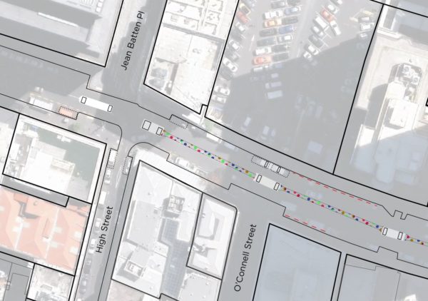
Here is a “tactical urbanism” version of the plan. Pedestrian islands can be set out using temporary traffic control materials and cones.
This concept acknowledges the heavy and fast traffic along Shortland Street. Conceptually, it doesn’t improve the subservient status of pedestrians, but vehicles are slowed and more confined by the lane geometry. This reduces the traffic turbulence and threat of vehicular violence.
Crossing one lane at a time using protective islands simplifies the crossing by letting people look for traffic in one direction at time.This design make it much better for all users including less mobile ones, and people who don’t have the perceptual acuity to deal with cars coming out of every direction.
It’s nearly 2018 – time to make our city streets safe for all users, especially in places where people vastly outnumber vehicles.
What do you think? How would you fix Shortland Street?

 Processing...
Nice post 🙂 your second traffic island from the left is going to need to be fully mountable to allow service trucks to turn into high street, but that is hardly an insurmountable problem.
Why would we not just block Shortland Street west of this intersection though?
The left corner is pretty round. Rubbish trucks already make that turn without using too of the middle of the street. But, yeah, mountable, or the island shifted a bit.
Closing Shortland Street at Queen Street would be too easy. I was trying to figure out how to make changes while not messing with traffic, which is pretty much a requirement of all street designs at this point in time.
Fair enough 🙂
This is the most alarming statement in the post:
“to make changes while not messing with traffic, which is pretty much a requirement of all street designs at this point in time.”
So that’s where AT are at, despite Vision Zero. Despite Goff’s instructions to reallocate road space to active modes and PT. Despite Council wanting a liveable city.
Seems to me this needs to be tackled head on.
If you want Goff’s plan implemented then this website would be best to lobby for the repeal of the part of the Supercity legislation that places AT as a stand alone entity which cannot be directed by Council.
Thank you Mr Hide!
That lobbying won’t happen of course given that a prominent member is also on the board of AT.
No members of the board. I think you mean because a prominent member is an unpaid advocate who donates his time to advise the board for free?
For the benefit of readers who aren’t familiar with Shortland St, there is already a traffic island to assist people crossing the street at 34 Shortland St (the right-most island on Kent’s diagram). Why they haven’t done *anything* at Jean Batten Place boggles my mind. Especially since the kerb treatments in that area signal to pedestrians there’s a crossing there. The spots may have changed pedestrian behaviour, but I haven’t seen them change driver behaviour much. Some are courteous. Others are not.
I feel the answer there is still “Just put in pedestrian crossing already!”, with or without additional treatments such as the mountable median or more traffic islands. I’ve been meaning to put in a LGOIMA request to AT about it… might follow-through in the New Year.
Good point about the existing island upstream, That works well, but it should be wider to make the lanes narrow.
I double-checked the island on the way to work. It has kerb build-outs to the car parking line, but that part of Shortland St is a bit wider than the Jean Batten Place intersection. I observed a couple of vehicles heading past it without making any adjustments to their speed. Anecdotally, vehicles seem more likely to pause to allow you to cross at the pedestrian island if they see you waiting, even though there’s no obligation to do so. Possibly because they know they only have to wait for you to clear their side of the crossing? If a driver pauses at Jean Batten Place, it requires either a gap in the oncoming traffic or co-operation from the drivers coming the other way.
I’m coming around to your way of thinking, but even with the road treatment, I’d still put in a pedestrian crossing combined with the island at Jean Batten place.
It’s easy to see how a zebra crossing would fit in at the western crossing on Jean Batten. I wanted the design to stand on its one, without a zebra.
I’d keep the dots Kent and cover the surface of each dot with white or red spray gravel and lift up the surface level of each dot slightly so that visually to 4-wheeled vehicles, those red and white dots can be easily seen as you approach them and felt as you cross them. For pedestrians, these red and white dots denote a large safe area to cross and for vehicles, its not only a traffic calming measure but better implies a pedestrian crossing without the need to deploy a zebra crossing. Its thus a measure to ensure a safe and intuitive crossing zone for pedestrians and a safe and intuitive zone for slowing down traffic on Shortland Street. Hans Monderman would approve.
I agree with you. I too like the dots and feel if they are raised they would work better. If they also to removed the parks from the street and make the sidewalks bigger. This would allow planners to put in better more defined crossing areasand mean that pedestrians don’t just cut between parked cars (what i currently do), it would also cut out park hunters – which seems to be the major issue in central Auckland. High-street should also lose its parks (and hopefully cars).
If High street became car free, Shortland street could probably cut down to one way and remove car parks and eventually go car free too. But the first steps to that is getting rid of the parking, then the utility of the street for drivers will drop – and eventually there will only be the need for deliveries in those parts of the city.
High Street bocoming car-free? What about the book store customers?? How would the book store customers possibly get to the book store?!?
/s
Presuming they have legs, the same way most customers visit retail stores. By walking from somewhere.
Yet, this mere fact does seem to be too trivial for those who think parking on the street is paramount for the survival of small business.
Alternatively, the early tactical version could use the red and white blocks that were on parts of the Beach Road cycleway when it first opened. IIRC they looked substantial enough to make vehicle drivers think twice about getting close to them, but of a size that could be moved fairly easily with a small forklift or similar to adjust their exact position – ie as adaptable as cones, but a heck of a lot more meaningful for drivers….
There was a whole pile of them at Beach Road – worth tracking down where they went? They were around 2m long, and about 750×750 square and laid on their long side.
I’m wondering if having pedestrian refuges wouldn’t actually lessen drivers willingness to let pedestrians cross. I say that because it fits with my own observations in that part of town. It also creates a sense of isolation, instead of inclusiveness. I agree that they have their place, Parnell Rise for example, but not when the area _should_ be fairly low traffic.
Cars go too fast on Shortland either because they’re in a hurry to get to I’ve no idea where, or because they’re coming down the hill.
Why not introduce speed tables even if just from the area of Fields Lane down? The place will eventually be turned into a shared space (and eventually a pedestrian plaza), won’t it? Get drivers used to slowing down. Force drivers to slow down.
One speed table @ Fields, half-height speed bumps @ Queen, High & O’Connell. Impossible to go fast without damaging your car, yet still allows couriers and taxis to do their jobs. The speed table _could_ be completed overnight – Though considering how long it took to complete the construction of the refuge on Fields Ln, no digging taking place, I doubt very much that it would take only one night.
Unrelated – It seems to me that a lot of drivers need to be reminded that pedestrians have right of way crossing driveways, further up the street.
Yes, I’ve observed the same driver behaviour, making this a bit tricky.
Queen Street is considered to be unnecessary for service trucks, and envisioned as a light rail, cycling and pedestrian only route. When this comes to fruition, Shortland Street will naturally end with a turn into High Street, leaving Jean Batten and Fort to become car free also. Of course this could be lifetimes away, given the glacial pace at which cars are being expelled from the CBD (on road carpark removal being the only weapon at present). In the meantime we need more planning from a pedestrian’s point of view, as once you are out of your car, you are just a pedestrian anyway. Perhaps some Dutch planners can infiltrate Auckland Transport and disrupt the dinosaur?
Perhaps we can encourage tactical urbanism to bring this forward?
First off, very much support this. But there’s one thing that I am struggling with – narrowing the traffic lanes with islands like this, without adding cycleways at the same time, creates pinch points for people on bikes.
This may well be okay in this particular location (?) – but in many other places, particularly where the islands are very isolated elements in a long wide road – this really scares me, and as Bike AKL’s infrastructure person, I have been pushing back on narrowing (below 4.2m) in these instances for years (while strongly supporting islands / single laning / raised crossings).
Not sure how to overcome that conflict…
I’ve thought of this. At this point, I think the overall outcome of slowing traffic is better for cyclists than imagining a pinch point for cyclists in plan view.
I don’t think it’s imaginary at all! But yes, on a case by case basis the benefits of narrowing may outweight the downsides. Not appropriate for your typical arterial though (without other measures / cycleways).
The thing about the pinch points – even on quieter suburban streets – is that they are a big barrier to the “interested but concerned” demographic. Until you learn to claim the lane, it doesn’t matter how quiet the road is, you’re going to get freaked having to cope with a pinch point. So designing with them doesn’t tick the box of encouraging new cyclists.
This to me looks like a case where we should slow the entire street down.
Those 4.2m lanes are the worst case, just wide enough for cars to squeeze past parked cars. If the idea is that cars can pass cyclists safely, then paint a cycle lane. If it’s too narrow for a cycle lane and a car lane, then the cars passing any cyclists will probably be sufficiently scary to keep the interested but concerned away.
+1, I’d definitely prefer 3.0m over 4.2m. A motorists thinks they can get through a 4.2m gap and will push through with less than a metre of clearance if you are riding left or get irate if you take the lane. at 3.0m all but the most violent motorists recognize that they can’t pass you.
Yes tricky. I guess as you kind of eluded to, where it’s slower traffic areas and not such a long straight length before them narrowing is OK.
Not tricky Grant – know need to narrow bike lane, narrow car lane
https://goo.gl/maps/yRFDFGGd4kw
The Dutch may not use the Vision Zero brand, they do understand ‘Life and health can never be exchanged for other benefits within the society’ and allow weaker road users space to be continued. This doesn’t remove other traffic. The Stronger just need to shares with care.
Here in Hamilton we see the opposite with the place for weaker remove to allow the stronger to have right of way. The weaker bad luck or good luck if the strong let you share.
https://goo.gl/maps/99KERwfURT42
I like this treatment a little further on, but it wouldn’t work for a roadway like Sandringham where the two-way traffic volume is too high. https://www.google.co.nz/maps/@51.9128339,4.3893305,3a,75y,143.81h,81.29t/data=!3m6!1e1!3m4!1sYBc892CYwL-UFzZKBxfzDw!2e0!7i13312!8i6656
The one you posted could work though as it explicitly conveys who has ROW.
Hello Lewis
I’d suggest example in your link is not user friendly, these are easily blocked, gravel collects at entrance (NZ roads), standard sweeper truck doesn’t clean them & Biking is a social activity, like driving with passenger, most people will want to be side by side.
Hello Peter,
I disagree. There is no difference between that being blocked and a regular bike lane being blocked, just go around. In the example, the roadway design is slow enough that it shouldn’t be too difficult to get around if that happens. If it’s a busier roadway, then appropriate design should be able to minimize that problem. Obviously it wouldn’t be appropriate on a busy road next to a warehouse or something where you’d expect movable objects to end up there frequently.
I thought about the cleaning aspect of it and that’s important. However, the separated bike lane I use every day isn’t much wider than the one pictured and it does not seem to have a problem with debris, despite being on the outside of a curve, separated only by bollards, so something must be getting done right. I don’t really understand what NZ roads have to do with gravel accumulation though…
As for the width, sure it’s a good goal to provide cycling facilities that allow people to ride side by side, we want a system that allows people to use bicycles as transport, not just for pleasure cruises. Just like the majority of utilitarian car trips are single-occupancy, most utilitarian cycle trips would be alone, and even for people riding together, it wouldn’t be a huge burden to pause the conversation for a couple seconds.
That doesn’t mean it’s the right choice for any given situation…
Pedestrian refuges can be a step up from no infra for pedestrians, but they aren’t ideal. Here are some downsides:
They are often not wide enough for a person pushing a pushchair or pram, and even if they are, put the person – and accompanying small child holding one’s hand – at one edge of the refuge instead of in the middle. One little wriggly dance puts that child in the traffic’s path. Let alone the problem if you arrive at the refuge at the same time as a zombie who doesn’t give you space.
If you are making your way around town with children on bikes, even if you’re walking your bikes, you cannot hold their hands. and you have to trust that they will stop on the refuge. Sometimes refuges don’t have space for a couple of children and an adult all with bikes, so the adult has to cross one child at a time.
I much prefer proper pedestrian crossings on raised tables, and a reinstatement of the culture that drivers must drive slowly near a crossing, and stop for anyone on it or waiting to cross. I think an AT advertising campaign about this, coupled with new proper pedestrian crossings, is really important.
+1
The pedestrian island must to be able to “store” a person with a bike, or with a pram as the starting point.
Many of our older refuges are quite skinny. Better ones ~1.8m or more depth – can feel more roomy and okay. Even on a bike (1.7-1.8m long).
One of the key downsides to raised tables (which I recommend everywhere I can!) is that they cost anything from 3 to 5 times as much than a refuge. Or more, if stromwater issues are created. So if you have a budget X and thousands of crossing locations to improve, do you do several hundred, or just 50?
[Yes, I know the answer is: Increase the walking/cycling/safety budget. But even if we do – hopefully in the new GPS! – we will be playing catchup for decades, which is why i feel the cost question – higher quality versus more quantity – is not irrelevant].
Is there another solution re budgets? Can money be found from another part of AT? AT are supposed to be providing safe infrastructure for all road users. And what’s the situation where road works are being done for another reason – does the Walking/Cycling Budget have to provide money for raised tables in this case?
Seems to me the Cycling and Walking Budget should be used for off-road purposes, and the other teams at AT should be providing safe infrastructure for all road users out of their own budgets.
I don’t disagree with your recommendations – but retrofits where no works are planned for other reasons for years or even decades will still be many thousands and thousands of locations…
So yes, it is a matter of how much we value (and fund) such works. But there is always a fixed amount of money. I guess what I am saying is that sometimes I WANT three things done good rather than one thing done awesome. The problem then becomes for me what defines “good (enough)” and what is just “half-assed”. I wrestle with that all the time, and I guess so do AT.
And of course it is always sexier to point at one high-profile awesome project, rather than say “we did all these okayish ones instead”.
All that said and done, I think this particular Shortland St location actually IS worth “awesome” because of its particularly high profile and user numbers. I was just getting side tracked into a general discussion because I can’t resist it 😉
I regularly have to turn my buggy sideways at pedestrian refuges to feel that both baby and I are safe from the traffic either side. Attention to this issue would be a befit to parents of small children. That and people, contractors not leaving wheelie bins right in the middle of narrow footpaths.
Close off vehicle traffic between Queen Street and both Shortland Street and Fort Street. This would mean anyone coming down Shortland St would have to tackle High St or the Fort St maze, I imagine this would make traffic disappear quite quickly!
I hate the idea of encouraging traffic to use High st. Wouldn’t it be better to “encourage” cars to use Fields Lane? It’s at the edge of anything useful and only goes to a handful of car park buildings…
Like this in Mokoia Rd, Birkenhead. These crossings are about every 50 metres and there are 4 or 5 through the town centre.
Bit of a mess down there due to the convergence of intersections. You have the cars queing to turn into Queen St, cars wanting to cross Shortland St to right turn into High St, and cars wanting to cross the lane to turn right into Jean Batten Place. Plus a bucketload of pedestrians due to the concentration of office space and dining/retail etc.
I think the dots have improved driver behaviour but overall there’s more that could be done.
As a pedestrian I like pedestrian islands, build outs, lane narrowing etc. As a cyclist I really dislike them. On my regular cycle commute the pedestrian islands are regularly the most dangerous part of the trip, as cars try and squeeze through the gap alongside me, or overtake just before them and then dive across in front of me to get through the gap. As I cycle reasonably quickly the effect of these islands on the approach extends a considerable distance.
Yes, I am very torn on these things. The one on Sandringham Rd at the businesses by Burnley is the bane of my morning commute. Always timing to squeeze between the constant stream of cars. I find a mirror to be extremely helpful.
But if it wasn’t there, pedestrians would almost never get across. Sandringham is woefully short on signals, so the continuous traffic and great width make it quite onerous for crossing, except at that pinch point where drivers actually stop to let people across.
Yes, I have this problem too. I think the solution that solves problems for both pedestrians and cyclists in this area is to make a one-way system for cars. Halve the amount of space given to cars. Once Queen Street is car-free, there will be no need to drive that last bit of Shortland Street and I’m sure a one-way network can be worked out for the area. Still keep a few loading zone parks. Have pedestrians only have to cross one lane of cars. Have proper cycling infra. Use some of the road space where possible for extra footpath / seating to make it more of a destination.
What’s to lose?
That would work. A simpler fix for the short term may be to add the islands as Kent has drawn but reduce the speed limit still further, to 20km/hr. Maybe add raised tables at the crossings too. Then cars would (should?!) be less likely to try and overtake cyclists, and pedestrians will find the road easier to cross and more appealing to walk down.
What you’re describing there though is not the effects of islands and buildouts, but rather the effect of POORLY DESIGNED ones. For example, our pedestrian design guidance makes it quite clear that the minimum gap between these solid treatments should be 4.0m and preferably 4.5m, i.e. enough for a motor vehicle and bike to co-exist safely.
I quite like the alternative though of swinging the bikes behind the back of a kerb buildout to bypass a pinchpoint, although it does require ensuring that cars can’t park up close to them…
Me and my bike are a bit over half a metre wide. A Ford Ranger is over 2m wide. So given a 4m spacing the driver of the Ranger can’t leave the required 1.5m gap, even if he drives right up against the island. Even at 4.5m it’s tight. And at 4.5m wide the gap is no longer pedestrian-friendly and will do little to slow cars down.
I don’t even care that much if cars get close if they’re slowed way down, and prefer to let people get through rather than having them lingering around back there slowed down, but about 1 in 10 blaze past at full speed, so now I have to take the lane through there and block everyone. I’d probably prefer if it were more narrow so nobody can get mad thinking they could have gotten by if only I wasn’t hogging the entire road. Also, if I ride far enough over to let cars go through, that puts me in the door zone of the parked cars on the downstream side of the pinch (on the specific example I mention above), which I cannot correct if there is a stream of traffic next to me.
GlenK, I would be interested in seeing the references for the development of the guidelines. The way drivers interact with the road, I always feel like it is a merge whenever the road narrows, even where there is still enough room for a bike and car together. If I’m merging either way, or I’m forced to take the lane, I’d rather it be so narrow that cars always feel inclined to slow down whether I’m there or not.
There is no required 1.5m gap, and a mandatory law would require 1m in urban areas. As mentioned, lower speeds mitigate the risk. I agree that a very narrow crossing point where it was clear that you couldn’t pass a bike is the other design option, it’s the ‘in between’ widths are problematic.
Hello Lewis thanks for reply at 6:16pm
Here are two references on width
1. UK Sustrans Design Manual. (p17) Streets and roads 8. [roading] Point narrowing: avoid widths between 3.1 and 3.9m. https://www.sustrans.org.uk/sites/default/files/file_content_type/sustrans_handbook_for_cycle-friendly_design_11_04_14.pdf
2. Here is information stating the Dutch, Copenhagen & Berlin cycle lane width of 2m is a good bike lane width & explaining way. http://hamiltonurbanblog.co.nz/2017/11/a-good-one-way-cycle-lane-width/
Disappointed GlenK says in NZ 1m is law? Doesn’t appear to allow much for wobble / normal human behaviour.
Hope this is helpful
Hi Peter, thank you for the links. I will look into them when I get a chance here.
Thanks to you all for the interesting conversation. I’m disappointed by the 1m law too, and also note that I’ve never heard of a motorist being pinged for driving too close to a cyclist. I imagine it’s one of those laws that only comes into effect if someone dies, and then not really because there’ll be no witness to what actually happened…
Heidi, I think what GlenK meant is there is no current law about minimum passing distances- there is just this recommendation in the road code
“…Because of this, give cyclists plenty of room when passing them. Ideally, allow at least 1.5 metres between you and the cyclist.”
http://www.nzta.govt.nz/resources/roadcode/about-other-road-users/sharing-road-with-cyclists/
Glen, I have never heard 1m in urban areas before- where is that from? I’m disappointed if anyone is advocating for it, given that most of our urban areas are 50km/hr, and that most drivers couldn’t accurately judge 1m on their near side anyway. I agree that lower speeds mitigate the risk but it’s not much less intimidating.
Peter, interesting that UK Sustrans advises against gaps between 3 and 4m- this seems to agree with what Glen is saying- either make it so narrow cars can’t pass, or so wide they can easily. The problem with the first of those options, as I said before, is that cars will try to get in front before the gap.
Personally i prefer raised table crossings, both as a cyclist and a pedestrian. If they are much more expensive, as someone elsewhere on this thread has said, maybe a cheap ‘bolt-on’ solution could be found.
Summary here of the 1.0m / 1.5m passing rule recommendation (although I see it’s now 2 years since this was being looked at – possibly needs updating):
http://cyclingchristchurch.co.nz/2015/11/13/mythbusting-what-a-safe-passing-rule-means/
Thanks for linking that article, and very interesting that you can go over the yellow dashed lines in order to pass a cyclist.
The coloured circles have made nil difference to traffic speeds. Put a 20 kph limit at lower Shortland st, extend the cobblestone area right across the street from O’Connell st to Queen st, add some speed humps and street furniture, replace parking with loading zones, as there are off street car parks everywhere! Remove the extra turning lane into queen st.
Really really need to limit access to Jean Batten Place! I’ve sat on the benches there and a large proportion of vehicles are through traffic, using it as a rat run to get to Customs street. It is chaotic and would be a much nicer place without that. The “Shared zone” with 5 kph limit is ignored. Can someone tell taxi drivers that “shared zone” means if someone is walking in front of you, then getting past isn’t a priority at 5 kph!
Put a 5 metre long loading zone (not a taxi stand!) at the Shortland street end of Jean Batten place, for delivery vehicles, and then a set of timed retractable barriers that are open for through traffic at certain times, e.g. 8 pm to 8 am.
Why not just put bollards/parklet up at the southern end of Jean Batten and western end of Fort Street. No vehicle ever needs to travel through, so ban them from doing so. They can come in from Customs Street and leave the same way.
Yes, you could choose one street off Customs Street to give access to Fort St, and block all the others from Customs Street at a point just north of Fort St, too.
That is the easiest fix by far. It would solve 90% of the problems right there. So you can guarantee AT won’t do it. They will come up with some elaborate scheme costing a lot so that they can preserve as much for cars as possible.
I really hope the new CEO makes a difference. It is all too slow and too cautious.
That is such a good photo at the top, Kent. 🙂
The other good thing about the pedestrian islands would be that it would stop the current dangerous practice of vehicles racing down the right hand (i.e. wrong side) of Shortland Street to get into Jean Batten Place. This is turning into a very popular rat run and of course most Aucklanders have no problem risking the lives of vulnerable road users to shave 30 secs off their journey.
A few weeks ago I saw a van driver race down the right hand side of Shortland Street and career round the corner into Jean Batten. It was obvious he had no idea Jean Batten was a shared space and was shocked that he had to slam on his brakes as someone was walking in “his” space. So of course, like all Auckland drivers, he immediately started beeping at the pedestrians to get out of his way. It was a frightening sight and I am still amazed no one was hurt.
I have written to AT repeatedly telling them that when (and it is when, not if) someone dies or is serious injured at this intersection, it will be 100% on AT and its lack of willingness to protect the most vulnerable road users. No reply of course. I would encourage other people to do the same.
The best way to get action would be if there was a legal decision that the AT board directors were personally liable under the new Health and Safety Act for the safety of people using AT’s “work place”, the road.
Unfortunately my reading is that the act does not currently apply, but I can guarantee if those people had personal liability there would be changes at lightening speed. Right now they can ignore the increasingly dangerous road environment their inaction is creating.
Have the zebra crossing with traffic light that works when u push the button and it change to red then when they get right a cross then it go Green
That’s ideal. And even better if the crossing is raised above the road level.
The real catch here is that traffic patterns are changing, but slowly. Eventually, High Street will change, Queen Street will cahnge, then a simple, sensible arrangement can be put in. But until the City Centre Plan, and the changes to these streets, is agreed, the Final Layout is still uncertain. So we need cheap, simple measures that can be put in, with value for money for teh time they will be there, which is what Kent is trying to do. The dots were a very cheap starter, but clearly we all think a bit more than that is needed soon.
The bigger solutions will require a lot of engagement and debate (this is the middle of the city, after all, and a lot of interests do have to be considered). But inexpensive measures can be put in, with a life of “until something else comes along.”
The mountable median strip does have a lot of benefits, needing to be rough enough that drivers don’t really want to run along, but are willing to use it to pass a slow, uphill person on a bike. It takes the sting out of pinch points, as it doesn’t push the bike into the path of teh vehicle, but requires the vehicle to move to the left – and not like the Hamilton example of a traffic lane just ‘wobbling’ around a refuge, with the shoulder ending.
A total change of look, perhaps from Fields Lane down, could bring a slow speed zone in now, to emphasise that different character applies, with teh chepest features for now.
The refuge islands are difficult, as good locations are hard to find, with service truck turning to include, and still a lot of parking. Perhaps just raised, mountable median at key points (Kent’s islands), joined by coloured median strip, and possibly refuge or traffic fully raised islands anywhere practicable would do.
The balance between not pinching people on bikes and being able to discourage fast over-running and wrong-side passing is going to be difficult, but tactical features that can be tried and adjusted would answer the questions empirically.
In my opinion the first solution is to cut back the speed limit to 30 kmh and add in traffic calming, particularly in the vicinity of Jean Batten Pl and High Street.
Secondly, there should be more traffic islands (even better a marked pedestrian crossing) and some of the on street parking needs to go, with disabled parking and loading zone parking taking precedence.
Thirdly, I’d like to see most of the west end of Shortland Street become a shared zone, which I can only assume will happen once High Street does the same thing.
I had previous sent a request to AT and below was the response I got:
”
Dear Kelvin,
Upon receiving your request, one of our traffic engineers has assessed the possibility of installing a pedestrian crossing on Shortland Street. Several factors are carefully considered prior to implementing a pedestrian crossing; such as the pedestrian demand, pedestrian desire line, traffic volumes, crash history and proximity to driveways and side streets.
It is important we undertake this type of assessment as under rules established by the New Zealand Transport Agency (NZTA), pedestrian crossings should only be installed where pedestrian numbers and traffic volumes suggest they are warranted. The underlying concept behind this requirement is that unless the crossing facility is well used by pedestrians, drivers will not expect pedestrians at the location concerned, and their awareness and attention of the pedestrian crossing will decrease. Furthermore, pedestrians naturally feel more confident crossing at a pedestrian crossing and can take less care than they would were there no facility. Combined, these two aspects can have the adverse effect of the facility becoming a dangerous crossing point. This concern is supported by research and as a result it is recommended practice that pedestrian crossings only be installed where pedestrian number thresholds are reached.
We have visited the site concerned and while we appreciate your concerns and agree a crossing facility could improve the amenity for pedestrians in this area; unfortunately the site characteristics cannot accommodate a pedestrian crossing. We have been unable to identify a location where a crossing could be installed without interfering with access to and from side streets and would still be on the pedestrian desire line. It should be noted that the traffic signal crossing at the intersection with Queens Street is less than 60 metres away.
We are unfortunately unable to proceed with your request at this stage.
We trust the above addresses the issues you have raised and appreciate you taking the time to bring this matter to our attention.
Kind regards,
Shaye Davids | Auckland Transport
”
(May 2016)
Hmmm. Which is the more important word in the following sentence – “unable” or “interfering”: “We have been unable to identify a location where a crossing could be installed without interfering with access to and from side streets”
Bow to the almighty Traffic God again.
That response is pretty confusing. Anyone who’s spent any time at that intersection will know that pedestrian volumes are more than enough to justify it. So the issue had to be side streets. Both High St and Jean Batten Place are one way streets leading away from Shortland St, which reduces the side-street movements to 4: left and right turns into High St and left and right turns into Jean Batten Place. So the only concerns would be right-hand turns into HIgh St (if the crossing is placed on the Queen St side) or Jean Batten Place (if it was placed on the uphill side).
More keen than ever now to send out that LGOIMA request.