This is a cross post from our friends at Bike Auckland
…at least, they do in this current consultation by Auckland Transport, which focuses on making it much easier and safer to ride between the surrounding areas of Stonefields, St John and Point England to Glen Innes. A veritable octopus of protected cycleways radiate from the town centre and train station, bringing the area to life for regular bike access.
This is one of the last projects in the 2015-2018 Urban Cycleways Programme. After some high level ‘what would you love to see’ public consultations, and discussions with key stakeholders like the local board and ourselves, this is the first public view of the proposed routes and cycleway layouts to be built.
The short version: the proposed protected cycle lanes will make riding much safer. And having lots of routes radiating from the Glen Innes Town Centre – as opposed to pepper-potting them here and there – will help create a highly functional, highly visible success. At the same time, these routes create access to schools, sports fields, parks and destinations around and outside of Glen Innes itself – a major bonus.
Our key remaining concern is that the proposals risk being watered down – especially around intersections, or where car parking is proposed to be removed – so we need as many of you as possible to support this project!
Consultation is open until Wednesday 25 October. When you use AT’s easy online feedback form, feel free to consider our takes on the questions:
1. Would the Links to Glen Innes Cycleways encourage you to cycle more often in the area?
- Yes! Yep. Yessirree Bob. Right?
2. What do you think of the cycleways?
- Support the solid separators that cannot be driven over, and sufficient door buffer space beside parking
- Support removal of parking where needed, so cycleways can be safe for beginners, children and casual riders
- Support the fact that routes radiate out from the town centre (i.e. starting in the middle and extending as far as budget allows)
- Support for improving hostile intersections, particularly the Big Four: the roundabouts at Merton Ave / Apirana Ave, Apirana Ave / Pilkington, Merton Ave / Morrins Road, and Taniwha St / Line Road
3. How would you improve the cycleways?
- A great place to mention any local knowledge or concerns or priorities you may have
4. Do you have any other comments or suggestions about the Links To Glen Innes Cycleways?
- Consider NOT upgrading the rail underpass north of the train station to become a cycleway. Why? Because the significant costs for changing the tunnel could be better spent on the other cycleway and intersection improvements proposed; and there are alternative routes.
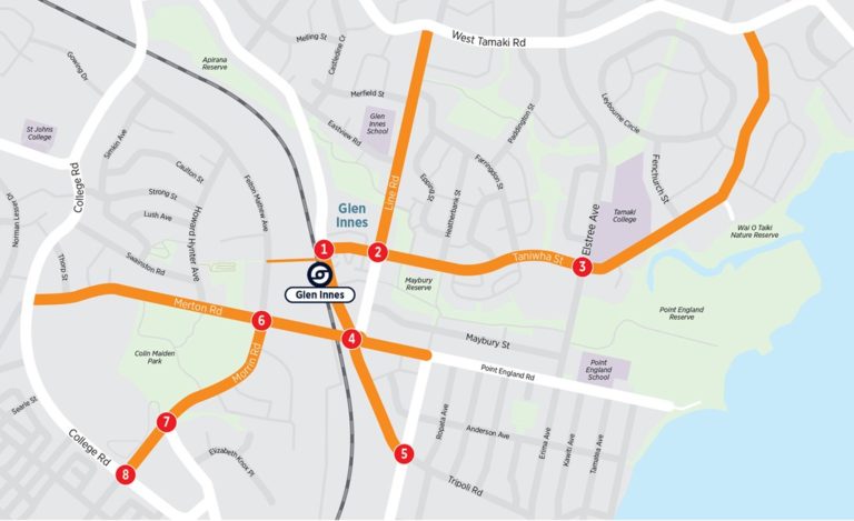
Where Will You See Cycleways?
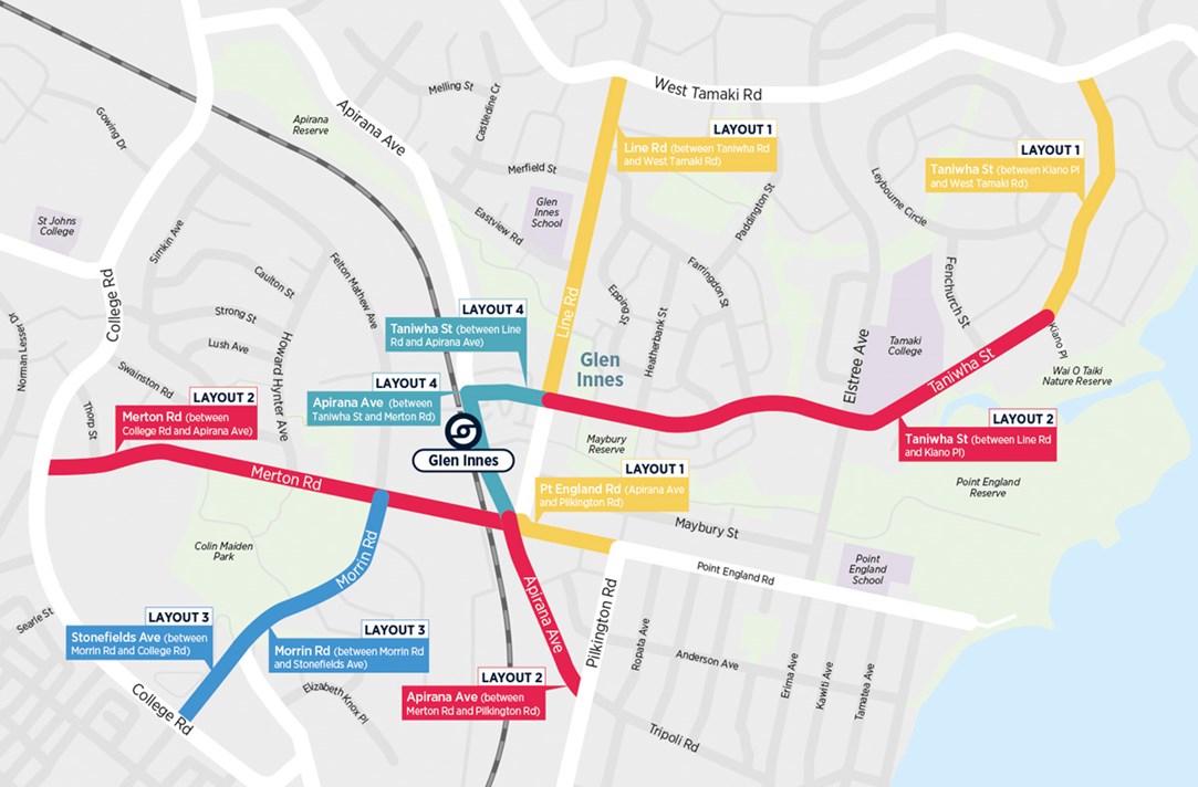
As you can see from the map and on Auckland Transport’s project website, the proposed cycleways radiate out in lots of directions and for quite long distances:
- In the west, people from St Johns will get a better ride, whether heading to the town centre itself, or to Colin Maiden Park – or maybe to get groceries from the supermarket at Felton Mathew Ave!
- From the southwest, Stonefields will similarly gain a safe connection to Glen Innes – which includes the train station, and the GI-to-Tamaki Drive cycleway for the longer-distance riders!
- In the southeast, the southern parts of Glen Innes and Pt England (in the direction of Panmure) will see a cycleway along Apirana Avenue, plus crossing improvements at the horrid roundabout near town centre.
- From the east, a short gap is closed between the existing (paint-only) cycle lanes on Pt England Road and the town centre and the other new bike facilities.
- In the northeast, Taniwha Street will give all the riders from the old and new houses to be built in this area better options for riding to schools and shops.
- Same applies for Line Road to the north, which also has a school along the route, so this will support a range of bike trips from commuters to shoppers to kids.
- In the town centre itself, all of this is tied together with cycleways on Apirana Avenue and Taniwha Street.
- Additionally, the walkway between Felton Mathew Avenue and the Glen Innes train station (including the underpass) will be widened to 3m and become a shared path, to cater for people on foot and on bikes.
First questions: Will all these cycleways be built as part of the first stage? Is there enough budget to do it right?
We discussed this with AT in our meetings. Our suggestion was that they should concentrate on routes closest to the town centre, and on higher levels of protection. (Some of the initial concept options had paint-only routes and shared paths, partly in an attempt to stretch the budget over greater distances).
But we felt – especially where parking was to be removed – that it would be foolish to engage in all the vocal discussions that parking removal causes – only to end up with a low-standard cycleway. Without physical protection, any new lanes would end up attracting only very few new riders. Our take: when in doubt, go for quality, rather than (a bit more) quantity.
AT seem to have mostly come to the same conclusions, as you’ll see when looking at the designs chosen for the various routes.
So what cycleway designs are proposed?
As there are a large number of different roads in this consultation, AT have grouped the proposed designs under four different Layouts, 1 to 4. Each section of street then is assigned one of the four layouts.
Likely because each of the streets under the same layout still have somewhat different widths, AT have not provided exact dimensions for the cross-sections. This makes commenting on them a bit harder – on one street, the protected cycle lane might be 1.8m wide, on the next 1.5m wide. We’ll see if we can get more detailed information over the next weeks.
This has also already led some people to query on social media – particularly when looking at the 3D images – the level of protection provided by the low separators, and whether there’s enough door zone buffer to protect people in the bike lanes from car doors opening. The 3D images seem to understate the level of protection somewhat.
Again, we’re seeking more information to share, but we understand from our discussions with the project manager (and we will be making a submission to ensure) that:
- The solid separators will be substantial enough they can’t be driven over casually or at speed
- If a car is parked against the separators, there will be enough space that a rider in the cycle lane somewhat closer to the kerb – not hugging the kerb, just staying generally left! – will not be in danger. In short, while the current renderings don’t show a door buffer zone, there is one. (How this zone will be marked is still to be determined.)
Below, we’ve copy-pasted AT’s description and designs – with Bike AKL’s take in Lightpath-colour.
Remember to also check the overview map to see where each of these layouts will be used.
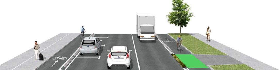
Layout 1
One-way cycle lane on both sides of the road with the possibility of recessed parking.
Physically separated one-way cycle lanes on both sides of the road, with some parking spaces retained. Where the cycle lane crosses a driveway, a small speed cushion will be installed parallel to the road, so vehicles can still get through while ensuring safety for people on bikes.

Line Rd – between Taniwha St and West Tamaki Rd
Some trees will be removed to provide space for the cycleway. They will be replaced with native trees. On-road parking along both sides of this section of Line Road will be removed, with the possibility of recessed parking being investigated between 71 Line Road and Morrison Funeral Directors. Some parking close to side street entrances will be removed to improve visibility for all road users and to create space for a turning bay for vehicles turning right into side streets.
Taniwha St – between Kiano Pl and West Tamaki Rd
On-road parking along both sides of this section of Taniwha Street will be removed.
Point England Rd – between Apirana Ave and Pilkington Rd
On-road parking along both sides of Point England Road will be removed
Bike Auckland’s take: Overall, a solid and simple design. Door buffers are not needed here, as no car parking is proposed in most areas. Where recessed parking is used, the cycle lane should go around the passenger (inside) side of the car, to avoid a break in the protection from traffic.
Even with some parking provided in recessed sections, we can expect some push-back against the parking removal, especially on Line Road and upper Taniwha Street.
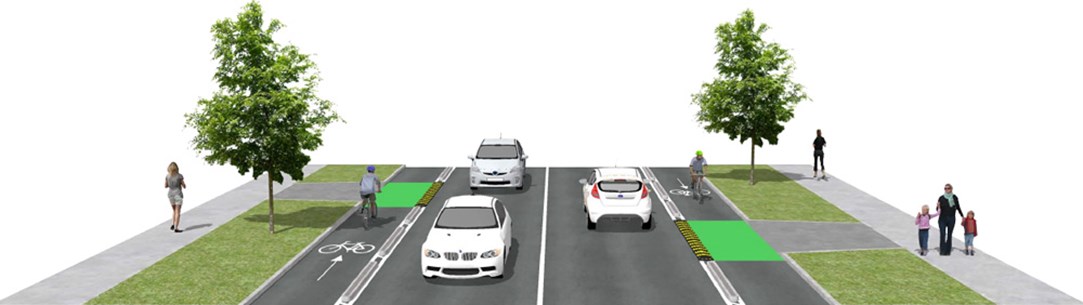
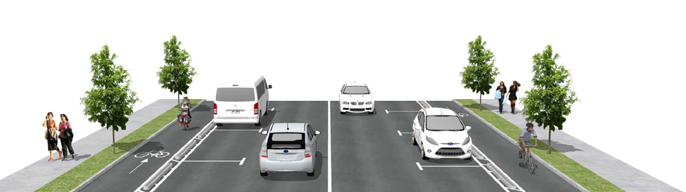
Layout 2
One-way cycle lane on both sides of the road with parking retained on one side.
A physically separated one-way cycle lane on both sides of the road, with parking spaces retained on one side of the road, between the cycleway and the traffic lane. Where the cycle lane crosses a driveway, a small speed cushion will be installed parallel to the road, so vehicles can still get through while ensuring safety for people on bikes.
Merton Rd
Due to the narrow road width under the rail over-bridge, the eastbound cycleway will use the existing footpath on the northern side of the road. The footpath will be widened and converted to a shared path to accommodate pedestrians and people on bikes.
Parking on the northern (eastbound) side of Merton Road will be removed, but parking will still be available on the southern (westbound) side. Some parking close to side street entrances will be removed to improve visibility for all road users and to create space for a turning bay for vehicles turning right into side streets.
The connection to the Glen Innes to Tamaki Drive Shared Path will be improved.
Apirana Ave – between Merton Rd and Pilkington Rd – parking on eastern side
The flush median will be removed and right turn pockets will be available at specific side street entrances. On-road parking along the eastern (southbound) side will be available. Some parking close to side street entrances will be removed to improve visibility for all road users and to create space for a turning bay for vehicles turning right into side streets.
Taniwha St – between Line Rd and Kiano Pl
Parking on the northern (eastbound) side of Taniwha Street will be removed, but parking will still be available on the southern (westbound) side. Some parking close to side street entrances will be removed to improve visibility for all road users and to create space for a turning bay for vehicles turning right into side streets.
Bike Auckland’s take: While the design looks okay, we will seek confirmation there’s adequate space next to the door zone. Crucially, this layout may also see push-back against parking removal on Merton Road and Taniwha Street in particular.
Apart from those aspects, we’ll be focusing on the treatment on Merton Road, where the Glen Innes to Tamaki Drive path begins. In particular, we’ll be looking the crossing to/from the westbound lane opposite the path entry. And, for the short section of eastbound shared path under the rail bridge, we want to ensure there’s some sort of separation from pedestrians – even if only via a kerb or painted line.
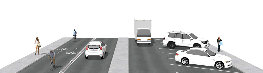
Layout 3
One-way cycle lane on both sides of the road with parking retained on both sides.
Physically separated one-way cycle lanes on both sides of the road, with parking spaces retained. Where the cycle lane crosses a driveway, a small speed cushion will be installed parallel to the road, so vehicles can still get through while ensuring safety for people on bikes.
Morrin Rd
The flush median will be removed and right turn pockets will be available at entrances to side streets. On street parking will be available along both sides of Morrin Road, but some parking close to side street entrances will be removed to improve visibility for all road users and to create space for a turning bay for vehicles turning right into side streets.
Stonefields Ave
One traffic lane will be removed from each side of the road on Stonefields Avenue between College Road and Morrin Road to provide space for the cycleway.
Bike Auckland’s take: who says that really wide roads don’t have their uses – like heaps of space to add cycleways! The fact that parking will be retained (respectively added for Stonefields Road) should make this one a shoo-in.
Admittedly, even without the flush median, we can’t quite see how the new cross-section fits in the current Stonefields Road section. Some carriageway widening maybe? Again, we will inquire.
Otherwise, we are happy with this design, which will make a massive difference to riding on what currently feels like a state highway.
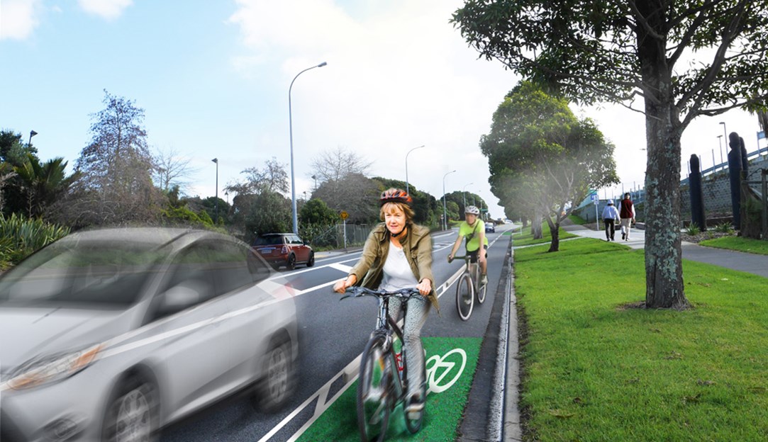
Layout 4
Two-way cycle lane on one side of the road with some parking retained.
A physically separated two-way cycle lane on one side of the road, with some parking spaces retained. Where the cycle lane crosses a driveway, a small speed cushion will be installed parallel to the road, so vehicles can still get through while ensuring safety for people on bikes.
Apirana Ave – between Taniwha St and Merton Rd – cycleway on western (northbound) side
The existing zebra crossing outside 244 Apirana Avenue will become a signalised crossing.
The existing bus stop outside the train station entrance will be upgraded to enable easier drop off and pick up.
A new bus layover will be located on Apirana Avenue on the western (northbound) side, opposite the Mobil petrol station.
A new bus stop will be located on Apirana Avenue on the eastern (southbound) side, requiring the removal of the parallel parking outside 294 and 296 Apirana Avenue.
The existing bicycle box storage will be replaced with a new bicycle parking shed that will provide more parking spaces.
The angled parking outside 244 and 260 Apirana Avenue will remain.
Taniwha St – between Line Rd and Apirana Ave – cycleway on southern (westbound) side with parking on northern side kept
On-road parking on Taniwha Street on the southern (westbound) side, outside 222 Taniwha Street, will be removed.
2 angled on-road parking spaces outside the G.A.S. petrol station on Taniwha Street will be removed, with 4 parking spaces still available.
Bike Auckland’s take: The proposed design of a two-way cycleway through this section is a (reasonable) compromise with the many needs of a town centre. It will provide a protected way to ride through the shops or cover the final metres to a destination in the town centre or to the train station.
As noted, we feel ambivalent about the widening and upgrading of the train station underpass to 3m and making it a shared path, as this could soak up a huge amount of money – especial when alternative routes are available and money remains very, very tight.
It may be better to simply improve the underpass, add CCTV, etc rather than rebuild it fully. Funnelling cyclists through an underpass that has 90-degree turn walkways to the train station platform would also need to be very carefully designed, or we may end up with yet another set of unpleasant zig-zag chicanes to slow cylists, a limited outcome at considerable cost.
Back to the main road cycleways through the town centre: At the ends of the Layout 4 section, riders from the two-way cycleway will need to switch back to the one-way cycleways, which brings us to…
…what about the intersections?
If you’ve ever cycled through the area, you’ll know there are many intersections – particularly roundabouts – that are very scary for people on bikes (and pedestrians!). Take the example below, just south of the town centre…

The good news is that most of these intersections are set to get improvements, as shown in the next map and AT’s descriptions:

Bike Auckland’s take: The good news is there are a lot of positive changes, in particular, the added zebra/cycle crossings, and the fact that ‘physically separated cycleways continue through the roundabouts’. Also, the reduction of Apirana / Pilkington and most of Merton / Morrin to single approach lanes, much more suitable for town centres and residential areas.
Pedestrians of all ages and speeds will benefit as much as people on bikes, something that can get a bit forgotten.
What’s lacking is detail – particularly for Apirana Avenue / Merton Road. With no proposed reductions of the multi-lane approaches, how will riders or walkers cross here? We’ve seen some early designs, but have no idea what is being taken forward. There needs to be safe crossing, or this will remain a major safety issue for everyone who travels along these routes.
Also: while we’re in favour of reducing the approach lanes, we really hope that those who tend to see the world from behind the steering wheel (whether residents, retailers, or passing through) will welcome this safety improvement. We’d like to think that everyone wants safe streets to walk and ride on – and no one wants to crash into pedestrians and people on bikes – but as we’ve seen elsewhere, the universal benefits of street upgrades can take a bit of time to sink in.
AT really needs to stick to their guns here, or the proposals could be watered down until nothing much happens. Your support will be key!
So in summary, there’s a heck of a lot of good stuff in here for pedestrians and all ages of people on bikes – but not everyone may see it that way, given it involves removing some on-street parking and changes to busy intersections. So we need as many of you to support this as possible.
Here is the AT’s online feedback form again – and be sure to read our short answers at the very top of the page!

 Processing...
Thanks Bike Auckland for checking it out and helping to ensure the best possible design.
“After some high level ‘what would you love to see’ public consultations, and discussions with key stakeholders like the local board and ourselves, this is the first public view of the proposed routes and cycleway layouts to be built.”
Was there any community education to forestall the resistance to parking removal?
Not aware of any – but there has been a bit of outreach in general as part of previous consultation stages (like this one https://www.bikeauckland.org.nz/help-make-glen-innes-and-environs-friendlier-for-people-on-bikes/).
I guess AT may well be worried about discussions about parking removal before they know where they are proposing to remove parking…
I think they need to tackle the issue head-on. I think AT need to run a huge advertising campaign detailing:
– the social, health and environmental objectives of urban cycleways,
– the space-hungry nature of cars,
– the better people-flow (ie customer-flow) efficiency of PT and active modes,
– researched examples of effects from parking removal that is part of a good urban improvement design including improved PT and active modes (and not just the parking removal to assist commuter traffic flow past a shopping centre that retailers may be more accustomed to.)
– Goff’s instructions to reallocate road space and why.
Without this, neighbourhoods become divided over the issue. Local design projects are stymied by misconceptions and misinformation.
“Our key remaining concern is that the proposals risk being watered down – especially around intersections, or where car parking is proposed to be removed – so we need as many of you as possible to support this project!”
AT should be leading here, not setting up a fight in an information vacuum and waiting for submissions.
I disagree that AT needs to run a huge advertising campaign to avoid intractable “car parks vs cycle lanes” or “car parks vs buses” debates. On the contrary, these are often best resolved locally. Residents Associations and Business Associations can and do play a role in elevating debate beyond a zero sum game.
If anyone has been to orly ave mangere they will see that when parking is removed and raised cycle lane separators put in, people park in the cycle lane. It ends up being worse than if no cycle lane was there. Cyclists have to ride in the car lane or on the footpath.
I don’t know what the answer is. Good luck getting Polynesian to comply.
Nothing like a bit of casual racism to completely ruin an otherwise great comment.
Business associations are strong at resisting the removal of on-street carparks; in suburbia at least. Where are you thinking of that they have elevated the discussion, BigWheel? From research, customers want safe and pleasant pedestrian amenity to walk to many shops once they have arrived at the shops (via whatever mode). A particular carpark outside a particular shop is unimportant to customers. Nor do the business associations seem aware that reallocating road space to space-efficient modes provides the business with more customers passing, and that cyclists tend to spend as much as car-drivers do.
Residents’ associations seem to be stuck in the “my rights are to park where I want” mindset, instead of seeing the rights of children to walk and cycle, or non-drivers to access their city via public transport. Let alone seeing the big picture of roads-induced car dependency and the proactive steps we need to take to reverse it.
So, who is left having to resolve these problems locally? A few concerned child-focused climate change-aware citizens wishing we had a bit more support from AT. I’ve been involved in too many initiatives ruined by stuck-in-the-mud non-research-based thinking to believe that local solutions will be found.
“Nothing like a bit of casual racism to completely ruin an otherwise great comment.”
You call that “casual”?
Heidi, have a look at Meadowbank and St Johns.. http://mbsjra.co.nz/ or check out their FB page. There’s often a range of views at meetings but none of the zero sum thinking you describe in your post. Quite the contrary. There’s even some evidence based research through online survey. As a result there’s lots of good stuff getting done: traffic calming, PT improvements, walking and cycling initiatives. Sometimes car parking gets improved too. It’s absolutely about locals solving these problems locally through collective engagement.
Or more broadly look at the OLB’s 2017 draft plan under the transport section.
Thanks for that, BigWheel. Obviously things work differently in different places. People who are engaged sufficiently to get involved with a business or residents’ association are usually caring about their society. My argument is that AT should provide them with information to help make informed decisions. Perhaps where you are this is happening anyway. Where I am, the proposed cycling and walking improvements project has had a kickback from retailers – with every retailer on the main road signing a petition to stop it. These retailers needed information. Instead they got local misinformation and hype.
The added complication is that the proposed cycling and walking improvements project has large negative effects on walkability! I’m working on a placemaking project for the towncentre at the moment, and we’re trying to improve walkability and retailer conditions, but AT’s project is sending it backwards. We’re wanting better conditions for retailers, better cycling and better walkability, but when the local community has a whole lot of misconceptions, and AT is single-tracked, some good AT-backed information would have come in very handy. It’s no use local people providing information to those who have already set their minds against something.
And of course, NZTA misinformation campaigns about road projects doesn’t help when a big part of the knowledge base has to be about awareness of road expansion and car-dependency.
Heidi I agree it’s tricky with all kinds of misinformation. And misperceptions.. no doubt my own included.
That’s one reason why it’s always good to hear and consider a range of views. Invariably you get better outcomes. The nightmare for any residents group is when a single voice or political view monopolises the debate. It’s a trap, whatever the issue, whatever your views on it personally. Why? Because the only thing residents have in common is that they live in a particular place.
So the Northcote RA has failed its residents by letting this happen over SkyPath. All of them, even those opposed to SkyPath. They’ve let them down by adopting a dogmatic (idealogic?) position, and whether SkyPath happens or not, they find themselves collectively ridiculed. So their views (on anything) get widely discounted.
Others have found themselves similarly captive in opposition to the UP, or a specific development.
On the other hand, residents know their ‘hood, their “place” far better than AT or NZTA or AC or advocacy groups like GA or Bike Auckland or whoever. That, and the diversity of views residents have that is their strength.
All the same residents aren’t experts. That’s another trap. In my experience they/we can be effective when we talk in terms of outcomes not solutions. “We need our kids to be able to get safely from this side of a busy road to school on the other side”. Not “we want a pedestrian crossing”. That’s what the transport engineers are for. Maybe the solution is something else like traffic calming.
When RAs (and LBs) nail their colours to the mast of a particular (technical) solution: “We demand a roundabout!” they lose credibility when a set of traffic lights goes in delivers the outcomes they wanted.
I don’t think it is a racist comment at all. It isnt racist to state a fact, even if a slightly gross generalisation. Unfortunately, commenting as a polynesian living in south auckland it’s a pretty accurate description of the problem. When I pass through the future streets in Mangere, there are any number of cars parked blocking the cycleways, rendering them useless. All the cycle lanes put in out in Manukau (Puhinui Rd etc), again filled with illegally parked cars. Enforcement just causes unnecessary hardship to very poor families. Give them tickets, they can’t pay. They don’t own houses so you can charge their rates bill, take them to court, they have no money to pay so you can’t get much from them and waste council time and resources for nothing.
Frankly, this is the result of clueless rich white people putting stuff into poor areas without any idea what life is like to live below the poverty line. For GI, it will just mean accelerated gentrification and poor people living in cars and caravan park slums. Just lovely. For the rich white folk, that is.
Yes, I think I agree with all that, BigWheel. What I would have liked to see is AT sharing information and hosting a forum for residents and local businesses to talk about their needs. If this had happened prior to the preliminary design, I think everyone would have felt more informed and listened to, and AT could have actually included the needs into the design. People accept a different design much more readily if they’ve heard other people expressing their needs.
I think it’s important to discuss AT’s process, as I’d like to see it improve. There are two main stumbling blocks at the moment:
1/ On Auckland’s roads, the road corridor isn’t wide enough for properly protected cyclelanes and busways or often even for one or the other – See my comment lower down in this post. This needs to be acknowledged, and a better Auckland solution found than, for example, insisting on keeping flush medians, insisting on putting the cycleway on the main road when other roads are possibilities, and sacrificing trees and footpaths to do so.
2/ AT basically expect bikelash and retailer kickback instead of trying to move the public’s understanding up a notch or two. People and organisations who put a lot of effort into analysing the project and suggesting better local solutions are swept aside in the same manner as the general misinformed bikelash. For example, the route is set in concrete at an earlier stage of the submission process. Local knowledge of alternatives is therefore unable to be fed into the process.
About Auckland’s road widths, I naively think “they’re wider than the European ones I’m familiar with”. I didn’t know what a flush median was until I moved here. You make an important point though: the footpaths are wide too, as are the berms, often much closer in to the city centre than you might find in cities that developed much earlier than Auckland. Then again, I doubt there’s many votes in cycle lanes over street trees?
I agree that AT tends to expect bikelash and retailer kickback, and that they shouldn’t. People’s views are far more diverse and nuanced. Local context is also far more varied than makes sense for a one-size-fits-all solution. I think AT and AC do hold pretty good local meetings and workshops. But inevitably they themselves have a high level perspective. They depend on good quality local engagement and insight. I’d argue they’re unlikely to draw out all the insights from one-off meetings. It needs lots of people to engage and think deeply about this stuff, over and over, for years, with a very long term view. Accepting the inevitable changes, even while not necessarily agreeing with them, to drive favourable outcomes for the neighbourhood.
Saying that, people don’t necessarily think of the upsides of change, or avail themselves of the benefits when they’re presented on a plate. Along Stage 1 of the GI-TD Shared Path, houses along Felton Mathew Ave back onto one of the best new cycling / walking / outdoor leisure facilities in Auckland. NZTA paid for and installed nice new backyard fences: tall, wooden ones to provide security and privacy. They also offered a lockable back gate (same height, matching style) so residents could access the Shared Path right from their back yard. Free of charge. Now they’re a few minutes’ traffic free walk or ride to GI train station, or St Thomas’s School and Selwyn College. What’s not to like? Now go check out how many took them up on the offer. Or rather, how few of them. There’s nowt as queer as folk.
1) The midblock layouts could be improved further if the parking was removed and a flush median provided instead which assists pedestrians and turning traffic. NZ has to move on from providing on-road parking. Too often we are trying to squeeze too many functions into narrow road corridors (Aside: NZ needs a new design standard for new roads so that the corridor are wide enough for all modes)
2) The mid-blocks are relatively straight forward. Its the intersections where there is less space and more conflicts.
3) Children don’t have the cognitive ability to deal with complex traffic flows – Adults don’t either exampled by the number of accidents we have. Personally I’d like to see all cycle road crossings & intersections use on-call traffic signals or speed humps on the road approaches. Its common practice where I am to provide speed humps on main roads in front of all ped/cycle crossings and to provide exclusive phasing for peds/cyclists at signals.
It’s great to see segregated cycle lanes become so common, “the standard” these days. A few years ago, before Beach Road/GGC/Nelson St, these were rare (non existent?).
For me, the next step to is to widen the separator between the cycle lane and carriageway – to provide more protection for cyclists, but also to improve safety where vehicles cross the cycle lane. There are many cases in Auckland where vehicles need to turn across the cycle lane (ferry terminal, driveways and especially car rental depots on Beach Road and Nelson St) but the cycle lane design is such that drivers don’t get a clear view of the cycle lane they are crossing.
This article covers this topic and I refer specifically to the first image which shows a nice wide barrier between motor vehicles and bikes, and providing vehicles with plenty of space off the carriageway to stop, look and proceed safely across the cycle lane:
https://bicycledutch.wordpress.com/2016/01/12/cycletracks-and-commercial-driveways/
Of course this requires more overall width of the road corridor, or fewer vehicle lanes, but it is something we should aim for where possible.
That’s a good link, Andrew, thanks. The available width of the road corridor is indeed a key consideration here. Given what we have, we’re not going to get good, well-separated and visible cycleways unless there’s an overt policy to provide them by reducing other amenity.
And then there’s providing busways, too. Basically, a buslane takes a traffic lane. A cycle lane with proper separation takes a car lane too. So only roads with three lanes (each direction) or two lanes plus parking will be able to be converted to having both a bus lane and a cycle lane, with one remaining lane of traffic.
If a traffic lane must be retained, I see the only solution here is to put cycle lanes on different roads to bus lanes.
Instead, the solutions being put forward are for cyclelanes without the required visibility, removal of berms and trees, bus lanes for only partial sections where there is space, etc.
“4. Do you have any other comments or suggestions about the Links To Glen Innes Cycleways?
Consider NOT upgrading the rail underpass north of the train station to become a cycleway. Why? Because the significant costs for changing the tunnel could be better spent on the other cycleway and intersection improvements proposed; and there are alternative routes.”
Huh?! That underpass is in desperate need of improvement. As is the Merton Reserve Path. Many people locally simply don’t use either path because of safety fears. Given them a break! And as for alternative routes…?! From the vast bulk of St John’s, you just told them they need to go 500 m further, along the busy Merton Road and through the miserable (and not much safer feeling) rail underbridge. 500 m! Ye gods, if that’s isn’t valuable what the heck is?!
Besides, all that NZTA land west of the railway track is surely going to be sold off and rezoned, and those people will need to get to GI station somehow. Or are they all going to head three sides round a rectangle as well?
If the GI underpass is widened out and made cycle-able it would go a long way to making it feel safe, and then it would be used more, which would make it even safer still, and so on..
Put it this way: if the GI underpass was a shared path that felt safe to use, practically *everyone* heading to/from the west would use it rather than Merton Road.
“Huh?! That underpass is in desperate need of improvement.”
Yes, but do we need to improve it to a shared path level – I haven’t seen costings, but I have my suspicions that that one underpass, if it was ripped out and rebuilt wider, could be half or more the total budget. For a link that already exists.
Seeing that cyclists will have safe routes along Merton to get to the town centre, I’d think we should spend SOME money on making the underpass less unpleasant for people on foot, but not break the bank changing it into a shared path which could really only be done properly by fully rebuilding it.
We knew that that comment was not going to be agreed by everyone, but when money is so tight, you got to make some hard calls. This is one we would back. Do things with more impact immediately, leave the harder, more costly things for later.
Except, Max, the very thing that makes that underpass so uninviting, so unsafe, is its size. It’s small, and has poor sight lines (hidden T right in the middle). Making it a shared path fixes that.
For the 1,000+ people living in St Johns this would deliver a 500 m traffic-free *safe* short-cut (whether walking or cycling) to their nearest train station. That’s *massive* ..it could well encourage decent numbers to get out of their cars.
This blog rightly rails against cul-de-sacs in favour of permeable grids. Direct routes for walking and cycling are game changers. It’s one of BA’s key measures isn’t it? It’s how the Dutch do it isn’t it? In my view, piercing the barriers to direct routes, whether physical or perceived, is strategic and always worth doing.
Seems to me the problem is the widening of the underpass should happen, but from another part of AT’s budget. Does the Local Board have a Greenways Fund?
I don’t disagree with anything you say. I just know that there is a VERY fixed budget, and I see this tunnel as, potentially, taking up not only a part, but a massive part of it. Building tunnels under railway lines can cost millions, in my experience.
The whole project being consulted on only has a few million (single digit). So unless there is separate funding available we are not aware of, I cannot see the underpass happening without essentially removing the funding for many of the other projects discussed in the blog / consultation.
I may be wrong, but it simply does not appear to be the highest priority for me.
Well I think you have to deal with the constraints and pinch points as a matter of priority: nasty intersections, dodgy underpasses, motorways, railways, rivers, whatever. Sort those out and build the first 100 m along each street, rather than 500 m or however far it goes.
At the end of the day, even building all the on-street facilities on the map doesn’t create a network. It all ends somewhere on a regular road elsewhere in GI, Pt England, St Johns, Glendowie or Panmure. But there may be lower cost ways of dealing with that. Lower traffic speeds for example. Aren’t they supposed to getting easier to implement sometime soon?
On the other hand there are no obvious other measures to widen a poky underpass than making it bigger. Go for it. Deal with the bottlenecks and the rest will follow, one way or another.
Any good engineering design looks at the “pinch points” first. Connecting them is far easier.
I can’t blame Bike Auckland for steering AT away from spending on this pinch point though. This is the problem with having to scramble for the UCF money. Trying to get the most done with a limited supply before it runs out means hard – sometimes actually ‘bad’ from the point of the view of best design – decisions have to be made or we’ll be left with a few quality intersections and underpasses and not much else.
Now, if the government was to tackle climate change, air pollution and road safety with an intention to actually change things, there’d be a lot more money in the kitty, and better design would be possible.
Heidi pretty much made the point – and I would agree with you if the underpass was the only reasonable way to get from west of the rail line into the area. But while for some (people living north of, say, Strong Street) the underpass would be more convenient, many others would in the future have the option of using Merton Road, with protected lanes each side (and a very short section of eastbound shared path under the rail bridge), and thus not actually have a longer or worse ride without an underpass that is not a shared path. So the underpass in my view is just not as central or absolutely required as you seem to feel.
If I am wrong, and AT has the money, or other sources of money, to do this – great! Lovely. However, after 3 years of steadily escalating construction costs in a boom period, and the lack of any new money coming in, I have often enough seen projects cut back in quality AND quantity. At those points, at project level, we have to ask: what should be most important?
Because as Heidi says: The question of “how much funding” is a separate one, a political one. Whereas this one specific blog focuses on the more more circumscribed “one single project” constraints of a specific consultation. Bike AKL keeps calling for more money on general terms too – but that will all be decided in the next weeks and months as government is formed and sets budgets, and not as part of this consultation…
I agree that the underpass should be rebuilt as a priority. I have some reservations using it as a fit male, my partner would never ever go near it. And the long way round is too long