Auckland’s city centre has improved remarkably in recent years. The likes of Wynyard, Britomart and our shared spaces have showed that Auckland is capable of making significant and world class urban improvements.
Now, the details have emerged of the council’s refresh of the City Centre Masterplan and the Waterfront Plan. They’re due to be approved by the council’s Planning Committee next week. They say the refresh “maintains the vision and direction of both plans, and focuses on the next phase of delivery“. This also follows on from our victory on Victoria St over Auckland Transport’s plans which would have killed the Victoria St Linear Park. The refresh covers 5 key areas.
- Downtown
- Waterfront Corridor
- Midtown Streets
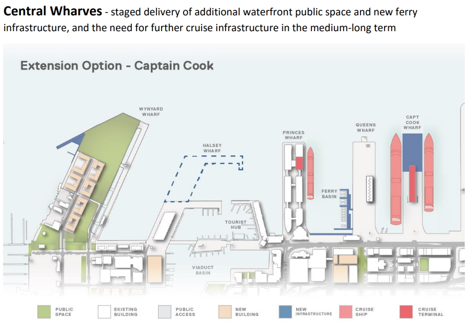
- Central Wharves
- Wynyard Quarter
Let’s look at them in more detail
Downtown and Waterfront Corridor
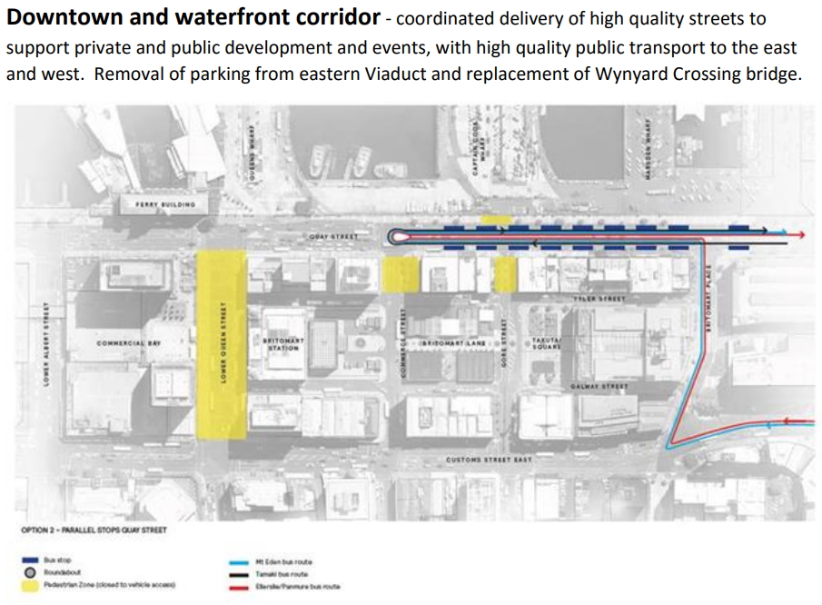
As part of ATs response to the midtown bus consultation, which resulted in the Victoria St Linear Park being saved, they came up with an option they call the ‘crossover’. At the time they said it involved “swapping some major bus route groups within the city centre” (more details on that later in the post). For the buses that travel to Britomart, AT are looking at building a new bus interchange on Quay St between Commerce St and Britomart Place. A roundabout at the intersection of Quay and Commerce streets, which I understand has affectionately been called the “bus ballsack”, serves to turn buses around and to punctuate vehicle movement along Quay St so that west of Commerce St can be converted into a shared space/more pedestrian friendly location. It will also allow for all of the streets within the Britomart precinct to become shared spaces too.
I’ve got a few concerns about this, including:
- People wanting to transfer to a Northern Express or other Lower Albert St bus could potentially have an over 500m walk to do so.
- By having the bus interchange on Quay St, it gives the buses that use it the same disadvantages that ferries have, that half of their catchment is water.
- The roundabout essentially takes up all of the space currently on Quay St between the buildings and the red fence. This could have major and serious implications for the popular Quay St cycleway.
- It’s hard to see just how reliable buses are going to be given they’re going to have to be competing for access to the roundabout with cars.
Here’s a prettier image of what’s planned.
![]()
Another bus interchange will be centred around Lower Albert St and will serve the Northern Express, Onewa Rd and North-Western Busway buses. This will effectively ring the block containing the Downtown Carpark, AMP & PWC buildings with a busway. As part of this, access to the downtown carpark would need to be changed (or the carpark redeveloped). AT also want to keep the vile Lower Hobson St flyover but narrow it down to two lanes with one each way.
The intention of much of this is to tie in the planned people space that will be built in front of Britomart with and improved Queens Wharf and much more people space along Quay St between Lower Albert and Commerce St, as well as an upgraded Te Wero island. Further west the Te Wero bridge is due to be upgraded or replaced, hopefully with something much wider.
You can also see in the images above Light Rail slipping out of Queen St and onto Customs St and Sturdee St. As I understand it, Sturdee St will become dedicated to PT while Fanshawe St between Nelson and Albert streets will cater for traffic in each direction.
Midtown Streets
As mentioned, the fight to save the Victoria St Linear Park paid off and AT came up with a new option they call the ‘crossover’. The map below is indicative at this stage but shows how the routes are intended to work. Routes heading to the city from Newmarket will turn down Grafton Rd, on to Wellesley St to Wynyard while isthmus routes will use the Quay St facility above. The two NEX routes will use either Lower Albert St or Wellesley St and turn around in Grafton Gully which is being called a new ‘University Station’. There are no details on just what that station entails.
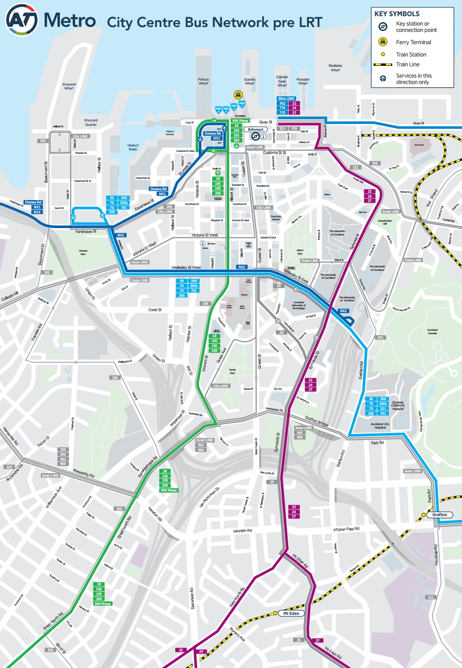
They say this will enable them to deliver two great city streets, the Linear Park on Victoria St and a bus boulevard on Wellesley St.
Central Wharves
The main element of the Central wharves is the public realm improvements to the Ferry Basin, infrastructure to support a future doubling of ferry services. A mooring dolphin to allow longer ships to berth.
The Halsey St extension has been talked about for a while in relation to the America’s Cup in 2021. However, the report says there’s no intention at this stage to bring it forward
Wynyard Quarter
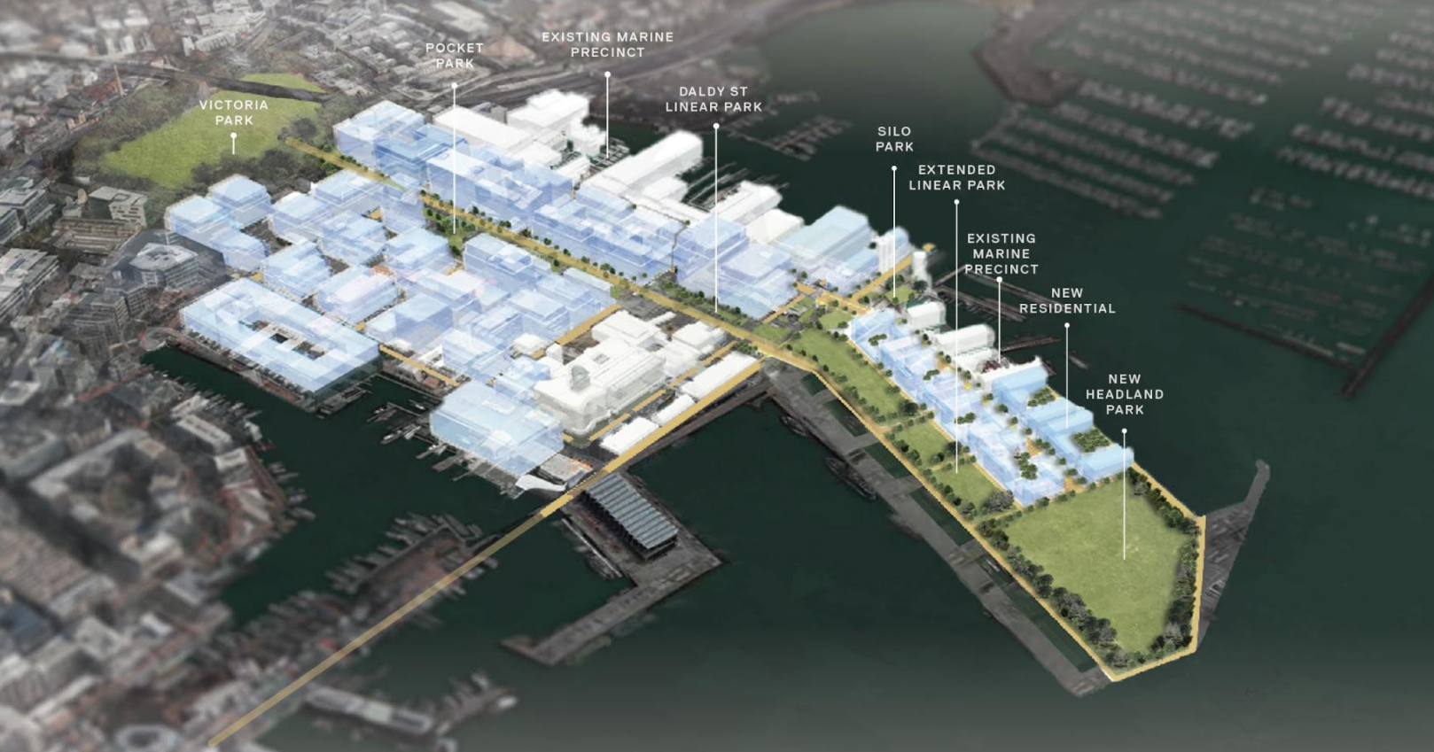
At Wynyard the plan is to extend the Daldy St Linear park to connect up with the proposed Headland Park. It doesn’t mention it in the report but it would create a linked park/urban space all the way from the Domain through to the tip of Wynyard Point. They also say they’ve dropped plans (at this stage) for a “signature public building”.
Overall there are some good proposals and it’s exciting they’re moving closer to implementation. However, I do continue to have some potentially major concerns around the crossover option AT are touting.

 Processing...
Do AT ever get anything right?
A roundabout on Quay Street?! I wonder if they’ll position a full-time security officer there, like they do for the Queens Wharf roundabout (to tell people to watch out for the roundabout).
Hey speaking of the development of the wharves, I quite like this idea which extends Halsey St wharf into the shape of a silver fern when seen on google maps: http://imgur.com/a/NjOOC
“Improved remarkably”
Such a statement I think deserves a little more evidence! Has crime dropped? Has visitor/tourist satisfaction climbed? I’d like to know exactly what has improved.
If my son goes from a C to an A in social studies, he has improved. If there are no grades/evaluations, there’s no sense in saying the same
…and how many all wether playing fields are the putting in?!?!?!
Victoria Park is actually pretty good at dealing with rain!
These days he should be trying for an E. If he gets an A that is called Achieved which is the equivalent of what we used to call failed.
Do you measure everything in your life!?
Retailer and pedestrian satisfaction in the O’Connell St area was measured and it has improved. Retailer takings in the Fort St area have been measured before and after the improvements there, and are well above background levels. Pedestrian numbers and the amount of ‘sitting to enjoy the area’ have been measured in the Fort St area and they have increased. Also the proportion of people in the Fort St area who have come from the wider Auckland area has increased, showing the appeal of the area has increased rather than it just being a through-route for people who live and work locally.
Why don’t they just run the Symonds St buses through customs on a right of way? Customs is a very wide street. Reduce it to one way each way for cars.
But the precious cars Matthew wont someone think of the cars
Yes the cars we need to give over the city centre to… of course we have a motorway ring of the city centre so it’s not 100% clear why anyone actually needs to cross Queen St in a car…
Agreed Matthew. Symonds Street buses should all go through to Wynyard Quarter.
And send Tamaki Drive buses up Albert Street to turnaround at Mayoral Drive.
Sounds sensible, which may be why it was ruled out.
Using Customs St instead of Quay St is the solution that jumps out at me. What are the restraints to using Customs St, even in exactly the same manner as they intend to use Quay St?
Yes I wonder, see my comment below and see The City East West Transport Study:
https://www.greaterauckland.org.nz/2014/08/08/the-city-east-west-transport-study/
“”Auckland’s city centre has improved remarkably in recent years.”” OK that is true. But while a trip to Wenderholm leaves me frustrated that I’m not a poet able to capture in words the joy of paradise. A trip to CBD just leaves me frustrated that I’m not elsewhere.
Auckland CBD is improving but they need to remove POA and at least 80% of the roads should be pedestrian or pedestrian/bus. Do that and the harbour could look so beautiful that you wouldn’t need to turn and see our motley collection of unlovely tall buildings.
You know I kinda feel the same way about Wenderholm Bob. It’s lovely for a visit once or twice a year, but after a walk and a swim thats it. More that a day at wenderholm would leave me frustrated, bloody boring after a few hours actually. You couldn’t live your life out there certainly, and the point of a city centre isn’t to be a regional park you visit on sunny holidays for a day of leisure. It’s a functional, active and inhabited space, not a Disneyland!
Functional, active, inhabited. Yes!
But we need to be careful not to privilege residential bourgeois privilege over the working class – which is what moving the port would do! Yes, the port is ugly, noisy, loud, but it’s real. Selling it moves all those dirty workers away but the replacement will be apartments full of rich stock brokers.
There’s a common pattern for cities in which the port creates the city and then gets pushed out. Successful retention of a port can only happen if the port doesn’t require out – of – scale expansion, and if public access to the water is returned to that of pre-safety conscious days (when anyone could go and watch port operations), coupled with modern safety standards. Certainly the removal of the port would have to enable comprehensive public access to the waterfront, and it’s hard to imagine it happening without someone trying to create an exclusive residential development.
As can be seen in these exchanges people have different likes and dislikes. However facts are facts and this site has built a reputation for planning before the event such as a western busway before the population out west booms and adequate public transport for an airport that is carrying ever more passengers. Ports of Auckland seem to be near capacity and ships are getting bigger and the population of Auckland and New Zealand is growing and so are our imports and exports. It does seem reasonable to move it preferably before heavy dredging is needed.
JD if you look over the ditch to Sydney you can see what we are missing out on by having the port still in its current location, much of it wasted on car parking. The Sydney waterfront is beautiful and fully accessible to all, not just stockbrokers.
I agree, as long as we develop our harbour as a public space that in part defines our city rather than private properties then we will have created a valuable shared asset.
If the port were to be relocated, what would happen to the old reclamations and piling?
The old wharves would eventually need rather expensive remediation as the concrete cracks and the iron expands, I certainly wouldn’t buy property there knowing that it’s going to cost big time to fix it in 1-5 decades.
The other option, removing the wharves and site remediation wouldn’t be cheap either.
So if we assume that these two options are the only options, neither are ideal. Make no mistake, I’d love to move the port and reclaim the waterfront – Some awesome real estate opened up to all residents and visitors, a nearly continuous path from St Heliers to Browns Bay (assuming that the Skypath will be built by then). It’s a great vision of a truly wonderful city, but if we’re practical about the cost there’s no way it will happen without government financial aid.
Is it possible to through-route routes? In particular the ones running on Onewa Road (N8/N9) with 22/24? Having 20 buses turning around at peak time sounds nightmarish. Customs Street could become a through-route hub, with Bus Stops 7018/7020, 7019/7021 becoming the midpoint for each. Bus Drivers could even swap shifts there around noon for their lunch breaks. Just sounds more realistic to be honest.
Its hard for two reasons
1. Reliability is tough meaning if any delays happen it really flows through down the network and hard to catch back up.
2. You often run extra peak direction overlay short runners to make up the capacity. We through-routing this results in a mismatch of bus services which you still need to terminate or basically have to dead run.
Harriet, thanks for that 🙂
Good to see someone reading what I write.
Regarding 1
If there was a 5-10 minute overlay at Britomart would that help to ease it?
and Regarding 2
Additional frequencies already run at peak times, dead running on their way back from the current respective bus stops. So the N8/N9 would already have say 5 minute frequencies going to city in the morning and 15 minute frequencies on the return, same for the 22/24 services. So the extra 2 frequencies are already dead-running back to depot. Wouldn’t it be the same if routes had through-routed?
Just my two cents
It’s never as simple or clean as that. You’d be losing a lot of operational and scheduling efficiency. It’s probably something like 10 to 20% more buses and drivers needed to through route everything.
A 5 – 10 minute overlay at Britomart would mean a lot of buses parked up, probably taking up as much space than the turning buses.
There seems to be a very sprawled interchange for all forms of transport. Does it have to be like this? Couldn’t it be much more compact?
The Quay Street bus and keyhole has passengers crossing Britomart Place which does not look like a good idea.
Why can’t buses pass through the CBD and out the other side to a route into another area. The bus and driver do not need to b the tied together if the need is for breaks, the buses are not serviced in the centre so the drivers could be changed there with hop in and hop off. Is this a problem related to the private ownership of the buses.
Alternatively is it possible to have the buses move in a loop through the downtown area with a limited stop for driver change (for drivers break etc) to pick up a later bus to continue the return journey?
Why not through route the NEX to the airport via Dominion road (with 24×7 bus lanes the whole way)? If there are 24×7 bus lanes there shouldn’t be too many delays. And it would be super frequent too.
Although it is looking like Labour might win this election so we may get light rail before the apocalypse.
Even without light rail I suspect the method of choice for travel between the CBD and the airport will be train to Puhinui and bus from there, as that interchange will likely be built before the apocalypse.
NEX level frequency would likely be overkill between Mt Roskill and the Airport at the moment.
It’s only one poll but last night’s result certainly suggests we are closer to a PT step change than could ever be dreamed of.
I remember thinking this through a bit before. You don’t have to run them all to the airport, but still problem is you would need to have time catch up for the NEX in the CBD anyway to keep to schedule over that huge distance. Also thundering big double deckers up the steeper part of Queen St? Pity they could almost take the place of the City Link, but then I think legibility of all this gets pretty hard.
And also, I think they made a typo. Route 75 doesn’t exist – I think they meant Route 55
Yes think you are right except you mean 53, Panmure to “Britomart”. 55x is the peak only Botany/Howick express to the city.
Sorry 53 is botany to city.
Other routes that don’t seem to be on the NN maps are 751 & 755 or have they renumbered some already?
Looks like route 70 is now 75 (to Glen Innes) & 53 is now 70 (to Botany) with 72 replacing 55 (Panmure to Howick)
So why is AT being listened to with regards to keeping the flyover? They can’t bring themselves to do anything that might reduce their almighty LOS for single occupants vehicles.
Didn’t AT already have a way to turn buses around at Britomart, almost 200m closer to Albert Street?
Looking at the maps above, it seems clear that they are trying to keep buses and pretty much all vehicles out of Britomart.
Not sure I like that, moving buses further away from the station seems odd.
I like the tank-farm area redesign with park on the East sheltered by the buildings on West 🙂
The earlier design with huge open area on the West seemed likely to be pretty bleak & windy a lot of the time.
While I love the idea of all public transport modes being concentrated around Britomart, I also hate the idea – That area is too nice to ruin it with big smokey buses and lines of taxis.
It’s a funny catch 22 really – Not enough easy to catch PT equals reduced PT demand, but too many cars and buses servicing the demand also quells that same demand due to the lower pedestrian amenity it in turn creates.
I frequently feel that AT just don’t get public transport. Why would they feel that it is in any way helpful for NEX passengers to have to walk 500m to transfer to the trains at Britomart. Where in anyone’s comprehension of a RTN does that fit?
At the moment AT have closed the bus station in front of the Air NZ building on Fanshawe St. This means that the transfer from buses ex Castor Bay, Browns Bay etc to the NEX that was once a 30m walk is now about 400m. Why?
Time I think for an OIA – you waste my time then I’ll waste yours.
The current situation isn’t good, but the plan shown here is a big improvement for NEX passengers, as I see it. It’ll only be a short walk from NEX to Britomart. The light blue lines are the only ones that don’t end up at Britomart, and they have several possible places to cross the other network lines, including the Southern Line.
That looks like a terrible, very sharp corner for the buses to negotiate.
It’ll be fine. Rest assured that while AT excel at coming up with boneheaded ideas to screw up the city for everyone apart from drivers, they are absolutely obsessive about hard core vehicle engineering wankery like turning radii and the like.
🙂 I think that’ll be my new favourite word. It kind of rhymes with haberdashery, which is quite a nice one too. If I was King of Tartary, myself and me alone…
The map is missing the 53 from East Auckland via Newmarket
“By having the bus interchange on Quay St, it gives the buses that use it the same disadvantages that ferries have, that half of their catchment is water”.
But join the two up: The ferries are more useful if there are good onward connections. And the bus interchange catchment includes all of the ferry passengers.
Having said that, this proposal somehow does not seem to be the magic final best answer…
Looks like Dominion road buses are still terminating at midtown. I thought they were meant to run to Wynyard?
Since the one way scheme involving Victoria Street has been given the boot (and consequently most isthmus routes have been swapped with the south/Eastern routes from Great South Rd), it looks like Dominion Rd buses will stay as they are until the light rail is built.
In fact almost all of the bus routes only get you to one end of queen street (either midtown or britomart) which means a lot of people either have to transfer to another bus or add a reasonably long walk to their journey. I’m not afraid of a nice walk, but some people are less mobile than me, and also it just adds more time to the total journey and makes the bus less attractive.
And it still looks like it has the problem that you have to know where to catch a bus from, there is no one place where most buses go through.
All up its pretty average, hardly a game changer compared to what we have now…
I’ve always fancied reclaiming the area between Princes and Queens wharf, and building a Pohutakawa studded park leading down to a 150-200m long artificial sandy beach at the sea end.
Imagine that, Queen street ending at a beach at the bottom of the downtown of a city.
We’d call it ‘The Sanctuary’. Yes it would be great. Fun watching local kids swimming in central Wellington; no reason we couldn’t do the same.
If they move the port, we could have just that. Though perhaps not for the entire length…
The reality is such a beach & park – especially if you mixed it with ocean pools – would be rammed during lunchtimes and after work during the week and on weekends in summer and any warm day inbetween. I would wager a pretty sum that a simple green space , flanked by cafes, ice-cream parlours, perhaps even a bar or two and 150-200m sandy beach would get more patronage than two waterfront sports stadiums would in a year, or any number of sniffy arts and performance centres, and open up the waterfront the public in a way no apartment “development” could. It would be marvellous to be able to descend from your skyscraper office and eat your lunch on a sunny, sandy beach. It is such a quintessentially NZ thing, and even Sydney doesn’t have a beach in the middle of downtown.
I’d say it’d make the CBD the most liveable CBD in the world. 🙂 It’s the obvious spot for CBD children to be able to get a fair share of their hands-on mucky time. And what about an elegant water play fountain like the one at Albi?
https://www.youtube.com/watch?v=fgkjwB3z8ag
We have one of those at Britomart, and somteting similar at Wynyard already.
It actually makes me really sad that the future vision for the city involves closing very few roads. Why are all of these roads needed? If you are stupid enough to think you can drive right through the main commercial centre in the country, shouldn’t you expect to get stuck in traffic?
+1
Prioritise buses, cycles, feet, interchange with trains and ferries. Then there are attractive alternatives to driving, so then there’s less driving, so then fewer roads are needed for cars, which is fewer junctions, smoother vehicle flow. More efficiency, more pleasant. Everyone wins, including those who still want or need to drive.
+2
Couldn’t agree more.
Also, lets just get on with closing much of Queen St to general traffic – It simply makes no sense for most general traffic to use that road.
What’s the official line on this? Are they putting it off until LR?
Don’t know, wish I did.
It’s a good example of a change that can be “trialed” on Sundays, then the weekends, then onwards and upwards. Once the businesses get used to the (most likely immeasurable) impact from closing the road to private vehicles (not sure how Uber/Lfyt would fit in) they’d be open to an expansion of the hours.
The obvious pain point would be Durham St, however considering that it’s a one way street, how much pain could it possibly cause?
Is the word ‘refresh’ the latest buzz word? I notice the Aotea Centre is getting a ‘refresh’ which is going to involve recladding. I had a look in the weekend, and the building is exposed concrete, which is pretty much ideal from a maintenance point of view. So recladding with something else will set us up for ongoing maintenance…
We had a restructure at work recently that was called a refresh, so I think it must be the latest buzzword!
I share your concerns about the impact of the ballsack on cycle facilities on Quay St, but looking closely at the plans it does appear that there is a bit of space between it and the red fence, although none on the other side of the street. I suspect we might be in shared path territory though, which would be a bit of a nightmare if lots of people are also using that path to make their way to the bus stops.
Maybe the answer is to properly reclaim the area on the other side of the red fence and put the cycleway along there.
Actually, for all that the red fence is heritage blah blah blah, it would be lovely to get rid of it altogether. It creates a totally artificial and unneeded barrier that compromises the creation of a proper people-friendly space on Quay St.
Lots of positive initiatives in here, will be interested to see how it develops. The push for more public space and less SOV space is heartening.
One thing I can’t quite get though… the first image shows that the Ellerslie/Panmure buses will terminate on Quay St, but then the third image shows buses from Newmarket (the route that E/P buses take) going to Wynyard.
Have I missed something? Where will the E/P buses go?
Is this plan post-closure of the downtown carpark? If it remains open, how does access work? Do they double the size of the ramp bridge from the two-way upper Fanshawe Street?
Graeme, it would make sense to me to close and redevelop the Downtown Carpark. Access from the east (for example) is going to get very tricky under this plan, and the site is so close to the water and Wynyard it makes sense to me to redevelop it.
Does anyone know if there are any redevelopment plans underway?
The silly thing the city leaders ever did was not reinstating the Bus Terminal back over the Britomart Railwayy station . this was going to happen . But they decided to move the buses all over the place so that nobdy knows where any of them depart from and with all the works that are happeninig in the central city there is nowhere to put them . And the land were the terminal was has now been takien over by temples to finance and greed . also it would have been easier to get off a train and then continued your journey on a bus without a long hike across town .
The bus corridor should actually be custom street rather than quay street.
Also, can bus operators cooperate so that the north shore bus and eastern bus can join together, sharing the same bus, and continue the journey.
That will be better than stopping and loop back, making the network very disjoint and people couldn’t use it to travel east west along custom street.
One of the issues they’ve told us about using Customs St is that there would be conflicts between those buses and LRT coming out of Queen St. That and they think it would be harder to justify getting more traffic of Quay at the same time whereas the current option kind of forces that
Could we not just stop LRT at Custom St so there is no clash?
And as for “it would be harder to justify getting more traffic of Quay at the same time whereas the current option kind of forces that”!! I think they need a few ballsacks of their own.
Didn’t they bring Jan Gehl out and he suggested pedestrianisation? There’s the justification for getting the traffic off Quay St. So they choose the option of too many buses ruining our waterfront because they have no spine to resist the car lobby. FFS.
Victoria Quarter still doesn’t seem to exist in any planning. Is the CCMP not binding?
Maybe they’ve decided to allocate funds to whichever area of the CBD gets tactical first? 🙂 More seriously, I’d imagine the VQ is in the too hard basket because to fix it they don’t just have to reallocate road space but they have to remove the egregious ‘everything is a carpark’ set up. They’ll be fighting both the car lobby and the retailers who feel entitled to the public space as if it’s theirs. Of course, good design requires repairing the worst sites first, so VQ should be at the top of the list, but Council doesn’t seem to understand that.
For example the new music and performing arts expansion at the Aotea Centre shouldn’t be happening there, where site repair isn’t necessary. It should be going into one of the areas needing repair: an at-grade carpark or VQ.
Maybe there’s not enough rich people living or working there, and the area has been officially designated as “to be left behind”. Who knows.
Time to fire up the email cannons again…
Aghhhh what have we done stopping saving the Linear park?! Actually this doesn’t look tooooo bad apart from issues with the Quay St Cycleway and bus users walking across it to access buses? I guess the only thing stopping using Customs St instead is the general vehicle access to they are trying to maintain to Parnell etc, but hey we have the ring motorways and Hobson/Nelson St & Mayoral Dr for these. The City East West Transport Study had Customs as the preferred bus option while still maintaining through car access.
can we great a lobby group to remove the nasty pointy spike/antenna from the top of the Skycity and replace it with something like this: https://en.wikipedia.org/wiki/List_of_tallest_structures_in_China#/media/File:Shanghai_oriental_pearl_tower.JPG
Not sure about relocating the ferry terminals. In a fairly good position now.
Given that all but one of the ferries need to turn around in the basin and there are already 24+ movements at peak hours can’t see that new cramped configuration working. There are already delays with existing set-up and they intend to increase services. If east bound services such as Devonport and Waiheke were moved to the east side of Queens wharf to where the tugs are kept might be a better solution.
LOL, the ballsack is too big to fit the cycle way in.
It looks like Customs street is still a traffic sewer full of cars, buses and trams. It will remain a big severance right in the heart of the city.
Boring, uninspiring, more of the same old thinking. This is the worst strategy imaginable. A design that is crap for everyone. Bad for cyclists if they have to have shared space, bad for pedestrians because of the still massive roads to cross and trying to get around, bad for buses, bad for trams, bad for trucks and service vehicles, bad for private cars. And still almost the exact amount of road space being wasted for mostly private vehicles.
They should have put one way roads in for Customs and Quay, halve the number of lanes and use that freed up space to put in two linear parks all along there. At least it would be nice for pedestrians and cyclists.
That would be awful for pedestrians, like Hobson and Nelson streets, plus you’d have traffic flooding all the cross streets in between them if you cant have local access in both directions.
I think that will mainly depend on how many lanes we keep.
Hobson Street is one-way. Cook Street is 2-way. They’re both 5 to 6 lanes. Is Cook Street a nicer street than Hobson Street? No. Is Cook Street easier to cross than Hobson Street? No, quite the opposite, crossing Hobson Street is a lot easier. Both mid-block (because traffic lights upstream cause gaps in traffic) and at crossings (due to shorter light cycles). The problem with both streets is the sheer number of lanes.
Do you think one-way roads would do that? I can see it could, but I’ve been told that’s been a common solution in Copenhagen. Maybe coupled with less available parking and much more access to other modes it would be fine.
Otherwise surely one of Quay or Custom should just have cars excluded?
Nick, how many cars are local access and how many are just driving through? Make the traffic bad enough and the through traffic will stay out.
One way streets are just a tool, it is up to you how you use them. Use them as a traffic sewer or use them as NYC did to create a great network of cycle lanes. I think it is a travesty the amount of land we use for private cars. One way streets are just a tool to halve the number of lanes we need across both streets and still maintain capacity because of simpler signal phasing. You can create smaller intersections and free up way more space for pedestrians.
Trying to cater for all modes with a two way system only creates more delay for everyone and still keeps all the roads for cars. Just imagine Customs/Quay with just 3 lanes each instead of 5-6. 2 vehicle lanes and one wide bus/tram lane. Parking should only be available on one side of the street for bus stops only.
Exactly Ari, one way systems are set up to express through traffic. That should go around or stay on the motorway ring. For local traffic (and cyclists, and pedestrians) regular two way streets are better. If you’re goal is local connectivity, and you’re not trying to squeeze every inch of space for speed and capacity, why would you force people into one way systems with huge loops around town?
For example, if you are coming from the North Shore to Fort Street, the one way couplet would either require you to drive the length of Quay St eastbound, then go down Tangihua St and return most of the length of Customs St westbound… or it would require you to drive half way along Quay St then down Commerce Street or Gore, exactly the streets they are trying to keep through traffic out of.
Yes, this makes sense to me. I imagine one way roads have their place but I think this is probably not it.
I get your point but probably a bad example Nick as “North Shore to Fort Street” you could go via the motorway system onto SH16 – Beach Rd etc. With current conditions Google thinks 19 mins vs 17 for the shorter way with current road layout. Hey using the ring road like we should.
Just noted that the NX3 is not shown on the materials here but the 962 is instead. Does this represent a downgrading of current published plans or is it an oversight? If it’s for real then what are the implications for North Shore travellers heading for the hospital and Newmarket?
If you are going from the North Shore to the Hospital or Newmarket you wouldn’t take the NEX3 anyway, you’d catch the regular NEX and transfer to any of the zillion of buses running on the light blue line.
That would be faster, less waiting and far more reliable that riding some bus up the length of Ponsonby Road, the the length of Karangahape Rd, then Park Road to get to the Hospital.
Then what was the point of the NX3 in the first instance? And I disagree that the trip along Ponsonby Road and K Road would be inefficient – no more so, I’d suggest than Customs Street and Symonds Street, and avoiding having to change at Britomart (which would involve some hundreds of metres on foot, according to the latest Council vision).
Anyway, my question wasn’t really about the efficiency of the alternatives, but as to whether the NX3 has been dropped and replaced by the current peak directional, only-a-few-services-a-day 962, where the NX3 was going to operate all business hours Mon-Fri in both directions. Anyone know?
I’m sure they’ve just left it off the map, but i’m not sure what the point of the NEX3 is anyway.
The far easiest thing to do is catch the NEX2 along Wellesley St and change buses in the middle of town. Wellesley St is supposed to be a busway.
I don’t get the point of those lines via Ponsonby either, they’re very slow and they mostly duplicate the Inner Link. Maybe these lines should instead go to Kingsland — try getting from the North Shore to anywhere along the western train line on the current network.
To go to Newmarket, in the new network you’d catch the NX2 along Wellesley Street and transfer at Symonds Street, so you avoid the slow detour via Britomart. (unless AT does something stupid)
Currently you’d catch the 881. You wouldn’t take the regular NEX, it will drop you off on Albert Street, so you’ll spend the next 10 minutes waiting to cross those huge CBD streets and figuring out where your connecting bus departs.
I think people are missing the point of my question: has there been a change which has seen the NX3 dropped? The 962 route is exactly the same, but it operates only a very limited service. From my point of view, as a resident of K Road, the NX3/962 is key to accessing the North Shore, since the NX2/aka 881 will terminate at Grafton Gully in future. Yes, the 881 is great for the moment, but ceases when the New Network comes in.
I think it’s just been left off, a couple of them seem to be.
I don’t see why the infrequent/part time NEX3 and 962 would be so good for you, why not just a catch an Inner Link or a City Link and get the proper shore buses?
I often travel to the Shore off-peak weekdays, and at the minute I walk up to Symonds St for the 881. When the 881 goes away, I’d still like to be able to catch the bus to the Shore without changing, as was promised in the New Network. And I’m sure many hospital bus users would also prefer not to have to change buses as well. Having got my head around what has been promised with the NN – an advance on the status quo in my view – I’m in no mood to compromise with a two-bus solution!
I have A Question when they finally install the LRT in Queen St will it terminate at Custom St or will go down Lower Queen St opposite the Railway Station , the reason why Iask is will they lay they tracks for the LRT now our will they dig it up again later on ? .
It will turn onto Customs st and go to Wynyard.
Thanks Nick .I just hope that they lay the rails over the top of the new tunnels after they have backfill and reinstated the intersection it would then save a few thousand dollars and any traffic problems in one intersection .
A good thing about more buses going down Grafton Rd is that Grafton Bridge is now freed up for safer bike commuting.