In March the Council’s Planning Committee approved Panuku’s “High Level Project Plan” for Onehunga. This plan will guide the long-term strategy, vision and goals for Panuku’s work in transforming Onehunga into a major growth centre for Auckland.
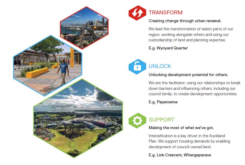
Onehunga is one of the areas Council directed Panuku to have a particularly strong focus on, alongside continuing the development of Wynyard Quarter and also transforming Manukau. Onehunga falls into the “transform” category where the goal is for Panuku to lead major urban regeneration:
Onehunga is a no-brainer when it comes to urban regeneration and significant growth. Strategically located in the southern part of the isthmus and with pretty good connections to other areas, the Unitary Plan also enables significant growth in the wider area (the area covered by Panuku’s work is outlined in red):
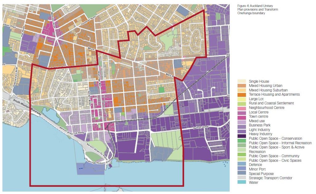
Key areas with growth potential appear to be:
- The town centre itself where development up to 27 metres (6-8 levels) is possible
- The “mixed use” zone southwest and directly east of parts of the town centre, where development up to 21 metres (5-6 levels) is possible
- Areas zoned “terraced housing and apartments” to the northeast of the town centre, where development up to 16 metres (4 levels) is possible
Further to this, there is significant industrial land – especially to the east – which I am guessing may transition over time to other uses as growth occurs and the area’s accessibility increases.
Of course the elephant in the room when it comes to Onehunga is the East West Link project. Panuku’s frustration with this project is well known and the High Level Project Plan discusses the project fairly diplomatically:
The East West Link forms part of the East West Connections programme, a joint initiative between the NZTA and AT. In January 2016, then Prime Minister John Key called it one of the government’s top priorities and a project of national significance.
The proposal’s business case says the link is targeted at delivering improvements in:
• Travel times and travel time reliability between businesses in the Onehunga-Penrose industrial area and state highways 1 and 20 (SH1 and SH20)
• Safety and accessibility for cycling and walking between Māngere Bridge, Onehunga and Sylvia Park
• Journey time reliability for buses between SH20 and Onehunga Town Centre.The East West Link is a strategic transport corridor that will connect the Western Ring Route (SH20) at Onehunga and the Southern Motorway (SH1), improving access to the rail freight hub at MetroPort and major employment areas, such as East Tāmaki. This link will address high traffic and freight movements on congested local roads; and move freight more efficiently between SH20 and SH1, and between industrial areas and the port and airport.
The link project intersects Transform Onehunga in two key areas:
• The Neilson Street interchange, including the street’s widening to four lanes and widening of the road between Gloucester Park and Onehunga Wharf from two to four lanes. The widening will intersect directly with the wharf and take about 8000sqm of land from the site. Temporary designations will cut off access to the wharf until about 2024
• The alignment across the Manukau Harbour foreshore (a four lane road) with connections back to Galway Street, Captain Springs Road, MetroPort and Hugo Johnston Drive.The East West Link is expected to create east-west improvements for public transport, and provide for walking and cycling. However, it is more about regional connections and less about local connectivity. The full benefits of the network improvements, particularly on local roads, will not be realised until after completion in 2028. Between $1.6 and $1.8 billion has been allocated for the project, which is in the advanced planning stage. On 16 December 2016 NZTA lodged the necessary documents and consent applications for the East West Link project. Their application will be considered by an independent Board of Inquiry. This process includes hearings expected to run from April to September 2017. If the proposed design is consented, construction will start in 2018.
In essence the impact of this project on plans for Onehunga are pretty massive, especially around the Port area – a major redevelopment opportunity. Also construction impacts mean that the timeframes for Panuku’s work in Onehunga will be significantly delayed. Just another mess created by this stupid project.
The crux of the Plan is in section 6 (note to Panuku – please do an executive summary for 100+ page reports!), which goes through five key strategic moves:
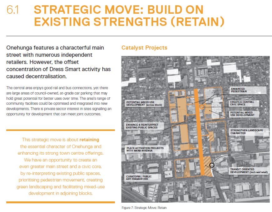
Build on existing strengths
This seems to be mainly focused around reinforcing the strong main-street character of Onehunga through public space improvements and supporting some key redevelopment opportunities. If anything this strategic move seems a bit timid but it would be great to see those carparks just off the main street be redeveloped into much needed housing.
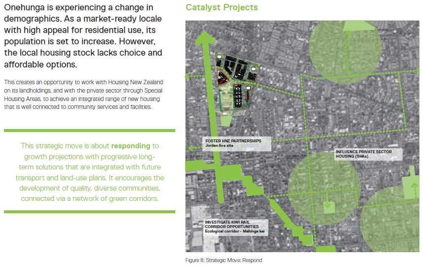
Encourage Smart Growth & Quality, Connected Communities
This strategic move seems to be focused on how Panuku can work with others, like Housing NZ and private developers, to get a bit increase in housing supply in Onehunga – but also about providing strong linkages and connections between these areas and the core town centre. Like above, if anything this move seems a bit timid given the scale of development opportunities in Onehunga, but it will be good for Panuku to play a co-ordination role in helping realise Onehunga’s growth potential:
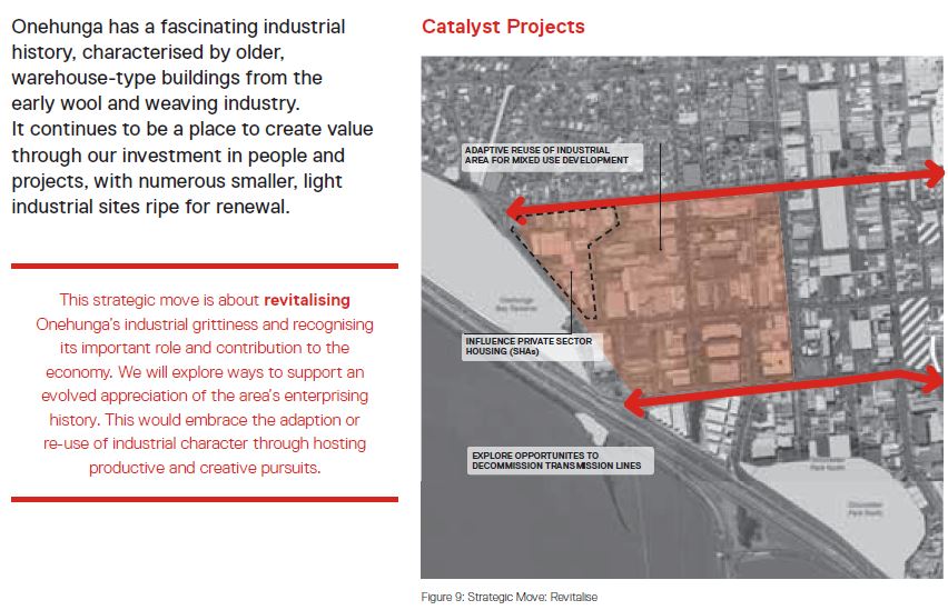
Celebrate Industrial Character & Foster Local Productivity
This strategic move, while initially seeming to fall into the common trap of proposing to retain every last little bit of current industrial use (even with massive opportunity cost), seems more about recognising the potential in Onehunga’s semi-industrial character to both give the area an identity but also the opportunity of transitioning away from industrial to both housing and creative start-up companies that may get priced out of other areas. Undergrounding the overhead power lines through Onehunga would be an absolute game-changer for the area.
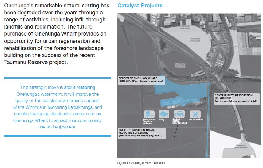
Create a Healthy, Activated, Foreshore Environment
This move is really around restoring the harbour-edge to a far less degraded state, particularly in environmental terms. It’s quite sad in many ways to see how this part of Auckland’s coast line has been neglected or actively ruined again and again over time by major infrastructure – something East West Link continues.
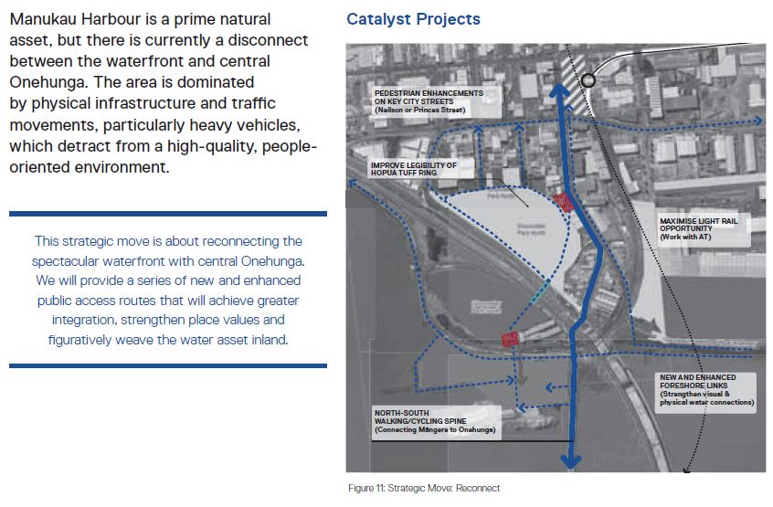
Reintegrate Onehunga with the Manukau Harbour
This strategic move is related to the previous one but really seeks to open up the linkages between Onehunga and what should be its best asset – the harbourside location. Once again, East West Link will make this task much more challenging no matter how much NZTA try to put lip-stick on that pig.
The Plan goes on to discuss particular opportunity sites in more detail – and there really are a huge number of large sites in Council ownership that are ripe for redevelopment. One of the issues though might be Auckland Transport’s reluctance to give up Park & Ride sites, if this one is anything to go by:
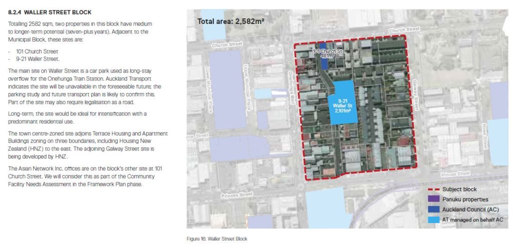
How hard is it for Auckland Transport to see how stupid Park & Rides are on this isthmus? A terraced house or apartment development basically across the road from a train station is going to generate far more trips in the long-run than a carpark.
Overall though it seems like the Onehunga plan is pretty good, although once again it highlights the massive impact East West Link will have on Onehunga and realising the potential of this part of Auckland.

 Processing...
Report highlight the tensions and trade offs inherent in the development of a city between regional and local needs.
It also highlights a major issue with the East West links founding conception as being ‘for freight’, from and to two immutable concentrations of industrial uses. In Onehunga at least, the report rightly highlight that older/smaller industrial uses/premises in particular is highly likely to be displaced.
On the flipside, the EWL in and of itself will provide a massive dis-amenity to industrial to residential conversion (not withstanding the impacts of construction on existing project timeframes – eg access to the port and loss of land for the construciton period) perhaps more than offsetting the attraction of the coastal amenity & outlook, which may actually slow or even halt the transition process.
Anything within 500m walk of the train station should be allowed to be built to the full 27m height limit to allow for higher density near this key PT route.
Personally I still think the inlet should be filled in to provide 6600ha of new land which is in a prime location for PT and central to much of Auckland. It currently isn’t used for any purpose (polluted, and not safe for water activities). The sale of the land would more than pay for the development costs and would pay for infrastructure in the area. This would be the single largest addition of land added within the Auckland urban limits in many decades (and could have enough land for the estimated shortage of houses in Auckland if built as standalone houses, if all built as medium-high density then this could house between 50,000-120,000 people in theory). However Half housing, half industrial (since we are also short on industrial land in Auckland) would make more sense and would still house 25,000-60,000 people, maybe more.
Would also connect Onehunga with Mangere. Could leave a navigable canal if they wanted for aesthetic/environmental reasons. And could build a new beach on the harbours edge so that the beach could effectively stretch from Mangere all the way through to Hillsborough.
Would also mean a bridge wouldn’t need to be built for rail across the harbour as it could be built on empty flat land.
Is there a shortage of industrial land in Auckland though? Is demand greater than supply?
Interesting idea akldude, very interesting in fact, but we would lose a beautiful harbour inlet and destroy more of our natural environment in the process. I’d sooner deal with the pollution and create waterside spaces for the growing local population to enjoy. Aren’t there cheaper and less destructive ways to house more people, such as your suggestion of increasing housing density around transport nodes?
@ David B, problem is that it really isn’t that beautiful (dirty murky water, nearby industrial on all sides (except the harbour end). The harbour itself is huge and this inlet really isn’t used. Only downside would be perhaps a loss of space for some sealife there (although could certainly rejuvenate more of the harbour to give sealife a better environment elsewhere). Cost? Sure it would cost but since it is very shallow and easy to block off it actually wouldn’t be that expensive to do (millions of tons of cleanfill out there looking for a home also).
Yes higher density elsewhere but this would be a fantastic addition. Could possibly make it a bit like the viaduct harbour with a whole waterfront precinct etc too.
It just is in such a good location for transport that would be ideal for housing and industrial. Better than sprawling Auckland ever outwards.
Isn’t reclaiming 6600 ha of land from the harbour (instead of getting to grips with higher density on existing central land) just a bit too similar to greenfields sites on the periphery? OK, not quite the same logistically, but Onehunga is where it is, and what it is, because of the harbour. Such a huge reclamation would distance it from the very water that brought it into being. Kind of disrespectful, I’d suggest.
(Although I’d always wondered about creating a village island in the Manukau, nearby Onehunga… the Venice of the Pacific. Best of all, it could one spot in Auckland with no cars. Ha, we’re all allowed dreams.)
More seriously, though, just because the Onehunga foreshore is polluted now, and bleak, doesn’t mean that it must always be like this. Once the Manukau had white sandy beaches. Think of the extremely polluted Cheonggyecheon River in Seoul, which they covered up with a road. A fairly big road, 168,000 cars/day, so similar to the Harbour Bridge I think… but then they rejuvenated the area a few decades later by removing the road and cleaning up the river to make a beautiful riverside park. So successful they removed and reduced other roads.
http://grist.org/infrastructure/2011-04-04-seoul-korea-tears-down-an-urban-highway-life-goes-on/
Let’s hope we can stop the same mistake being made with this hideous East-West Link.
+6000, approximately. Mangere inlet has an area of around 660 hectares, so the real benefits are about 1/10 of what you propose. Still, the concept is something I agree with as per earlier posts:
https://www.greaterauckland.org.nz/2016/05/31/is-a-lack-of-land-supply-the-councils-fault/#comment-210104
and here:
https://www.greaterauckland.org.nz/2016/06/20/the-main-risks-of-east/#comment-211796
Allowing 10% of the inlet as waterways leaves 600 hectares available for a bold, multi-purpose, connected development.
Yes property vacancy is at the lowest level in more than 20 years.
Has been reported that there is also a lack of industrial land in the pipeline going forward too.
Demand is currently very high but also supply is lacking.
http://auckland.scoop.co.nz/2017/04/auckland-industrial-shortage-at-record-high/
http://www.nzherald.co.nz/property/news/article.cfm?c_id=8&objectid=11186383
https://voakl.net/2016/04/06/business-land-shortage-in-auckland-unitaryplan/
Interesting, thanks for the links.
I’m seeing a few consents for industrially zoned land (light and heavy) that are changing the use to either offices or people aiming to establish residential / mixed use in these areas. Economic pressures of relatively land intensive industry being pushed further out of Auckland?
Most probably. The market knows the correct outcome, pity the planners think they know better.
Is there really anyone who thinks that Onehunga has problems that Panuku can fix or even knows how to fix? Just expect an very expensive development somewhere that has very little relevance to the market and a whole bunch of Council type twits blowing their own trumpet.
Like Wynyard?
Instead of spending 1.6 billion on a road, why not spend 800 million on building a better situated industrial area and 800 million buying up onehunga industrial and turning into appartments. Will fix multiple problems for the same price (in fact it may even be cost neutral or profitable)
The industrial stretches from edge of Onehunga commercial strip all the way through Penrose. $800 mill would buy a few blocks.
Think of who the new highway benefits, and the final answer would be the landlords who rent out the warehouse/ factory space. Good access means rising rents and property values, keep it much the same ( with limited improvements around the port/town centre) and the time sensitive industrial users move elsewhere where they can get that.
That has to be the best choice
Ya know… I’ve never thought to wonder about that idea, until now.
You’re probably on the money, the only issue being that finances are siloed, thus preventing more efficient spending.
IT has been trying to break out of silo mentality for at least a decade and business in general is now doing the same, yet our government is still stuck in 1970’s thinking in so many ways. I hope the route isn’t consented!
If they go ahead with the E-W thing they should cover over the road so it’s essentially a tunnel from the old mangere bridge by onehunga harbour rd along to the sea scout hall. Out of sight, although you would hear the rumble beneath.
Probably worth noting that the building heights you mention are “as of right” ie: permitted. Buildings can go higher than what you have listed, provided you jump through the RMA/AUP hoops.
As a local resident, I feel strongly that the East/West Link is totally hostile to the area.
NZTA have proposed a design that ticks all the boxes for Freight companies, but promises to be a complete disaster for the development of the port area, and also pays lip-service to public transport considerations.
We urgently need a re-think of the proposal – why not incorporate the LR crossing that we’ll need soon anyway, and keep the main junction as far away from the port area as possible. Or put it into covered trenches (as suggested above)?
I don’t know how it should work, but there must be a solution that doesn’t destroy the amenity of the port and coastal area.
People before trucks!!!
Surely car park land belongs to the council. If they want to reallocate the asset management to a better use why should they not be able to. Parking surveys are a total nonsense, parking is a market.
You know a proposal is fundamentally flawed when the proposal contains buzz word after buzz word.
How do the planners think all the people are going to travel? There is one train line into the area which goes in one direction. The area has little in the way of useful bus connectivity. The thing the area does have going for it is motorway access. Residents are going to predominantly travel by car in an area which already suffers from massive traffic congestion.
There is also the small matter of a speedway operating in the area. What will be the result of high density housing in an area with a speedway? If Western Springs is anything to go by it won’t be pretty.
Geographically this proposal makes sense but when you analyse it this proposal makes as much sense as opening a nudist beach in an Islamic State.
One train line, a dozen bus routes of which four are frequent trunks, a nexus of cycleways, not to mention the motorway, a compact and walkable town centre, and the fact they are planning a new rail line.
Onehunga is better connected than just about any other suburb in Auckland.