Matt’s post last month on a new apartment development in Albany caused me to start thinking about street grids. As Matt noted, the development will start filling in the big gaps between Albany’s broad, curving roads to nowhere. Here’s a picture of the development:

Albany’s got many attractive aspects. It’s got loads of space for growth, which in a growing city means that it will grow. It’s got aspirations to be a live-work-shop kind of centre, rather than just a mall in a paddock. And it’s close to the Albany Busway station – although the busway hasn’t made it far enough north yet due to some bad decisions by the Government. But that street network could easily cripple it. Albany’s curvy roads and over-sized roundabouts are good for drivers but highly inefficient for people on foot, bike, or bus.
As Jarrett Walker is fond of saying, you can’t argue with the facts of geometry. Roads that meander and don’t connect with each other will always be costly to serve with public transport and difficult for people to navigate on foot.
If sprawled-out exurbs remained on the car-dependent city fringe in perpetuity, it might be fine to build them with inefficient, non-connective street patterns. But if a century of urban expansion has taught us anything, it’s that today’s fringe suburbs will be part of tomorrow’s urban fabric. Over time, they will become more densely populated and require a greater range of transport choices. We will have to think about incorporating them into public transport networks and putting a sidewalk on every block.
Street networks are incredibly persistent. Some European cities are still laid out on right-of-ways first established by the Romans. Or think of Karangahape Road, which has been used as a thoroughfare since Auckland was first settled around 800-1000 years ago. But in recent years, some people have started to think about how we might rebuild or “retrofit” inefficient suburban street networks.
One such effort, Galiena Tachieva’s Sprawl Repair Manual, summarises a number of strategies for retrofitting suburban developments into urban places. Here’s one of her schematic designs for transforming a single-house subdivision, complete with cul-de-sacs, into a neighbourhood centre:

Unfortunately, retrofitting is costly, as it will require governments or transport agencies to buy and demolish houses in order to restore a street grid. As the overall density and efficiency of the neighbourhood would increase following such a rebuild, doing this might even make the government money in the long term. But it would involve some pretty serious up-front expenditures.
In order to quantify the “unfunded liability” associated with inefficient, car-based suburbs, I’ve gone back to Tachieva’s example and put a red X on the properties that we’d have to demolish in order to restore a sensible urban street grid that would enable better PT, walking and cycling provision.
Out of a total of around 180 properties, we’d have to buy and bowl at least 18 to retrofit a proper street grid. That’s 10% of the suburb’s houses that we would have to demolish!

In short, the costs of retrofitting inefficient suburban street networks are so high as to be prohibitive. This raises two questions.
First, what’s going to happen to Auckland’s existing sprawl suburbs? Will they hold their value if it’s not possible to provide them with better transport choices? And if we can’t, will they suffer a reversal of fortune, offering few opportunities for low-income residents cut off at the end of cul-de-sacs?
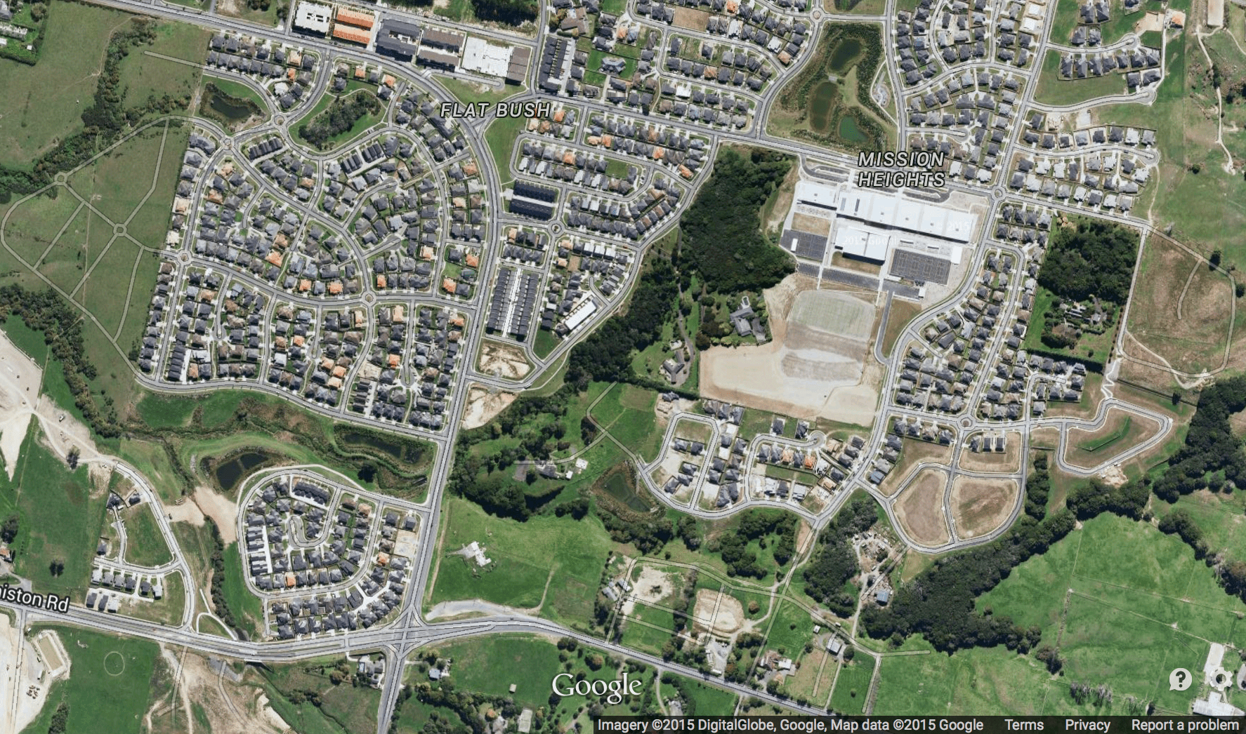
Second, why on earth are we still building subdivisions with dysfunctional street networks? What form of mad inertia is leading us to construct places like Flat Bush and Massey (below), where road geometry means that it will always be difficult to run a frequent bus route or give people direct walking access to the shops?

Traffic engineers and subdivision master-planners seem to be quite good at “future proofing” their roads for growth in demand. They build them too wide in anticipation of the day when more cars will be driving on them.
But that’s not sufficient. They need to go a step further and future proof against a change in transport demands and a change in the functioning of suburbs. The places that are being built on the edge of the city today will not work very well when they begin to merge into the urban fabric tomorrow.
Remember, you can’t argue with geometry!

 Processing...
the good thing with Albany is that it’s empty so not much to destroy. Also the present road network there is useless for cars too, with all the roads taking the longest possible way to any point, defying reality. Just start from scratch
I find Albany so confusing. To go anywhere, head in a direction that is not the direction you want to go. And don’t try walking, the roundabouts are too busy, and cycling looks scary too. Why no cycle lanes on brand new roads?
Albany is a planning disaster. Growth is the opportunity to ameliorate the worst aspects of its appalling form- will this opportunity be grasped? Through what process? The development of individual titles can only do so much, even when they are really big. The intra site link may be go, but they’ll still be stuck with that dreadful street pattern and sweeping road design, same with Stonefields. As Peter says street pattern is incredibly persistent because it sets up the reality of legal titles.
Not sure I agree with the example above. I look at that and see one good road down the middle on which to run a direct and efficient bus service within walking distance of all those homes.
Whats missing isn’t more road connections, but pedestrian connections. You don’t need to demolish houses to build paths for people. Yes you might have to demolish them for a town centre, but replacing single lot houses with dense shops and apartments should always be an economic proposition.
So I don’t see too much downside, and certainly not the need to ‘lose’ 10% of housing. Should only be a net increase in development.
Yes my neighourhood, like all tram-built Auckland suburbs, have great pedestrian shortcuts, but they were all built from the get-go. Even these can be hard to retrofit once land becomes private property.
Well said.
In the example given there is an obvious route for a bus to take and no need to demolish any housing.
This post is simply one person’s irrational hatred for a part of Auckland.
We must be due another Demographia post to try and defend the indefensible Auckland housing situation which has been directly caused by artificially restricting land supply as advocated by the know all’s on this blog.
This blog has never argued in favour of anti-density rules.
Or are you only concentrating on one side of artificially restricting land supply? The part that stops sprawl? Well then that would be distorting the market. We need both up and out restrictions gone before we know what people want.
And don’t call Phil Hayward a know it all. Ad hominem attacks are not appreciated.
It is really funny hearing Penny Hulse going on about housing costs when she chaired the committee that rubber stamped the Auckland Plan that continued the drive to squeeze Auckland and Auckland house prices.
“This post is simply one person’s irrational hatred for a part of Auckland.”
Irrational? Well I guess you’re the expert on that.
“Know all’s” (sic). I bet they know when not to use an apostrophe.
I’d like to stop and discuss with you Matty except I have a life to lead and I make it a point of principle never to engage in a battle of wits with an unarmed opponent.
Because the subdivider’s mantra always been maximum lots, minimum roads. And councils love this – maximum rates take, minimum road maintenance.
That doesn’t explain the oversized sweeping roads, it isn’t efficient land use at all. A minimal grid of narrow streets and lanes with ped and bike shortcuts almost certain to maximise gross plot area.
I know of one case of buy and bowl in Auckland (Pakuranga) – on google maps you can see that there is no longer a 36 Tiraumea Drive – it was bowled to make way for Jan Pl to connect. Agreed that Albany is a nightmare for pedestrians.
Are we looking at the same picture? I see a grid in the foreground and two curved roads above that. Both curved roads connect to something and avoid a pond. Those roads only exist to allow the land to be subdivided. Another level of connections will be needed with development.
The ninnies that designed that stoopid road pattern also plonked the pond there. Ponds are nice, streets are necessary; but this is a Masterplanning fail.
The traffic engineers’ love of the over-wide sweeping stroad is not the only partly at fault in these types of designs, it is a fashion as mofo says, and the history of the fashion for the curve and the abandonment of the rational grid is more interesting than that. Landscape architects and other Arcadians of the City Beautiful and Garden City movements saw a naturalism and sensuality in the curve, and of course the rush to abandon the ‘madding’ city also incentivised the dead-end road [cul-de-sac] precisely because it can’t be through routed.
But this design at Albany is especially useless, as noted above it’s even useless when driving, forcing overly long journeys often around in circles and maddeningly indirect and confusing drives to a collection of scattered nowheres.
High hopes for the next generation of development to make some actual there, there. With pedestrian linkages.
Genuine question: in practise, who actually sketches the roading networks in new subdivisions? Are they proposed by developers and then handed to council for their tick of approval?
It depends on the scale of development. Small subdivisions it is the developer and a tick off as you say. But in the example at the top of Albany it was a collection of planners, architects and urban designer types who did what was fashionable at the time the drew it. It is just not their current fashion. You can’t pin the curves on engineers, (you know we only draw with rulers). An engineer then looked at it and said “well there is nobody there so we wont put in signals until they are needed. You can have roundabouts in the meantime”
Albany structure plan was designed in the early nineties by Hames Sharley Ltd. They had a local office but most of the design was done in their Adelaide office and forwarded overnight by the newly invented fax machine. And, if only traffic engineers did use rulers, Mfwic ! I look forward to you supporting orthogonal vehicle crossings, slip lanes, kerb corners, median islands, roadmarkings …. Right angles instead of transition curves would send a strong psychological message to drivers !
Hi John I heard the whole Albany thing started as a rear guard action by the Takapuna business men who controlled the Takapuna City Council (well prior to NSCC). Their intention was to prevent a major centre near the Northcote interchange that might compete with their shops and instead push it up to Albany where they thought no one in their right mind would actually build it. As for rulers, I do have a few railway curves in my draw (I quit freehanding because CAD people whinge too much about sketches without fixed radii). But if any engineer ever tells you a city street needs a transition curve just laugh at them. There are a few traffic islands around that I regularly drive over that may as well have square corners! We could do them everywhere so long as people are ok with trucks using both sides of the road.
Deadend road has less traffic from non residence. That means less noise and preceived safety for children and less strangers around.
That will make the house price higher.
Thats why developers like to build the road like this to maximize section value.
Correct. Cul de sacs are seen as kid friendly and pedestrian links are perceived to increase stranger danger.
We’re building subdivisions with dysfunctional street networks because people want them and developers are happy to provide because, as mentioned above, more developable space. Homes on cul de sacs sell at a premium. Kids can play in the street, very little and only local traffic, quiet, etc.
(I know it was a rhetorical question. Why indeed.)
We can turn any street network into a series of cul de sacs. It doesn’t need to resemble a cloverleaf. It’s called filtered permeability. It allows people walking, riding bikes or using their mobility scooters to access the entire network while keeping the peace of mind that a traditional cul de sac offers, without the negative impacts of removing a walkable neighbourhood..
Exactly – a cul de sac for cars only. That makes walking and cycling much more attractive options.
https://bicycledutch.wordpress.com/2013/08/08/making-a-1960s-street-grid-fit-for-the-21st-century/
London has quite a number of these (used to live right next to one in Arsenal). They stop through traffic of the car variety but allow bicycle and pedestrian access. And to be really clever, you can make them accessible to emergency vehicles.
Like this: https://goo.gl/maps/r7ako
There are heaps of these in Melbourne. They are so annoying if you live near those things and you drive. From what I believe, Melbourne created these (and narrowed arterial roads too) in order to force traffic to use Citylink, which is a tolled highway. The tolls are absolutely ridiculous. Costs about $8.50au to use about 5km of it. You kinda have to use Citylink if you are driving unless you want to spend ages being stuck in traffic on a two lane arterial road
You can’t argue with geometry – but you can be diametrically opposed!
Occasional Albany shopper comment: If you park in the Mall car park area to visit the Mall ’tis ok but then need to go to Briscoe’s or Dick Smith it is safer to get back in the car and drive in a roundabout way to their nearby parking area.
We tried walking across once to find we were taking big personal risks from circling drivers. And no direct pedestrian path.
In my view the whole design is a total fail. We avoid the place as much as possible but lots seem to like it or they wouldn’t go there.
All shopping centres will need to be designed like this under the PAUP. They are changing to maximum parking rates so the neighbour will be able to build a shop with no parking and let his/her customers bludge of yours. The design response will be to make walking next door as difficult as humanly possible. Forget roundabouts we will be building the Berlin wall around shops with parking.
Sounds like failure ‘compounded’!
The 277 mall in Newmarket also figured that out. No need for big walls though. If you park in their car park but don’t purchase anything in the mall you just have to pay extra.
Well more traffic on the motorway and bridge, the bridge might just collapse one day with all the extra traffic – THIS DEFINATLY CALLS FOR ANOTHER HARBOUR CROSSING – HA! HA! – I DONT THINK THEY CAN SEE PAST THE CITY AND FORGET OUR NSHORE SIDE OF AUCKLAND. TELL THEM TO GET THEIR ACT TOGETHER, IT IS ALL ABOUT TRAINS, TRAINS, ETC.
Um does that make any sense?
No but it sure is shouty.
Its a shame old albany village is being forgotten -i’d rather live in an apartment next to the village and the green spaces there, than surrounded by carparks and roundabouts – I can’t beleive anyone would want to live in Albany Mega Centre?! (but then, the St Lukes Mall apartments are popular with people who love visiting the mall…yikes).
One thing I HATE about albany/north shore are the restaurants/pubs in a strip mall. I cant believe people visit those places. Especially when they try so hard to create a english/mexican/etc themed interior. Do people go into zombie mode the minute they leave the safety of indoors then stay oblivious to the fact they’re surrounded by sprawling crap as they drive around?
Hmm….I’d love to see a post on “the glorious strip malls of auckland.”
Albany Village is dying a slow death due to lack of parking. The local paper ran a story on it last week.
The artificial design of the Albany Mega Centre and environs set the old Albany Village up to die a slow death – it is one of about five or six mini shopping areas separated by unavoidable short car rides and they won’t all survive as such. The village’s best option is change its focus over time to residential. It has lovely parkland nearby which would help.
Yeah, that’s one of those stories that is run on some regular basis. To figure out why, go on Google Maps and figure out how to walk from one of the surrounding residential streets to the village. Often the walk is too long because of the detours, even if in a straight line you’re only a few 100m from the town centre.
Footpath. Path.
What about a post on the unfunded liabilities of intensification. Like the $10million payout to the Spencer on Byron people who payed for an apartment in a building that leaked.
That’s the unfunded liabilities of having Maurice Williamson as a minister, or any other muppet that thinks the world is a better place without regulations. Un-intense buildings frrm that period leaked too.
Nothing in comparison to the payouts on leaky houses!
We new to get the planners into their shoes so they can design the upgrades now for the pedestrian access to all parts of this area. It would be best if it could be arranged that they do this footwork on cold, wet, wintry days.
They need to do the same exercise at the Work town centre now, before the bus delivery point is moved to the rail station area.
Wiri town centre
A lot of street layouts like Albany look to have been set out from what someone thought would look good on a plan – wavy pointless sort of streets. And weird places like Flatbush which have quite high density in the middle of nowhere – as if land is in short supply when clear its empty for miles around. And the density is of a useless kind – not like say a rural village in England or Europe.
But that’s not to say greenfields development is not the way to go for Auckland – as it obviously is. It provides the opportunity to get PT and walking/cycling optimised from day one in the street layout – as well as parks etc. As you point out retrofitting existing suburbs as per compact city/smart growth/Unitary Plan ideals is far too expensive and inefficient.
Also that was a good point about the ‘sprawl suburbs” not “holding their value” if they don’t get “better transport choices”. Isn’t that exactly what we need for the less well off? A good source of affordable housing?