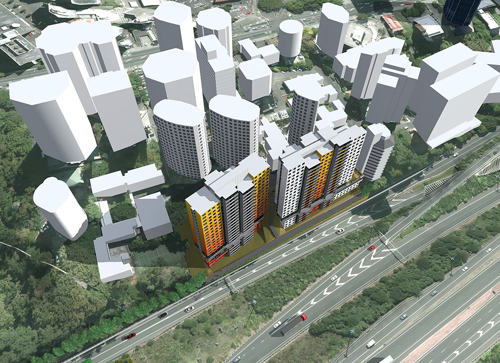
Auckland Transport yesterday started the second stage of the Beach Rd cycleway which when finished should finally help to make the first stage as well as the Grafton Gully cycleway useful.

The Beach Road walking and cycling project begins its second and final stage on 30 March, continuing the transformation of a key link into the city centre.
Auckland Council and Auckland Transport (AT) are making it safer, easier and more enjoyable to walk and cycle on Beach Road, upgrading the northern side of Beach Road, between Mahuhu Crescent and Britomart Place.
Part of Auckland Council’s City Centre Masterplan (2012) this jointly funded project will transform the look and feel of the street through use of high quality paving, feature lighting and planting of native coastal species an echo of the area’s rich cultural past as well as a reference to Auckland’s original foreshore.
The works will extend stage one of the Beach Road cycleway, successfully completed in September 2014, connecting to the pedestrian laneway network in Fort Street and with the shared walking and cycling path on Quay Street. The route will be a mix of separated cycleway and sections of shared path around intersections, with paving designs and cycle symbols helping to separate pedestrians from cyclists.
Auckland Transport’s Walking and Cycling Manager, Kathryn King, says: “By linking with the Grafton Gully and north-western cycleways, the completed Beach Road cycleway creates a continuous, safe and convenient route for people to access the city centre by bike.”
Ludo Campbell-Reid, General Manager of Auckland Council’s Auckland Design Office, says this project is one of a range of cycle route projects that are making Auckland city centre a far more attractive place in which to walk and cycle.
“We are creating city spaces in which people want to spend time shopping, dining and relaxing.” he says.
“Beach Road’s upgrade includes innovative features such as small pocket parks and information plaques, and special stormwater rain gardens located at the junction of Beach Road and Tangihua Street to help filter out pollutants in the stormwater before it flows to the sea.
“Coastal plants will reflect the location’s history as a beach and the large attractive London Plane trees will be uplit at night as a stunning feature.”
Of the $3.5 million project cost, $1.5 million is funded through the City Centre Targeted Rate, a special rate that all city businesses pay to fund improvements to streets, parks and plazas. This is administered by the Auckland City Centre Advisory Board, which is made up of community and business representatives.
“Innovative, smart and progressive cities around the world are finding that having safely designed and well-connected cycle routes passing through their areas brings great economic benefits to businesses as well as demonstrable health benefits to the cyclists” Mr Campbell-Reid says.
The upgrade aims to:
- encourage an increase in walking and cycling within the area.
- increase safety and the perception of safety for people walking and cycling.
- expand the Auckland Cycle Network and provide connected, continuous routes.
- incorporate place making into the design.
- create an attractive and distinctive street and public space.
- Works completion is expected by early July.
Power infrastructure company Vector will undertake works within the same area, to future-proof underground cabling so that the footpath does not require digging up again at a later date.

I’m looking forward to having this part finished along with hopefully soon the other city centre priority projects.


 Processing...
All great. Questions remaining:
* The obvious pinch point at the north end – will the planter be reduced or that vent be somehow made less in the way? it looks like it’s being left as is which is pretty disappointing (http://goo.gl/YALFZU)
* Any plans for Tangihua street to countdown/Quay Street? If not, when?
* What exactly is happening at Britomart place – does it connect into Quay Street or the quiet Britomart streets?
* How is the fort street intersection handled, exactly?
Really excited that this eye sore is finally getting some love, with cycle lanes to boot – a real no brainer. just hope the fine details don’t leave too many issues, or forget that people are cycling locally, not just coming into downtown from the northwestern….
The space around the planter is widened each side to some 3m.
Nothing on Tangihua itself. Tho the cycleway will now have two links to Quay Street – via Britomart Place (a short new shared path) and at Mahuhu Cres/Tapora.
Nothing will change immediately directly west of Britomart Place – too much stuff will need to shuffle around re buses and so on due to CRL works over next years shifting stuff around. However, there will be a new signalised crossing to Fort Street, so easier to continue west along that line at least.
The pinch point will not be as bad as it is now, David – the planters will be pushed back to make a wider shared space around the circular vent. On the other hand, the planter will be pushed much further towards Beach Rd, making a very indirect route from the footpath beside Scene 1 to the takeoff point of the pedestrian crossing. Why not take the shared path closer to the desire line and split the large planter into a smaller one round the tree and a larger one to the south, which could become continuous with the one along the kerbside ?
Also, the kerbside planter should have a paved break where people cross on the east side of the Anzac Ave intersection.
I think the answer to where cyclists go next is that we have good options – left into Fort, right into Quay, straight ahead into the one-way Galway….
I’m pretty sure space to the right and left (between red lines) can be cleared. Hopefully, anyway – I don’t want people on foot hating cyclists – already enough of that…
http://i.imgur.com/Dc1pR5C.png
Blue line indicates where the new kerb will be. Right? 🙂
See the plan screenshot I put on Twitter
https://twitter.com/MaxRobitzsch/status/582788777837379584
So I see a widened footpath and a ramp onto the existing road….How does that work allow AT to once against draw another street as being ‘completed’ in terms of cycling when literally nothing is being done to the street itself?
I’m very happy to see yet another slip lane removed, that’s been one of the major benefits of this project for pedestrians, the removal of almost all slip lanes along Beach Rd’s length.
Yeah, Grafton Gully / Beach Road in total will then have then done away with 6 slip lanes, signalised 2 more, added raised tables to 2 more yet and closed one side road.
Hmm thanks! It still *looks* narrow, but trying to adjust my brain scale it looks comparable to a car lane which should be plenty! Is the whole corner a ramp or just the two bits lining up with the ped crossing? Good to see a ramp on the other side, but my biggest concern is that nothing here looks with an eye forward to connecting it to britomart – I’d rather have squished everything upwards in that photo to make space for a lane on the bottom (going right to left) giving access to britomart along Galway and the atrium. Is britomart place to be a shared space eventually? Would solve a lot of issues here. All of britomart being shared (or bike/ped only) would help….
Hopefully the phasing will be much longer also, as the crossing is now an extra 3-4 meters with the island gone.
Got
To BBC – AT’s walking and cycling department is under new management. I am currently working with them on a project of re-looking at what had previously been considered completed, to identify issues. With the small budgets and the stiff resistance cycling still faces in some corners, it won’t get all brought up to modern standards any time soon, but I think you can rest a bit easier that AT walking & cycling department is thinking more in terms of progressive improvements, rather than box ticking now. I may be strongly biased, but I have worked with the new walking & cycling manager, and she’s good value.
To David – as I noted, there’s a bit of a reluctance to do anything in Britomart proper, as a lot of buses will need to move out of the area around the Precinct skyscraper construction site and from QEII square while the CRL and the skyscraper are built. For a while, they were even wondering whether they could do anything in Britomart Place (i.e. in the area of my screenshot), as lots of buses could potentially be rerouted here (they may still be, not sure).
Re the signal – yes, when a crossing gets redesigned like that (with a new crossing on teh east side, slip lanes removed etc…) then the signal times for pedestrians would also be looked at. So should hopefully be okay.
David, if by “whole corner”, you mean the lower right of the image, no there’s only the two dropped kerbs at the crosswalks – guidelines discourage dropping the whole area as this means vehicles can track over the pedestrian area too easily, and vision-impaired-people can get confused where the crossings are. There is one added road->off-road path ramp just a bit up from the signals in the image. CAA has asked for that to be moved further south so you can go onto the off-road path earlier, will see whether that happens. There’s also a ramp leading to the lower left, into/from the Britomart Place space, and of course the shared path leading west to the Quay Street walk/cycle crossing.
Max – thanks!
I was just interested in connecting the two ramps together to give more width for cylists – less contention with pedestrians. I hadn’t noticed the ramp at the south – I’d probably end up using that both ways then.
Overall – as you highlight – all the slip lanes being gone is a god send (I walked from mahuhu to downtown every day for years) – even without anything else that would be a big improvement. I’m just nitpicking now because I’m greedy for more 🙂
Regarding the buses – it’s awkward for sure – closing it off was a longer term aspiration making the need for separate cycle lanes through there redundant 🙂 As long as they don’t have them going down fort street again, anyway.
I notice that they are adding in a extra ped crossing at the across Beach Rd at the eastern side of the Britomart, Customs, Fort, Emily intersection? Yet they don’t they allow for Barnes Dance movement. The current phasing has a all ped phase already.
Yes it does but it’s currently poorly signalled and unclear for anyone not familiar with the intersection.
Symonds st Symonds st. A main arterial for people who cycle to Uni and the City from Great North and Mt Eden Road. Its like they’re ignoring the most obvious desire line…..
-bus sewer.
This is the best bit of the whole sordid project, and it’s important to remember why: it attaches to actual frontage on streets that people want to stop or start trips at, and it connects to various side streets (thereby multiplying reach within a distance constraint). It’s also worth noting that these benefits do not rely on the “scaffolding” of the Northwestern route or Grafton Gully; it would have been justifiable to build on its own — as eligible as are a number of other streets around it, which are sadly neglected in the priority map.
In fact, it’s particularly galling to see Symonds St left out to dry, given it would fit perfectly with the K’Rd and Ponsonby Rd ridgeline theme, and extend service to Newton, Eden Terrace and the Learning Quarter proper (instead of glancing by at the bottom of a gully). The grade profile of Symonds St and Anzac Ave is still much gentler than the gully way and deserves to be protected for non-motorised travel too.
I’d also hesitate to say Grafton Bridge is “completed” in any sense; it’s an ongoing problem, unfolding in slow motion. Something will need to be done about bus vs. cycle conflicts there sooner or later.
Given the space constraints, how would you deal with Grafton bridge. Only way to create more space would be to tack on clip ons but that would likely damage the look o the bridge.
Grafton Bridge is ‘okay’ at present, it’s certainly not relaxing having buses overtake and bearing down on your from behind, I’d agree it’s unwinding since taxis will soon be allowed on it and will for sure not only make it unpleasant to cycle but will slow down the large numbers of buses that use the bridge. It’s such a bizarre decision IMO, surely it’s going against the requirement of it being bus only that allow the central connector to receive funding during construction?
The only solution I could see would be to make one side pedestrian only and one side bike only, far from optimal considering the number of pedestrians that walking across. Not allowing taxis back on would be another good move.
Matt,
I don’t know enough (especially about future PT plans) to offer a comprehensive solution to Grafton Bridge. I imagine it won’t be simple or easy, when it does become a high-priority issue. All I can say is the current situation isn’t at all satisfactory, and it will only get worse if nothing is done.
Here are some thoughts on current problems and low level fixes:
* It’s great that car traffic is limited; this is the only redeeming feature currently. A 24hr exclusion and reversing the taxi trial, will help. It will especially solve the problem of careless drivers blocking the turning arc of buses on the west end intersection, which is unavoidably poorly designed.
* Bus vs cycle moving conflicts are quite bad already. A casual observer will witness buses breaching the posted speed limit, crossing double yellow lines to overtake bikes. I can’t see a quick fix for this that won’t unfairly impact bus users — e.g. enforcing a slow speed limit.
* Stationary conflicts between bus and bikes also happen, especially at the intersections. At the west end, bikes are routinely caught behind diesel bus exhausts (can be solved with electrics), but are also sandwiched in ambiguous or intimidating positions such as when turning right (can’t be solved without separation). At the east end, the right turn lane is particularly tricky, but so is the advanced-stop-box leapfrog game going straight on to Park Rd, but I imagine an intersection overhaul with bike tracks on adjoining streets would help.
* Pedestrians don’t have it easy: it’s cramped, crowded, poorly sheltered; vehicles splash water; the noise and fumes suck; and people increasingly spill into the carriageway for good reason. This rules out closing off one side of the footpath to reallocate space, or making shared paths.
Higher level fixes have pros and cons:
* If buses or bikes are to be separated, which one should stay on Grafton Bridge? There’s an argument for keeping bikes as the gradient and integration with the ridgeline is optimal.
* If buses stay on Grafton Bridge, could there be a feasible second crossing for pedestrians and cyclists? I can’t see how or where, but maybe it can be done. I imagine it would be cheaper to build a cycling bridge than a bus bridge if a second crossing is considered.
* Could buses routes follow a different alignment? I’ve modelled a few scenarios such as using Grafton Rd (like the 283) between Park Rd and Symonds St. This has some merit, as buses are better able to cope with grades, road design and land use along there. The disconnection of a few stops isn’t so bad for most routes (non-peak, non-express, non-Link — those could go via Khyber Pass), especially if Grafton Bridge becomes a walking and cycling haven. But all this depends on new network assumptions that I’m not privy to.
* A more exotic idea is to make Grafton Bridge one-way for buses, but I’m not a fan of splitting a line.
* An even more exotic idea is to expand the Bridge somehow — clip-ons, parallel structures? — but I’d agree that’s a non-starter.
Have you considered anything like this, with regard to bus routing especially?
All I’m saying is Grafton Bridge isn’t “completed” for cycling in any sense — it’s problematic, though not easy to fix. However, solutions are within the realm of plausibility, and will only become more necessary over time. AT shouldn’t brush it aside in their planning.
More useless cycleway. A nice get cyclist onto the pavement and off the road solution that means cyclist become second class road users at all the major intersections. Quite why this is on the north side of the road I don’t know (well, I do, its so people can park there cars!). When coming into town I want to be able to ride into town. Not next to town before being spat out into traffic. I would rather stay in traffic in the first place.
Have any of these designers ridden a bike other than to cruse up and down the waterfront?
The more we advocate routes like this the more grief we will get from drivers for not using it. They simply don’t understand that these are not fit for purpose. Other than promenading.
I’m with you. The more I see of this the less impressed I become. I’m not looking forward to the mix of peds and bikes at Britomart place; it’s bad enough trying to cross the road on foot from Beach rd into the station, given the total stuff-up that the road layout / crossing already is.
I’ve bleated enough here about the failings of this second entrance to our biggest transport interchange, and this is only making it worse.
Further thoughts:
* Greys ave is screaming out to be the connector here – through aotea square, onto rutland and you’re connected to the wellersly street bit
* With the above, and If/when high street and lorne street become shared spaces (just do it already!) we’ll have another north-south route. A north south route that will actually be useful in delivering people to places they may actually want to go TO, instead of just passed…
This looks a lot more useful, and I can’t see how it’s making traffic any worse: http://i.imgur.com/MwWqUs1.jpg
/Edit: missed a spot
I can’t help myself…. http://i.imgur.com/NS0FHPR.jpg
Ponsonby to parnell via krd and the domain?
I don’t think much of this is too hard. Trying match routes to hills and places worth being at.
“duh” nice.
Just a slight grizzle here… the last two mornings I’ve had vehicles parked in Beach Road “dirveways” with the rears protruding into the cycle lane. Not much point having a cycle lane if you have to divert onto the road every day.
I guess the only solution is get off my bike, take out my phone and snap a picture of the licence plate, and then complain to AT?
If the end of your bars is metal then don’t go to the effort of taking a photo
Looking at the map above shows a big gap exactly where tens of thousands of people go every day: straight down Queen St.
So unnecessary to keep for cars. So easy to give priority to peds, bikes, buses and LRT.
Very steep at southern end – and future layout also now totally up in the air re new plans for light rail.
I’d suggest it’s quite simple: If LRT is provided, then remove vehicle access from Queen Street altogether. Plenty of space for bicycles!
Heck, even before LRT, we can do PT-only, car-free Queen St, and reclaim enough space for bikes.
“…an echo of the area’s rich cultural past as well as a reference to Auckland’s original foreshore.”
Will there be a physical reference line to show where the old foreshore was, like a Rose line?
Also, I’ve been on the Grafton Gully cycleway a few times and find it difficult at the top end to actually get on it. The image above makes it look like you can get on the cycleway from Grafton Bridge or Symonds Street, but I couldn’t find how to do that? I ended up going all the way to the start at Upper Queen St, when there could easily be an entrance from near Symonds St via the cemetery.
There’s only one entrance – the one you found on Upper Queen St.
A Symonds St entry was wanted from the start, but fears from the heritage people about people (well, cyclists!) going through the cemetery ensured it didn’t happen (yet).
Some Councillors got a bit antsy, even though heritage advisors HAD been involved from the very early start. And of course we also have Brian Rudman (“Bikes are an outdated mode of transport”) who gave us this gem of slanted opinion:
http://www.nzherald.co.nz/opinion/news/article.cfm?c_id=466&objectid=10832260
Isn’t it Ironic – what the cemetery badly needs is the presence of some warm souls. A cycle-way would be perfect activation …
+1
Stu,
May I respectfully suggest that there are higher priorities for people wanting to use bikes than going around activating cemeteries. Let’s activate streets, shops, and living-people places first.
Max,
The problem is in the word “entry” — it’s already a degree of indirection, alienating the street from the bike path. Just imagine: bike-enabling Symonds Street will yield a thousand “entries” to a new and better path.
There is a pretty simple and cheap fix, that wouldn’t be ruining many graves, if any. It even links directly to the shared path on Symonds Street where cyclists would be, and doesn’t affect the motorway onramp. http://i.imgur.com/EpaPdnX.jpg
P.S. Google maps doesn’t show the new cycleway yet but you get the idea…
That bit of the cemetery is far too steep; it’s like a cliff where you have drawn your red lines. But a pathway could probably take a wider loop close to there and then split into the two directions down the bottom where the fence and planting for the cycle way is now.
Rudnam said ‘No doubt from a traffic engineer’s viewpoint, a green space full of dead bodies could be seen as “underutilised”.’
Well from this traffic engineers point of view yup!
There is a second new entrance that opened this summer – Whittaker Place, providing access to the Uni associated buildings here. Plus at Grafton Road you cross at lights that enable you to get up to Symonds street too.
This new development seems like it will also provide another connection to Whittaker Place further south than the existing one.
http://www.southside.co.nz/35-whitaker-1
The #1 problem with this walkway at present is lack of shelter from the rain. It’s a street path at the base of buildings, so should have an awning out from the buildings. Presently you see people dashing along this section in the rain, or trying to huddle against the buildings hoping for some shelter.
The new plan doesn’t appear to fix this, despite it being the #1 concern of users.
I’m a frequent user and it’s no concern of mine about no awnings and I doubt it’s anywhere near anyone’s no# 1 concern. My main concern is the revolting street frontage of the buildings, but in terms of what council can do the fact that it’s a vast mess of a pavement that just gets used for carparking and loading vans. This will nicely stop that for starters, as well as improving the general appeal of the area and continue the cycleway obviously. In fact one of the major positives is the removal of the awful slip lanes on Tangihua Street, I’d say that they are on the top of all users’ lists as they dangerous and have no place in a downtown environment.
I just wonder if all the port traffic will be able to track around that corner. They will definitely be going through there a lot slower, causing delays for buses and what not. My guess is that pedestrian delay will double because of the removal of the slip lanes at Tangihua. Safer yes, more efficient, no. At that intersection because of demand of PT and Freight, pedestrians will remain at the bottom of the heap.
Don’t understand at all what you’re trying to say here? Almost all traffic turning left here is from my experience SOVs driving at hight speed, making it a dash for life getting to the traffic island where you then have to wait for a cross signal and then dash again through cars and trucks barrelling through the slip lane. This change will remove both slip lanes and replace it with a single pedestrian crossing, so there shouldn’t be any additional delays. The whole issue of trucks however is an important one in that they should have been banned from here years ago. What was the purpose of the Grafton Gully Motorway if trucks still rumble around the central city posing a hazard and destroying the roading as they go.
Will the footpaths on the northern side of Beach Rd be improved.