With the massive tunnel boring machine nearly here, I thought I would go and check out progress on the project. The last images we saw from the project were aerial photos which helped to show the scale of the project. Unfortunately I don’t have the budget to hire out a helicopter so you will have to make do with photos from ground level.
First up I visited the new Richardson Rd bridge which will cross the motorway. The image below is looking south-east towards Maioro St where SH20 currently ends.

Here is from the other side of the road looking north-west.

Off Methuen Rd there is a lookout over the works around the Southern tunnel portal area (it is the green patch just to the left of the leftmost crane in the image above). The next image is from there looking east. The Richardson Rd bridge can just be made out in the distance. You can also see where the trench starts to descend into the ground.

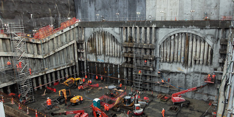
And lastly the tunnel portal itself.

To give an indication about how deep the portal is, The parts in this image below from the Herald aren’t even visible in the image above.
Unfortunately there wasn’t really anywhere I could easily stop for a photo of the progress at the Northern portal end. Waterview is such a massive project and even though it is a road, it is one that I do support being completed. My biggest gripe so far is that unlike the Maioro St interchange, it appears that the NZTA, most likely in consultation with Kiwirail have gone and repeated what happened at Dominion Rd by not building and extra span under the road to allow for a future rail line. I’m almost certain the space has been left for it to happen in the future but it just means that there is one more hurdle to address before we might be able to get a rail branch line to Mt Roskill.
For the record, this is the response I received from the NZTA on why Dominion Rd is in the same situation.
The answer to your question is that at the time, a conscious decision was made to not spend additional money time given the long term nature of any rail development. This decision was made in conjunction with KiwiRail as were other decisions around the extent of future proofing along the SH20 corridor.

 Processing...
You say that nothing of what we can see in the image from the Herald is visible from the public viewing platform – there is a tiny degree of overlap – the top half of the fair face vertical panels seen at the top of the Herald image are clearly visible in your previous photo as viewed from outside the trench. Most of the darker (oxide tinted) ones at the left (above the northbound tunnel mouth) will remain visible when the project is completed but the lighter coloured ones (plain concrete) will be hidden by the large fan room which will sit above the mouth of the southbound tunnel.
As to you concern about future-proofing for rail: the recently opened Richardson Road bridge and the Maioro Street interchange both have an extra span to accomodate the future rail lines. There is a full rail designation from Onehunga to the existing rail line just west of New North Road – KiwiRail and its predecessor OnTrack willingly allowed NZTA/Transit NZ to take over part of the original rail designation for their SH20 projects – but only in exchange for a replacement designation which allows the future railway lines to run just north of and parallel to the motorway, rather than having to cross over the motorway alignment twice (technically challenging and expensive).
Graeme – yes I’m aware of the corridor but it doesn’t appear that the extra span at Richardson Rd has been built. Take a look at this image from the NZTA back in April. The extra span should be to the right of the bridge but it doesn’t appear to have been built. As I said I suspect it has been designed to accommodate it but that the work build it has actually been taken out of the project to save money. Kiwirail also did this with a lot of the bridge rebuilds they did down south for electrification, designed them for a third track but didn’t actually dig out and build the extra span.

unrelated to this article, but another wonderful opinion in the herald:
http://www.nzherald.co.nz/motoring/news/article.cfm?c_id=9&objectid=10894929
i’m pondering a response to him, but I definitely think that the answer to his query about car of the year should be a bus (Northern Express double decker?) or a bicycle (he hates those as well)
Living in the area, I can’t support this polluting obscenity, which can only encourage more single occupancy vehicles on the road. Moreover, I note that the same indefensible cost-cutting that’s occurred at Richardson Road also seems to have happened at the point where a future Avondale-Southdown line is planned to cross New North Road. Given the nature of the local geology (ie volcanic basalt) it will pretty much be impossible to make a grade separated connection at this point without wildly expensive engineering works; a situation exacerbated by the proximity of the road tunnel. The fact there’s a surface designation along the northern side of the tunnel is, under the circumstances, almost irrelevant. KiwiRail, in effect, seems to have displayed its usual inability to think beyond the annual budget; yet another example of why KiwiRail’s responsibility for rail infrastructure should be transferred elsewhere.
That and the addition of big box retail on Stoddard Rd has pretty much condemned the area to being a massive traffic sewer. The eye-wateringly ugly building which sits in a depression on the corner of Stoddard and Maioro St. extension punctuates the area in characteristic style.
However the location of the future Owairaka station, at the point of the Richardson Rd over-bridge Matt mentions above is spared the vast auto-domination of the Maioro Rd over-bridge and will be able to develop into something of a more human scaled community service centre, especially once that rail line is in and operating. At least the big box is on the traffic sewer already.
All I see (even when complete) is a hideous scar on the face of Auckland and it is nothing to celebrate, rather its just another motorway destroying vast kilometres of land. The way it cut the foot off Mt Roskill in the first phase is appalling.
Is the rail connection mentioned here actually for real and has a completion date or is it some fantasy sometime maybe in the next 100 years?
The rail connection is on the Auckland Plan, however I doubt the full link will get built any time soon if at all. Nontheless, the part of the corridor between Mt Roskill and the Western Line does make a lot of sense and is a lot cheaper to finish than the the other side. I wouldn’t be surprised if that happens sooner rather than later.