The group pushing for an overhead version of the CRL have cropped up again. Yesterday they published a letter and presentation that they have sent to both Len Brown and Gerry Brownlee and a few others with their alternative. They are now calling their proposal eLtrack.
eLtrack – an elevated alternative for the CRL Tunnel.
We are a group of Auckland-based infrastructure consultants. Over the last year we have prepared a contemporary and affordable alternative for the proposed CRL Tunnel.
Our proposal, which we’ve called eLtrack, is a mostly elevated train route above existing transport routes. It provides a range of benefits for the city when compared to the tunnel proposal, not least of which is a significantly lower cost.
The eLtrack route is double-tracked and meets the specifications for the new EMUs. We have completed an assessment for the route and taken account of relevant transport, engineering, urban design, and planning matters. An ‘order of magnitude’ cost estimate is also available.
The project is explained in the attached brochure. The Light Rail Transit component along Queen Street and Karangahape Road is essential to the idea, and is included in the estimated cost.
eLtrack was presented to the Office of the Mayor, NZTA senior staff and senior personnel of the CRL team early last year, and was mentioned in the City Centre Future Access Study (November 2012). We are disappointed that it was not seriously considered in that report, and we believe its casual dismissal as a viable option was a mistake.
The advantages of eLtrack over the tunnel, additional to its savings of around $750M, are outlined in the brochure.
We have met with the MP for Auckland Central, Nikki Kaye who suggested we write to you with copies to key decision makers. We consider eLtrack needs a serious evaluation as an alternative to the tunnel. We recognise the extent of work that has already been done on the latter, and that an evaluation may still favour that option.
The group fully supports the concept of a City Rail Link, and does not seek to slow progress toward that end. However, given the scale of the project and the Government’s reluctance to contribute to its cost, we consider it prudent to have a viable and lower cost alternative for all parties to consider and compare.
We are prepared to meet with an evaluation team and table the information we have prepared. This includes track alignment diagrams, sketch cross-sections and the cost estimate.
We would appreciate the opportunity to present eLtrack to you personally, and to arrange a meeting with your evaluation team.
We have looked at this before here and here but it is probably worth addressing it once again as there is quite a bit wrong with this proposal. Here is what they are suggesting.

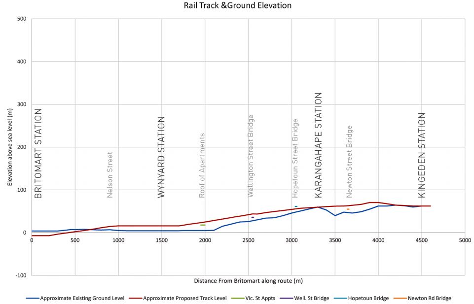
I don’t think that the image quite shows just how much impact they are proposing. The very reason the NZTA ended up building the Victoria Park Tunnel was because the local residents strongly fought to prevent another viaduct being built. Perhaps by proposing an even higher viaduct they think they the residents will be so shocked it would give them all coronary and therefore they won’t fight the proposal. In reality the visual impact is likely to be immense. From what I can tell, it appears the track would be approximately 10-15m above Fanshawe St, 10m above the Wellington St bridge and 10-15m above the Newton Rd bridge. As a comparison the Newmarket viaduct is up around 20m high.
But the visual impact isn’t the only issue with this proposal. By far the biggest issue is simply the catchment. The CRL travels right through the heart of the densest area of employment in the entire country. There are something like 80,000 jobs and 60,000 students within range of the CRL stations yet the focus of this proposal seems to be on getting a station at Wynyard, an area that is predicted to have somewhere in the range of 10,000-20,000 jobs. Why you would try and avoid the area that would provide the most benefit is a mystery. Here is a map showing a 400m walking catchment of the CRL stations (red) verses this proposal (blue).

Wynyard will also eventually be connected with a rail station when a line to the North Shore is built further diminishing this proposal compared to what is being planned.
Other issues include that the route is roughly 700m (20%) longer than that taken by the CRL, reducing the amount of benefit we would receive from faster journeys. They suggest that at $2.14 billion their proposal is $700m cheaper than the CRL however that seems to be comparing their propsal to the inflation adjusted price for the CRL. The actual price for the CRL is now down around $1.8b and could drop further as the project progresses. In a bid to save even more money they suggest building the eLtrack as only a single line initially. For some reason the proponents also seem to want to prevent any buses from actually getting into the CBD and have indicated that all bus routes will terminate at the outskirts of the CBD and transfer to either the rail network or an at grade, tram line that runs from K Rd to Britomart.
All up the scheme seems to fail on almost every single level, it doesn’t save any money, it doesn’t save any time, it doesn’t go where most people want to go forcing a lot more transfers and it would have significant visual impacts to a large area of central Auckland. I can’t think of one redeeming aspect about it. As mentioned in the letter, it was even included as an option in the CCFAS but was dismissed for many of these reasons. I will leave the last word to this mention of it from the report.
The elevated rail was assessed to have some benefit with regards to City Centre access and is much cheaper than a light rail network. However, it is the worst performing option overall with significant implementation, environmental and amenity dis-benefits.

 Processing...
To me this looks like a terrible idea. But for the people suggesting it I can see the merit as it moves the K’ Rd stations closer to “Bossley Architects” and the Wynyard station by “Holmes Consulting Group”. I will leave people to draw their own conclusions
Haha very well observed, although it looks to me like it is designed by car obsessives who are angry about sharing city streets with buses and imagine that this crackpot idea will mean they can be banned by the sort of cordon sanitaire that this ring around the city makes. They certainly don’t understand railway engineering; light rail grades and turning on a heavy rail system.
And the aesthetics! Is an architect really behind this?; oh dear.
Yes, that’s it it’s a sort of ‘ring road’ looks like a roading engineer’s idea of Transit design.
If this is still the Greenways people who made the original proposal then to be fair they certainly cant be accused of being car obsessed: http://greenwaysproject.org.nz/
I imagine their hearts are in the right place and their intention is to put forward what they think is a real viable, cheaper alternative. It just isnt and there is no need to read in nefarious intentions.
Too focussed on the experience value of travelling on an elevated train over the more mundane but inescapable practical realities of transport (and presumably the realities of walking or living near the thing). Note how they say the longer loop is good because people will spend more time enjoying it!
I know some of the people involved with this, and they aren’t car obsessed as far as I can tell. However, they seem fixated on this thing, to the exclusion of all the problems with it.
Are you saying transit more specifically trains can’t do outer rings like ring roads?
Not at all; but ring roads, like the M25, are expressly designed to go round cities in order to avoid the negative externalities of driving them through cities… eg the CMJ. This route goes around the main population centres of the CBD which means it rather misses the point. As I say below, one of the great advantages of underground trains is that they bring people to exactly where they need to go without destroying that place, or at all negatively impacting on it in the way that surface systems do; whether they are trains, buses, or cars. And that includes elevated systems, again, whether they trains, buses, or cars, which can be dramatic but certainly present more ‘place’ problems than underground routes.
It’s not a ring that is need in Auckland but access to the busiest place and efficient connection of the ends of our disconnected system: The CRL.
What struck me as most odd was the ‘major bus routes’ they had included in the map. Apparently they propose that all major bus routes terminate outside of the city with not much option for travelling into and around the city itself. And also the bus-to-bus connections I make on a regular basis would be worse under this proposal largely due to the idea of separating the bus terminus out forcing an additional transfer by rail trip of only a few minutes. For me the CRL not only improves connections for the rail network but also fits in well with the proposed bus network making it more efficient.
To me, it seems like the $700m they save is from not building Aotea Station. Which is one of the key reasons for building the CRL, and will be one of the most important stations in the country eventually.
And for what? Sure, it might save a bit of money, but if something’s worth doing, surely it’s worth doing right? There’s no point in saving a little bit of money on a project of such importance. Hence why the east-facing connection was retained.
Not to mention the non-monetary costs this project would involve. Who wants a disgusting elevated rail line in Victoria Park?
Some of the pictures in the presentation are taken from a Tram station in The Hague, The Netherlands. While the station may look nice, the actual Tram (very light rail) viaduct is remarkably ugly. Not quite the Urban Design we are looking for:
http://goo.gl/maps/OWH3R
It looks much nicer in other parts. And provides a wonderful dry walking space and open air market space too
I don’t believe their maths or their claims of less disruption either; it involves an underground section of about the length of the cut and cover section of the CRL [Britomart to Aotea] which is the only really disruptive bit of the CRL construction, but it is to be under the much busier Fanshaw street. Most of the CRL is a bored tunnel so happens without disruption to the city except for at the portals, one of which is away from roads in Mt Eden. This will not be cheaper, especially as it needs the Light Rail component too.
There are some crazy grades and a very ugly moment [among many] where the tunnel pops out of the ground somewhere in Fanshaw St to get in the air. That’ll be elegant, and a nightmare to feed through this extremely busy road. But also the hairpin corner at the western is at the extremes of rail car tolerance if possible at all.
Slower and longer through town journey, goes where the people aren’t, follows the motorway where there are very few people not in cars, only connects with the western line. A
And look at that connection; from above the Dominion Rd flyover and Dom rd itself, then a hard right turn and somehow down to the existing track level…. more like a car race track than a rail line.
Daft.
And we would get a station right beside the flyover. Because that’s *exactly* where I want to go as a pedestrian… not.
This will give Brownlee an excuse for another study – more time wasted and more fluff getting in the way of acutally getting something done.
According to Matt’s last point in the blog, this has already been studied, and failed to pass muster.
When will people accept reality? Trains are heavier than air, and were not meant to fly.
More seriously, this would only do more to cut the city from its surrounds, expanding the wide and deep scar around the CBD. All for a much lower benefit.
I’m not sure what these people are thinking, apart from delusions of grandeur – of being ‘smarter than the experts’. What else explains it?
Yes a doubling down on Severance: http://greaterakl.wpengine.com/2012/08/06/severance-city/
We like trains here at ATB but not that much! One of the great advantages of them is that they are easier to tuck away but still get all the benefits; take them right to where the people are and need to be. Underground is gorgeous, in part, cos it’s invisible…..
> Trains are heavier than air, and were not meant to fly.
Paris subways (which are heavy rail, really) run on above-ground viaducts in large sections. While it hasn’t destroyed those areas, it doesn’t exactly help them either.
Different in Paris and London where there are a whole lot of existing Victorian elevated rail Right of Ways, those cities have long woven them into their fabric. Here, as you can see by this plan, all we have is the motorway severances from last century which actually need more stitching together than having the separation further reinforced. Especially as to add another layer of separate ROW to these the new system will have to be at another elevation, above cross bridges etc, further complicating any attempts to heal these divides.
Note that the one cross section is of such a huge scale that the new line looks not much higher than the existing levels. Clearly this can’t be the case. Very sneaky visual communications there: Why have a cross section that goes up to 500metres when everything on it is contained within less than a 100m range?
Bizarre. How does a decent group like the greenways project get tangled up in promoting such rubbish?
So you Jafas didn’t want an ugly viaduct and managed to persuade NZTA to build the Vic Park Tunnel. We Jafws (Wellingtonians) don’t like ugly viaducts either. However NZTA are adamant that we must have one.
How did you get them to agree to a tunnel. Any advice on how we can get a tunnel?
And let’s make that a rail tunnel which provides for our very own and much-needed CRL. Forget the unnecessary RONS “solution” they are trying to impose on us at a cost of $Billions.
An uncharitable individual might point out that the tunnel-viaduct option they built provides seven lanes across the park, while both the new viaduct and full tunnel options only had six.
We still have the viaduct unfortunately. I believe NZTA realised they wouldn’t get resource consent for another viaduct over Victoria Park, so after a bit of whinging put the 3 new lanes underground.
Surely this is the “monorail” of our time?!
SMH, this is the dumbest idea since Transport ministers were changed…
Yes, I much prefer the CRL alignment that the council currently has in mind. Visual impact isn’t the only issue: elevated heavy rail can be seriously noisy – these folks need to go and stand underneath the rail overbridges at Parnell for 15 minutes to get some idea of what they’re proposing.
Yes! Can we do this? Send a follow up letter and have a site visit to the bottom of Parnell Rise.
Well, I think we can all agree that their route choice is very poor, however I was driving down Dominion Road recently thinking ‘why are they purchasing all those Mt Eden properties when a route like Dominion Rd would require few poroperty purchases. I am not sure if others have done somethign similar but this is a concept alternative route that I have put together:
https://dl.dropboxusercontent.com/u/37528260/Alternative%20CRL%20Map%20Overview.pdf
I am not an engineer so I am not going to suggest that it be elevated or submerged, but for the latter it could be cut and cover almost the entire way.
I have included a Newton Station however I realise it is close to K Road so I don’t think it is overly needed, however with it being at the junction of Dom Rd & Newton it is in a good location for bus services.
https://dl.dropboxusercontent.com/u/37528260/Alternative%20CRL%20Map%20Newton%20Station.pdf
The CRL route then goes onto the disused motorway section which is where K Road station would be located. Exits from the station could lead to the north and south sides of Karangahape Rd and to the Houptown Bridge. It’s a site wIth excellent access to buses
https://dl.dropboxusercontent.com/u/37528260/Alternative%20CRL%20Map%20K%20Road%20Station.pdf
Then the route heads down Hobson St with cut and cover all the way down to virtually lower Albert Street, and bored from there to Britomart. Aotea station would be somewhere about here:
https://dl.dropboxusercontent.com/u/37528260/Alternative%20CRL%20Map%20Aotea%20Station.pdf
Just a few ideas of mine. I know it’s a bit late to be proposing new routes Thoughts? Be kind
Hi San Luca
I don’t think your idea is “bad”, but I still don’t think it stacks up. Mainly, you lose the benefits of a Newton Station in the heart of Newton. What does your proposal gain? Reduced property purchase costs.
However, the property purchase costs will mostly be made back! Much of the areas to be bought up are only needed during construction, and can then be sold off again, and as much more valuable properties (because perfect rail access nearby!). Council might even break even on property, if they handle it right. Sure, some areas will be needed permanently, but that also applies to your scheme.
I don’t think there is any great gain for Newton station. I would be more inclined to leave it out completely and let Mt Eden Station cover the catchment. In my opinion It’s merely a much cheaper route. I acknowledge, as you assert, that the purchased properties in current designation can be developed/sold, but my proposal is for those who only can see the initial project cost
Mt Eden station won’t exist.
Says who?
Urban regeneration and a mass of new jobs likely to pop up bang on a train station in the heart of town sounds good to me.
Well, San Luca, two points:
First off, I would not be so dismissive of Newton Station, nor so positive about serving that catchment by a Mt Eden Station. Around Mt Eden, there’s little opportunity for “easy” intensification (a large part of the catchment is single house residential) whereas Newton is ripe with opportunities, larger sites, commercial tenants (who will be quicker to redevelop if there’s a gain to be made)… the case for a Newton Station stacks up strongly in my view.
Secondly, discussing a proposal for those who “can see the initial project cost” is in my view shortsighted. And is exactly what the elTrack people tried (I had one of them tell me that – to reduce the costs so the gobernment will help fund it). This government won’t fund this project just because it is a little bit cheaper – and according to Matt, they have failed even on that, because benefits drop even more, and possibly their inflated costs are still in excess of the CRL…
Yes Starn is right. It is not for the want of the right project nor an affordable one that is the source of the government’s opposition. It is their mode bias. Cars good: Rail bad. That simple. Also, and related; Suburbs and Provinces good: City bad, Sprawl good: Density bad.
This is picking winners. It’s also high level strategy; they are actively subsidising the type of place that they believe makes for more National Party voters. Sprawlly un-urban places. It’s interesting to watch, they do fear Auckland growing and becoming a fortress for opposition politics; like the Republicans in US them becoming the Party of older angry white provincial men. This is what is behind them deciding to support marriage equality and a whole lot of other ‘urban’ social issues; to try to keep enough female, young, and urban votes to add to their provincial power base and rush through the bigger more long lasting changes. Asset sales, RoNS. It is also what is behind moves to control Councils more too. They do not want Auckland to succeed in every way; just in ways that follow the pattern that they believe will ensure their ongoing electoral success.
Interesting. Can it work?
Is Stephen Greenfield involved in this ‘El Rail’ plan?
Stephen SMYTHE who is also the leader of the GREENWAYS group, is leading this. In case that was what you were thinking of.
The junction is to the west of Mt Eden station, so no trains heading between the CRL and the Western Line will be able to use, so no point in keeping it. Newton is much better placed.
but they may have trains from the southern line passing through Grafton
But why would you keep a station open for only a small number of trains that would serve destinations which would be better accessed by Newton station anyway?
Actually the junction straddles Mt Eden station, so no train going to or from the CRL to any line could call at Mt Eden. Only trains in the third leg of the junction triangle could us it, I.e ones not using the tunnel.
… And there would seem to be very little point in servicing a station for what may only be a very small handful of trains.
The map above with the green red & blue 400m walking distance circles is missing Mt Eden station. This helps fill in the eLtrack scheme.
San Luca’s proposal moves Aotea station another block west. I think this is too far from Queen St. The CRL location could allow direct access via Darby St & the vacant lot on Elliot St (bungy).
To save money, could a station be built over the motorway, between K’Rd & Newton?
No, because if the tracks are to make it down to Britomart at a grade the trains can handle, they need to be fifteen metres below ground where they cross the motorway corridor.
This really is the last thing that CRL needs at the moment. Now that the ball is finally rolling, it really would be terrible if the CRL proposal was put on hold while this proposal was looked at. And if the council decided to go ahead with this one, there would be literally 1000s of NIMBYs protesting it (and this time I wouldn’t blame them; who wants a noisy, ugly elevated rail track going past their workplace)
And I would be there with them. In this case I don’t think it would be NIMBY though, it would be NIABY (Not in any Backyard).
It’s a non issue anyway; an irrelevance for the CRL.
But actually there is a place that I think an elevated solution is probably the best answer: The Airport. Especially at the terminal zone itself, as there is a need to get through the very busy road and other infrastructure network and arriving at the first floor is likely to be ideal [eg Brisbane, but ideally more integrated with the new terminal]. But also possibly at points on the approach as the geniuses at MCC so narrowed the corridor with plan changes that it gets very tight in a lot of places…..
http://en.wikipedia.org/wiki/File:Brisbane_Airport_domestic_terminal_Vabre.jpg
Perhaps this team should really be focussing on addressing this route rather than pushing the redundant scheme above.
Very true. The airport section of the Canada Line is another example.
http://commons.wikimedia.org/wiki/File:Vancouver_Airport_Skytrain_Station_2008-04-22.JPG
Would be interesting if the airport terminal development plans actually consider longer term integration. Given this is New Zealand would say no.
Actually word from the planning team at the Airport is very positive, they are using serious international consultants who aren’t infected with NZ’s peculiar mode bias and have been analysing transport needs with an open mind; not starting with the answer -more cars/roads/parking- and working backwards. Unlike Govt and MoT.
*Edit: And some good local ones I have just been advised!
Good to hear, I have this fear that the trains to the airport would stop short for some reason because of the current infrastructure. When you are carrying lots of bags the station has to in or right next door to the terminal.
Maybe between the national and international terminals?
Long term they plan to move the domestic terminal to be attached to the western side of the international one. That means one station can easily serve both terminals.
Exactly as there is a new terminal planned for that space that will replace IIRC at least the existing domestic one
My understanding is that the aiport is planning to extend a new domestic wing and apron off the international terminal to the north, adjacent to the new domestic runway. So international to the south and domestic to the north, all in the same building. Old domestic terminal gets handed over to non-passenger uses. There is a huge opportunity there to have the rail station in the new construction, so the trains come right in to the terminal building with international to one side and domestic to the other. I’d love to see a terminus style station where the platform is the station concourse and that continues straight to the check in counters. Many asian airports have nothing bus a glass wall separating trains and the airport proper. That would be perfect, and it seems totally feasible.
I hope Airport People are involved in the planning discussions with the Auckland Council engineers.
They most certainly are.
That is good news. Solid public transport could be in their longer term interests in terms of freeing up more commercial land for developments, for greater returns than say car parking.
Anyone interested in why underground urban rail is so good should read this quick and concise story of the genius of the first [30 years before any rival] and best [i still reckon] system in the world by renowned rail historian; Christian Wolmar:
http://www.christianwolmar.co.uk/2013/01/rail-714-extra-tube-150-the-underground-pioneers/