New York is finalising plans to create the first, of half a dozen BRT lines in the city, on First and Second avenues. The lines are not “true” BRT as they will not be fully grade separated or prioritised such as the lines in the first city with BRT, Curitiba, Brazil (or Auckland’s own Northern Busway) but rather similar to our green bus lanes only with stations to speed up loading.
What can Auckland learn from this process?
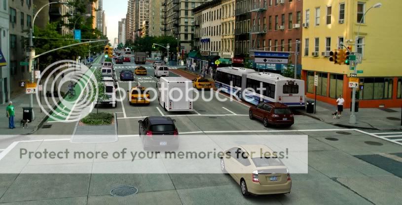
Here is a look at what the streets might look like when finished:
BRT or fancy bus lane?
This is “Option B” of the two under consideration by the NY Department of Transportation in the project named the Select Bus Service and what isn’t shown in the image is that this and Option A both have the bus lanes shared with right turning traffic at every intersection and bicycles with left turning. The other option actually has parking on the outside of the BRT lane! Very poor as the aim is to reduce the travel time and increase the ridership.
To me this is still a very car dominated landscape with four lanes of traffic, a lane for parking, narrow sidewalks and what I essentially consider ordinary bus-lanes with the only improvements being stations, faster loading and articulated buses.
The lesson for Auckland, if we choose to develop this level of bus service between busway and bus lane, is that:
- Bus lanes must be continuous, as grade separated as possible, with lanes extending up to the intersection;
- Priority at traffic lights;
- Pre paid stations with front and rear loading;
- Specifically branded articulated buses and the elimination of parking.
Something to keep in mind for the upcoming Dominion Road upgrade, one of the best candidates for this type of intermediate service methinks.

 Processing...
There’s quite a decent looking BRT upgrade planned for Geary Boulevard in San Francisco – a route that carries around 50,000 bus passengers per day. More info here: http://www.sfcta.org/content/view/40/143/#StudyArea
A pic of what it might look like:
The grade seperated cycleways in New York shown above (although very rare at present) are pretty nice from what I could see. New York IMO is seriously lacking in cross town services (with most subway lines running from top to bottom) which is perhaps where these bus lanes are hoped to help.
I much prefer SF’s
I much prefer the middle design though:
http://www.sfcta.org/images/stories/Planning/GearyCorridorBusRapidTransit/images/website_center-center_sim1.jpg
I must admit I also don’t quite see why see so much of Dominion Rd needs to be widened when there is a huge median down the middle (http://www.aucklandcity.govt.nz/auckland/transport/dominion/images/dominionrd.jpg). With middle running of buses this median could be removed and used for creating the space for bus stations and cycle lanes – or am I missing something?
Doing either of the San Fran options would take the median and most of the centre two lanes. This would only leave one lane each way for general traffic and cyclists to share and I imagine that the residents would be up in arms about this as there would be no space for parking where as now I think there is parking after hours (could be wrong). I also imagine people on the many side streets would fight to not to lose the ability to turn right out of their street across the traffic as these options would exclude that. In saying all of that I really think this should happen and think the option Jarbs linked to about is better as it physically separates the general traffic from the bus lanes, this reduces the chance of cars inadvertently using the lane (there are some drivers out there who ignore bus lanes as they think they have a right to the entire road)
Of the NY option I think the seperated bike lanes are great and if something similar was done here would likely result in a big increase in the numbers of people cycling. If we went down the path of seperating cycling lanes from traffic could they be put together on one side of the road to save space rather than a lane on each side like there are on some streets?
If it were up to me we’d have a grade seperated bicycle lane (like the NY photo), grade seperated BRT lanes (like the San Fran photo) and two lanes of general traffic… Making cycling and catching the bus much faster than driving…
That is half the problem Matt – Auckland treats it road space as a parking lot. As far as I am concerned moving vehicles, buses, pedestrians and cyclists come first and “if” there is any room left after that road side parking.
Well Dominion Road once had a tram line going along it. Let’s find an aerial which shows how that looked, and do it again.
Scott I agree, I think it is a shame that these people can’t see the benefits.
The ARC mapping system used to have the old aerial photos on it. However can’t seem to find them on this new version thats come out. Pity as the 50’s photos were fascinating, showing how the city developed.