A few months ago I took a look at what was happening with ridership at train stations ahead of the City Rail Link opening. I also asked Auckland Transport for data on Busway stations.
So here’s a similar look at what’s happening with the Northern Busway stations.
To start with, let’s look at a bit of history of the busway and ridership along it.
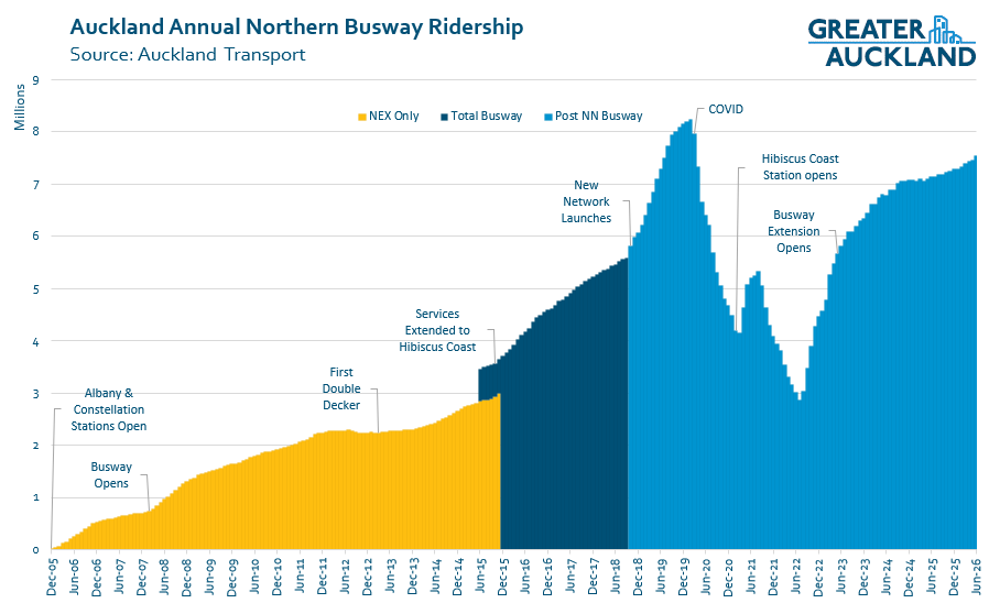
- In November 2005, the first Northern Busway stations opened – Albany and Constellation – with the new Northern Express (NEX) buses running along the motorway shoulders between those stations and the city, much as is now happening with the WX1 on SH16.
- Then in February 2008, the Busway itself opened – along with the Sunnynook, Smales Farm and Akoranga stations – resulting in a surge in usage.
- In March 2013, Auckland’s first double decker bus was introduced; they’re now a staple on many of Auckland’s bus routes.

- While the Northern Express is the main service along the busway, there are a number of other services that use it for part of their journey. A prime example of this is the 83 which runs along the busway between Constellation and Smales Farm and so can be used for trips between those stations.
- In mid-2014, Auckland Transport started reporting on not just the NEX but all ridership along the busway.
- In late 2015, some NEX services were extended to the Hibiscus Coast along with one of the first rollouts of the new bus networks. Originally it was just some basic bus stops on the side of the road, but in early 2021 a proper station was completed.
- October 2018 saw the launch of the new bus network for the North Shore. Along with improved feeder services came a major change for the busway itself: a second Northern Express route, this time servicing midtown and the universities in the city centre. That gave us the routes we have today, the NX1 and NX2 – with the NX1 being the busiest bus route in the country and the NX2 not far behind.
- May 2022 saw an extension of the busway itself from Constellation to Albany, providing a 10km dedicated busway from Albany to Akoranga. The original intention was for a new station to be built and opened at the same time at Rosedale. This has suffered repeated delays, and has only just recently started construction and is not due to open until early 2028.
- As with all public transport, the COVID pandemic knocked ridership around. Northern Busway usage peaked in early 2020 at 8.2 million trips. And, as of June 2026, ridership is back to about 7.5m trips or about 91% of pre-COVID levels. This is far above rail recovery, which was at just 65% in June – and only a little bit behind overall bus recovery, which as of June was sitting at 96%; though that is in part due to new routes since COVID, such as the WX1.
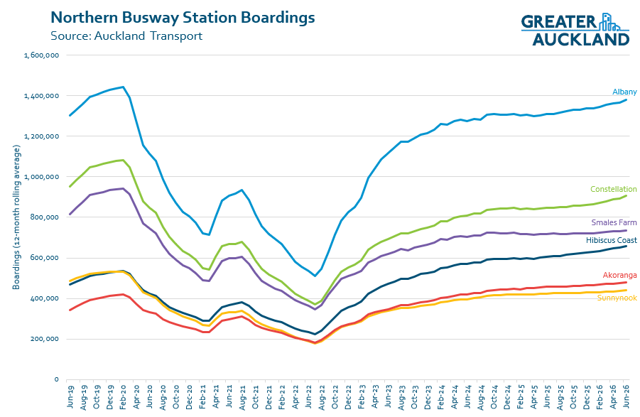
 The data Auckland Transport provided allows me to break down the ridership by station. You can see below how it has changed over time. Note: I’ve excluded boardings from the city centre, as around 82% of all busway trips are to or from the city, so including that data would completely overshadow the chart.
A couple of things stand out.
- Just how much busier Albany is than all of the other stations. With over 1.35 million busway boardings last year, it is head and shoulders above Constellation in second place with just under 900 thousand trips.
- The biggest mover is Hibiscus Coast, which will largely be due to the proper station opening in 2021. As a result it is up 21% on pre-COVIDlevels.
- Akoranga has also improved compared to before COVID, being up 13%. One of the key factors behind this is likely the upgrading of the 942 to become the 94 frequent service. Prior to the pandemic, the 942 carried 480k annual trips. It was back to over 460k when it was replaced by the 94 in July 2024. The 94 it is now carrying over 700k trips annually, and a factor in that will also be the huge growth in population around Northcote.
- Smales Farm has had the lowest recovery, at just 78%.
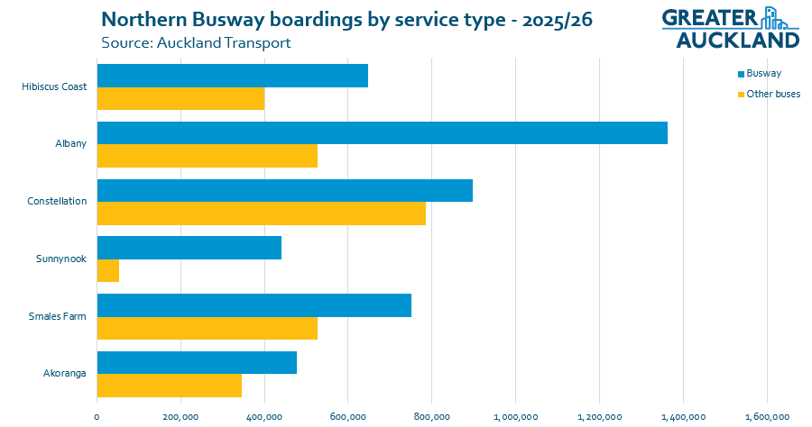
- The combined number of boardings at just the Busway stations for people travelling on the Busway is 4.58 million trips.
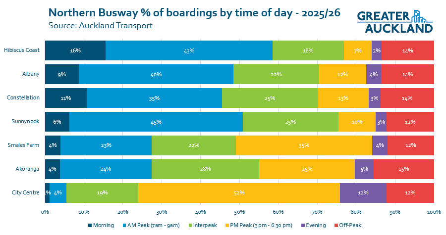
The data also allows us to see trips by the time of day. Auckland Transport says the morning peak is counted as 7am to 9am and the afternoon peak from 3pm to 6:30pm. The off-peak figures include weekends and public holidays.
A couple of things that stand out to me in this:
- Generally, the further out you go from the city centre, the more early morning boardings there are.
- There is a marked difference in pattern for Smales Farm and Akoranga compared to the other stations. The latter are clearly much more commuter-focused, while Smales and Akoranga have much more balanced all-day usage. I suspect a large part of the Smales boardings being stronger in the PM peak is massive influx of students it gets in the afternoons, most notably from Westlake Girls High School which is right next door.
A lot of focus often goes on the provision of car parking at stations – as Councillor Maurice Willianson complained about recently – so it’s interesting to consider the impact of available parking on station usage.
Using the time-of-day data above, I’ve taken just the morning and AM Peak usage for each station. That said, in reality a lot of the interpeak usage will be just after 9am and should probably be counted too.
Dividing that morning usage by the approximate 250 working days a year gives us an average number of boardings each weekday morning at these stations. This is shown below, compared to how many carparks are provided.
| Station | Carparks | Est. Weekday morning Boardings | % of trips from Park & Ride |
| Hibiscus Coast | 604 | 1,541 | 39% |
| Albany | 1,210 | 2,670 | 45% |
| Constellation | 335 | 1,648 | 20% |
| Sunnynook | 0 | 896 | 0% |
| Smales Farm | 0 | 828 | 0% |
| Akoranga | 0 | 527 | 0% |
Another interesting angle is that all busway stations – except Sunnynook – are major interchange stations. As noted earlier, there are around 4.58 million boardings from the busway stations for trips along the busway. But there are also another 2.59 million trips from these stations on local buses.
While some trips on local buses to busway stations will be people visiting destinations around the stations, many will also represent people transferring from busway trips.
Finally, I added the busway stations to one of the charts I included in my rail ridership post. And, as you can see below, there’s quite a stark difference in boardings.
I think there are two key reasons for this.
- The busway consists of six stations covering a large area, so the ridership is more concentrated.
- The rail network was still in a recovery phase – as noted, at the time of the latest data in hand (June 2026), rail was at only 65% of pre-COVID levels. That’s due in large part to all of the work on the network.
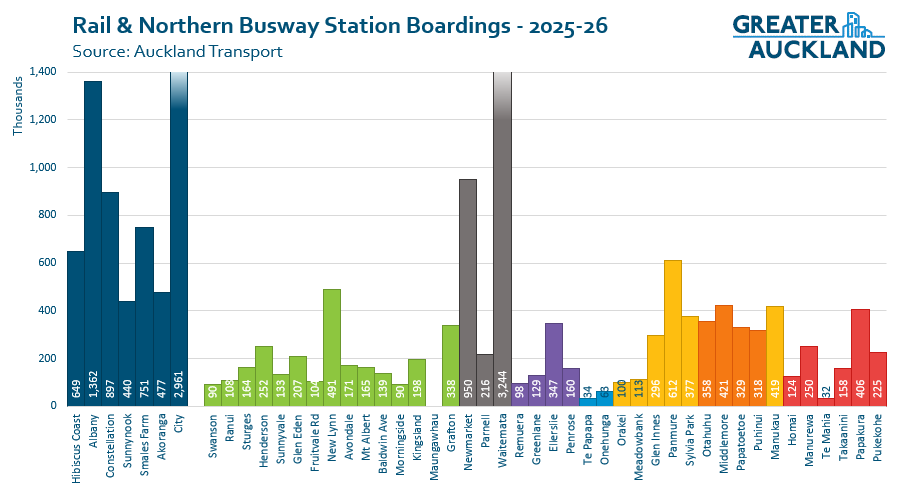 We know there’s been huge growth in rail usage since the City Rail Link (CRL) opened in September, with Auckland Transport stating in a recent press release:
Waitematā remains the busiest station on the network, while key transport hubs including Panmure (+42%), New Lynn (+47%) Sylvia Park (+56%) and Newmarket (+17%) have also recorded strong growth, highlighting the benefits of a more connected network.
So, that would suggest that at least stations like Panmure and New Lynn are now likely to be back in line with some of the busier busway stations.
It will be fascinating to look at this again in a few years, as I expect the CRL effect to change the results significantly. It would also be great to be able to add in the Northwestern and Eastern busways in the future.
Curious to hear what else readers spot in the data, and what questions you might have.
Greater Auckland’s research and advocacy is powered by hundreds of hours of work each month, and your support helps keep us going! We warmly welcome your donations, and are always open to offers of guest posts, practical help, and pro-bono expertise.
Another great way to support the kaupapa is by purchasing and wearing our Greater Auckland merch. Allow a week for delivery – and remember these are print-on-demand (no returns), so double-check your sizing before ordering!

 Processing...
A lot of the early patronage at Hibiscus Coast is driven by the Park and Ride. If you want to use the Park and Ride, you have to be there before 7:30, better at 7am to still get a spot. From 7:30 onward traffic also gets really bad around the area. It would be great to extend the busway all the way to Silverdale.
They’re working on that sort of by building the PM bus lane to the Silverdale exit. Seems to be taking a while and likely costing more than it should, but overall is a great idea and will speed up buses allowing them to skip most of the giant queues.
Yes, good initiatives. Something similar for the AM peak towards the city would be nice, too. I thought about having the busses run via Snowplanet and create a new on-ramp for busses only from the Snowplanet carpark.
Probably cheaper and easier to allow buses/emergency services to run on the shoulder but put a 60km/h speed limit (or whatever is appropriate) so they only use it when traffic isn’t free flowing.
Although that’s what I thought the other bus lane was going to be.
The whole situation is getting ridiculous for the bus with new developments and more traffic in the area.
Leaving Hibiscus Coast Station: Wait at the traffic lights, wait in morning peak traffic (going south), or go through 2 roundabouts and an additional set of lights going north.
Arriving at Hibiscus Coast Station: get stuck in traffic going north (a little improvement expected with the new lane, although there probably will be queues at the Penlink intersection once open), go through 2 roundabouts and 2 sets of lights to enter the station… This currently can easily take 10 minutes from the start of the off-ramp to the station.
I think the Silverdale interchange is a prime candidate for a diverging diamond interchange. There is room for it, it can reuse the existing bridge and ideally a second bridge built beside.
Would solve most of the traffic (sort of, as the queues would just be moved to the next intersections but it would reduce motorway congestion), and relatively cheap. I don’t see a better way, as other sort of interchanges would involve far more infra. This just involves pavement and a 2-3 lane bridge to the north (depending on traffic projections as although they need 3 lanes west to east I’m not sure if they’ll need 3 east to west).
Also has the added advantage of providing a safe walking/cycling route across the motorway compared to today’s monstrosity. Sure it’s mostly fields today but the plan is for it to be continuous urban sprawl.
Seems like the problems you are talking about will also be faced by the NW Busway – getting to the stations at Lincoln Rd and Te Atatu will be tough- no bus priority is planned or considered.
Very interesting how sunnynook – a mainly walk to type station – has more annual ridership than most train stations in Auckland.
Would we be able to get a post on general road traffic volumes since CRL opened? It would be interesting to see data on how much less traffic there is.
How much Sunnynook use is 906 and 907 transfer?
I wish they had a trip leaving from Silverdale to the city @midnight and ideally 11.30pm as well. Ideally every night, but Fri/Sat would be fine.
As the schedule is aimed exclusively at getting people from the CBD to Silverdale rather than considering people could be wanting to head the other way, and there is no practical other way to get back to the city as scooter areas + no safe roads + no harbour crossing makes it impractical.
There do seem to be services to the city from Albany at night.
Maybe add a clarification to that table on % trips from Park and Ride to clarify that the percentage only relates to morning trips from the Park and Ride. I first read it as % of the total trips from Park and Ride rather than just morning trips. I can see people replicating this table and arguing tha without the park and ride Albany patronage would be 45% lower overall.
All this constant growth in patronage and yet somehow there is basically no density being developed around any of the station?
Even at Snakes Farm, it’s a sea of car parks rather than buildings, what has gone so wrong
It’s next to a motorway so it was never going to be a serious candidate for density. Much like Perth’s newer train lines it was designed from the beginning for connections.
It has a really poor layout for connections though. It is too far from Northcote Road so east west buses have to detour. And it is also designed as if it is in the middle of nowhere: instead of buses simply going around one of the blocks in Smales Farm, they have to go on and off the busway.
Is it possible to get tag on/off data from non-busway/local route stops across all routes that happen at busway stations? That will allow us to gauge transfers seperately from parked cars and other walkups.
That’s exactly what the second to last chart is, the blue bars are busway boardings at those stations, the yellow non-busway buses
For Smales Farm a part of the lower performance is probably due to bus 94 being routed to Akoranga instead of Smales Farm.
Overall it is pretty weird for this station to perform poorly. It is basically North Shore Central Bus Station, if you look at a map it sits near a point where half a dozen directions naturally converge.
The feeder buses are a huge problem at the Stations without park and ride. Mine is every 30mins….from the station mostly and an indeterminate time at the busstops. Nothing worse than working in the City, arriving at a station and your feeder just leaves the station while the you have to wait another length for the next feeder bus. Some people drive to a park and ride station instead. Also as at Smales Farm station anything after 2.45/2 50pm is a nightmare as its not adults that are allowed to board the bus first, it’s school children pushing their way through and sometimes it’s hard to get on a bus. Imagine the elderly in that situation. Also waiting 30mins in the evening after a event in the City, a women sitting in the cold, no security guards, homeless people sometimes and waiting for the feeder bus, or, walking home in the dark because the last bus has left
I find it intriguing how well the busway has been coping with patronage higher than much of the heavy rail network. These statistics shed new light on the discussion on whether to convert the busway corridor to light/heavy rail.
I used to be in favour of heavy rail or light metro for the North Shore as well as CC2M, but comparing Seattle and Vancouver’s transit expansion options I came to realise that light rail technology is more flexible, and capacity issues can be somewhat mitigated with grade separation. As discussed earlier on this blog, Perth has done well with heavy rail in motorway alignments, but they have much flatter geography, so Seattle and Vancouver are a better comparison.
Grade-separated busways are alright too, but at some point we would need a tunnel through the city centre like Brisbane, and a viaduct/tunnel from there to SH20, at which point it would be essentially light rail anyway, but with less vehicle capacity.
Off topic, but why wasn’t a Dominion Rd viaduct option considered during the ARL debacle? 🙂 I was all for a city centre light rail tunnel and grade-separated alignment elsewhere, but couldn’t understand the need for a tunnel down to Mt Roskill.