A few months ago Auckland Transport finally started talking about the need to replace level crossings on the Western Line – something I think will become glaringly obvious in a few months once the City Rail Link opens, especially when frequencies increase, likely early next year.
The discussion was mainly in the form of a short survey, which I understand was mainly about starting to raise the awareness of the need to replace the crossings.
While we don’t yet know what is proposed for each crossing, we do know that AT currently don’t expect to start removing these crossings until the early to mid-2030s, and that they plan to start with removing the crossings on the Inner West – between Maungawhau and Mt Albert – first followed in the future by the crossings further out on the Western Line.
AT have recently updated their website with new details about the Western Line level crossings, including both some of the feedback from that survey and some of the challenges with removing each crossing that they’ve already identified – which alone helps to shape up what the solutions might be.
Inner West
As noted, the Inner West crossings include the six crossings from Maungawhau to just past Mt Albert.
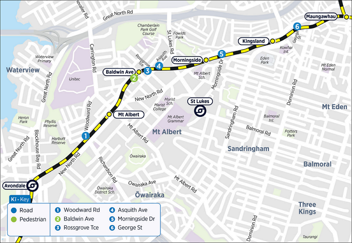
While most of the people who responded said they preferred to keep the crossing as is, AT say:
This section of the Western Line carries the most train passengers, as it is closest to the city centre, so it is important that it works well and that safety and rail reliability is improved as train services increase in the future.
They also say:
Generally low numbers of drivers, cyclists and pedestrians use George Street to travel between Dominion Road and New North Road, and to get to and from businesses and homes in the area. The crossing is in a physically constrained area so potential solutions may be complex and expensive.
And, regarding the challenges:
Steep gradients on George Street mean that a road overbridge would require long ramps, which could affect nearby properties and driveways. The short length of George Street and its steep gradient mean a road trench is not feasible here.
The rail line at this location sits very close to other major rail structures such as the CRL tunnels and Dominion Road overbridge, which means it is very difficult to change track levels.
This would likely suggest that the focus here will be on closing the crossing and perhaps looking at how to make alternative routes more viable. The real long-term solution here is the removal of the Dominion Rd flyover and replacing it with a normal intersection – this would both enable the movement that George St currently provides and frees up land for more development close to the city.
It seems clear that AT plan to grade-separate the crossing here, given the road’s role in the wider transport network. Especially as they note it’s used by a number of bus routes, and that it’s also used as a diversion route when events are on at Eden Park. They also say:
We are also investigating quick, low-cost improvements at Morningside Drive to improve traffic flow.
As well as noting strong support for separating the crossing, a couple of points that stood out to me:
- there is a strong connection to the train station, with approximately 75% of users accessing it via this crossing compared to other entry points, highlighting its critical role in station access
- there is some openness to relocating the crossing, provided it delivers better overall outcomes.
That last point is interesting. I’ve suggested before that perhaps the crossing should be realigned to a new four-way intersection with Inwood St – along with adding stabling for trains, to better support major events.
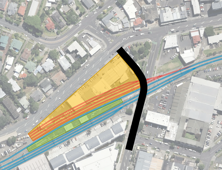
Asquith Ave, Rossgrove Tce and Baldwin Ave Station
These three crossings are rightly being treated together, given how close they all are. But they’re the first place where AT are going to have an interesting challenge on their hands, as they say:
The surrounding area is mostly residential, so large changes to the road or rail environment could result in visual, noise and property impacts.
Raising road levels in this area could affect natural flood paths, potentially displacing flood water and creating wider impacts beyond the immediate site.
It seems a strong part of the feedback was about maintaining local access, including east-west access via Rossgrove Tce, and so any potential closures are likely to get a lot of push back from the community.
One interesting bit of data AT share is:
We know from HOP card data that a high proportion of station users at Baldwin are children, secondary or tertiary students (around 45%), highlighting the importance of safe and reliable walking access for everyday school travel.
AT talk a lot about this route being important for local connections and also carrying a large amount of traffic, which means there would be wider impacts on already busy nearby streets if the crossing were to close. They also note that it’s unlikely that there could be changes to the vertical levels of the rail corridor due to the nearby stations and potential future rail connections (Avondale to Southdown Line).
The crossing carries high volumes of through traffic, meaning any disruption or diversion can have wider impacts on surrounding roads, particularly New North Road and Carrington Road, which are important connections.
Traffic numbers are expected to experience increase as nearby development progresses which will place extra pressure on the crossing and surrounding road network in the future.
Changes to the vertical levels of the rail corridor at this location could affect nearby stations and future rail connections.
Outer West – Avondale to Henderson
AT have now divided the Outer West up into two sections: Avondale to Henderson, and Henderson to Swanson. Perhaps they should have left the Outer West moniker on the last section, and the Avondale to Henderson part could have been called the Midwest?
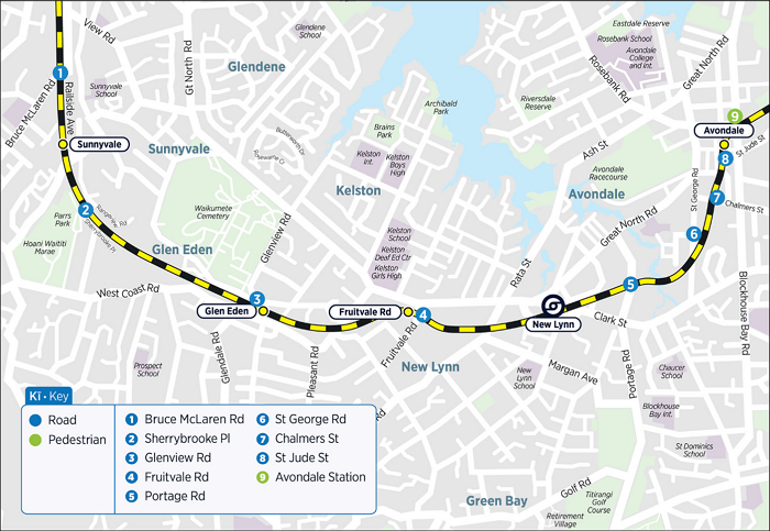
As with around Baldwin Ave, the crossings at the Avondale Train Station, St Jude St, Chalmers St and St Georges Rd are being treated together, and it seems clear some of these crossings will close:
Due to how close the crossings are to each other, it is likely that there will trade-off decisions about which crossings remain open or are closed.
Avondale Station is one of the busier peak-period stations on the Western Line, and AT say most are accessing it via Crayford St:
- train tag-on data shows around 71% of station users enter or exit via this crossing, highlighting its critical role as a walking and cycling connection into the station
- around 27% of station users are children, secondary or tertiary students, reinforcing the importance of safe, accessible and reliable crossing conditions for everyday school travel.
A big challenge here is St Jude St, which provides an important road connection between Gt North and New North Roads, and as such is one of the busier road crossings in Auckland. However, it is also a steep street which AT note could limit potential solutions.
For both Chalmers St and St Georges Rd, AT talk about them being more about local traffic and how the way the angle of the rail line intersects with the road creates additional challenges with any crossings.
This is another crossing that AT seem to be saying will be grade-separated, especially with the comment about Olympic Park:
Changes to ground levels could displace flood water, creating environmental risks and potential contamination issues within an established light‑industrial area.
Portage Road functions as a freight route, meaning heavy vehicles frequently use this crossing. If traffic is diverted, nearby local streets would likely need significant upgrades to safely accommodate increased volumes.
Olympic Park, located to the east of Portage Road, relies on vehicle access from Portage Road, and this must be maintained for everyday use and events.
The feedback also showed strong support for separation.
This is another crossing that there’s likely a good chance AT will seek to close, but with grade separation for pedestrians and people on bikes, with AT saying:
Fruitvale Road is a primary walking route in AT’s future network plans and is closely tied to access to Fruitvale Road Station.
It carries relatively low volumes of local traffic accessing Great North Road, West Coast Road and Titirangi Road, but plays a big role for people walking and cycling.
This is reinforced with these comments:
Steep gradients on Fruitvale Road and flood-sensitive land limits how much the road or rail levels can be changed without wider impacts on properties.
Larger infrastructure changes, such as road overbridges or trenches, would come at a high-cost relative to the small number of users who would benefit. This is particularly true given the residential setting and nearby alternatives.
There are already grade separated road and rail crossings nearby at West Coast Road and Titirangi Road, which accommodate most cross-railway movements in the area. This reduces the need for Fruitvale Road to carry larger traffic volumes.
Glenview Rd is another challenging crossing with high traffic volumes, which also provides access to a station and has a lot of geometric constraints.
West Coast Road is located just 50 metres south of the crossing, which can lead to traffic queuing from the West Coast Road and Glenview Road intersection. The close proximity of this intersection to the rail line makes options such as overbridges or trenches difficult to build due to geometric constraints.
Glen Eden Station is located directly beside the crossing, further increasing the complexity of any changes.
There are also several key land uses nearby, including an apartment building, fire station, school and cemetery. Access to and from these locations must also be considered.
AT say they had strong support for separation here too, and it’s likely any solution is going to be very costly. They include some interesting stats about the station:
We know from HOP card data that:
- Glen Eden has the highest peak-period station activity of the Western Line stations analysed, reinforcing the importance of this crossing for daily station access and movement through the town centre
- around 25% of Glen Eden station users are children, secondary or tertiary students, highlighting the importance of safe and reliable access for students and young people.
Sherrybrooke Pl is one of two crossings on the Western line that are the sole point of access for a small number of residents.
The rail crossing is the only legal access available for Sherrybrooke Place. Removing the crossing would require a new access route or result in significant impacts on nearby properties.
The crossing runs alongside Waikumete Stream, near Parrs Park, by an area identified as Open Space Conservation Zone and Significant Environmental Area. These zones limit where changes can be made and add environmental considerations.
The road network sits close to the rail corridor on both sides, which limits options for grade separation.
Bruce McLaren Rd is another crossing that is likely to be grade-separated due to the important connection it provides:
Bruce McLaren Road is a priority freight route, meaning any restrictions or closure would have significant impacts on business access and servicing.
Redirecting freight traffic could shift heavy vehicles onto nearby residential streets, creating safety, noise and amenity issues. It could also require upgrades to surrounding intersections.
This crossing is also close to the priority urban development area of Henderson, so future options need to consider how best to integrate with planned growth and redevelopment.
The rail corridor in this area is already constrained by nearby stations and the existing stabling yard, limiting the potential for a rail viaduct or trench. There are also plans to expand the stabling yard, which will require additional space.
While visual impacts may be less sensitive in this industrial area, construction complexity and disruption to the transport network remain important considerations.
Outer West – Henderson to Swanson
Auckland Transport suggest these crossings are likely to be dealt with later, as train volumes will take longer to reach the threshold for grade-separation. This also suggests AT don’t plan on delivering the frequency improvements the CRL enables past Henderson.
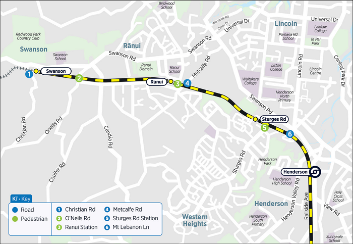
Much like Sherrybrooke Pl, this crossing is the sole point of access for a small number of homes as well as the Corban Estate Art Centre.
The surrounding area includes parks, streams and environmentally sensitive land, which limits where new connections can be made and adds to environmental constraints.
Larger changes to the road or rail environment, such as overbridges or trenches, could have significant impacts on nearby properties and the local streetscape, particularly in this quiet residential area.
This is a crossing I pass over multiple times a week as part of my commute. AT notes it “is an important link for people walking and cycling, providing easy access between platforms and from nearby neighbourhoods“.
The crossing is closely connected to the station layout and Park and Ride, so any changes would affect how people move between platforms and access the station.
While alternative access is available from Sturges Road, it involves longer walking distances, which may reduce convenience for some users.
Significant changes, such a bridge or underpass, would likely require additional land to accommodate ramps or bridges that meet accessibility requirements.
They also include these stats:
We know from HOP card data that:
- Sturges Road Station has one of the highest peak-period station activity levels of the Western Line stations analysed, reinforcing the importance of reliable pedestrian access to the station
- around 38% of station users are children, secondary or tertiary students, highlighting the importance of safe, direct and well-connected walking access for everyday school and education travel.
It’s not surprising the student numbers are so high, given the number of schools nearby.
While the crossings in the Henderson to Swanson section are likely to be delivered later, it’s possible AT might have to do Metcalfe sooner as it is now the busiest crossing for road traffic in the city – and probably the country. A new traffic count just a few months ago recorded almost 18,000 vehicles a day using this crossing on weekdays. That’s more than most of the highways the government want to replace with multi-billion dollar four-lane expressways.
Next to the level crossing is the Ranui Station, and a pedestrian crossing at the eastern end will also need to be addressed. AT say about 67% of people accessing the station do so via this crossing.
Metcalfe Road and Rānui Station are in a flood-sensitive area. This limits the ability to lower the road or rail line, such as building an underpass.
The road crossing is close to the station, so any changes need to consider station operations, platform access and passenger safety.
Because the road and station function together, improvements in one area may require changes in the other. This is important to maintain safe and convenient access for people walking and cycling.
Significant changes, such as building a bridge, would likely require additional land to accommodate ramps or bridges that meet accessibility requirements.
AT originally planned to close the pedestrian crossing at O’Neills Rd at the same time they closed a bunch of other pedestrian level crossings a few years ago. However there was a lot of community pushback about O’Neills, so it has been upgraded and left open for now. AT claim there are alternative walking routes, but they’re only viable if you consider a 1km+ detour a viable alternative.
The number of people using this crossing is low, and there are alternative walking routes available. This means major upgrades, such as a pedestrian overbridge, may provide limited benefit when compared to the cost and environmental impact.
However, community feedback has highlighted strong opposition to closing the crossing. Community concerns, especially around community severance, will be considered alongside funding constraints.
The final crossing on AT’s list is at Christian Rd – which is notable because this crossing, just west of Swanson Station, isn’t even on the electrified network and sees only two freight trains a day at best. However, it is on the list because AT say there is a future need for more train stabling near Swanson, so they’re investigating this crossing just in case it is eventually decides to put the stabling west of Swanson.
What else have you noticed about these locations, the local challenges, and has AT missed any key points for discussion?

 Processing...
As I have been advocating for a programme of level crossing resolution for 23 years it is pleasing to see that the issue has at last moved from the back burner. But Council and Council have focussed on the southern line which will be fully grade separated (at least as far as Papakura) by 2032. So unless there is a new source of money work on the Western line remains completely unfunded except for investigation and design work. In Matt’s analysis of the early commentary from AT I have just a few brief comments. I attended several of the recent open days but was disappointed to learn nothing much new – the objective was to get the public thinking and to note any comments. I am pleased to see some thinking about linking closure of George Street (extremely tricky to grade separate) with replacement of the nearby Dominion Road interchange with a bog standard cross-roads intersection. I find it curious that Woodward road is considered close to the nearest rail station – it is about a kilometre SW of Mount Albert and even further from Avondale, so grade separation is in fact quite feasible. Jude Street is just too steep to consider grade separating so should be closed once a suitable new route can be found to link Great Noth Road West of the Avondale roundabout with New North Road. Sherrybrooke Road level crossing should also be closed and replaced with a new link road across the creek. I am looking forward to some actual proposals/options from AT so we can get into the details.
I’m sceptical that there is a physically feasible, politically viable alternative to St Jude St.
Rosebank Rd is the easiest, but would funnel a large amount of traffic directly through the Avondale town center and bus interchange, Chalmers St is a quiet residential road with more or less the same geometry constraints, and that’s all there is as far as existing RoWs.
Maybe the right answer is upgrade Wolverton St somehow, but that’s enough of a detour that I’d be concerned about rat running and the political case.
I’d love to a skyrail solution here, but I think my money is on Avondale station + St Jude St getting trenched.
How deep is Waterview tunnel because a trench might clash
~700m between Avondale station and the tunnel at 1.5% grade allows for a level change of 10.5m which means the tunnel shouldn’t be an issue, maybe an issue for building the Avondale Southdown junction if it is going to be a flyover.
Yeah I think separate St Jude, and close Chalmers, St George once complete, add pedestrian crossings to those.
Also close Portage and improve alternatives via existing Veronica St crossing. There are already five vehicle crossings through New Lynn, there does not need to be another one, optimise the network instead.
Yes and when closing Portage look to tie in with Te Whau Pathway so that those on foot or bike retain a crossing.
My two cents on St Jude is to extend it along the rail corridor from Donegal Street (or just before and make Donegal a culdesac) and bridge over the rail further to the south and have the ramp down around where Ahiriri Ave is, connect with St Georges Road and then push through the Great South Road.
I admit it would require a fair bit of land acquistion.
Won’t be popular but probably going to need some sort of Melbourne style sky rail. How that will ever get past the powerful nimbys I have no idea.
Perth used the elevated line solution for the Armadale Line, eliminating several dangerous crossings.
There is a problem with elevating extensive sections of the Western Line as it is also a freight line so the structure supporting the track would need to be stronger than for a purely passenger line. Not impossible – just considerably more expensive.
It’ll also be more complicated if Avondale to Southdown ever happens.
That makes no difference. The line is rated at 18 tonnes per axle regardless of what the axles are carrying. All structures on the network meet that threshold.
“Won’t be popular but probably going to need some sort of Melbourne style sky rail” Why do we “need” that, when that’s going to be a magnitude more costly?
It may actually be cheaper. Grade separating multiple roads in south auckland is costing literally hundreds of millions of dollars because you have to build wide bridges and tie them back a long way and buy lots of property. Elevating an existing track on an existing alignment may be cheaper.
Glen Eden is absolutely ripe for an elevated section with road and active connections underneath. They probably won’t do it, though, because they don’t like moving both corridors at once. One or the other. Woodward Rd will be the same. The best solution is to flatten the rail hump between Mt Albert platform and West of Woodward, then bridge the road over. But they won’t because that means both modes closed for long periods. So they’ll leave the rail line and make an extra ugly and inconvenient road bridge about three metres higher than it really needs to be.
The value of the work Matt L has done for Auckland Transport/Council now over many years is immense.
And they have got it for free.
Compared to the millions they have shelled out to consultants to recieve work of condiferably more variable quality.
Thanks Matt
Accelerating this programme, and tightening it (ie more closures and place upgrades, and fewer massive crossing structures, reducing cost and impacts) would be a very good platform for the next mayor to run on.
And yes – Inner West, Midwest, and Outer West.
inner west, mid west, and beyond sturges, the wild west … lol
+1000
I use George Street a lot, so will personally be sad if it closes (same with Wynyard Road which has already turned into a pedestrian overbridge only). But I get it in the grander scheme.
Baldwin Ave is interesting. AT have noted the high number of tertiary students using this station – this is likely to change in the near to medium term. Auckland Institute of Studies has been sold and are only currently leasing their nearby Linwood Ave campus. The site itself is now up for sale and is zoned for apartments and terraced housing. So I’d wager the number of tertiary students using Baldwin Ave will likely decrease to almost zero once AIS inevitably moves out, taking their ~1000 students with them.
It would be interesting how they would tackle the Asquith Ave crossing as there is a big gradient change to / from the crossing. Perhaps a good application of an underpass, but need to smooth over the new angle of the road to go under.
Asquith definitely needs to be a wide underpass. Unfortunately road under rail is strongly discouraged due to the risk of bridge strike and the high consequences of even a minor incident. You’d think that was a “surely not” matter in this day and age, but it happens far too frequently. You can always count on some idiot hauling a digger to forget that he’s towing 4.3m instead of 4.1m and rip the guard rails out of their footings. Seen it dozens of times.
There are numerous ways to mitigate, but Asquith is a narrow corridor on very hard bedrock, so none of it comes cheap or easy. They need to be brave and firm and very clear with the locals.
Oh, sorry, *tertiary*… I didn’t read properly, don’t post my previous comment!
Baldwin Ave is also used by MAGS and Marist students. Don’t forget about them!
Grade separations have been an elephant in the room for a very long time. I was involved in a series of studies for ONTRACK / ARTA / Auckland City Council around 2005. The fact that it has not been dealt with prior to the CRL opening is mind boggling. Pass the buck until it can’t be passed anymore seems to have been the strategy – amounting to over two decades of deferral, failure of process, and a lack of institutional follow-through. Does the estimated $3 billion cost include the cost of network closures once the work actually starts? It would be useful to see the cost relative to 2005 to understand the additional deferred costs the public will no doubt be asked to pay. Getting Auckland ONTRACK since 2005? Yeah Right.
Political realism of securing funding and approval for CRL could have been literally derailed if design, consultation and funding for LX had stated too soon. Possibly a bit too late starting, but the cancellation of Warkworth – Te Hana might pay for it, along with so much else.
East-West Link route protection has been canned. So we take the small wins 🙂
That one surprised me. Sure, it’s unlikely to ever be realistically able to be funded without throwing our financial future away, but when has that ever stopped the road dreamers from banking a win…
As a declared “de-wheeler”, a person who believes that the wheel was the worst human invention, my opinion can be considered radical, extreme, and potentially overly conspiratorial.
Our trains are electric, so they do not emit toxic fumes into our lungs, or the upper atmosphere.
Electrifying our private motor vehicle fleet is a joke, we have cars constantly parked on our wharves, because we have always been the last dumping ground.
Our city is progressive, in that it seems to electrify our entire public transport network by 2030. For the climate sensitive among us, it feels like we are actually a city that believes in the future.
The CRL gives us a piece of infrastructure that every other city in the world already has, so opens up incredible potential for lowering carbon emissions from the day it is inaugurated.
How about we prioritise the trains, and the pedestrians, and the bikes, and the mobility scooters, mobility motorised chairs, wheelchairs, buses, ferries…OVER the car?
Howabout we do not upgrade any level crossings, just close them, put in a car parking facility withing five minutes walk, and provide a viable transport solution for the majority of our population?
The CRL must be used aggressively to decarbonise, we cannot sit on our hands and wait for our car obsession to recede, because our ports who that cars will continue to arrive here, whether we want to drive them or not.
I live in the Central City, I can access train stations, ferry stations, and bus stops. I can get to Maraetai if I really want to. Many others have proven that with time, public transport can get you anywhere. What the CRL will prove as that you can actually get somewhere faster than driving your own vehicle, so the time space continuum argument will become rail dominated.
I assume that AT is being wish washy about this because we do not need to invite any culture wars back into our city. We are moving towards a future that does not require car ownership, and sinking into a future that makes home ownership very difficult.
Let us stick on the bright side of that imagined future…no more driving in traffic, no more expensive parking, no more excessive fumes to breathe in while crossing the motorway to catch the Ellerslie train at 8.40am in the morning…
DeWheel and all will become apparent…we began walking out of Africa, and we still own those two legs, so instead of sitting in a comfortable seat, IN CONTROL of a little metal box with windows…getting fat…let’s move, like AT says…MIX YOUR GO. Like FIFA says…kids need sixty minutes of movement per day…sit in the middle carriage of the train, it is a jungle gym for kids, what more movement do they need?
bah humbug
You know trains have wheels, eh?
Semi-off-topic, but you do realise that bicycles and trains only work because of wheels?
Road crossings are also needed for pedestrians, cyclists, emergency vehicles, buses, and freight vehicles, not just private cars.
We can’t just cut the city in half like a Berlin Wall.
I think that prioritising trains over roads is exactly what AT is planning – but pedestrians and cyclists also need to be able to get over the tracks, including to use the train itself in both directions. I live near the Baldwin/Rossgrove/Asquith crossings and about 80% of the time I am crossing over the lines here on a bike or walking (often with young children). AT seems to be gearing up to close the pedestrian/bike only crossing at the western end of the train platform – if they do this I will probably end up driving significantly more because it will add an extra 10-15 mins to my walking journey to get to the Rossgrove end of the station (effectively negating any benefit of a faster train service, by the way).
As another commenter has said, you can’t cut the city in half like the Berlin Wall.
With regard to the four crossings nearest to me:
1. Sturges Road- agree completely with the need for alternative pedestrian crossing but at the same location. An underpass here would be most effective, if it was monitored and safe, with the essential linkage, perhaps from the corner of Neta
grove to the corner of the rugby field and up to the park and ride.
2. Metcalfe road- absolutely notorious mess, particularly the cirrent stupid right turn straight from the crossing into Pooks road instead of going round the whole roundabout. While lowering the track is possible- in conjunction with a major stormwater drain to the outfall end of paremuka dam to alleviate flood issues-, the costs of disruption to the rail service and a return to railbuses is not worth contemplating. Suggestion here would be a new and elevated bridge/ combined roundabout grade separated from rail, it might cut off a couple of corners of properties but anything that improves traffic flow and crossing safety in this mess has to be worth looking at. An elevated roundabout would involve a more gradual two stage rise from the flat land on the south, across a flat roundabout and bridge over the rail line, , to the Metcalfe incline to the north, and ramps to the side roads. Access to nearby residences could be via dedicated slip lanes along the sides of the roundabout at existing ground level- alternatively offer a buyout and redevelop the sites. It must be possible to integrate the station with the bus services serving it (Waitakere and Western Heights routes) as part of this upgrade
As a side issue why not invest here in a safe park and ride- the sale of the old goods yard at Carlas Way before the rail upgrades was extremely short sighted, and is now virtually irreversible, but maybe a new park and ride where some of the existing plaster disaster houses are? or even take part of the nearby Pooks Road reserve? Key issue- security; park and rides are becoming notorious for damage and theft, and are a strong disincentive to their use.
3. O’neills pedestrian crossing, a crucial pedestrian link, how about an arched footbridge from one side to the other, oblique to the line, where the ground is more elevated, immediately to the west of the existing crossing. But dont close it.
4. Christian road, remodel this whole section of rail and road separation while the land is still vacant, and while it is beyond the limit of urban rail services. Dont let them build houses on the vacant land, and then later decide to daylight the Waitakere tunnel and extend services to Kumeu; have some foresight do the grade separation in advance while there is vacant land, and do it now.
Side comment, I prefer where possible to take a bus to the station rather than drive down and leave the car, even if it does mean a half hour walk to get the Waitakere service. Unless a Park and ride is secure, it is a risk.
Metcalfe Rd is easily the worst crossing for road vehicles breaching the barriers and other lunatic behavior. Despite it’s designation in a low priority area, it must be considered for accelerated treatment in response to the significant hazard and disruption it presents on a daily basis.
How will the Western level crossing programme affect freight? Will there just be a period where rail freight will be unable to traverse north of Auckland? I’m sure KR has thought about this and wonder how it’s affected decision making over the last two decades of deferral.
It survived the year the line was out of action after Cyclone Gabrielle. It will be passenger services that ultimately ensure that the line isn’t out of action for long periods of time.
Why would it affect freight at all? I mean this essentially increases capacity and improves safety, which is a boon for freight as well (though of course the added capacity is mainly (all?) intended for passenger services, there is nothing I can see that has any inherent downsides for freight trains?
I don’t know, that’s why I’m asking. If it’s not an issue, then no problem.
A very very very low % of freight is actually moved by rail.
But the upside potential is massive, of course. If you don’t allow for that, then you have stuffed the future.
First needs KiwiRail and OnTrack to have a fundamental change of attitude and management…
Yes there will be periods of closure to achieve this program, but the recent developments along the western line of electrical isolation and alternative routing options make for greatly reduced disruption. It will be possible to continue operate on a single line through worksites to a degree not previously possible.
To help everyone think about these:
1) Rail trench is just not feasible at most of these and, if chosen, would disrupt rail freight and passenger service just as it builds with CRL opening.
2) Don’t forget 3D in ideas. Takaanini crossings give a good picture of the length of bridge ramps needed, using 8% for paths and freight as maximum gradient. Got to get over those wires.
3) We don’t want to put off PC120 development opportunities, whether we like exactly where they are landing or not.
Re 2: This is why underpasses are often more feasible on ramp length alone on an electrified line. With several meters less to go down than a bridge has to go up, the ramp lengths reduce very substantially. Of course underpasses have other design challenges and costs where they score worse than bridges…
Yeah unfortunately underpasses flood and have safety issues.
not many great scenarios here… all very costly and disruptive. I would be inclined to let the ‘smaller’ crossings try to see how it goes when they have to wait all day to get across the tracks. That will likely stop some of the complaining and focus in on practical solutions. The guys in the two ‘islands’ at Sherrybrooke and Mt Lebanon need to be prioritised as they will be stuck at home until after peak hours for the trains. Morningside, woodward, portage road and bruce mclaren will be a challenge. Still, anyone that lived through the old roundabout at New Lynn will remember how great it was when it was resolved. St georges road and Glenview have alternative ways to go now so should just be closed – assuming that the fire station has a way to get across the tracks at glen eden
St Judes I mean
Crossings that can simply be closed will be the last to be closed as they are required to carry traffic displaced by work on crossings to be grade separated. The workflow for Takanini illustrates this well.
They built the Waterview tunnel with the stated benefit of taking cars off the local roads (giving them a better faster path) but it seems this is forgotten and now we will grade seperate Woodward Road to presumably help build the level of rat runners back.
Glenview does not have realistic alternatives
Simplest solution for Glenview is to close to vehicles, add pedestrian over bridge, but leave a truck width route through with a barrier and signals that the emergency services can override, stopping trains and speeding fire engines through when needed.
A bit disruptive to timetable. Would need to find out how many emergency calls they get on average in that direction to work out if viable. A hell of a lot cheaper than anything else.
Oh and while a big change for some drivers, loosing a short cut, but would also simplify and reduce traffic one the main road through the Glen Eden shops a great deal.
It won’t make much difference for drivers, the extra distance more than compensated by better flow on West Coast Rd I reckon. What’s needed is good pedestrian and cycle access and linking the existing Upper Waikumete Cycleway to Glen Eden so that entire catchment (with 3-4 schools) can connect safely. It was done with a pop-up path on Capt Scott Rd but the local board chickened out and reverted to favouring public storage of private goods (parking for houses with driveways and, in many cases, garages)
https://www.robincapper.net/at-level-crossing-survey-glen-eden-level-crossing-closure/
Glenview has multiple options. My preference is to bridge rail over and redevelop the station with provision for a third main. The road can be flattened/lowered to facilitate a minimal elevation, although this will require extended simultaneous closure.
Next best is to re-route around the back of the Manson tower and bridge there to an intersection further down the hill. That could also provide an access point to connect to the houses on the western side of Sherrybrook crossing. $$$$$$$$$$$$
I’ve noticed that in areas of the USA, the rail lines are not fully raised (like the brick arches in the UK), but are just raised up 1-2m above the land nearby, and then the roadways are just lowered local dips down 1-2m, so there is enough room for a car to get through. The full 4m height for highway access is not achieved, so Trucks need to go round the long way. Smaller cross-overs, more often, are far more affordable.
The back way to Henderson around the back of parrs park or carry on along west coast road to great north road. Either of those are definitely viable alternatives… I already regret not doing those anytime I forget and get stuck at that intersection now- mostly just force of habit as I’ve used that road for 50 years I reckon When it changes to more frequent services I would gladly make the change.
The best solution for me is skyrail.
For the super low traffic ones, like Sherrybrook & Mt Lebanon for eg why not have the same solution for cars on these streets as there is for pedestrians at busy intersections? eg a beg button (could be automated like traffic lights). That is the train line has ROW/road is closed/red light until permission is given by raising barriers/green lights. No geometry changes, uses existing tech and road infrastucture and rules, increased safety and minimal decrease in LOS?
This seems like a great interim solution until they gather the budget to remove them entirely.
Looking a satellite map, it seems that creating an alternative access for Sherrybrooke should not be too difficult: bridging over Waikumete Stream to perhaps Woodbank Dr which comes off West Coast Rd. Sure, there’s an environmental cost, but compared to the development to put the houses in on Sherrybrooke, this seems relatively minor. Or if it’s better, the rail corridor could be followed east right through to West Coast Rd where there is rail access by Singer Park.
You could even bridge the other way to Benita Place which would only require buying out maybe one or two properties.
Although Woodbank would be easier as the land is already empty.
As someone using the Fruitvale road crossing, I think closing it to cards is reasonable.
The road saves me maybe a minute getting to the supermarket but the alternatives are obvious.
I think they should leave the crossings from New Lynn to Swanson alone Fruitvale Rd should be left alone can’t separate two halves of the road for residents living there and Glen Eden and Bruce McLaren rd should be left alone to.
“left alone”…. in other words, those crossings should be barrier arms down most of the time for drivers?
There are pros and cons for residents of having the road split in half. The downside is having to drive further for things on the other side of the tracks, the pro is having less traffic in your neighbourhood.
Having lived on a rat run in Auckland previously, I’d take having the road cut in half personally.
Ive lived in fruitvale for over 50yrs an all the cars parked everywhere an new houses with not enough parking plus 24/7 being used as a cut thru street i think cutting the street in 2halves is better than me having to move or loose part of my property an have constant building whilst they alter it
BUT THEY NEED TO FIX THE INTERSECTION AT GLEN EDEN
As the crossing , traffic an pedestrian lights are pathetic for cars
When the trains have past the crossing light stays red an theres No pedestrians !!
My thoughts on the Glen Eden crossing, make it better for people and close it for vehicles
https://www.robincapper.net/at-level-crossing-survey-glen-eden-level-crossing-closure/
AOR can run a more limited service Swanson -> Henderson then full service to CBD to allow for Outer West crossings to be removed at a later date
KR needs to get a cheap kitset pedestrian bridge setup, where they can hook up stairs, ramps or lifts (depending on the site, ideally ramps) and buy in bulk/pre consented, same team can work on the first bridge, get it in place, then move to the 2nd and so on. As otherwise there will be a whole lot of severance with no recourse, driving is fine as you’re just going around the block, but walking/biking makes it a nightmare.
In general, the crossing removals should be done CBD outwards, with specific exceptions if the safety risk demands one being prioritised. When I’m saying pedestrian bridge, should have stairs and ideally a ramp/lift where practical. Lifts should be avoided due to cost reasons.
Inner West:
1. George St should just be closed. Stick a pedestrian bridge over it if practical, but this is a crossing that shouldn’t get a large share of the budget, and should be done first.
2. Morningside Drive it depends on the budget. If there is stuff all budget, then a bespoke pedestrian/active modes bridge (due to the event numbers), reroute the buses down New North Rd instead of Morningside, and extend the 20 loop slightly more so there is no coverage gap. People travelling to/from St Lukes can transfer off the OuterLink/65/64 etc. – the 22 detouring via St Lukes was when there wasn’t frequent buses along St Lukes Rd. If there is the budget, a proper road bridge to Inwood St seems best.
3/4. Asquith Ave and Rossgrove Terrace should be closed entirely. A small section of pedestrian path built between Rossgrove and Asquith on the north side of the line, then a cheap pedestrian bridge built on one (but not both) of the roads – Rossgrove is better for passengers in the station, Asquith is better for longer distance active mode trips. There isn’t the volume to justify building a road bridge, let alone two road bridges, and it will significantly improve the neighbourhoods without the through traffic.
5. Baldwin Station pedestrian bridge – just replace the current west crossing with a pedestrian bridge in roughly the same spot.
6. Depends on budget. If there is no budget, then close it and put a pedestrian bridge in, will make New North Rd/Carrington/Mt Albert Rd intersection worse, but it’s a decision they’ll have to make.
Otherwise bridge it, and buy out houses rather than trying to adapt the bridge at great cost, far cheaper to spend a few million buying a house above market value rather than tens of millions trying to create a bespoke access. If anything, buying a few houses and putting it together as a parcel for a developer to build could reduce the total cost of the project after the sale. KR seems to spend vast sums to not have to buy homes, where it’s significantly cheaper to overpay for their homes and not have to build a complicated solution.
—
7. New North Rd itself – they’ll figure it as part of the first stage of Avondale – Southdown (as they’ll stage it and start from the Western Line end just to leave the Onehunga bit to last), but they need to ensure whatever solution they design works with having a fully grade separated junction there, even if they only build part of it initially.
—
Mid West:
8/9. Close St Judes St, and add a pedestrian bridge there. If there is budget, add a second bridge at the existing pedestrian crossing at the station.
AT can and should get rid of the 5 way intersection where New North Rd ends, and turn it into a T intersection of New North Rd and Blockhouse Bay. Connect St Jude and Crayford St East with painted markings on the road. Build a big island on the St Judes/Crayford St part of the intersection with a left in on Blockhouse Bay Rd just before the T intersection, and a left out onto Blockhouse Bay Rd just after the T intersection. Between Donegal St, and the ability to turn onto a side street and U Turn on Blockhouse Bay Rd, local residents have most of the same movement (albeit with a time increase) without the vast cost and difficulty. Yes, some probably would be unhappy, but it’s a decision they need to make regardless.
The reduction in movements at the T intersection allows the lines to be repainted to whatever AT wants, where they can have multiple turn lanes if desired, or bus lanes, or whatever with the extra road capacity freed up at the intersection. The reduction in phases (5 down to 3) also allows far more cars to get through the intersection.
10. Chalmers St – replace with a pedestrian bridge. Not much more to add here.
11. St George St – this one should have a road bridge assuming there is budget, relatively straight forward. It may be cheaper to buy some of the homes near the crossing to make a simpler bridge, then resell the combined land parcels to developers. As KR seems to have an issue at present trying to design complicated access routes to existing properties rather than just buying them out.
12. I’d probably close this one as well, allowing the previously 5, now 4 way intersection @Clark St to be changed into a 3 way intersection. There is enough pedestrian crossings nearby that I probably wouldn’t build a new pedestrian bridge unless there was budget lying around, and there are plenty of other alternative routes for vehicles. However they look like they want to bridge this one, and again mostly straight forward but possibly a few nearby industrial properties might need to be bought, combined as a parcel with better access so they can build a simpler bridge, then resold.
—
Outer West:
13: Fruitvale Rd, if spare budget road bridge, if not pedestrian bridge (as it is detourable driving, just isn’t super easy). Accesses also look an issue, so even buying up a few properties the bridge is going to need a steep grade. If it was up to me I’d just put a pedestrian bridge in, as if someone is taking a local trip pretty easy to take active modes, and if someone is going further afield the detour isn’t that massive, just the route would change.
14. Glenview Rd – close and replace with a pedestrian bridge. The road detour isn’t that big, would dramatically improve traffic in the area, and if FENZ kicks up a fuss it’s probably still cheaper to buy them land for another fire station than trying to sort that nightmare.
15. Sherrybrooke Pl – this one is a mess as they’ve got no other access. I think it might have to be a road bridge (as there doesn’t seem any other easy road access routes), but it might be cheaper to get each resident to give up road access in return for a payment, a carpark built and a pedestrian bridge, or to buy out all the sections. I don’t think either is realistically going to be cheaper/easier, so it’ll probably have to be a road bridge.
16. Bruce McLaren Rd – this one should be a pedestrian bridge if budget is a constraint. Sure traffic would have to detour, and it’s a decent distance, but it’s not end of the world. You might get savvy locals delivering stuff by cart from the various businesses like they do in some Chinese cities where road access is significantly slower than active modes.
If budget isn’t an issue, it’d be an angled bridge feeding onto Railside Ave towards Henderson, with an entrance to the EMU depot partway along the approach, and a few businesses on Railside Ave taken to allow for an intersection to the rest of Railside Ave. Not cheap.
17. Mt Lebanon Lane, at first glance looks like a road bridge, but I think it’ll be cheaper to put in a pedestrian bridge, buy a couple of homes and connect Winery Way to Miriam Corban Heights. There is easily enough room for a bridge + ramps if that ends up cheaper/easier.
18. Sturges Rd Station – pedestrian bridge, not a particularly complicated one.
19. Metcalfe Rd – given the traffic volume probably needs to be a road bridge. If there is like no budget at all, replacing with a pedestrian bridge is feasible, just unpopular and would mean significant road detours. Ideally avoided. This by order should be near last, but due to safety risks this will probably be brought forward.
Close the ends of Pooks Rd and Ranui Station Rd, and build the bridge ramps over those old intersections. There aren’t accesses to worry about there. Widen Duxfield Drive between Metcalfe and Elwarth (as although 2 way it’s not really wide enough for 2 way traffic), then make Elwarth one way westbound, and the rest of Duxfield one way eastbound. The people who live on those streets won’t be over the moon, but they don’t own the street.
If desired Pooks Rd and/or Ranui Station Rd could remain is, just requires more intersections and ramps adding to cost, and given the cost inflation we’ve faced already, I think it’ll end up far more in cost.
20. Ranui Station – Replace with pedestrian bridge. Not a lot of complexity here.
21.O’Neills Rd – Replace with pedestrian bridge. Not a lot of complexity here.
22. Christian Rd – does this even need to be done, it’s outside the electrified network? If they extend electrification then that can be figured out then, or extend rail to Kumeu, but doesn’t seem like it should be worried about now. If it does, needs a bridge given the alternatives are not easy.
—
Obviously in a perfect world we’d have the budget to put road bridges everywhere with footpaths/bike lanes/bus lanes/multiple car lanes etc. – but KR is going to be operating in a super constrained budget on projects which the budgets will blow out. They need to get an affordable pedestrian bridges, including the cost of installation/stairs/ramps (lifts need to be avoided as they’re $$$s) and make some tough calls to be able to sort out their network. Otherwise this will take far too much of the budget that could otherwise be spent on improving rail elsewhere.
6 being Woodward, and 12 being Portage Rd.
Thanks Freddy. You’ve clearly put a lot of thought into the corridor as a whole.
I’d just add that Glenview Road is more than another crossing on the network. It is part of how Glen Eden functions as a place, connecting our town centre, railway station, primary school, fire station and Waikumete Cemetery.
This is a once-in-a-century infrastructure decision. I hope the full range of options, including road under rail and road over rail, are genuinely evaluated before they are narrowed. The question isn’t just how to remove a level crossing. It’s what solution will make Glen Eden work better as a whole.
An active modes only bridge would be far better for Glen Eden. Reduces both the volume and congestion on the main street, improves traffic flow. I think the only concern is on fire station response times, but it’s probably time for another fire station out west anyway due to the population growth.
The town centre would be far better being choked with less traffic, as drivers can access shops better, while more walking traffic (which means people are more likely to stop into the shops).
The railway station just needs the crossing removed and active modes able to get to either side, people accessing it are walking/using PT/other active modes, not taking their cars on the train.
Schools obviously are much better off with kids walking to school rather than being driven. That’s why schools put so much effort into walking school buses etc. as better kids aren’t full of energy when they’re needing to learn.
Cemetery you don’t really want a bunch of traffic driving past when paying their respects.
It’s not a giant detour by car, but by removing the intersection you reduce the main pinch point in the town centre.
Yes. And if Council had been planning a Low Traffic Neighbourhood scheme when they could and should, this would have been done a while ago. With a small bit of traffic calming on Glenview Rd as well, some kids would still be alive. We’re paying dearly for the sector’s delays.
Good list to peruse some time, thanks. By ‘pedestrian bridge’, I’m assuming you mean active modes. Have you made the decisions by looking at using low traffic neighbourhoods and better traffic circulation planning? If not, that would be fun to add in.
@Heidi I think it’s an added benefit of creating LTNs, but in terms of making it happen I think it’s more about the cost savings compared to a road bridge.
LTNs have strong views both positively and negatively, so it’s much better to not use that word/similar as it summons those who prefer every road to be 60km/h+. When you argue with dollars it’s a lot harder for them to justify the extra spend, but when you argue with other stats (safety etc.) people dig in their heels a lot more.
Re pedestrian bridge – I mean active modes with either a ramp bolted on (ideal) or lift (not ideal due to cost), I think I mentioned it somewhere in my earlier wall of text.
Linking back to the earlier article on Event Trains, a quote stood out:
“I’ve even heard that AT even ran a trial of CRL frequencies, … but abandoned it after concerns it was having too much impact on cars.”
This is so backwards. A congested level crossing may have (say) 40 cars backlogged to cross on a *bad* day, 20 each way. With 1.5 people per car and a full double decker bus either side, this is around 220 people. And they are waiting for a train of over 700 to pass (and 1100 when we get 9 car EMU sets). And those little side streets the numbers may be tens not hundreds.
So the thinking should be that every level crossing that removes a train from the timetable is a level crossing that reduces the overall capacity of city-wide transport on *any* mode by 500 to 800 people every time (or more on smaller crossings). Thousands of trips an hour are impeded.
Cars are having way too much impact on trains, not the other way around.
i agree. at this point if i were AT i would just
1. Build grade-separated pedestrian overbridges
2. Close some road level crossings and create low traffic neighbourhoods especially around Baldwin Ave
3. improve safety measures on the busier/more necessary level crossings to minimise the risk of cars getting stuck on the tracks
4. promote alternate driving routes for those who don’t want to wait at a level crossing
5. when funding allows it, prioritise a Morningside Dr road overbridge
If they close Glenview to traffic, they will need to widen the Westcoast Rd over-bridge to at least two lanes each way.
One local perspective from someone who has lived in Glen Eden for over 20 years.
From a map, Glenview Road can look like just another level crossing. On the ground, it is the hinge between Glen Eden Primary School, the railway station, the fire station, our town centre, and Waikumete Cemetery, one of New Zealand’s most significant heritage landscapes. From the cemetery are beautiful views across both the Waitākere Ranges and the Auckland skyline.
As Glen Eden grows, this decision is about much more than removing a rail-road conflict. It is about how people continue to move between both halves of the suburb, support local businesses, safely access schools and services, and whether Glen Eden flourishes as a connected place for future generations.
That is why identifying and properly evaluating the full range of options, including road under rail and road over rail, is so important before options are narrowed. The question is not simply, “How do we remove a level crossing?” It is, “What solution will make Glen Eden work better as a whole?”
Settlement Road rail overbridge in Papakura is an example of constructing an overbridge in a developed area. Could look back into the records of what was done. Ended up with 3 rail overbridges in a relatively short distance.
Just to look at the St Lukes Road to Mount Albert Road area. Close Asquith Avenue and Rossgrove Terrace level crossings to vehicles. Build a new vehicle/ pedestrian overbridge Lloyd Avenue as an access for local residents. (I understand there is an upgrade project for the existing Mount Albert Road rail overbridge.) Assess a ‘north of the rail’ road/pathway that joins Rossgrove back to Asquith. Traffic light the intersection with Asquith/ Route 9 St Lukes Road. (I notice the NZTA cas data is not presenting correctly atm)
Rat runs can be controlled with hours of public use/ restricted use bylaws & fines and ANPR camera systems such as operate at Links Ave, Mt Maunganui. Possibly even consider barrier arms on the roads during peak times for semi-gated (for vehicle access ) communities.
If there are only 2 freight trains per day on the Western line and considering North-South Junction (near Pukerua Bay) operates as a single track with passenger trains, could Waitakere Rail Station (4km on from Swanson Station) be a future emu stabling area by adding light-weight short-range swappable battery packs as the emu maker gains knowledge and experience building battery passenger trains. Battery and super capacitor technology has changed and is still developing since the battery CAF trains were rejected by AT years ago.
also i think they should connect Rossgrove Terrace to Asquith Ave on the north side of the rail line. Buy out and demolish the flats at 3 Rossgrove Tce, connect the roads, and that way the northern half of the suburb still has 2 exit points east onto St Lukes Rd.
Regarding George St, I had seen an FB post from Cr. Julie Fairey stating an aim to look at getting the Dominion Rd interchange redevelopment back on the board agenda (following on from Graeme Easte’s campaining a while ago). @Julie Fairey any updates on this?
It seems options to close George St are limited without the bigger interchange question being answered?
They can just close George St and put in a pedestrian bridge. It’s not a massive detour by car.
Fair call. Maybe shut it in the short-term, but maintain pedestrian access with existing automatic gates. But ASAP (so still in the short term) it’d still be good to see the interchange reworked and…revenue from land sales being ring-fenced to accelerate the broader crossing programme.
I don’t think they should sell the land. Instead long-term leases are significantly better for the council, as ongoing income, and can be leveraged far higher than just the raw sale price as keeping increases both assets and income. Otherwise I’ve come round to the redeveloping that interchange, as it’s drastically overbuilt and they’re not going to need a grade seperated junction there. I do like flooring it there late night going to/from the only supermarket open until 11pm though.
Minimum viable cut and cover tunnels.
Train needs 5m x 5m profile (rail to wire, side to side on a straight), plus 0.5 m footing, plus 0.5m roof. So 6 m deep trench
~3% gradient is about 200m distance per 6m depth
e.g. St Judes crossing, trench 6m deep at road, 3m deep at existing station, and back to normal ground by the turn north
Keep it simple; dig it in a week with lots of diggers working together, drop in pre-cast sections, track and wires installed, and you are away
$15 billion is being spent in Melbourne removing 110 level crossings that warrant removal, but 60 road level crossings and over 100 pedestrian level crossings (including many at stations) are being left in place ‘for the forseeable future’ because there is no need to remove them.
The same approach is taken in Los Angeles, Buenos Aires, Tokyo and thousands of other cities around the world. AT’s claim that ALL pedestrian level crossings and ALL road level crossings MUST be removed, at an eventual cost of $15 billion plus, is not supported by any evidence.
By the criteria used in Melbourne, Los Angeles and other cities, only a few of the level crossings on the Western Line would be considered for grade separation and may or may not be found to require it.
Many level crossings certainly should be improved by means such as the excellent suggestion to realign Morningside Drive to create a four-way intersection with Inwood Street. The new level crossing could have two traffic lanes in each direction, the first such higher capacity level crossing in Auckland, and Jersey Barriers leading up to the crossing to prevent drivers slaloming around lowered barrier arms.
Similar opportunities exist in the vicinity of the Glen Eden Station.
Such improvements could be implemented in years for hundreds of millions; grade separation would take decades, cost tens of billions and no assessment has be made as to what if any grade separations on the Western Line would justify the many billions they would cost.
Your comparing apples and oranges. Having used LAs system just last month, I can tell you right now it’s frequencies are poor at best so there is no need to close roads etc. if you want a system like London, Sydney, Vancouver or NY you need crossings gone “yesterday”. All of these have elevated sections to avoid certain areas, why can’t Auckland do the same?
it’s odd that Mr McKenzie brings up LA as if it should be an exemplar public transit city on the same level as Tokyo
or that he doesn’t bother to cite any hard evidence why level crossings should be kept as-is, with a train crossing on average every 2-3 minutes at peak times.
The proposed peak frequency of trains on the Western Line is 8 TPHPD, 16 TPH in total, a train about every 4 minutes. Each train crossing takes about 45 seconds, so each crossing is closed to traffic for around 12 minutes per hour. That leaves plenty of time for vehicles and pedestrians to cross, much more time than at every set of traffic lights.
In cities all over the world many level crossings with such train frequency are left in place. By the criteria used in Melbourne, many such level crossings have been left in place for the foreseeable future. 110 Level crossings are being removed in Melbourne and 60 are being left in place.
A good comparison with the Western Line is the Glen Waverly Line in Melbourne which terminates about 21 km east of central Melbourne’s City Rail Loop. The line has 16 TPH at peak. The line had six level crossings, two were removed as part of the programme to remove 110 level crossings and four have been left in place, including a level crossing with the Glenferrie Road tram line. 6 carriage trains are used. 7 carriage trains are the maximum that can be used on the City Rail Loop.
Train frequency on the Western Line may not increase much, if any, beyond 16 TPH. If demand requires it, for the cost of the removal of a couple of level crossings, all the platforms on the Western Line could be increased to accommodate 9 carriage trains. Comparison with lines such as Glen Waverly and similar S-Bahn lines in Europe indicates that 9 carriage trains at 8TPH is a credible long term service provision pattern on the Western Line.
Will, might I direct you to the appendix to the Auckland rail development plan, which called for the increase of Western Line frequencies above 8TPH as early as 2028?
The vision seems to be to run the Henderson-Newmarket-Onehunga line during peak times as well, to the tune of 4TPH between Henderson and Newmarket, with 2TPH carrying on to Onehunga. That increases train frequency between Henderson and Maungawhau to 12TPH each direction, 24TPH total. This seems to be the limit either AT or KiwiRail accept for level crossing operations.
Assuming grade separation of all level crossings between Maungawhau and Mt Albert, the Rail Development plan calls for, by 2040, an additional peak overlay service of 4TPH between Mt Albert and Glen Innes via the CRL, increasing inner Western Line train frequencies to 16TPH at peak (32TPH each way).
The report also clearly shows that 6-car trains are to be the de facto maximum length until the late 2040s/early 2050s when fleet renewal and retirement of the AM class EMUs should begin. There is presently not enough depot/stabling space for the extra trains needed to run 9 car services, to say nothing of the fact the vast majority of Auckland train stations have not been upgraded for trains of that length.
Aside from that, increasing train frequency has obvious and major advantages in convenience, creating a true turn-up-and-go rapid transit mode where timetables are not necessary and passengers can rest easy even if they miss their train knowing the next one will come in a matter of minutes. Certainty, and a reduction in waiting times, will attract people out of cars on a larger scale.
link to the report in question. Section 7.1 (pages 130 through 146) show the relevant intended development of Auckland suburban rail operating patterns.
forgot to attach link:
https://www.kiwirail.co.nz/assets/Uploads/Our-Regions/Auckland-Metro/Strategic-Rail-Programme-PBC/Documents-Appendices/AppendixH_Options-Development-Report-Part-2-REDACTED.pdf
Clarification: Comparison with lines such as Glen Waverly and similar S-Bahn lines in Europe indicates that 9 carriage trains at 8TPH PER DIRECTION is a credible long term service provision pattern on the Western Line.
The Auckland Rail Programme Business Case Options Development Report Part II is a very interesting wish list which includes four tracking from Westfield to Pukekohe and construction of the Avondale to Southdown Line. Implementing any of the options would cost many billions, implementing all of them would cost many tens of billions. Only time will tell if any of the options will be built, and if any of them are built, when.
Having spent $2.75 billion that it did not have on the CRL Auckland Council will have no appetite for major rail infrastructure investment, likely for the rest of time.
The Crown, having also spent $2.75 billion on the CRL and maybe $5 billion more on other rail projects in Auckland may be similarly reluctant to spend many tens of billions more, money that it does not have and will not have, on yet further Auckland rail mega projects.
For the next several to many generations Auckland may have to largely make do with what it has once the CRL opens. Some less than mega projects may be possible, if they stack up.
If Auckland has to make do with what it has once the CRL opens, it would be OK. It may well be that 8 TPHPD at peak and 4 off peak provides sufficient capacity, it certainly provides sufficient frequency. If in time more capacity is needed, extending all platforms to take 9 carriages may be a far more cost-effective way of getting more capacity than increasing frequency.
The third line between Westfield and Wiri is a godsend. A third line between Westfield and the port may be a more cost-effective next step ahead of four tracking from Westfield to Pukekohe which would be a true mega project.
The order for Tūhono battery electric trains for the Wellington region could be added to in years to come to provide battery electric trains for regional services to Auckland from, eventually, Te Puke, Rotorua, Cambridge and Te Kuiti, via Hamilton and northern Waikato. If peak suburban services in Auckland remain at 8 TPHPD there would be sufficient spare trains slots in the CRL to accommodate regional trains going through the CRL Loop and then heading back south in peak and off-peak times.
Would 4 tracking really be a mega project? A few bridges would need replacing but is it that dramatic?
Also the regional trains should surely just use the remaining central platforms at waitemata, rather than go through the loop
Will, you must understand that capital investment is necessary for the improvement of rail service (unless a lack of improvement of rail service is your real goal.) We saw the fact that we can’t just jam more trains onto existing infrastructure with how AT had to scale back the Southern & City Line by removing the doubled-up leg from Newmarket to Otahuhu, because Westfield Junction could not handle the 32TPH it would need to handle at peak times.
We should not be miserly in what should be a world-class city with convenient turn-up-and-go rapid transit with off-peak frequencies of every 10 minutes or less. (Unless of course your goal is not to improve the city but keep things the same as they are today.)
Your proposed rolling stock expansion for 9 car trains is not immune from needing billions in investment either. To operate the West-East Line and South-City lines at 8TPH each with 9 car trains, plus the 2TPH on the Henderson-Onehunga line with 3 car trains, would require a significant order of new AM class electric multiple units – another 57, to be exact. At around $15 million per EMU (based on the $330 million cost of the last order for 23 EMUs), that comes to $855 million for enough trains to run 9-car trains across the network.
Not to mention stabling and depot space. There would simply be not enough space at Wiri, Henderson, The Strand, Papakura, and Pukekohe for the extra EMUs, and these facilities have limited if no room for expansion; new depot facilities would be necessary. Stabling expansion for 72 new trains in the Auckland Rail Development plan is projected to cost $2.2 billion so it is likely that the new facilities for 57 new trains needed to run the current system with all 9-car trains would have a similar cost ballpark.
Approximate costs for the Auckland Rail Development programme are broken down here: https://www.kiwirail.co.nz/assets/Uploads/Our-network/Our-regions/Auckland-Metro-Rail/Auckland-Rail-PBC-Overview-and-Economic-Impacts-FINAL-Aug2024.pdf
Showing my working for calculating the needed number of trains.
East-West Line.
– The Western line is 56 minutes end-to-end on today’s timetable. The CRL will shave 8 minutes off of that (48 minutes). The Eastern Line is 39 minutes end to end. 48+39=87 minutes end to end, giving a minimum 184 minute round trip with 5 minute turnarounds at each end.
– 184 divided by 7.5 equals 24.53333333, and we round that up
– 25 trains would be needed to run the East West Line at 7.5 minute headways – therefore, 75 three-car EMUs are needed for all-9 car trains at peak
South-City Line
– The Southern Line is 73 minutes end-to-end, we will assume that this remains fairly similar with the rerouting via the CRL. The return trip from Waitematā to Newmarket is 9 minutes, so the South-City Line from Pukekohe to the CRL to Newmarket should take 82 minutes. With 5 minute turnarounds that’s 174 minutes end to end.
– 174 divided by 7.5 = 23.2, and we round that up
– Therefore, 24 trains are required to operate the South–City line, and multiplying by 3 for the 3-car sets gives us 72.
Onehunga-Henderson Line
– Onehunga to Newmarket is 17 minutes, Newmarket to Henderson is 40 minutes, total travel time is 57 minutes, round trip with 5 minute headways is 124 minutes
– 124/30 = 4.133333… (and we round that up)
– 5 trains are needed to run this service half hourly, and since the Onehunga branch stations can only take 3 car trains this will only need 5 EMUs.
75+72+5=152 EMUs required.
Current fleet is 95.
152–95=57
The Auckland Rail Programme Business Case Overview and Economic Impacts August 2024 is an even more impressive wish list, to be completed by 2051, with a total indicative cost of $21 billion (P50) to $28 billion (P95) in 2024 dollars! Many of the envisioned works are highly complex and unpredictable, just the kind of projects that often blow out in cost. If everything in the plan was done by 2051 the total dollars expended could well be over $50 billion.
The Business Case includes purchasing 72 new 3-car EMU and associated stabling requirements, to meet increased demand, at an estimated cost $2.2 billion and platform extensions to support 9-car services in the shorter term and future proofing for full 9-car operations beyond 2051 at an estimated cost of $0.7 billion. (Both P50 estimates)
Of course the ability to accommodate 9-car trains would not mean that 9-car trains would have to be operated on every service, but may as well plan for being able to do that. On the Burrower’s accurate looking numbers only 57 additional 3-car trains would be needed at a cost of around $1.8 billion to provide 8 TPHPD on all lines at peak and 2 on the Onehunga branch. If the inefficiency of the double fishhook manoeuvre every Southern Line train is planned to perform through the CRL Loop was removed, the number of trains needed would come down.
If demand for riding Auckland’s rail system does increase significantly in the five plus years it will take to bed in the CRL, new trains and 9-car platforms would be at the top of the list of projects to do because the two projects on their own would be able to accommodate the increase in demand for in the region of $2.5 billion on the numbers in the Business Case without the need to complete all or part of any of other projects in the Business Plan which have a total cost of many tens of billions. Also, buying trains and extending existing platforms by 70 metres should not blow out in cost.
If a regional train goes through the CRL, in either direction, then heads back to the far south or the far north, it will take up one CRL train slot by doing so. Terminating the regional train at the Waitemata Station and then exiting it would take up two CRL train slots as from the east there is only one track into Waitemata Station and one track out. Rotorua and Te Puke services could couple are decouple S-Bahn style at Waharoa to halve the number of train slots used. Cambridge and Te Kuiti services could couple and decouple at Hamilton. Through running regional services from the south to the north, and vica versa, would further reduce CRL train slots used. Travelling from afar, then entering Auckland via the CRL would be quite something.
“If the inefficiency of the double fishhook manoeuvre every Southern Line train is planned to perform through the CRL Loop was removed, the number of trains needed would come down.” Oh, Will, we know you’re not going to take you seriously on this when
1. The fishhook *has already been removed*. Southern Line trains enter the CRL via Grafton, then run to Newmarket via Parnell and *terminate there.* Are you advocating for the removal of trains to Parnell entirely?
2. You’ve advocated in the past for an even more inefficient looping operating pattern for the Western Line and claimed that is superior.
You also fail to address or acknowledge the option of leaving vehicular level crossings open while raising train frequencies across them. Pedestrians and micromobility users (cyclists, scooters, etc.) will benefit from their own grade-separated crossings from a safety perspective, of course, but it is only fair for low-occupancy cars to wait while trains carrying 700–1100 people get priority.
A programme of safety improvements to prevent cars encroaching on the tracks would surely not be an expensive investment. That way the desired goal of even more frequent service (>9TPH on each line), convenience, easier transfers between train and bus or train and train could be achieved without the heavy investment you are averse to.
1. George St – close it. The left turn movement from Dominion Rd to New North Rd will have to use Onslow Rd & Sandringham Rd until the flyover is demolished and replaced with a conventional intersection. Build a pedestrian bridge if you really need to, but only if there’s money for it otherwise leave it. There’s already one further down at Stormont Place. The flyover is much more of a hindrance to walkability in this area.
2. Morningside Dr – you’re going to need to bridge this one, there’s too much general traffic and buses not to. I like the suggestion of realigning the road to meet up with Inwood St, so do that.
3/4/5. Asquith Ave / Rossgrove Tce / Baldwin Ave Station – pedestrian bridge at the station where the current crossing is. Buy out some properties and connect Asquith to Rossgrove. Close both road crossings. Build another pedestrian bridge at the eastern end of the station where Rossgrove crossing is.
6. Woodward Rd – close it and put a pedestrian bridge in. Will reduce rat-running. Install traffic signals at the Woodward Rd/Carrington Rd and Willcot St/Carrington Rd intersections for the local traffic to exit the area.
7/8/9. Avondale (St Jude / Chalmers / St Georges) – bridge St Georges Rd as that makes the most sense from a traffic circulation perspective. Close St Jude St and divert all traffic via Blockhouse Bay Rd and Rosebank Rd. This will also remove traffic from the Avondale town centre. Build a pedestrian overbridge at the station and at Chalmers St.
10. Portage Rd – honestly just close it, how many road bridges does New Lynn need? Should really have been done when they trenched the line. There’s also plenty of pedestrian connections over the tracks.
11. Fruitvale Rd – close the road crossing and build a pedestrian overbridge. The nearest road bridges are not that far and the neighbourhood would benefit from less through traffic.
12. Glenview Rd – this is the trickiest one, I’d honestly just close the road crossing, build a pedestrian bridge and find another site for the fire station on the other side of the tracks. If a road bridge really needs to be done, then build a pedestrian bridge in the current location and then build a road bridge further down West Coast Road by buying out the landscape supply yard. This can then link through Waikumete Rd and meet Glenview Rd at a t-intersection with Clayburn Rd.
13. Sherrybrooke Pl – bridge over the stream and empty land to Woodbank Drive. Could just be a one-way bridge to cut costs, there’s not many houses there.
14. Bruce McLaren Rd – curved overbridge like Clark St in New Lynn. The dead-end of Railside Ave will need a connection to the overbridge similar to Cambridge Lane. Change the EMU depot entrance to Rabone St.
15. Mt Lebanon Lane – construct link road between Winery Way and Miriam Corban Heights. There’s already a pedestrian link to the arts centre via the Lower Opanuku Cycleway under the rail line.
16. Sturges Rd Station – pedestrian overbridge.
17/18. Ranui Station / Metcalfe Rd – build a pedestrian overbridge for the western station access. Close off the end of Pooks Rd after the last property driveway. Realign Munroe Rd to meet Metcalfe Rd at Jillian Dr instead, traffic light the intersection. Bridge Metcalfe Rd over the tracks. Continue Ranui Station Rd onto Marinich Dr at the new bridge (no access to Metcalfe Rd). Connect the two ends of Marinich Drive together (as Waitakere City was planning originally). Build traffic lights at the Swanson Rd / Marinich Dr / Waitakere Dr intersection.
19. O’Neills Rd – pedestrian overbridge.
20. Christian Rd – do nothing for now as it is outside the electrified network, however create a land designation that will prevent development from hindering any future overbridge.
Under AT’s released plan for the operation of the rail network once the CRL is open:
First fishhook: All Southern Line trains from the south would stop at Newmarket, then Grafton, K Road, Te Waihorotiu, Waitemata, Parnell and then terminate at Newmarket. From Newmarket to Newmarket through the CRL Loop is around 10 km.
Second fishhook: After terminating at Newmarket all Southern Line trains, after an up to five-minute timing interval, would head BACK through the CRL stopping at Parnell, Waitemata, Te Waihorotiu, K Road and Grafton, all for the second time, and then stop at Newmarket for the THIRD time and then head back south.
The second fishhook is completely wasteful. As is done with the Melbourne City Rail Loop, Southern Line trains could simply carry on south after stopping at Newmarket for the second time, with passengers wanting to go south already on board from the train’s just completed journey through the CRL Loop.
Newmarket is Auckland’s second most used station being at the heart of a vibrant education, entertainment, retail and employment precinct which is the result of 140 plus years of transit led development. Having Southern Line trains stop at Newmarket THREE times per return trip, but Eastern Line and Western Line trains not stopping there AT ALL is suboptimal, to say the least.
A programme of safety improvements to prevent cars encroaching on the tracks at the 21 level crossings on the Western line would certainly not be an expensive investment. The most obvious and effective improvements would be to add solid median barriers in the approaches to the level crossings.
8 TPHPD at peak is sufficient frequency. Increasing frequency above that, as detailed in the Business Case is extraordinarily expensive, but that cost can be avoided for many decades, possibly much longer. If more capacity is needed then more trains will be needed whether capacity is accommodated by more frequent services or by increasing platform lengths and using as many 9-car trains as is needed. Providing up to 60% more capacity by moving to 9-car trains to would cost in the low billions. Providing more capacity by increasing capacity would cost, as in the Business Case, many tens of billions of dollars.
Because Auckland only has three rail lines, two can through run each other, but one has to loop through the CRL once per return journey, but the current plan is to have every Southern Line train loop through the CRL not once, but TWICE per return journey. The Southern Line looping in one direction, or the Southern Line or the Western Line looping alternately in both directions would be far, far more efficient than the wasteful double fishhook double loop that is proposed for the Southern Line.
Will you’re just showing how little you really understand about the operation of a rail network. Dressing it up in these fancy words doesn’t work.
The “second fishhook” IS necessary. The original service pattern AT intended was Pukekohe–Newmarket–Grafton–CRL–Parnell–Newmarket–Otahuhu, then return. But Westfield Junction got too crowded when they tried running those trains all the way down to Otahuhu, which is proof that investment in grade-separation and flying junctions is needed to run a true high-frequency S-Bahn type system.
There is nothing “wasteful” about the train double-stopping at Newmarket. Think of it not as a looping line, but as a linear radial line. I don’t understand your fixation with loops.
And you are completely incorrect about the Western Line somehow being “more efficient” with a Melbourne type loop at the City Rail Link end. You are advocating for something that would disadvantage a huge number of Western Line commuters headed for Waitemata, Te Waihorotiu, and Karanga-a-hape station by forcing them to travel the long way around the loop. The advantage the Southern Line has as the looping option is that travel times from the south would be the same regardless of whether it ran via Grafton and clockwise through the CRL, or via Parnell and anticlockwise through the CRL.
Yes, a fourth rail line so that there can be a pair of through-routed service patterns would be ideal, but at this point upgrading the OBL to carry 8-9TPH would cost a couple of billion dollars and to extend it to the Airport many more.
And you still fail to understand, or even acknowledge, the massive benefits higher frequencies have just for making public transport convenient and attractive to new users. 7–8 minute headways at peak hours should be a bare minimum standard for the RTN.
With what you are suggesting all you would achieve is have less trains in the CRL. There’s no capacity to have more trains south of Penrose at the moment so if all trains head south of Newmarket there will be less services in the CRL.
Hard to understand what the benefit of that would be.
Also, to debunk your point about Newmarket being the second busiest station on the network – very soon Te Waihorotiu and Karanga-a-hape will supplant and surpass it. Those stations require priority in direct service, which is why diverting half of all Western Line trains to go to Newmarket first is a fools errand (triply so when a significant fraction of Grafton disembarkations are passengers transferring to the bus to downhill to the city centre, and get back on a train at Waitematā)
Unless you’re labouring under the belief that two brand new city centre stations won’t have the highest ridership on the network?
That’s it in a nutshell.
The question is, should we send a western line train to:
A) the 1st, 2nd and 3rd busiest stations on the network,
Or
B) the 4th, 7th and 36th busiest stations in the network?
Demand is 10:1 CRL stations vs going the long way bypassing the city via Newmarket.
You can’t even justify one train an hour, let alone half, and certainly not all of them.
The second fishhook is not a necessary feature of Auckland’s rail network once the City Rail Link & Loop opens and it will be extraordinary wasteful of resources if it is used. After going through the CRL ONCE Southern Line trains can simply continue on to Papakura or Pukekohe. On the Melbourne City Rail Loop and on the Chicago Loop all looping trains loop ONCE, then keep going straight back to where they came from.
The second fishhook, running Southern Line trains through the CRL for a SECOND time, in reverse, when the trains could keep going straight ahead to where they came from adds 10km to every return train service on the Southern Line, for zero benefit to Southern Line passengers. At about 100 return trips per day that is around 1,000 km extra kilometres travelled per day, around 365,000 extra kilometres per year, nearing the distance from the earth to the moon. The capex and opex costs of the double fishhook are very high.
A loop by any other name is a loop. Looping the Southern Line, the Eastern Line or the Western Line through the CRL without the double fishhook, and through running the other two lines, are all equally efficient. However, the Southern Line through running with the Eastern Line, unlike the two other possible combinations, gives direct service to all five key city stations and is the optimal service pattern. With the Southern-Eastern Line in place as the core of the network the Western Line and Onehunga Branch can be operated to also provide direct service to all five key city stations meaning that every station in Auckland has a direct service which maximises the usefulness of the network, ridership and economic uplift.
The optimality of through running the Southern Line with the Eastern Line is the reason it was included in the 2015 CRL Business Case as the “Business Case Service Pattern”. The Crown and Auckland Council decided to build the CRL based on the 2015 CRL Business Case.
The fundamental feature and fundamental strength of the Business Case Service Pattern is the Southern Line through running with the Eastern Line. As well as providing direct access to the five key city stations, because the Southern and Eastern lines share many of the same operational conditions and challenges through running them contains the resultant disruption to the two lines and maximises the chances of the railway operating satisfactorily whilst those challenges are met.
In May 2021, mid construction, without full evaluation and comparison with other options of the effect on ridership and without wide public consultation, AT abandoned the Business Case Service Pattern and changed to the “Selected Service Pattern” in which the Eastern Line through runs with the Western Line and Southern Line loops through the CRL with trains alternating clockwise and anti-clockwise. A key reason AT made the change was that it believed it would “avoid conflicting movements and congestion at Newmarket”.
However, the Selected Service Pattern has the same degree of conflicting movements and congestion at Newmarket as the Business Case Service Pattern. Testing in January and April 2026 showed that the Selected Service Pattern could NOT be used because of the congestion it caused at Westfield Junction.
Instead reverting to the sound Business Case Service Pattern that does not cause congestion at Westfield Junction, AT kept digging and amended the flawed Selected Service Pattern to a pattern that includes the extraordinarily wasteful double fishhook and provides no direct access to Newmarket and Grafton from the Western Line and the Eastern Line.
AT’s change from the Business Case Service Pattern to the Selected Service Pattern without full evaluation and consultation, and clinging to it when it was realised that it would not work, is its bad. Sooner or later the Business Case Service Pattern will have to be reverted to.
You do understand that Melbourne just spent some $13b to un-loop a couple of key lines don’t you?
Looping is well, loopy, people typically don’t wish to travel in circles, and the resulting services are confusing and unpopular.
Also you mischaracterise the day one pattern; it does not have the same congestion at Newmarket as the previous proposed model. In fact it quite deliberately has much simplified conflict patterns at Newmarket and Westfield, because these failed in the trial.
It would indeed be something to attack AT over if they ran a trial, it collapsed, and they proceeded with the plan anyway. That would be Lord Melchett territory, ie madness. Yet that appears to be what you are calling for, through some faux legalism.
Thankfully pragmatism rather than stubborn sticking to the first idea has won the day.
Lotta reckons there Will, you’re sounding a bit tin-foil-hatty. Is there any evidence that AT made that
The 2015 operating plan you refer to (https://www.greaterauckland.org.nz/wp-content/uploads/2017/01/Post-CRL-rail-network-ops-plan.jpg) was also hugely flawed. The western line peak hour overlay only starting/terminating at Henderson, leaving Swanson and Ranui with no improved service even past the 2040s? The Southern peak overlay only being limited stops, and doing a fishhook to terminate at Grafton – where, presumably, they would have to run empty to Quay Park or Ōtāhuhu? It was still terminating 4TPH at Newmarket which would need to reverse direction and head back to Swanson,
The revised network AT is implementing is much closer to the ideal of how mass transit lines should be operated – by running a singular, constant service pattern for each route, and merely increasing the frequency at peak times. Same stations, same route, consistency and ease of use for passengers.
Face it, there are no perfect or optimal service patterns for Auckland’s rail network with its topography. There is always going to have to be some form of sacrifice made
Western Line passengers bound for Grafton and Newmarket can merely make a cross-platform interchange at Karanga-a-hape, or (off-peak, and hopefully all day within a few years) wait for the Henderson–Newmarket–Onehunga service to take them there directly. Eastern Line passengers can change trains at Waitematā, or backtrack to Ōtāhuhu and change there.
It’s really not a be-all end-all that there aren’t direct journeys from certain stations to certain stations, and it seems you’re just using a lot of fancy words to disguise that you’re irrationally and ideologically opposed to the concept of public transport transfers – which is internationally very common.
It would not be good to run the Southern Line as a monodirectional conveyer belt-like service because it would make journeys from Te Waihorotiu and Karanga-a-hape to the south unnecessarially longer. Again, the current layout of the Southern Line functions the same as a radial line. Nothing inefficient about it. It’s simply a line that runs from Pukekohe to Newmarket. Newmarket is its end point. When it reverses, that’s the start a return service on the line, and Parnell residents can simply transfer trains at Newmarket if they want to go (or come from) further south
Passenger railways that go in loops are not built frequently as in most circumstances it is a more efficient use of railway resources to build a line below, at or above grade from once side of a central city to the other side of the central city.
However, many railways that go in a loop all the way round and back to where they started from have been built and have been a great success. Tokyo’s Yamanote Line, the Ring of Steel, is the jewel in the crown of Toyko’s incomprehensively large passenger rail system, which has over 2,000 stations and carries over 40 million passengers per day. The Yamanote Line is a two track, 30.5 km loop railway with 30 stations. Trains are run in both directions as often as every two minutes at peak. The looping line does not confuse the over 4 million passengers who use it every weekday, over 1.5 billion per year, making it the most popular and the least confusing passenger railway in the world. Berlin’s Ringbhan, London’s Circle Line and Glasgow’s Subway and many more are highly popular loop railways that are not confusing to the many millions who travel on them every day.
Chicago’s famous elevated downtown 3.2 km long “Loop” opened in 1897; it defines the central city district which is called the “Loop”. Unlike the loops listed above, the Chicago Loop is a downtown distribution loop allowing trains from multiple radial lines to circulate through the central city, or run through the central city, stopping at the eight loop stations, two on each side of the Loop, before returning to the suburbs. Some lines go round the loop clockwise, other lines go round anti-clockwise and one line uses the Loop as a link, only using the north and east sides of it.
Melbourne’s 5km long underground City Loop opened in 1981. It is also a downtown distribution loop allowing trains from multiple radial lines to circulate through the city’s core stopping at five City Loop stations before returning to the suburbs. No line uses the City Loop as a link. On weekdays about 20% of the lines loop clockwise, about 20% loop anti-clockwise and about 40% loop in one direction in the mornings and in the opposite direction in the afternoons and evenings. In 2026 the Metro Tunnel opened in Melbourne going from the south-east of the city, stopping at two City Loop interchange stations, then heading to the north-west and is used by about 20% of lines.
Auckland’s CRL Loop is 10 km long, 3.3 km underground and 6.7 km above ground. Like Chicago and Melbourne it is a downtown distribution loop and allows trains from three lines and one branch to circulate through the central city, or run through the central city, stopping at a number of the six CRL Loop stations before returning to the suburbs. One of the CRL Loop stations, Parnell, has low patronage.
Auckland has a City Rail Link and Loop even though some people feel that loops are loopy.
AT’s “Business Case Service Pattern” is including in the 2015 CRL Business Case.
https://at.govt.nz/media/1872988/at150458-crl-business-case_-whole-document_web2.pdf
The “Selected Service Pattern” was considered by the Design & Delivery Committee of the Auckland Transport Board in May 2021. A diagram of it was included on page 38 in the Auckland’s Draft Regional Public Transport Plan 2023-2031 released in June 2023. The Selected Service Pattern was developed, modelled and adopted by network operators via the KiwiRail Timetable Committee between late 2023 and mid-2025. It was launched in August 2025.
https://at.govt.nz/media/1992253/aucklands-regional-public-transport-plan-2023-2031.pdf?utm_source=chatgpt.com
https://at.govt.nz/projects-initiatives/city-centre-projects-and-initiatives/city-rail-link-auckland-s-new-network-in-2026/how-the-train-network-and-timetables-will-change-for-the-city-rail-link
how many times do we have to say it, Will? Parnell is NOT a part of the City Rail Link. It is on the Quay Park to Newmarket line. It is a poorly located station serving a city-centre adjacent suburban centre that has been significantly hamstrung by Mike Lee and co.’s insistence that it be marginally closer to the museum (and even then it is a 15 minute uphill walk to get to the museum)
The City Rail Link runs from Waitematā to Maungawhau via Te Waihorotiu and Karanga-a-hape. That is the only section that can be called the CRL, and it is not in itself a loop, more like a deviation for the Western Line first and foremost.
Also, I thought you didn’t like loops, since you’re weirdly insistent that the Southern Line shouldn’t be looped but the Western Line should? Be consistent, please.
Again, I refer to the criticisms I have already made about the 2015 operating proposal:
1. Confusion at Otahuhu, Middlemore, Papatoetoe, and Puhinui stations where the red line loops back on itself and additional, complicated destination board markers will be needed to ensure passengers bound for, say, Greenlane don’t get on a train running via the Westfield Deviation
2. 4TPH Western Line services needing to stop and turn around at Newmarket maintains possibly disadvantageous complexity re. train movements at Newmarket Junction
3. A total of 33TPH at peak through Westfield Junction could still be excessive for a flat junction that by right should be grade-separated, given that the present-day plan had to be revised all the way back down to 24TPH total
4. The glaring lack of peak hour service improvements past Henderson on the Western Line.
No operating pattern is going to be perfect, do not try and paint the ones you are advocating for as lacking any flaws.
AT’s “Business Case Service Pattern” is including in the 2015 CRL Business Case.
https://at.govt.nz/media/1872988/at150458-crl-business-case_-whole-document_web2.pdf
The “Selected Service Pattern” was considered by the Design & Delivery Committee of the Auckland Transport Board in May 2021. A diagram of it was included on page 38 in the Auckland’s Draft Regional Public Transport Plan 2023-2031 released in June 2023. The Selected Service Pattern was developed, modelled and adopted by network operators via the KiwiRail Timetable Committee between late 2023 and mid-2025. It was launched in August 2025.
https://at.govt.nz/media/1992253/aucklands-regional-public-transport-plan-2023-2031.pdf?utm_source=chatgpt.com
https://at.govt.nz/projects-initiatives/city-centre-projects-and-initiatives/city-rail-link-auckland-s-new-network-in-2026/how-the-train-network-and-timetables-will-change-for-the-city-rail-link
Optimal solutions to complex problems can be determined by a number of methods including by using Operations Research, “a method of solving decision-making problems that involve the use of scarce or valuable resources.” Unfortunately, few people involved in deciding what transport projects should be built in New Zealand, and how to best use them, have qualifications in determining optimal solutions.
https://www.auckland.ac.nz/en/study/study-options/find-a-study-option/operations-research.html
Public transport users prefer to have a “one-seat” ride without a transfer. Many users will make one transfer to complete a journey, however multiple studies show that if people are required to make two transfers to complete a trip, demand drops significantly. Many passengers in Auckland travel by bus to and from a rail station to transfer to or from a train. It is of primary importance that those passengers, having already made one transfer, are able to take a one seat ride to and from all five key inner-city stations which will be the destination and origin of a high proportion of rail trips once the CRL opens.
In order to best enable trips that require no transfer or one transfer the key feature required of the Auckland rail network service pattern is that it provides a direct service to all five key inner-city stations from all other stations, and a direct service from all five key inner-city stations to all other stations.
The optimal choice of which two of Auckland’s three lines should run through each other is the Southern Line through running with the Eastern Line because, of the three options, it alone provides direct access to all five key inner-city stations. The optimal way to operate the Onehunga Branch is to run it clockwise through the CRL Loop because that provides direct access to all five key inner-city stations, and Parnell, in the station order that most passengers prefer and occupies only two CRL train slots per hour. The optimal way to operate the Western Line is to run it clockwise and anti-clockwise through the CRL Loop because that provides direct access to all five key inner-city stations, and Parnell, in the two station orders that are possible and there is significant demand for both station orders. If operating at 8 TPHPD the split between clockwise and anti-clockwise services can be 4-4, 5-3 or 6-2.
It’s okay, Will, you can just say you don’t like making transfers on your public transport trips and that you don’t like change in general. You don’t have to dress it up pretending like your personal opinion is “objective fact”.
Many level crossings in urban areas around the world have train frequencies from the late teens into the twenties per hour (both directions), operate satisfactorily, and there are no plans from the local authorities to close or grade separate the crossing. Such level crossings are located in Japan, Australia, England, the Netherlands, Belgium, other countries in Europe and in North and South America. Looking at some of them on google street view, a number have enhanced safety features such as raised medians in the approach to the crossing.
While the Western Line has 21 level crossings, unlike the Southern and Eastern Lines the Western Line does NOT have; frequent freight trains, a seaport, two inland ports, freight sidings, express trains, two branches and the capacity constrained Westfield and Wiri flat junctions. Without these impediments and with at its heart the likely billion-dollar Maungawhau mega Station with its two platforms and three grade separated junctions, the Western Line is poised to continue to serve the people of the West with distinction. After safety and some capacity improvements to level crossings, a standalone Western Line could operate at more than 16 trains per hour (total in both directions) which would provide an even better service to Western Line users.
The AT Journey Planner shows that once the CRL opens, in off peak times, it will take 8 minutes to travel from Kingsland direct to Newmarket on one of the two trains per hour headed for Onehunga. However, travelling from Kingsland to Newmarket at peak times will require a transfer at K Road and will take between 18 and 24 minutes i.e. between 2.25 and three times as long as the direct service.
Many, on a whim, have abandoned a carefully considered choice and then embarked on a replacement choice in haste, with sub optimal outcomes. AT is suffering from breaker uppers’ denial, unable to consider the possibility that it had it right the first time.
So you admit higher train frequencies are beneficial only when you can promote the wacky, maybe self-serving (do you have any trips from Newmarket or Parnell to the west that you don’t want to make a transfer?) disadvantaging-half-of-all-Western-Line-passengers service pattern.
Perhaps you are misunderstanding the TPH frequency indicators on the diagrams of the various post-CRL operating patterns. They are for trains per hour *in each direction*, not trains per hour *total*.
Also you are clearly biased and cherrypicking numbers to favour your own argument here. GreaterAuckland’s own calculations show that the New Lynn to Grafton journey will have a much more consistent travel time when you make a nice and easy cross-platform transfer between an 8TPH Western & Eastern line, and an 8TPH Southern Line, at Karanga-a-hape station, where there is a platform-level walkway between the two platforms and wait times for the next train cannot conceivably be longer than 3–4 minutes.
https://www.greaterauckland.org.nz/2026/02/12/the-western-line-to-newmarket-question/
https://www.greaterauckland.org.nz/wp-content/uploads/2026/02/CRL-Western-Line-to-NM-travel-time-Model.png
The AT Journey Planner estimates that when travelling from Kingsland to Newmarket at peak times, the wait for the next train at Karanga-a-Hape will be between 3 and 9 minutes, and the additional travel time from travelling from Maungawhau to Karanga-a-Hape and then from Karanga-a-Hape to Maungawhau will be 7 minutes.
https://at.govt.nz/bus-train-ferry/journey-planner?fromAddress=122+-+Kingsland+Train+Station&fromCoordinates=-36.8725%2C174.74453&toAddress=115+-+Newmarket+Train+Station&toCoordinates=-36.86972%2C174.77883&searchType=TIME_MODE&timeMode=Depart+at&date=2026-08-19T00%3A00%3A00%2B12%3A00&time=8%3A30am&transportMode=bus%2Cferry%2Ctrain%2Cschoolbus&fareType=ADULT&maxWalkingTime=20&walkingSpeed=4.5&routeFilter=&showExternalProviders=true&preferredRoute=FASTEST&tab=pt&isCRLPreviewOn=all
so you’re cherrypicking by including off-peak travel times in your comparison, then?
The point is *not* that the transfer option provides the fastest travel time between those two stations, the point is that it provides a more consistent travel time, and missing your train isn’t the end of the world as the wait time is significantly lower. Again, this is what the graph I linked you shows. A majority of the time, the transfer option between two higher-frequency services is going to be faster than waiting for the low-frequency service. This isn’t rocket science. This is basic logic.
Face it, Will. Te Waihorotiu and Karanga-a-hape are going to be much busier stations than Grafton and Newmarket. Those destinations will take priority on the number of trains from West Auckland that should be sent to them. To split trains by your nonsense looping pattern half-and-half would be inequitable, since far fewer people go to Grafton, Newmarket, or Parnell – indeed, it’s already been proven (and stated to you MANY times) that up to a third of Grafton disembarking passengers downhill to the city centre and then get back on at Waitematā. Those passengers will switch to disembarking and embarking at Te Waihorotiu or Karanga-a-hape.
There is only a direct service from Kingsland to Newmarket during off-peak times under AT’s service pattern. Other services patterns have direct services between Kingsland and Grafton operating at peak times and at off-peak times.
Many transit lines have branches at the journey origin end of lines. Some transit lines have branches at the central city destination end. Examples include the Northern Busway that has the NX1 terminating downtown and the NX2 terminating midtown. The Long Island Railroad has lines terminating at Grand Central Terminus and at Penn Station. PATH has lines terminating at the World Trade Centre and at Midtown. Adelaides O Bahn bus lines take a number of paths through central Adelaide. The Western Line entering the CRL loop via Grafton and via Karanga-a-Hape would be another example. Peoples’ arrival at stations is not entirely random. Most people using these systems, particularly regular users, arrange to arrive at their local station in time to catch the service that takes them directly to where they want to go in the least amount of time.
Because of the CRL, AT expects Auckland’s rail patronage to increase from around 20 million passengers per year at present, to around 40 million in 10 years time and to around 60 million in 20 years. However, AT forecasts that under its proposed service pattern Grafton and Newmarket Stations are unlikely to see a patronage increase the foreseeable future. AT’s patronage modelling forecast is that under its proposed service pattern the proportion of passengers from the Western Line using Newmarket / Grafton / Parnell will collapse from the current 44% based on destination and 50% based on origin, to only 10% post CRL opening.
This is unsurprising given that under AT’s Selected Service Pattern every train on the Southern Line loops through the CRL loop twice, stopping at Grafton Station twice and Newmarket Station an over the top three times. However, no train on the Eastern Line stops at Grafton or Newmarket even once and no train on the Western Line stops at Grafton or Newmarket even once. To cap it off, no train from the Onehunga Branch stops at any of Karanga-a-Hape, Te Waihorotiu or Waitemata Stations, ever.
However, the 2015 Business Case Service Pattern, with the tweak suggested by Councilor Turner, would deliver passengers on trains from every station on the Southern, Eastern and Western Lines, and the Onehunga Branch, directly to all five key inner city stations, Newmarket, Grafton, Karang-a-Hape, Te Waihorotiu and Waitemata, maximizing ridership from people taking one seat train rides, those taking bus and train journeys with 1 transfer, and the few who take trips that require more than 1 transfer. Maximising ridership maximises the return to Auckland and New Zealand for the approaching $10 billion spent on the CRL and associated works, and the disruption endured.
If every train from every station on every line and branch stops at all five inner city stations the least busy of the five stations would be Karanga-a-Hape, followed by Grafton, Newmarket, Te Waihorotiu and the busiest would be Waitemata.
Instead of restricting the full benefit of the CRL to Karanga-a-Hape, Te Waihorotiu and Waitemata Stations, increasing the full benefit across all five key inner city stations, a 66% increase in stations benefitting, would result in significantly higher overall ridership and significantly higher overall economic uplift. In 2019 PWC estimated the economic uplift of the CRL over around 60 years would be around $12 billion, but based on the 2015 CRL Business Case Service Pattern which has the Eastern and Southern lines through running, not the current service pattern which has the Eastern through running with the Western and the Southern doing the double fish hook loops.
So you can’t accept that Grafton and Newmarket’s drop in ridership share is a natural result of new high-demand city centre stations opening and more direct city centre trips from the west being enabled, and you have to come up with some conspiracy that it’s only the result of AT not deigning to waste the potential of the CRL by forcing half of all Karanga-a-hape, Te Waihorotiu, and Waitematā bound passengers to go the long way round to their destination adding 8-15 minutes to their commute.
For goodness sake Will you are being ridiculous. No amount of fancy legalese language can disguise the fact that you are refusing to engage with the criticisms made of your and Turner’s proposal.
The easy transfers between the EWL and SCL at Karanga-a-hape with consistent travel times and turn-up-and-go convenience, and the eventual all-day extension of Onehunga Line services to Henderson, will prevail and be sufficient for the realistic demand for Grafton and Newmarket bound trips from Western stations. It is well past time that Auckland catch up to the internationally accepted transit practice of making transfers between services!
Many transit lines have branches at the journey origin end of lines. Some transit lines have branches at the central city destination end. Examples include the Northern Busway that has the NX1 terminating downtown and the NX2 terminating midtown. The Long Island Railroad has lines terminating at Grand Central Terminus and at Penn Station. PATH has lines terminating at the World Trade Centre and at Midtown. Adelaides O Bahn bus lines take a number of paths through central Adelaide. The Western Line entering the CRL loop via Grafton and via Karanga-a-Hape would be another example. Peoples’ arrival at stations is not entirely random. Most people using these transit systems, particularly regular users, arrange to arrive at their local station in time to catch the service that takes them directly to where they want to go in the least amount of time.
“ Peoples’ arrival at stations is not entirely random.” Yes, and more people will go to Te Waihorotiu Station in the middle of the city and Karanga-a-hape Station uptown than they will to Grafton, Newmarket, and Parnell. What about this is so hard for you to understand, Will?
University students will prefer Te Waihorotiu to Grafton. A quarter of Grafton Station’s patronage comes from people who get back on the train at Waitematā.
Maybe it’s time you admit that you might have a personal bias of some sort of Western Line trip to Grafton or Newmarket that you don’t want to have to make a transfer for?
Also just because branching at the city center end is done in other cities does NOT make it optimal practice. It’s a criticised practice even in cities that have very large and dense city centre areas
it certainly does not and cannot apply to the Quay Park to Newmarket line because that is not part of the Auckland City Centre. Parnell, Newmarket, and Grafton are not equal in importance to and will never equal the demand of Karanga-a-hape, Te Waihorotiu, and Waitematā stations. It just makes so much more sense to send all city-centre bound trains. from West Auckland to the central city the most direct way.
Commuters bound for Grafton and Newmarket will adapt. They can wait longer and timetable their commutes to meet the Henderson–Newmarket–Onehunga half hourly service. They can make a simple and easy cross-platform transfer at Karanga-a-hape between two high-frequency suburban rail services, that will surely not take more than a few extra minutes. Or they can change to the Onehunga Line or 64 bus at Maungawhau. As frequencies on the network improve, this transfer will become easier and easier.
I would highly suggest, Will, that you turn your attention towards measures such as improving level crossing safety or the necessary grade separation of Morningside Dr level crossing that allow higher frequencies on the Western Line. The 2028–2032 service pattern proposal from the Auckland Rail Development Plan creates an optimal network with 8TPH each way at peak to and from the city centre on the East-West line, and 4TPH each way at peak between Henderson and Newmarket, for a total of 24 trains per hour (combined both directions). The infrastructure should be built around this service level. This is far more productive than pushing a nonsensical proposal that would disadvantage the majority of post-CRL Western Line commuters based on the weird belief that Newmarket is a more important station than Te Waihorotiu and Karanga-a-hape will be.