It’s consultation season again at Auckland Transport – where AT pump out a bunch of consultations just before the Christmas period. This gives teams work to do over the summer months and many of these have probably been held up waiting for the election period to be over. Most of these consultations are parking focused.
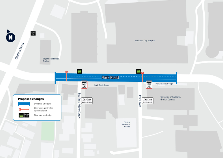
Park Rd Dynamic Lane
Travelling along Park Rd outside the hospital can be a challenge with people often queued up to access the hospital carpark. AT want to change that by removing the existing bus lane at certain times of the day.
Anyone travelling along Park Road near Auckland Hospital during the day likely knows the frustration: slow-moving traffic and long delays between 10am and 2pm.
This stretch of road becomes a major bottleneck for vehicles heading to the hospital, the Domain, or Newmarket – turning a short trip into a significant wait.
That’s why Auckland Transport (AT) is proposing some improvements to Park Road that we believe will ease the ongoing gridlock along this vital route.
AT’s Chris Martin, General Manager of Road Network Operations, says Park Road must be optimised for better use.
“Park Road moves 13,500 people by car every weekday, and another 14,300 people by bus.
“During the day, a short journey along Park Road that should take only 30 seconds from the Grafton Road intersection to just past the traffic lights and outside the hospital entrance can take up to ten minutes.
“We’re even seeing some frustrated motorists resorting to unsafe driving behaviours, by driving on the wrong side of the road and into oncoming traffic.
“Our proposal aims to make the most of Park Road by using dynamic lane technology, and we want Aucklanders to have their say on how we go about this too,” he says.
What is AT proposing for Park Road to clear this congestion and make it safer?
- A new dynamic lane layout between Grafton Road and the entrance to Auckland Hospital, which would operate Monday to Friday between 10am and 2pm.
- Electronic LED road markers on all three lanes between Grafton Road and the hospital entrance on Park Road.
- Lights installed on two overhead gantries to control lane signs. There would be a green light when the bus lane is active, a green arrow (indicating which lane you can drive in), and a red cross (indicating where you cannot drive).
- Dynamic bus lane signs on the side of the road that electronically indicate when the bus lane is active, and not in use.
- Digital message signs for motorists turning onto Park Road from Seafield View Road and Park Avenue.
- Digital messaging sign indicating parking availability for the hospital car park on Grafton Road.
At first you might think that this might mean there’d be a tidal bus lane, so at least buses can bypass traffic, which could be quite useful in the afternoon peak. That would make sense but it’s not what’s happening here. Instead they’re removing the existing bus lane during the interpeak period to effectively create a lane for cars queuing up – with the consultation page confirming:
For these four hours (10am – 2pm) on weekdays, buses and cyclists will no longer have a dedicated lane heading towards the city for 200m in the dynamic lane zone.
Essentially, “in response to impatient drivers doing illegal dangerous things like driving on the wrong side of the road, we’re gonna make it legal to do that for short prescribed stretches of the day”.
Consultation is open till 15 December.
Newmarket
AT are proposing a raft of changes to parking in and around Newmarket, including removing some.
Newmarket is one of Auckland’s busiest retail, commercial and residential areas, and demand for parking in the area is booming as more people live, work and visit.
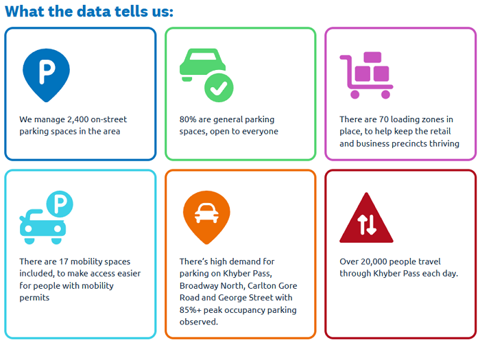
AT’s Andrew McGill, Group Manager of Transport Network, Planning & Policy, says there are about 6,000 parking spaces available in Newmarket, including parking in the Westfield Mall.
“Once you take out the 3,000 parking spaces from the mall, that leaves around 3,000 spaces available in the surrounding streets that are working hard to service the rest of Newmarket and Epsom North.
“AT is taking a neighbourhood-level look at parking and kerbside space to ensure that all of the incremental changes that have happened over time make sense today, and to make sure that they are fit for purpose for the future.
“We’re seeking your feedback on how we can better manage parking and kerbside space in Newmarket, improve safety, and ease traffic congestion,” Andrew McGill says.
So, what does AT propose to change in Newmarket
- Simplify existing paid parking zones and merge all paid parking areas into one zone for consistent pricing and operating hours across the week.
- The introduction of a two-hour time limit for parking in some streets to improve turnover. These changes would be permanent and across all seven days of the week and support access to Auckland Grammar School and Allevia Hospital in Epsom.
- Clearer parking rules to make it easier for people to understand where they can and can’t park.
- Widening the footpath along Broadway (from Remuera Road to Khyber Pass) in stages over the next 5 plus years. This will improve the experience for shoppers and visitors (making these busy footpaths less crowded) and create more room for street improvements and foot traffic.
- Improving parking access with new loading zones and clearly marked pick-up and drop-off areas.
A bigger, brighter, and bolder Broadway
The jewel in Newmarket’s crown, Broadway is set for some big changes that will make it more welcoming.
“We want to make Broadway easier and safer to walk around in, to support local businesses,” says Andrew McGill.
“We’re proposing thoughtful changes that will include widening the footpath to help foster a people-friendly environment that will make Broadway more accessible and easier to navigate.
“We’re also proposing a safe and accessible pedestrian link between the footpath and the entrance to Maungawhau/Mt Eden, and to widen the footpaths of several key residential streets in the area to improve foot traffic,” he says.
Taking a neighbourhood level view of parking is good and it’s especially pleasing to see the plans include making Broadway more pedestrian friendly by extending the footpaths by replacing existing paid parking. It’s also great that it appears to have the support of the Newmarket Business Association.
What concerns me though is that this appears to be looking at parking in isolation. Broadway is an essential corridor for both public transport (with six frequent routes using it) and cycling and neither have any dedicated space though the heart of Newmarket and this proposal won’t change that.
Are there any plans for additional cycle or scooter infrastructure beyond parking?
No, there are no plans for additional bicycle or scooter infrastructure beyond parking as part of this project.Are there any additional plans for Broadway and Khyber Pass Roads?
We are looking at how we move traffic through Broadway and Khyber Pass Road and we will come back to you early in the new year to get your feedback on the proposed changes.
The consultation is open till 1 December.
Ponsonby
AT are taking a similar approach to Ponsonby – though there is no footpath widening proposed.
Auckland Transport (AT) wants to introduce several parking changes for the Ponsonby area to meet high demand for on-street parking during the day and evening.
“Around 20,000 vehicles travel along Ponsonby Road every day and many drivers are also looking to park on the road, or as close to it as possible, including during the evening,” says AT’s Andrew McGill, Group Manager of Transport Network, Planning & Policy.
“There are more than 60 businesses along Ponsonby Road that are open in the evening too, and I’m sure their owners would appreciate more parking spaces for their customers.
“Ponsonby’s narrow residential streets are also very popular parking locations, but this popularity can create problems for local residents who want to park close to their homes, many of which don’t have off street parking.
“We need to manage many competing demands for limited road space and we’re seeking your feedback on how we can better manage parking, improve safety, and support access while staying true to Ponsonby’s unique identity,” he says.
What are the main changes being proposed for Ponsonby?
- Introduce some paid parking on streets near Ponsonby Road to improve parking turnover and improve access to local businesses. Costs will remain the same for the area at $2.50 an hour for the first two hours.
- Introduce evening paid parking to ensure everyone can enjoy Ponsonby’s popular nightlife. We’re planning to extend paid parking from 6pm to 9pm on Thursdays to Saturdays in busy streets within the central part of Ponsonby.
- Extend the Resident Parking Zone (RPZ) to include Kelmarna Avenue and Buller Street, to prevent commuter parking from limiting access for residents.

Again the parking proposals themselves seem okay, the issue is that it’s largely only parking that’s being looked at. Ponsonby Rd is used by multiple different bus routes and is often a source of delays due to the lack of priority. The only proposal to improve bus travel times is adding a clearway on a short (27m) section of College Hill at peak times.
Are these proposals being supported with changes to public transport services or routes in the area?
Yes, we have a couple or proposals to add some bus stops for better connectivity to North Shore.
Are there any plans for additional bicycle or scooter infrastructure beyond parking?
No, there are no plans for additional bicycle or scooter infrastructure beyond parking as part of this project.
Like with Newmarket, the consultation is open till 1 December.
AT also have a proposal for managing parking along Gt North Rd and it’s side streets between Grey Lynn and Ponsonby Rd

Consultation on this is open till 30 November.
Albany
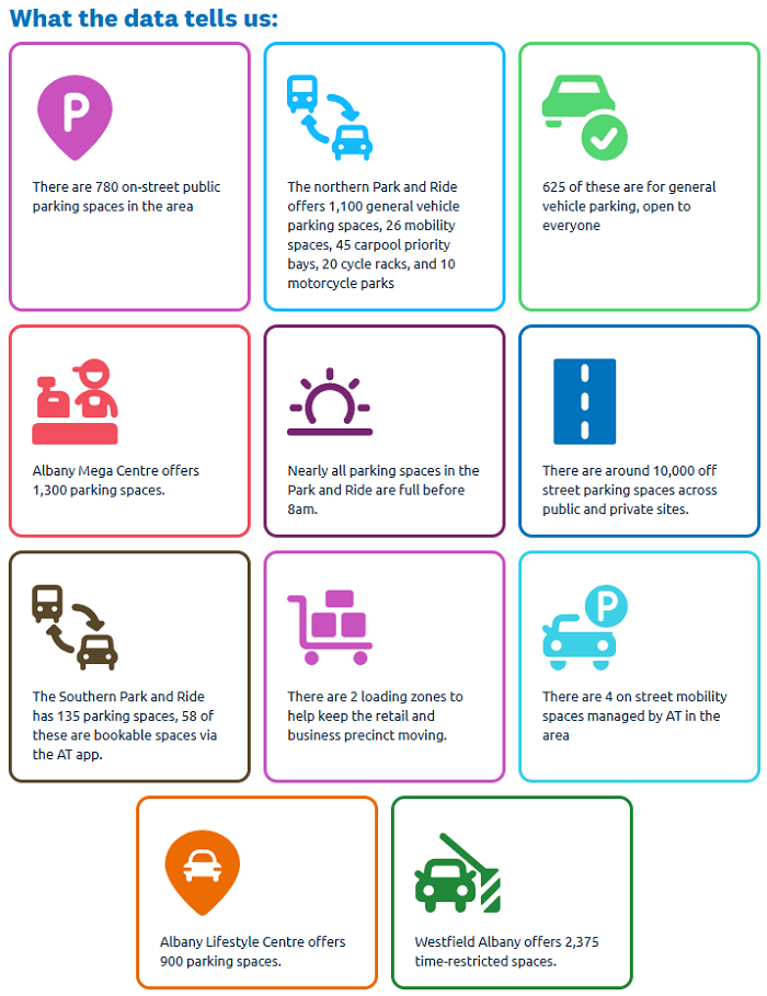
Albany is another parking consultation but this time much of the focus is on the park & ride. Earlier this year AT started a trial of being able to pre-book a space in a small section of one of the Albany park & ride facilities.
 AT say it’s been a success and they plan to expand it along with a few other tweaks to parking in the area.
Parking demand is growing in Albany as sites are redeveloped, and more people visit or work in the area, or use the Park and Ride to access Northern Express bus services from Albany Station.
Following a successful trial, Auckland Transport (AT) is proposing to increase the number of bookable spaces at Albany’s Park and Ride from 5% to around 10% of total capacity, among other parking changes in the area.
AT’s Andrew McGill, Group Manager of Transport, Network, Planning and Policy, says Albany Park and Ride offers 1,235 spaces across two sites.
“We recently completed a pilot of 55 bookable Park and Ride spaces in Albany on our AT Park app, and it proved very successful,” Mr McGill says.
“During the pilot, we found that most people who use the bookable spaces appreciate being able to park after 8am.
“We now want to double the number of bookable spaces available because nearly all parking spaces in the Park and Ride are full before 8am, and parking overflows into nearby streets.”
What the bookable space trial and users told us
- “Having this facility available is a life changer. Less stress in the morning.”
- “They provide wonderful peace of mind for parking at the bus station later in the day.”
- “It is a game changer for us with school drop offs when both partners work in the city.”
- 73% are repeat bookers with 44% booking a space more than 10 times
- 74% of users arrive after 8am
- 82% of respondents live outside of the Upper Harbour Local Board area
- 63% of users found out about bookable spaces via our posters at the bus station
- The area is generally full Monday to Thursday
Parking in Albany needs to move with the times
“AT is proposing to expand bookable spaces in the southern park and ride site as it is regularly full, while we will keep the northern site first-come, first-served,” Andrew McGill says.
“Not many people live near Albany Bus Station, so getting to the station relies on taking a local bus, cycling, being dropped off, or driving.
“People are parking in residential streets without parking controls, impacting these streets, so we need to improve signage to clarify the parking rules and encourage compliant parking.”
A few other interesting comments are on the consultation page itself about the Park and Ride
More bookable parking spaces
We plan to increase the number of bookable spaces from 5% to around 10% of total capacity.
- We plan to reserve the Southern Park and Ride for bookable spaces to meet growing demand.
- At the Northern Park and Ride, we’ll introduce bookable spaces near the busway station if we see the southern site regularly full, while keeping free parking further north.
Fair use for public transport
To make sure the Park and Ride is used by people catching the bus, we’re exploring:
- Barrier arms or licence plate recognition.
- Time limits to prevent long-term parking by nearby residents or businesses.
- Requiring users to tag into the carpark and then onto the bus.
Like with Newmarket and Ponsonby, the consultation is open till 1 December.
Manukau
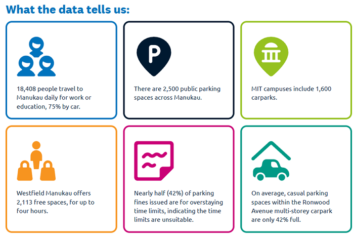
AT also has a consultation for Manukau, again primarily parking focused.
What we’re addressing
- On-street parking is very popular. Some streets see very high demand for parking, such as Clist Crescent, Osterley Way, Tuaiwi Street, Gladding Place and Lakewood Court.
- There are competing demands for parking between visitors, students, commuters and residents.
- Damage to public assets is being caused by berm parking on Lakewood Court, Cavendish Drive, Bakerfield Place, Tuaiwi Street and Horoto Street.
- There are inconsistent and confusing parking restrictions in central Manukau.
- There is a lack of safe pedestrian crossings on arterial roads like Cavendish Drive.

Like with the others above, the consultation is open till 1 December.
This post, like all our work, is brought to you by the Greater Auckland crew and made possible by generous donations from our readers and fans. If you’d like to support our work, you can join our circle of supporters here, or support us on Substack.

 Processing...
“Broadway is an essential corridor for both public transport (with six frequent routes using it) and cycling and neither have any dedicated space though the heart of Newmarket and this proposal won’t change that.”
Broadway is major chokepoint at peak times for these six frequent bus routes. Catching the 30 Bus from the Civic in Queen Street to Newmarket can take well over 30 – 45 minutes. While Newmarket to Onehunga can take only 20 minutes due to T3 bus lanes. Although congestion at Royal Oak Roundabout can add more travel time.
Need more bus lanes AT to improve public transport in the city!
“Catching the 30 Bus from the Civic in Queen Street to Newmarket can take well over 30 – 45 minutes. ”
Indeed, although next year you will do that journey from the new Te Waihorotiu CRL station to Newmarket in sub 10 minutes.
Same old car centric, vanilla, BAU rubbish which is the reason we alrady have all these issues.
Auckland, the place where bold thinking goes to die.
Broadway is the worst combination of trying to appease private vehicles while maintaining some sort of functionality for pedestrians (and nothing for buses or cycles/scooters). It works for nobody; drivers and buses have like 6 sets of traffic lights to navigate, peds are crammed on to footpaths, no bike lanes and no bus lanes for the thousands of people who move through on buses every day.
AT have also just published this consultation for a change to Green Lane West. https://haveyoursay.at.govt.nz/better-journeys-on-green-lane-west
Hi Jon. Thanks for adding that, looks pretty suboptimal though, 50kph traffic and no separation? I know currently is horrendous.
Seems like the ideal solution would be to jump the wall on the southern side for a lovely greenway shared path, surely the Parks Board could see a way to do without harming the park’s values and quality? Some tree shaping likely necessary…
That would allow space for at least Timtam protection on north-side bike lane?
I’ll eat my hat if the Cornwall Park Trust collaborates with anyone except their elitest peers.
For Park Rd AT should work with the hospital to reverse the direction of the circulation of traffic inside the hospital precinct to get the main entry point on Grafton road an exit onto Park Rd. If they introduced the dynamic lane on Park Road we could have a bus lane in the peak direction.
I’m 95% sure AT have suggested this to the hospital before. It was to essentially get the queing traffic inside the hospital grounds. I’m also very sure the hospital weren’t keen on this idea.
I consulted (professionally, as a traffic expert) to the hospital on this a decade or so ago. They had some grand plans, some sensible, some not – but in their defence, like with any large infrastructure site, changes come with a lot of costs. The site is quite steep on the north and west, and the car parking buildings are in the southeast, and there are a lot of in-use structures in the way, with winding narrow private roads (more lanes in some cases than roads) to connect them. Making that work effectively would of course be possible. But you’re talking *major* money to change the vehicular main entrance. When did the health sector last have that amount of money to invest?
AT have been through several rounds of trying to improve the Grafton area, especially for buses. Any change get caught up in wailing hysetria around oh my god why are you punishing people visiting sick relatives and you can’t catch a bus to the emergency department with a broken leg etc.
Any change except removing a bus lane to put in tidal traffic flow for cars that is…
The Park Rd proposal is so backwards there should be an enquiry into how it even got past first base. And whether there were politicians meddling, or if it was entirely AT’s brain fart.
100%. They say they support mode shirt, vision zero and we’re in a climate crisis, then every proposal is about car parking and denying public transport and cycling any more space.
My solution for Park Rd is to make it one way circulatory for cars. Leave as two way for buses and ambulances. The clockwise circulation of their parking building is the core issue here and pretty unsolvable unless we give up part of the Domain to cars – NO.
Instead make Park Rd one way to cars from the Grafton Bridge end through to Carlton Gore Road. This means to enter the carpark cars must come form the Bridge direction and it eliminates the queue (and the light phase) for cars coming from Carlton Gore Rd.
Turning Park Rd from Grafton Rd to the Hospital entrance into a three lane road, Queued cars, Bus/cycle to Newmarket, Bus/cycle from Newmarket.
Park Ave & Seafield View Ave become right turn only. Domain Drive North only entry is via left turn from Park Rd. Carpark exit remains left turn only.
Bus stops remain as is or possibly move the west side one back around opposite the parking building.
This would require some adjustment to Carlton Gore Rd from Park Rd to Grafton Rd. and some allowance for queuing on Grrafton Rd above and below the Park Rd intersection.
This is a system that runs the same rules 24×7 and doesn’t require massive Capex and Opex in light based traffic control systems.
While I don’t dislike your idea of one-waying for general traffic – in fact it has some interesting pros – I do have to say your last sentence is a bit strange. Whether you are agree with it as a good idea or not, dynamic lanes are a super-low CAPEX *and* OPEX option compared to the usual Auckland way of doing things, which would be either taking out the footpaths or some buildings, and then adding a lane.
Spend 100 million on a Park Road flyover so we can move the problem elsewhere
Amanin, i think making this area a circulatory would only require some signage, road furniture and traffic light reprogramming. There after no opex costs other than any other city roads, because its a passive system. The AT proposal is an active system and requires overhead lighting structures be installed, plus mountains of signage. Power costs to run the lights plus people watching it to ensure the switcheroo happens properly twice per day etc etc.
Guiding thought: “Most complexity is unnecessary, but we manage it instead of removing it because deletion requires courage that addition doesn’t.”
With exceptions for ambulances, presumably… can just use bus lanes, right?
Manukau missed the berm parking and plaza parking at Hayman Park.
People are either unaware of or unwilling to use the free parking at Amersham Way car park, just across Davies Avenue.
Peak South Auckland to have MPVs and Utes maneuvering and plopping over the playground entrance and desire line from the crossing, no enforcement to be seen.
It’s bollard time, baby!
I just submitted feedback on the same issue – hope others do too. It’s pretty crazy with all the kids around.
Do the Newmarket footpaths really need expanding? Never seen a huge issue there and perhaps that space could be set aside for bike/scooter lanes?
And in any other developed world city, Broadway would have had dedicated buslanes about 10yrs ago.
If you take out the two lanes used for 20-30 car parks between Remuera Road and Khyber Pass, there would be plenty if space for wider footpaths, street trees and cycle lanes.
I’ve been wondering what happens if AT makes a decision on the above in early 2026, then when RCA becomes Auckland Council some of these projects may be changed/withdrawn? Or is there already some mitigation plan in place?
Only if AC decides to a “This is our GPS now, punks! We’re stopping all your projects!” government switcheroo style change.
And since AC and AT technically (not always in reality) are already under the same overall rule, I would expect most, maybe nearly all, projects to proceed as planned (though not necessarily without hitches as the new structures bed in and Councillors, for better or worse, start making the actual decisions rather than just pointing into a general direction and then shrugging or fuming when things don’t happen the way they want).
I guess my worry is that as things bed in Councilors/Mayor will make some pointless/non sensical changes just to assert their new authority and show AT isn’t in charge anymore.
Have long thought a modal filter on the Broadway end of Remmers road would go a long way to fixing Newmarket. So only buses, people and bikes/scoots between Nuffield and Broadway, in both directions. Gen traffic can go round, esp as so much is aiming for the vast carparks at the mall, this traffic is befouling buses and gen traffic on Broadway. Simplify the signals all along there.
Yes.
It should have been one of many automatic responses to the traffic flow changes that happened when the Waterview Connection was built, if not before.
General traffic can go around.
Yeah people are only going through broadway currently because they enjoy sitting in traffic for half an hour!
Hey Bernard, look up, there’s a massive bypass in the sky above Newmarket, has been there for decades.
We have a very bad habit of building super expensive bypasses, but not taking place quality dividend as well.
A key value of bypassing is to enable the place previously burden by through traffic to be freed from that pain, and be able to rebuild its place qualities again, to become attractive to be in, once more. To thrive, not merely be a pipe to elsewhere.
Yes – trial this for a Newmarket event, show the success.
There are alternative ways around Newmarket if you’re only there to pass through.
Yes, bit like I suggested in my two part posts, except on Broadway.
https://www.greaterauckland.org.nz/2024/06/05/newmarket-a-better-broadway-part-one-of-two/
General traffic can go around.
Yeah people are only going through broadway currently because they enjoy sitting in traffic for half an hour!
“moving traffic and long delays between 10am and 2pm” is oddly specific.
And it is quite telling that no such consideration is given to long delays for bus passengers.
I had to be in Grafton Hospital once at 8:30am (because taking care of children is apparently so niche we cannot afford it at the hospital on Smales Farm). If you do that by car, you queue up on Onewa Road, which I timed to be about 45 minutes, and then you can drive over the harbour bridge and to Grafton. That’s about an hour. By bus on the other hand, Onewa Road is fast because it has a transit lane, but crossing the city centre is so slow that driving a car still comes out faster. And the return trip is much faster.
So, say, at noon I could queue up outside that parking lot for well over half an hour and still be much faster than taking the bus. But wait, you never have to queue for parking at your own house, so even people who have to queue up over there for an ENTIRE hour will still come out faster overall. So queues we will get.
So improving public transport would help, (and the proposal is NOT helping), but also, hospitals care seems excessively centralized over here. I can kind of understand this for specialists, but for some basic check for your kid you really should be able to go to any hospital.
cars are getting bigger and smaller, no consultation on how manage monster trucks (BYD shark) and micro cars (BYD Atto1). Micromobility is clearly not a topic of conversation or consultation.
Bookable park and ride ? – can i just put in a permanent reservation in case i need to use it ? Feels a bit like “lexus lanes” where if you have the disposables you can travel at any time and never have to mix with the rif-raf looking for a park.
Maybe the solution is to get busses servicing the park-n-rides as they will never be big enough. Surely there are tons of solutions tested overseas, im thinking as cities populations decrease, this must be less of a problem ?
I’ve reminded of Phil Goff telling AT to back right off when they put forward a proposal to limit parking on Aucklands Arterial’s. Then and there it was made clear that AT’s transport expertise was very 2nd to political feels, as were non clogged arteries. Parking rules define how many cars we want to accommodate in our cities, but in none of the consultation has it mentioned what the strategy is – more or less ? Just “better”.