The City Rail Link already proving a success, and we also know from many other projects, from rail to cycleways, that early bursts of growth aren’t a one-time thing, often taking many years for potential uptake to be fully realised.
There’s currently still a lot of capacity in the network, with trains nowhere near packed out; and Auckland Transport plans to increase services to 8 trains per hour per direction soon. Even so, over time the increased usage means we will need to further increase services to help accommodate that growth. More services to the west will put even greater pressure on the need to address the level crossings along the Western Line.
Auckland Transport has been starting to look at options for removing level crossings in the West – though frankly, this should have been started and sorted years ago. It undertook a high-level consultation earlier this year. Now, they’re starting to consult on more detailed options for each crossing, starting with the Inner West.
A guest post from Auckland Transport on the topic a few weeks ago foreshadowed that there would be options for each – so let’s now take a closer look at what’s proposed.
George St
George St is a steep zigzag through a light industrial/ commercial area that links Dominion Road to New North Road. Closing the road crossing of the railway line has long seemed the easiest decision of any of the crossings on the Western Line – and that’s exactly what’s being proposed.
Vehicles looking to get from Dominion Rd to New North Rd (or vice versa) would need to go a different way, most likely via Onslow and Sandringham Road.
That leaves the question of whether there would still be a crossing for pedestrians and people on bikes, and Auckand Transport has come up with four options.
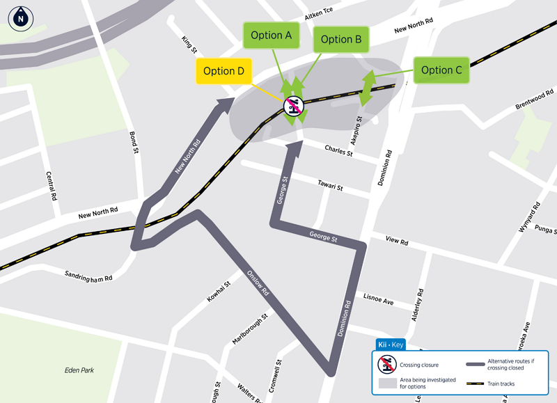 The fastest, easiest and cheapest move (Option D) would be to just close the crossing to everyone. Auckland Transport says there are “generally low numbers” of people using this crossing by any mode, also noting that this part of the line also carries the most train passengers. So purely by the numbers, trains outrank all other modes – and closing the crossing entirely looks like a valid option.
That said, this area will likely be home to more residential development in future, so there will be higher numbers of people looking to access shops, transport and other local amenities.
And the alternative walking/ biking/ scooting routes aren’t great, whether you go the long way round via Onslow (with a shortcut option of the steep steps down Monkey Hill) or the “short” but much bleaker way, via the Dominion/ New North flyover/ flyunder (which has intermittent protected bike lanes, at least).
Option A and Option B would keep a pedestrian/bike crossing at George St, via either a bridge (A) or an underpass (B). These are expected to be the second and first most expensive options, respectively. Auckland Transport notes an underpass would have a “slightly smaller ‘footprint’ than the bridge option, but more complex construction”, and that both would take around 12 to 18 months to construct.
Perhaps the most interesting option here is Option C: a pedestrian bridge from Akepiro St to New North Rd. The end of Akepiro is already above the rail electrification wires, making for a simpler and cheaper build than the George St options.
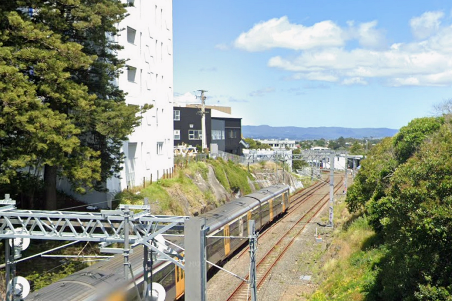
Akepiro St is just on the other side of the Daisy apartment development and already sits above the wires
The main challenge with Options A, B and C is that the real long-term solution here is removing the Dominion Rd interchange, returning it to a normal at-grade intersection. Not only would this improve movement options for all modes (potentially including light rail!) it would also free up a bunch of land in an area ripe for redevelopment.
So perhaps the best option is Option D: close the crossing for now, and look to progress the flyover removal as soon as possible? What do readers think?
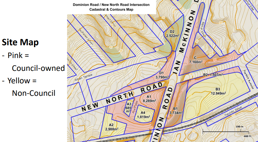
Removing the flyover would improve movement options and there is a significant amount of council-owned land surrounding the interchange that could be redeveloped
Morningside Dr
Morningside is a much busier crossing for all modes, which also provides access to the train station and is used by the 22N and 22R services which help provide a frequent connection from the train station to the St Lukes mall. Auckland Transport has looked at a number of options here, including realigning the rail line above or below the road – but doing that is likely to be both extremely costly and disruptive. Instead they’ve come up with three options.
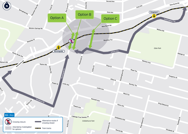
Option A would close the road crossing, and only have a pedestrian bridge to provide station access
Option B would build a road overbridge at the current crossing location, which would also provide access for people down to the station. A big problem here is that to get the road high enough to clear the wires, New North Rd would also need to be raised. That adds to the cost and would likely have impacts on the neighbouring properties.
Moreover, the existing crossing would likely need to be closed for a large part of the construction period. Road traffic would be forced to find an alternative – and by the time the bridge was complete, it’s likely that traffic would have adapted. Therefore there doesn’t seem to be any real benefit for Option B over Option A.
Option C is the left-field option. This would see a bridge built from about the intersection of New North Road and Western Springs Road, across the tracks and down to Rossmay Tce. This does have some additional property impacts but has an added advantage over Option B, in that it could be built while the existing crossing is left open.
This option also assumes a pedestrian bridge would still be built for direct station access around the Morningside Drive area. It feels to me that Option C is likely the one that will end up being chosen here.
Asquith Ave / Rossgrove Tce / Baldwin Ave
Because of the close proximity of these crossings, Auckland Transport has grouped them all together for solving. The urgent need to address safety here has been highlighted by the recent tragedy at the Rossgrove crossing.
Auckland Transport has had a lot of feedback on these crossings, from residents and locals keen to maintain connections across the tracks.
They also note that a good chunk of the drivers using Asquith Ave are not locals, but people travelling longer distances and using this route as a rat-run, which isn’t the kind of movement AT should be looking to support and encourage here.
Auckland Transport has come up with five options, and all five include a pedestrian connection to the station from Baldwin Ave (they don’t specify whether this would also land at Margaret Ave on the other side of the rail line, but that would be the logical inference).
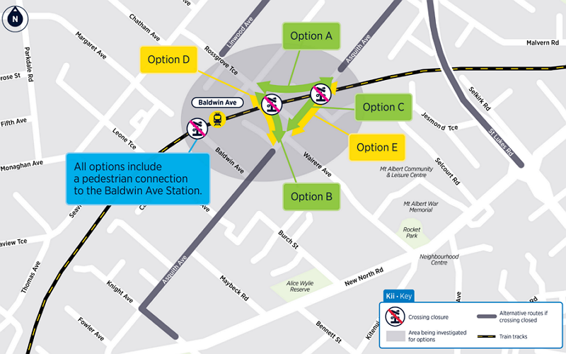
Option A is the cheapest option to deliver, and also the fastest, an estimated 12-18 months. It would close both road crossings, but build a new local access road along the north side of the tracks, reconnecting Rossgrove Tce to Asquith Ave. This would still provide easy options for people making longer-distance trips out of the area.
A number of properties would be needed to build this option, but this would also open up some redevelopment opportunities for the land that’s not needed for the road.
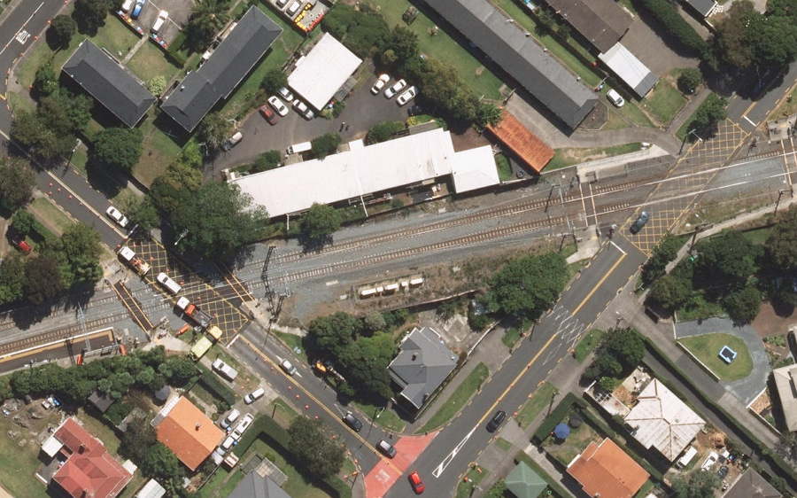
Note that one safety anomaly here is that the driveway for the units at 84 Asquith (top right of the image) connects to the road inside the level crossing barrier arms.
Option B and Option C both involve building a bridge. In Option B, the bridge would connect Rossgrove to Asquith, while Option C would keep Asquith connected. (AT says it would be one or the other, not both.) Given the road layouts and topography of the area, these options would be much more complex and costly, requiring a large construction footprint, resulting in a bigger structure, and taking two to three years to complete.
Auckland Transport has also highlighted Options D and E for consideration. These are road underpasses, along the same routes as B and C, with more significant trade-offs to consider. They would be even more costly to build and take longer, plus would have even greater impacts on the rail line.
To me, Option A easily looks like the best solution here.
Woodward Rd
The last of the Inner West crossings, and one of the busiest level crossings on the line: Auckland Transport has only two options for Woodward Rd.
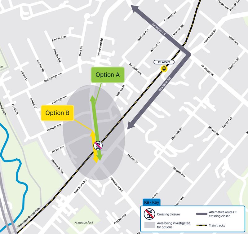
Option B, the cheapest and fastest, is to just close the crossing and build a pedestrian bridge only. Auckland Transport’s concern with this option is the 12,000 vehicles a day that currently cross the tracks here, which would instead have to shift to New North Rd and through the Mt Albert town centre.
Option A would build a road bridge across the tracks – this would not only cost more, but also requires either raising New North Rd and/or partially lowering the rail line, either of which would create a lot of construction disruption. Shifting the rail line might also impact other plans AT have to add a short section of additional track just west of this crossing to act as a way to turn-back future higher frequency services.
My guess is they’ll go with Option A here.
Consultation on each of these crossings is open till Monday 28 September, so jump in and provide feedback. Note the individual pages also outline what options are not being considered, and why.
Auckland Transport expects to consult on the options for the rest of the Western Line early next year.

 Processing...
For George Street, below is part of the feedback I gave during the initial consultation back in May. It’s a shame AT seem to have ignored this option completely, as you say.
“Also for the George Street level crossing in Kingsland it would be best if AT/Council could look holistically at the wider road network over a narrow focus on just this crossing in isolation. I say this as it seems a lot of the traffic using this crossing is doing so getting to/from New North Road and Dominion Road as the nearby flyover junction doesn’t allow for all movements. It would be preferable to close the George Street level crossing and at the same time demolish the nearby New North Road/Dominion Road underpass and flyover junction and replace it with a standard at grade light controlled junction. This would allow for traffic movements in all directions at this junction and so remove the need for a lot of the traffic to use the George Street crossing, which could then be closed.
This would also have the added benefit of allowing for new residential/commercial development around the removed flyover junction.”
I imagine it is like the rest of Dominion Road, waiting to see what happens with LR.
Are Labour even campaigning on LR this time? I haven’t heard a peep.
I wish National would just build a busway down Dominion Road and kill off LR for good. Not that I don’t want LR, but it will never happen and its preventing other options.
Where is Auckland Transport’s key foundational work behind this? That is, their over-arching traffic circulation and low traffic neighbourhood concept?