A clear game-changer for Auckland would be the earliest possible completion of the long-planned Rapid Transit Network. We have a growing and improving bunch of lines, on a long held and evolving plan, but as yet not enough of the whole to gain the great multiplying benefit of the network effect.
This is based on the assumption that the value of a region-wide, branded, highly visible full network would be considerably higher than the sum of its parts. It would be of more use to more people, across more of the city, at more times, leading to a significant uplift in efficient access across the city, well beyond the just the city centre. Therefore higher growth in ridership sooner.
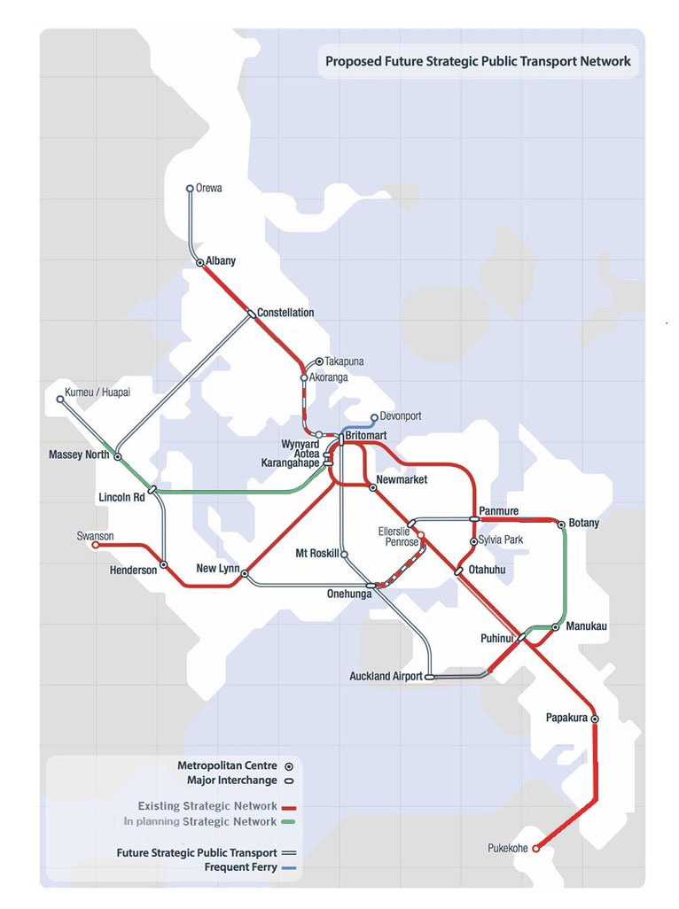
ATAP RTN progress by 2026
Very few across the city, in council, and in government probably disagree. But adding new rapid transit routes to an existing and spatially constrained city is very expensive and takes years and years. So how can we speed this up?
Here is the case for adopting a strategy to quickly complete all the missing branches of the RTN to a cheap and quick standard, not true rapid transit, but in the most cost effective way, as close as possible to it. This of course means buses on existing roads, on all the clear and green lines on the map above. With targeted investment – much more on frequency, span, connectivity, operational priority, and branding, much less on concrete and steel.
This is also a timely strategy as inflation in the construction sector has got so wild, and money is scarce, especially as central government is distracted by trying to fund overscaled roads at the expense of everything else. So we have to think. A form of shock treatment, a strategy to jump ahead, with value for money at its core.
To be clear this is a Pre-Rapid Transit strategy, with the aim of getting the full network up and running sooner, not just a proposal to dumb it down, or re-defining it away. Adding start-up lines to build the case for the real thing. Because by getting to the network effect sooner, the case for funding the real RTN will become clearer.
We already have a very good recent example with the NW start-up, where some really pretty tough in-motorway stations, plus a new frequent service pattern with good clear branding, has been met by massive uptake. Which has already worked as a proof-of-value in that route, and a full busway is now in design (but yet to be funded).

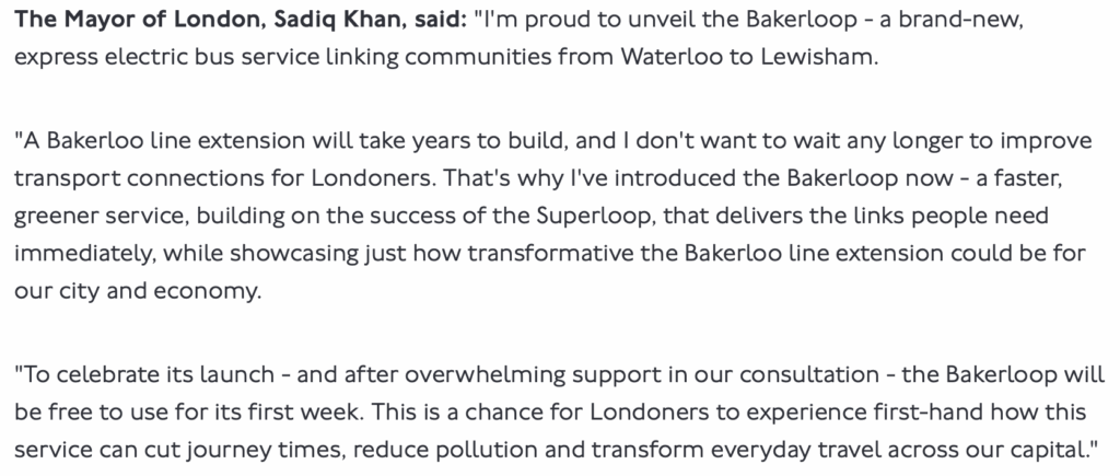
Here’s a great recent example from London, The Bakerloo Line has always stopped way too soon at its southern end. There’s a long held and obvious plan to extend it down the Old Kent Rd to Lewisham. But there are also many other great opportunities across London’s networks too, competing for limited funds, and even if begun today would take a decade to deliver.
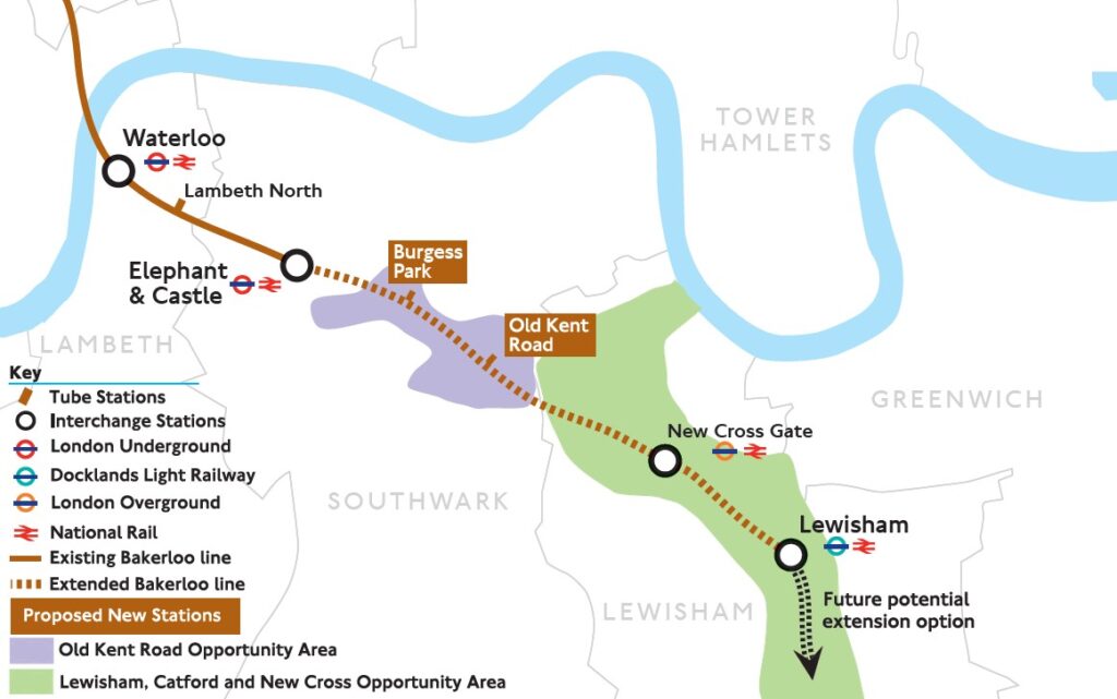
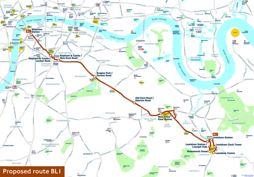
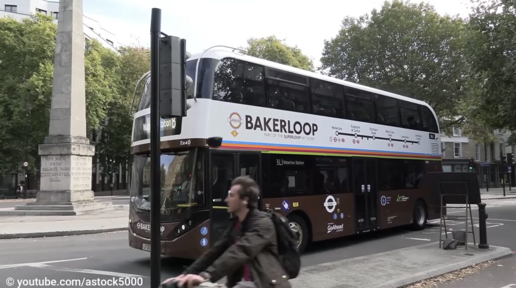
So while the Bakerloo Line extension is still definitely the plan, in the meantime TfL have launched the Bakerloop bus line on the streets above the proposed Tube line, with improved frequency, priority, fewer stops, and clear branding:
So is this viable on the key missing RTN routes in Auckland? The North-west already has a version, as there is over the Bridge to the Northern Busway, Airport to Botany, and the Upper Harbour, can surely be run in a similar way, with minor investments. But how about the deleted light rail route City Centre to Mangere (CC2M)? Well consultants MR Cagney have already looked at this and here’s their proposal:
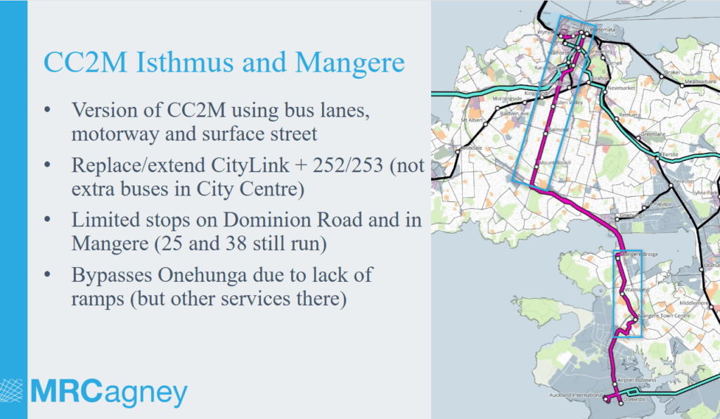
This looks pretty good to me, likely to operate as successfully and Wellington’s brilliant AX airport service. It would be subject to congestion on SH20 section unless bus lanes can be extended significantly. Is well complemented by more local services, though I disagree with deleting the City Link for it as that is a well used and highly legible (esp for visitors) local ‘walking accelerator’ and can not be replaced by a limited stops regional service- these are different markets.
What do you think? Clearly there are challenges and risks to this plan.
Perhaps they won’t be enough of an improvement on current services?
Alternatively perhaps they succeed so well they become an excuse to not invest further in true RT on these routes, so improving access and ridership to point, but locking it there?
And for the routes that enter the city centre, it will likely accelerate bus congestion, negatively impacting the city?
I look forward to your views below.

 Processing...
Looks logical to me. The northernmost bit, between Albany and Orewa, simply involves converting motorway lanes to bus lanes. They’re lanes that were additional to the old road and should have been bus lanes to begin with.
Complementary to this pre-rapid transit network is the rest of the bus network, which needs buses to be freed from traffic congestion, alongside safe cycling. Space constraints mean we need to focus on low traffic neighbourhood, modal filters and traffic circulation changes to achieve this, rather than trying to preserve traffic priority and squeeze in some bus lanes (which pits buses and bikes against each other).
Looks pretty good to me in some ways I would see it as a replacement for the sky bus who wants to go to the casino anyway. It will impact the rail bus link through Puhinui as well. But it will provide a better service for Dominion Road and Mangere residents.
This would be fantastic. I’m a big fan of the train, but the huge increase in travel times means I often end up reverting to Uber or Mevo instead.
Using public transport, you used to be able to get from:
– Albany to the airport in about 50 minutes (now it takes around two hours!), and
– Anywhere on Queen Street to the airport in about 40 minutes — now it’s roughly 75 minutes to reach Britomart, plus travel time to your final destination.
Side note: Thanks for your continued contribution and efforts to the city, Patrick. I really appreciate the time, effort, and personal investment that goes into running for public office — it’s a real loss not to have you on Council.
Looks good, but should include Onehunga! The Stage 1 EWL, Galway Link – announced this week should take pressure off the Onehunga interchange ramps and Onehunga Mall south of Neilson Street. Add a small bus only offramp on Wharangi/Princess street…
There are changes coming in Onehunga that could make a connection with bus and rail feasible. It needs to be included in evaluation.
Great suggestion, Patrick! To give this some context what would the following number comparison look like?
1. Daily ridership on the NEW parts of this plan
versus
2. Daily drivership on the MoreRONS suggestion from yesterday.
It may be necessary to pick a future date to validate the comparison, say 2030.
then
3. Compare the CAPEX dollars to get both outcomes in raw dollars and $perPAX.
Maybe we could post a hypothesis to disprove such as the ‘MoreRONS’ will be 100 times more expensive than than the ‘pre-rapid transit’ plan?
As someone in Māngere Bridge (so extremely biased) I am crying out for something like this.
It’s kinda funny, considering up until a month ago they were getting entirely rid of the 309X (but that seemed like an out of date ideological decision rather than something based on usage data).
I still see tourists get kinda mislead by Google Maps and end up at Māngere Bridge bus stops to try transfer to the city, so a single, well labelled and hopefully relatively express bus to the city from the airport is a great idea imo.
What seems to be missing is a more direct connection between North West and South/Airport or even Onehunga/Penrose area. Perhaps via Rosbank Road, Avondale and towards Onehunga.
Currently using PT on that route is simply not viable, as it forces transfers in the city centre, greatly adding to travel time. Lincoln road to the airport is over 2h on a bus/train. vs about 45mins in traffic on the motorway, 25mins off peak.
Could have a limited stops motorway express bus from Pt Chev to Manukau along SH20, stops off here and there on the way. If there was some bus lanes would help during congested times.
Patrick, I think Councillors of all stripes might support this suggestion for Mangere. No-one likes how the area has missed out on PT connection, and regardless of where they sit on the politicised light rail saga, this should appeal.
Have you thought through any details about the city end?
Lower Albert Street Interchange is the obvious city terminus.
Assuming plan to take NX1 through to Beach Rd is carried out, should be capacity for both the WX and this AX, I’m guessing.
So either via Queen, as shown above, or Upper Queen till Mayoral, then Albert…?
Additionally, you are absolutely right, CC2M was always much more about Mangere than the Airport. So ideas like a rail spur from Puhinui are no kind of substitute.
Ta. Sounds good.
I really think this is the sort of idea that the Auckland Councillors, now they going to be in charge of AT, could push through and claim some kudos for and use to justify the Governance change. As in “Hey, look what we’re done real quick, that AT couldn’t get done in a decade”.
The story would be all smoke, mirrors and image but that’s politics these days. More important is getting some Pre-Transit done!
Yes, indeed. Choose your councillors well.
Bit on the nose Mr plod!
Downtown is going to be messed up for a while, changing Fanshawe St then taking down the viaduct all the while building on the Downtown Car Park site. Early adoption Pre-RTN may need to keep away from that corner of town to start with.
Express City-Mangere via Do-minimum Road could be facilitated with a few small interventions for efficiency.
Any of these early service start-ups will need some local interchange stops to be developed for transfers. WX1 examples show these can be awkward, but possible.
Jago on the Bakerloop:
https://youtu.be/ROqW5WbScdY?si=Ior9mwDxFAYN6UPU
I do hope we start looking to using space reallocation on roads to provide for PT and walking and cycling. Seeing how far from the motorway the ground testing is being done looks like the NW busway will be a huge build, lots of houses and infrastructure being taken to widen the motorway.
Yeah. At every scale of project, there’s a better way of providing the amenity they’re after. Much cheaper, with traffic reduction effects.
Carrington Rd for example: traffic dropped after the Waterview Connection. They should’ve immediately reallocated lanes to cycling; with timed modal filters ensuring traffic volumes never rose so high again as to slow the buses. Still could implement this, and it would save over $100 m.
A2B… That’s one step up in the scale, but similar. None of those hundreds of purchased properties were required. One lane for traffic each way is sufficient, leaving room for proper cycle lanes and bus lanes.
In both cases, the traffic modelling was misinforming the decision. In all cases, in fact…
Yes I am very worried input the NW Busway plan, at this stage looks like a giant project that then feeds back into the same bottlenecks we have now. Would much prefer better bus priority on the motorway, using paint and signage, right now, than wait for construction. I am also unhappy about the flyover proposal at Te Atatu (which was shown at the consultation event, but not currently online anywhere)
Its always seemed logical to me to start with improved bus services, there is so much improvement possible.
However we were told it would create too many buses in the city centre and only light rail was possible…
The real problem is that if they implement this the business case for LR disappears overnight.
“The real problem is that if they implement this the business case for LR disappears overnight.” – which is why I’m surprised National haven’t done it already!
Yes good point, but I’m not sure that’ll be true, in fact I think these ‘pre-metros’ will in fact accelerate the case for both true RT and higher quality transit like LR.
Our evaluation practices are happier with extrapolations of existing ridership numbers than modelling new ones.
Existing ridership, including growth after investment, like we’ve seen with the WX1, is very confirming for technocrats and politicians alike. Plus existing users are voters!
Well, so many pushed back on light rail saying we could do the same thing or better with busses, now it’s time to actually follow through on that and actually do something! I’m assuming they actually believed that and were committed to the vision, not just creating barriers to change because that would be cynical.
There are bus lanes on either side of Mangere Bridge. Getting buses off and on the motorway to and from Mangere Bridge seems to work well each time I use the 38 bus. I support missing out Onehunga I have though about it many times prior to this and it always seems to difficult. One thing at present the link buses are electrics will they have the legs to run the whole route or would there need to be a transfer downtown. Maybe I haven’t read the article close enough. Is the intention to provide a one seat ride from Orewa to the airport.
The problem is the other way, from Mangere off the motorway to Onehunga is congested, then back on the motorway northbound is even worse. A huge diversion.
“central government is distracted by trying to fund overscaled roads at the expensive of everything else”
Expensive is a typo I think.
They’re used in Germany, the Netherlands, France and Italy, so yeah you do see them all over Europe.
I agree it is better focussing on the current frequent network instead of the rapid network. A lot of frequent lines already fill the gaps of the rapid network.
One problem is that there are not really good official transit maps for Auckland or they are hard to find. I have not seen an official frequent network map similar to this (https://imgur.com/EH43m3O), does there one exist?
Now the problem shifts to speeding up buses and improving the frequent network. Operating buses as trams would do the trick:
1. all door boarding in combination with articulated buses (faster and more capacity)
2. priority for buses at traffic lights and when re-entering traffic after a stop
3. increase frequency (less waiting time and more capacity)
4. bus lanes
5. station spacing
And even a subset of these improvements can speed up buses and make the service more attractive. If a corridor runs out of capacity you have already a business case to replace buses it with trams! And as long as there are no tunnels involved (!!!) the building of a tram line can happen pretty fast (~ 2 years) and be cost efficient.
Greetings from Austria
Would there be anyway to get it to pass by the hospital. I was thinking about the university but it might be asking to much.
the old Advanced Bus Rapid Transit study involved branching CC2M services, half via Dominion Road, half via Manukau Road, interlining again at Onehunga. Likely the latter service would use the Central Connector to get to Newmarket and therefore pass the hospital and Grafton train station
a fair few of NZ transit enthusiasts tout a light metro under/elevated over Manukau Road to get to Mangere & the Airport instead of a Sandringham/Dominion Road route, citing the greater density development allowed in the unitary plan zoning, so it wouldn’t be un-justifiable