It’s the last Friday of the school holidays. As you get ready for a busier week for transport next week, take a look through some of the things that caught our attention recently.
This Week in Greater Auckland
- On Wednesday Matt looked at the secrecy of mega-projects.
- On Thursday a guest post from Stephen Reynolds noted it was time to get off the gas.
This roundup, like all our work, is brought to you by the Greater Auckland crew and made possible by generous donations from our readers and fans. If you’d like to support our work, you can join our circle of supporters here, or support us on Substack.
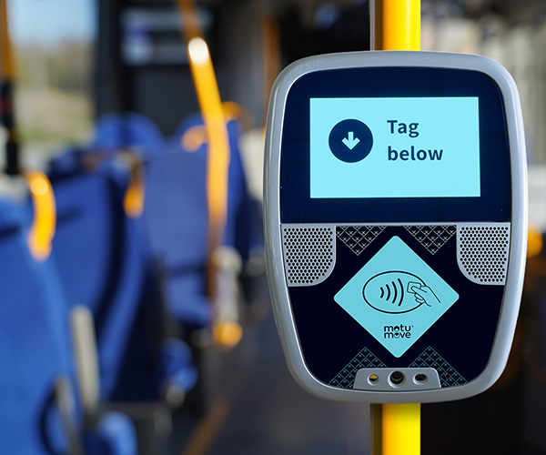
Will it ever be delivered
1news reports on the latest about the delayed roll-out of the national ticketing system.
Budgets earmarked for the majorly delayed national transit ticketing system, Motu Move, are “under pressure”, a critical review into the $1.4 billion project has found.
The review found a “very high likelihood of further significant delays” to the programme and an inability to deliver the full scope within the committed contract value, according to a heavily redacted version of the report
LEK Consulting’s 26-page report also exposed tensions with multinational provider Cubic, which is delivering the system, and local councils over the implementation of Motu Move.
But the review, which suggested the public transport project lacked enough public transport knowledge, concluded there was “no strong rationale” to halt the project.
The prospect of cost overruns would be another blow to the National Ticketing Solution (NTS), which has come under increased ministerial scrutiny in recent months.
…..
A key finding in the LEK report was that “the scope that NTS needs to deliver is not locked down and is evolving as the programme progresses”, with requirements becoming increasingly “obscure” since they were developed five years ago.
Governance problems were also called out, and it was suggested that knowledge about public transport and ticketing only existed in “pockets” within the programme team.
The Housing Section
The council’s chief economist has been out discussing housing a lot recently, this includes a good piece in The Post focusing a lot on the opportunity around Maungawhau (which itself is just a rehash of this council article but with likely more views))
Aucklanders’ preferences on where they live varies, but in general people trade off what they want against what they can afford.
If we look at land values as an expression of demand, that demand tends to be stronger in locations near services, jobs and transport – places such as Maungawhau/Mt Eden.
Since 2016, we have learned from the Unitary Plan that enabling more density creates development opportunities and expands housing choice – in both type and location. This gives more people the option to live closer to things they prefer, such as good transport links.
…..
Allowing more height makes room for more homes, so more people can live closer to rapid transit and the jobs it connects them to. With better access and shorter travel times, public transport becomes a more attractive option.
…..
Housing choice means having options across types, locations and price points. The Unitary Plan enables denser forms that use less land per dwelling, enabling more homes in many locations – and that supports affordability, too.
And in Interest.co.nz he’s looked at the most recent property valuations (originally from here)
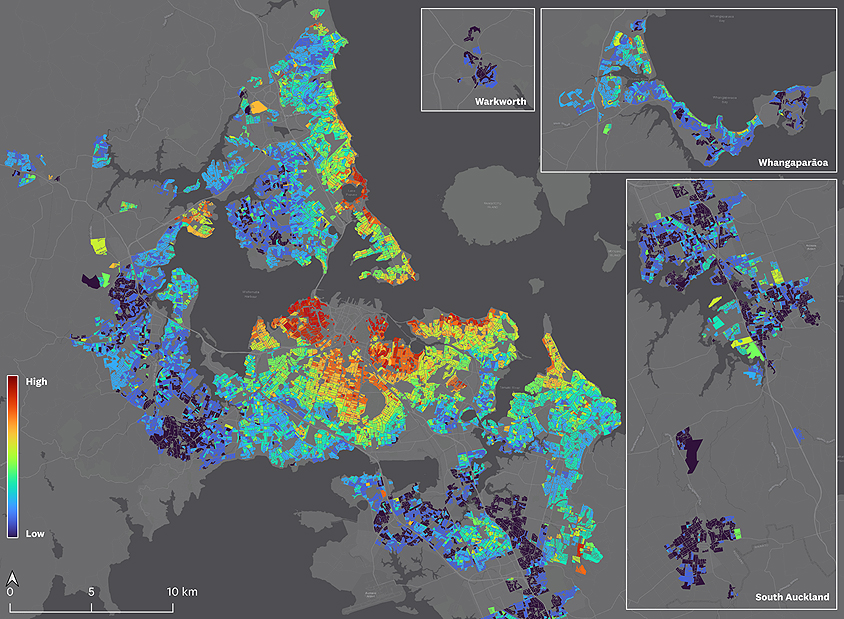
Where do people in Auckland want to live? Land values hold the answer. To better understand the demand for housing across locations, the Chief Economist Unit has developed a spatial model to analyse land values and uncover what drives them.
A new spatial demand model
Using 2024 property valuations, the model estimates land values per square metre to assess how location influences demand. It covers land zoned residential or business mixed use. Regression analysis identifies factors affecting land values. To isolate demand for location, the model adjusts for two key factors.
- Zoning policy — the value of land is partly driven by its development potential, with land zoned for more intensive use generally having higher value. The model controls for how zoning varies across locations to separate out this effect.
- Local characteristics —differences in land value due to neighbourhood-level factors, such as the built form, are controlled for at the meshblock level (small geographic units).
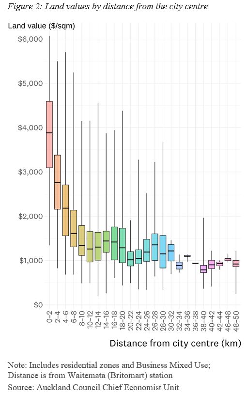
Another way to visualise demand is to plot land values by distance from the city centre. Figure 2 shows a box and whisker plot with 2km bands: the box show the middle 50% of values, the line marks the median, and the whiskers indicate the range. Land values tend to decline with distance – a common urban pattern – but with some variation at each distance that reflects the influence of other centres and natural amenities.
While Auckland has a network of centres offering jobs and services, the data suggests it is more monocentric (a dominant city centre in a hierarchy of centres) than polycentric (multiple centres, none dominant).
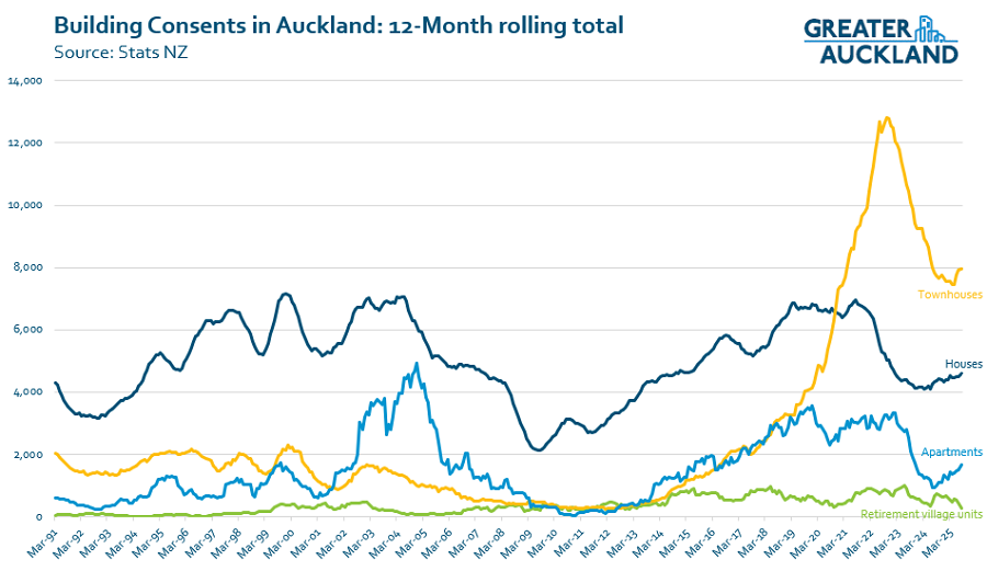
Speaking of housing, the latest building consent data to the end of August shows we’re starting to see a bit of recovery in consents again and while it’s still some way of where things were, we’re still a lot higher than prior to the Unitary Plan.

Malls vs the city
From Christchurch, a good reminder that cities aren’t just about the shops but the overall experience, and why it’s so important we focus on making our cities people friendly.
Shop vacancies and a fight for foot traffic.
It’s a battle facing some Christchurch malls as shoppers choose the central city “experience” over traditional retail therapy.
…..
Trending central city food spots, laneways, Riverside Market, Ballantynes and the picturesque Avon River were attracting people in droves, said Wilkinson, the managing director of First Retail Group.
While many malls, governed by older architecture, hadn’t been able to evolve and create a contemporary feel, Christchurch had been able to essentially “dream of a city centre and build it”, he said.
…..
Young consumers were a “big part“ of leading trends, sharing things with friends on social media – be it a cafe, restaurant or store.
…..
Malls and high streets needed “all the right ingredients” to succeed these days, Young said, including atmosphere, lighting, space, good customer service and quality stock.
And the retail experts agree central Christchurch has hit the nail on the head, and the post-quake struggle to attract people back is history.
“The Christchurch CBD is a great example of a high street type environment working really well” including “beautiful stores, great cafes, bars and restaurants … and Ballantynes being that anchor,” Young said.
Wilkinson said the CBD was just as much about catching up with friends at Riverside Market and The Terrace “or stocking up for provisions” – and less about buying consumer products “because those products are available through a lot more channels now”.

It’s not all AT’s fault
AT has it’s issues but this is a good example of how AT often get blamed even when the issue is not them.
Roadworks that were due to begin on Monday, reducing to one lane the only access road into a booming Auckland suburb, have been postponed just days before they were about to begin.
Scott Point residents were told that four months of work on Scott Rd would start this week, with traffic controlled by stop-go lights in both directions.
Locals feared it would severely affect daily travel to and from the fast-growing suburb near Hobsonville.
Communities had been advised through Facebook posts, a display board and leaflet drop.
At 2.48pm on Friday, Stuff received an email from contractor CCL outlining the planned works. But just 50 minutes later, Auckland Transport (AT) said the project would not go ahead as scheduled and may be delayed until other work is completed.
In reality, this is an issue common to greenfield areas undergoing large scale urbanisation where outcomes can be different developers with their own timelines. The works above are from one developer who need to deliver improvements to the road as part of consent conditions but it wouldn’t be such an issue if a different developer completed the connection between two sides of Joshua Carder Dr.
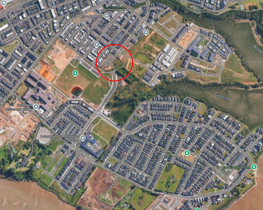 The missing connection between two sides of Joshua Carder Dr that would give residents an alternative option
AT also say that once that connection is built, they’ll run bus services through the area too.
Pete Moth, AT’s head of public transport services planning and development, said they hope to better serve Scott Point with a bus route.
“Once the Joshua Carder Drive connection is completed, AT will amend route 112 to serve Scott Point. We acknowledge the frustrations of Scott Point residents in not having access to a regular bus service,” Moth said.
“As soon as the private developer completes Joshua Carder Drive to a safe standard, we will implement a bus service as soon as we are able.”
Gather your own traffic data
Want changes to your street to make it safer but lack the evidence, this might just be for you.
Before sundown on a recent Wednesday, about 6,651 cars drove past Anna Mabrey’s house on St. Paul Street, slightly more than the previous week.
She’s not sitting by the window counting, though — a small, plastic box is.
The device, from a Belgian company called Telraam, analyzes passing movement and categorizes what it sees: cars, trucks, pedestrians, bicycles, etc. It counts each type and averages speeds.
Mabrey has been organizing her neighbors around ways to prevent aggressive driving and speeding ever since a driver hit her as she crossed the street just outside her house last year, leading to surgery and months of recovery.
…..
Communities like hers that request traffic-calming measures — things like speed bumps, automated cameras, and so on — generally must wait for costly traffic studies.
…..
Kris Vanherle has used just about every device available to him over his nearly two decades as a traffic engineer in Belgium: drones, pneumatic tubes, handheld counters. They can get pretty expensive, some requiring expertise to use.
So he developed his own device — one that presents raw data in a way that everyday people, not just traffic engineers, can understand.
“We want to foster a discussion between residents and the policymakers,” Vanherle said. “The data is out there. Anyone can check, anyone can verify … This serves one purpose: to build trust.”

Giving Cyclists a Green Wave
Hitting a green wave? It’s the best feeling, especially when you’re in a hurry,” says actor Samuel Traum, unlocking his bike by a Copenhagen intersection thronged by two-wheeled commuters. “The opposite, a red wave, is the worst.”
For those of us who do not live in cycle-friendly Copenhagen, the green wave that Traum describes is a system started by the city authorities 16 years ago: in order to encourage bike travel, they synchronised traffic lights on several key roads so that a rush-hour cyclist travelling at about 20km/h (12.4mph) could catch green lights all the way.
Green waves are now set to spread to 15 more routes after the municipality approved new cycling provisions in the budget this month.
“The idea is nice because usually the lights are set at the speed of the cars,” says Lars, a 33-year-old analyst cycling down Nørrebrogade, where the first pilot project began. “I wish it would be expanded.”
An interesting video on Broadway in New York and what is notable is the role of neighbourhood groups in it’s development
Have a great weekend.

 Processing...
Drove the South Western motorway at 3:30 yesterday, it was crawling. Before Waterview it was always fairly reasonable. So we spent all that money on Waterview and potentially ended up with a worse outcome.
It’s quite obvious to anyone who isn’t in the National Party that building a road only second harbour crossing will achieve the exact same outcome, or perhaps worse.
? Waterview was a decision made by The Helen Clark government. One that made and still makes sense.
A motorway to the airport and an Auckland bypass. Cant really fault them building it since the alternative would be to have all this traffic go through the cbd.
Why the Jacinda government failed to commence on lightrail to the airport, despite a large mandate, something that would have relieved the motorway is however something that still annoys me.
The point is that if you spend billions to fix bad traffic somewhere in Auckland, you just move the problem elsewhere.
The Western Ring Route was meant to be a quicker alternative for people going from Manukau to Albany. I suspect it is very rarely quicker as it induced demand and is now just as congested.
The only fix is PT, spending a cent on roads in Auckland is a wasted cent.
“The Western Ring Route was meant to be a quicker alternative for people going from Manukau to Albany.”
It was also argued during the consent process as lowering traffic on key Isthmus arterials, allowing those to be re-aligned for PT and active modes more. Of course then nothing ever happened before those volumes went back up by induced demand…
Ha, I took a call whilst in the Waterview tunnel Yesterday at 3.26pm. Drove from Hobsonville to Penrose via the Waterview tunnel (usually quicker than into town and onto SH1) and that trip was 32 minutes. Vehicle is tracked so numbers are real.
Guess you must be referring to the other direction ?
I drove from Manukau to Hillsborough. It wasn’t terrible but congested. The other direction looked awful, granted that was backed up from Manukau, may have been fine if you got off at Neilson.
The tunnel itself may have been fine, but all those extra cars end up on the 2 lane part towards Manukau. If they fix that and make it 3 lanes, then the bridge will be the problem. If they fix that and make it 6 lanes, then the tunnel will be the problem. More lanes will never fix it.
As to housing, there was a lot of crowing on Reddit about the new apartments in the Carrington development not selling and thus being marked for renting – something about how this proves that no-one really wants to live in inner-suburb density and we should go back to prioritising greenfield sprawl?
This is happening to all types of housing everywhere in Auckland. Something to do with lots of people leaving for Australia I imagine.
What puts me off buying an apartment is body corporate issues. It seems to me you have more control if you buy something with a bit of land on the title. Either stand alone or in a block of flats.
Is this something NZ is particularly bad at or is it a worldwide thing with regards to apartment ownership? (genuine question)
Not a problem for me as an apartment owner in the UK.
The leasehold is the bigger issue, especially if it’s not a new building, as it can be quite expensive to renew or makes it hard to sell, especially if you have a place covered in flammable stucco as is common in many tower blocks here.
What’s wrong with renting an apartment and leaving the body corp to someone else? Buying a house often just means buying a big debt. Buying an apartment to live in means debt plus body corp.
In my experience, it depends on who manages the body corporate.
While renting in Wellington, the body corporate changed to letting a property management company handle it.
That company arranged for the exterior painting of the entire complex.
But didn’t tell anyone that the painters would be entering the properties.
I came home one day to find the door to my house and my neighbors house wide open with no one around. We could have been comprehensively burgled.
My rental agency and the owners were horrified and very apologetic even though it wasn’t their fault. They hadn’t been told anything about the painting.
They requested an explanation and an apology, it never happened.
I ended up having to leave notes on my door telling the painters they could not access the property without my permission and attendance. They thought I was being difficult.
Council/AT should be designating key collector roads and bus routes in greenfield developments to avoid a single developer holding to ransom tranpsort outcomes for a whole neighbourhood. You see it happen all over greenfield developments – Hingaia is another good example of fragmentation. If there is a hold out then acquire the land and build the connection. That would of course had required this to be covered in the Development Contribution Policy back when the land was first rezoned and Council completely dropped the ball.
Also gaps in Flat Bush. I quite agree that collector roads and bus routes, especially with brides, need to be secured and constructed in advance of much of a development progressing.
Designation on its own is not really enough, as the funding needs to be secured as well. Council (or Local Board – see someone’s new Bill on RCAs in Auckland) need to have more control over design and delivery of these key elements of Precinct Plan transport networks.
Hingaia road is subject to huge greenfields growth, but the narrow 1953 hingaia bridge has no plans for widening.
How the new 379 bus service (2026) is going to maintain any kind of schedule past this km long morning queue, we are all eager to find out.
I’d be running train tracks into the new growth area’s.