Tomorrow is the next meeting for the Council’s Transport, Resilience and Infrastructure Committee and there’s a lot of focus on the City Rail Link, though there are a few other interesting items too.
City Rail Link
Given we’re getting close to the end of the City Rail Link, and with the last major period of network disruption approaching, it’s unsurprising there’s a lot of focus on the progress towards completing it.
There have been a number of key milestones from CRL in recent weeks, such as the completion of elements of the fit-out at a few of the stations, the rebuild of the bluestone wall on Albert St, and the trip last month with politicians and others which represented the first time trains have carried people not involved in the testing though the tunnel.
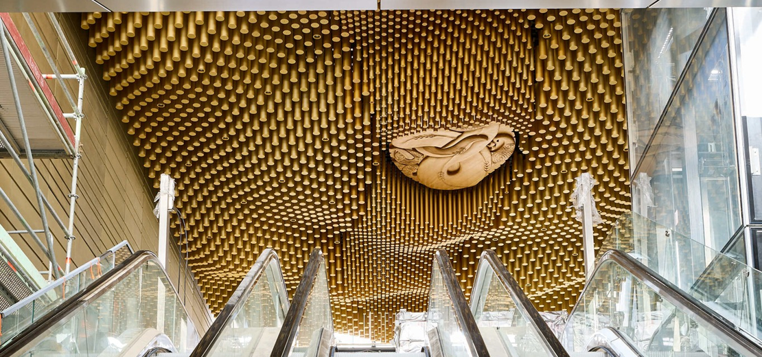 Te Wai Horotiu station ceiling art taking shape. Image: CRL
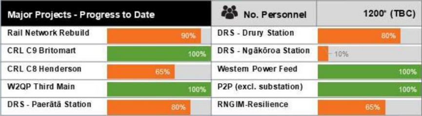
A good summary of where things are at and what is left to do is shown on this graphic.
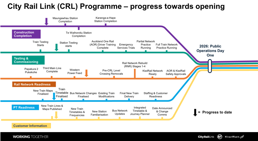
Breaking some of these timelines down a bit, they say:
- ‘Hard construction’ is due for completion in December and that will mean fewer cones and road closures.
- Station systems testing & commissioning is over 50% complete but critical next 3 months.
- Early next year they’ll be testing emergency services preparations (stage 6)
- AT want to fully test their planned timetable before going live. The update says they’ve moved this from post project completion to beforehand. This hopefully means we can get the CRL open sooner.
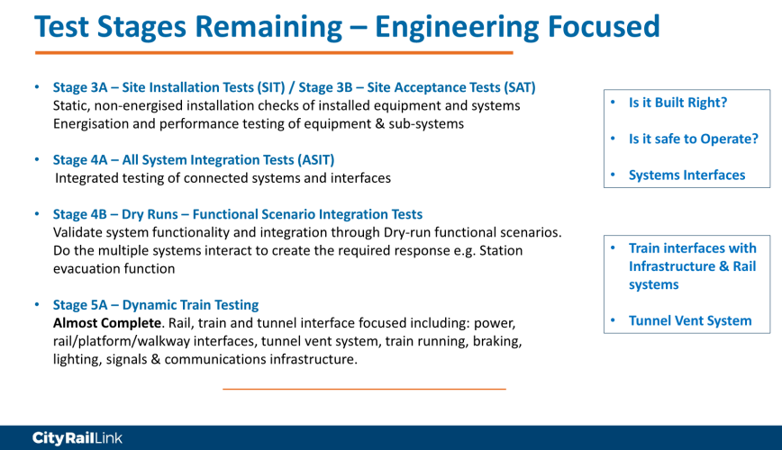
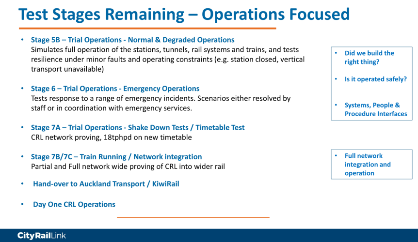
They break down the remaining test stages into engineering-focused and operations-focused, in these two slides.
Progress continues to be made on expanding the train fleet and upgrading the existing fleet.
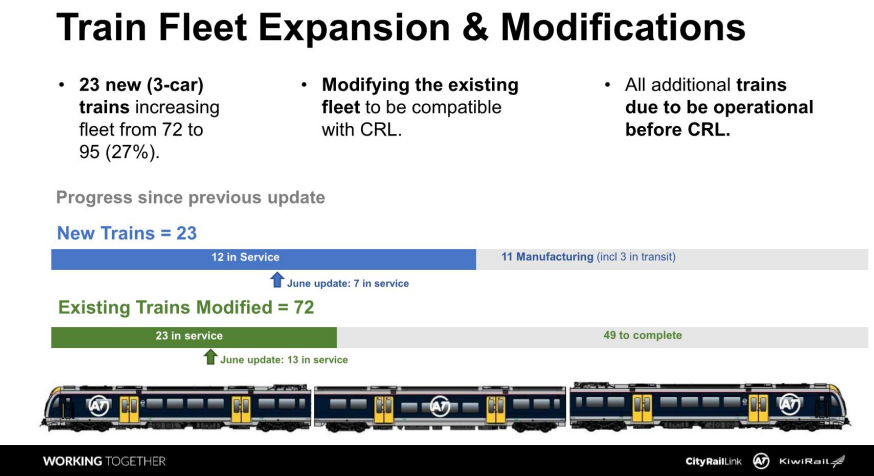
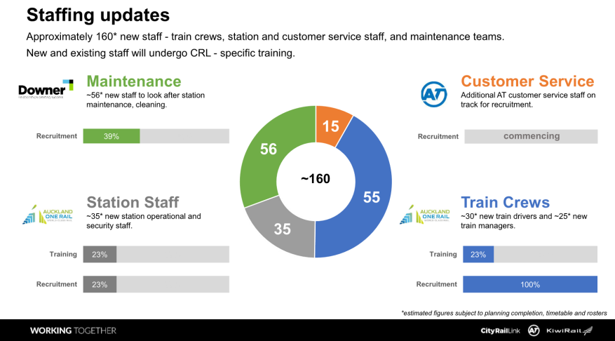
There’s also progress on hiring more people to both operate the trains and operate the stations.
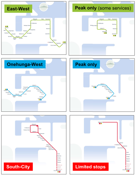
Last month, AT released their official CRL map, which we had some thoughts on. The presentation at TRIC includes these maps, isolating the various routes, which makes it easier to see the different service patterns but also raises a few questions:
- Are the peak only services on the Eastern Line only from Sylvia Park and not Manukau?
- There’s still not a clear picture of what will happen on the South-City line at the city end. Will services just alternate between going via Parnell and going via Grafton?
Maungawhau Station area
The Mayor recently pushed for a change at Maungawhau to divert some of the region’s busiest bus routes to duck in and stop at the station rather than staying on the existing arterial routes nearby. As I highlighted back in June, this would have the effect of delaying thousands of ongoing bus journeys in favour of some very limited improvements to bus-train transfers. The walk to and from the station from New North Rd and Mt Eden Rd is only around 250m, which is the same distance as you have downtown, between trains (Britomart) and buses (Lower Albert St).
In response to this, they’ve deferred constructing ‘Tunnel Street’ – which is the road that planned to come off Mt Eden Rd and sits above the tunnel. They say this is to provide a future developer with more flexibility, to allow “developers to consider the site as a whole to determine where accessways and open spaces could be built within their plans“.
They say they’re also investigating options to future-proof bringing buses closer to the station. There are suggestions this could involve setting back the buildings along Ruru Lane, to potentially turn it into two-lane road – which would risk it becoming a rat-run.
AT do say that “if these corridor(s) are to be implemented, they would not be able to be delivered in time for when the CRL opens and would need to be funded separate from CRL delivery funds“.
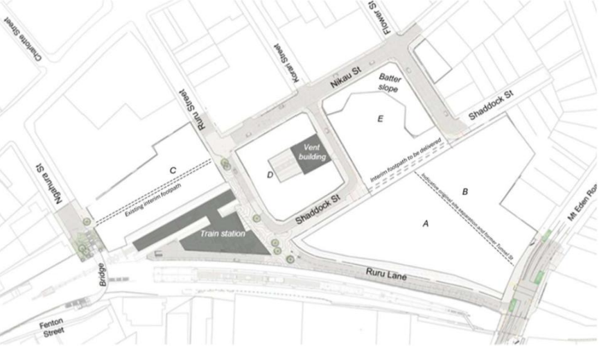
This is the current (new) plan, with ‘Tunnel St’ deferred.
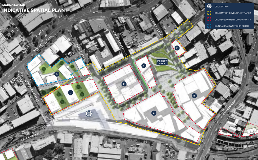 By comparison, this was the original plan
All of this effort to change plans and delay buses is simply to avoid this short walk:
Upcoming Disruption
The final CRL-related update is on the upcoming disruption and there’s a lot of it, especially for parts of the Western Line.
It appears that during the upcoming school holidays, we will see disruption on both the Southern and Western lines. Then from Labour Weekend onwards, the western line will see additional disruption. You can expect to start seeing communication about these planned disruptions from mid-September.
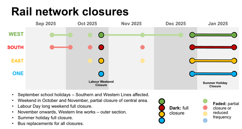
The work appears to be largely focused on the Western line west of Henderson, but also with some single-line-running around Morningside and Kingsland.
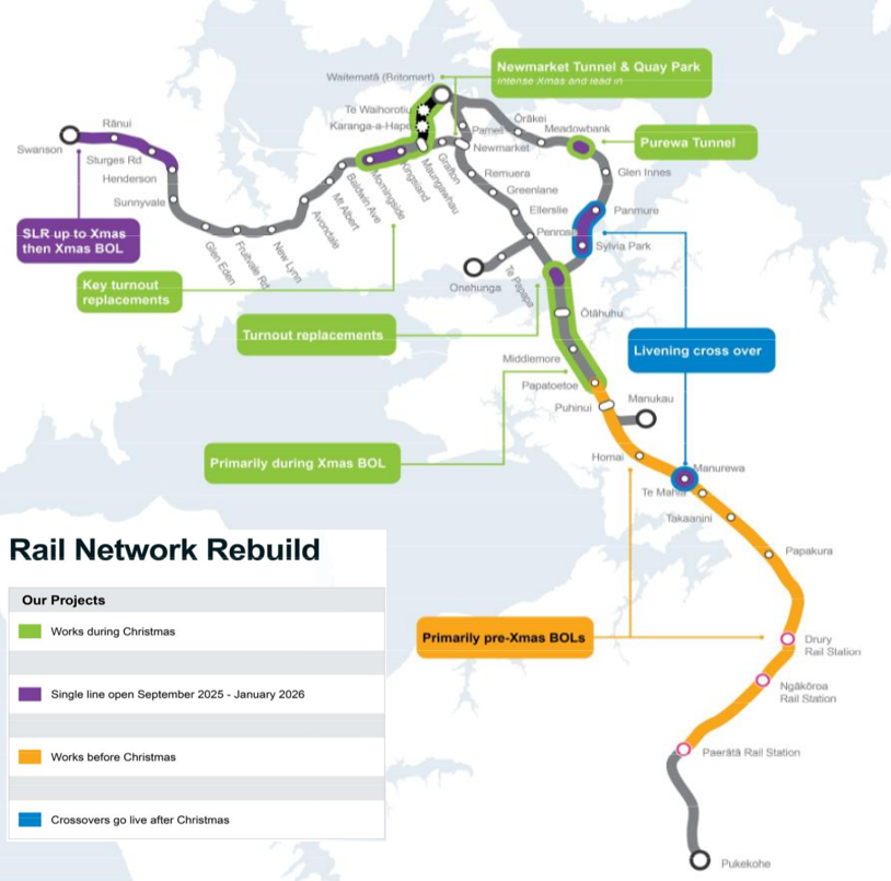
KiwiRail’s major project progress tracker is starting to see some green now. I’m very much looking forward to all of this disruption being over.
Special Vehicle Lanes
In a separate paper from AT wrapping up their last financial year, they include some information on their existing and potential network of special vehicle lanes (SVL) – which is primarily made up of bus and transit lanes.
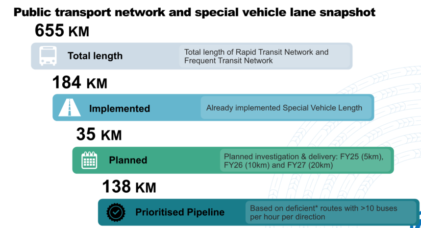
An almost doubling of special vehicle lanes would be a great outcome, and would really help in speeding up buses and improving reliability.
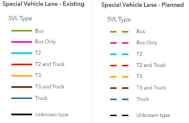
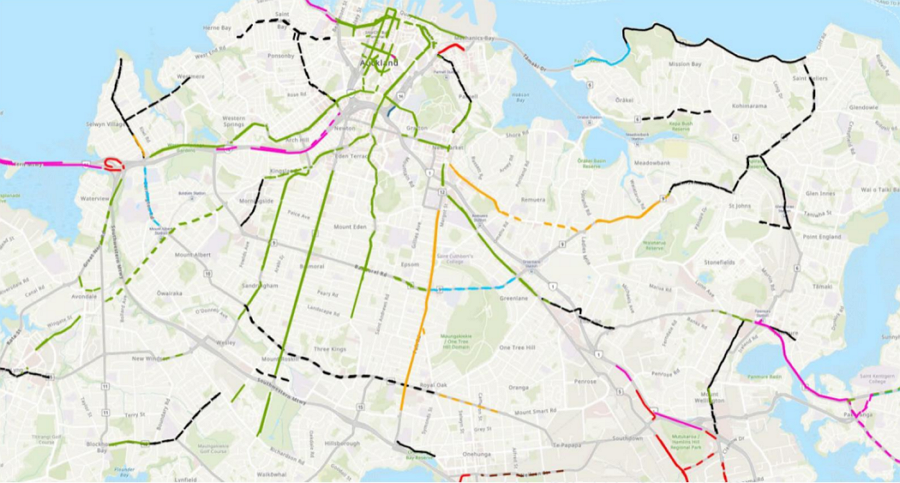
The maps show where both the existing (solid) and planned (dashed) SVLs are. (We have some questions around some of those lines, the mysterious black lines in particular – you might, too).
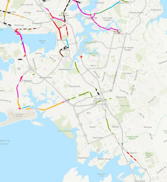
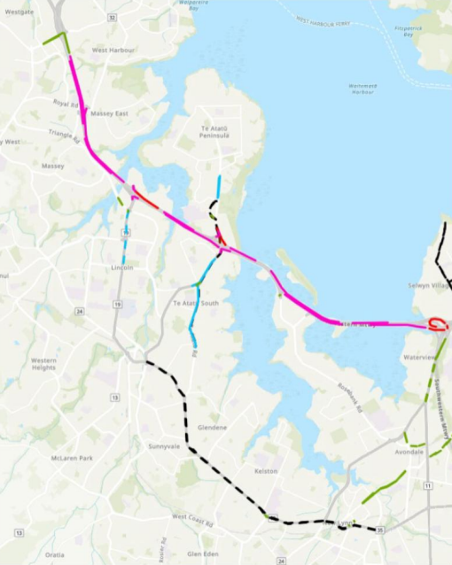
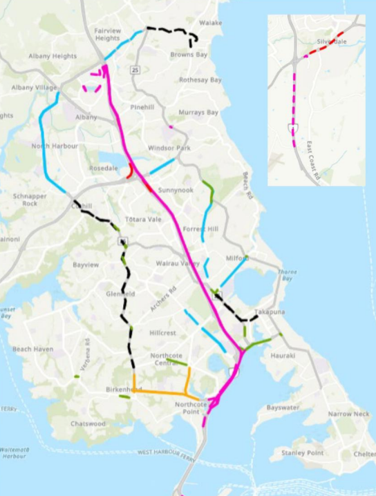
AT says that small-medium SVL projects take around 12-18 months to deliver, but complex ones, like Greenlane and on the Hibiscus Coast can take 24-36 months.
There are a number of other interesting papers from the agenda that we may look to cover separately.

 Processing...
Fantastic post – thanks for the update. The tone of CRL facebook posts has changed with a finishing feel coming in. However, it does seem like there is still a fair way to go (the spacing on the first chart leaves a lot to the imagination) but it’s great AT is bringing some of its testing in parallel.
The bus routing question and the subsequent changes/delays is a shame. An example of the Mayor’s over-sized ego coming to the fore? In the past he seems to have been swayed by clear logic – is he just not listening this time around?
Agree on the tone of the Facebook posts. Although those still posting against it are now blaming the artistic components of the new stations as a reason for the cost blowout and delay in opening.
At least we have moved on from “why does everything have to have a Maori name??”
The cost overruns and changes in the opening date, has been caused by Council requesting that the lengths of the stations be extended to accomodate longer trains, and to build the Northern line platform that will eventually connect to the North Shore
Where is the northern line platform? I knew it was future-proofed but which level would it be on and in which direction?
The North Shore line future proofing was always part of the plan, no?
It’s designed to be perpendicular to the Te Wai H station
FYI future proofing doesn’t mean building or even designing anything in advance, it just means “not make it impossible to build later”.
IIRC the main future proofing amounts to a space where connecting escalators could be added.
I think it is right of Brown to question this. Perhaps if they gave him a decent answer he probably would have accepted it. I suspect the answer was “we didn’t think of that, who cares about buses”
“We did think about buses but we don’t ignore you.” If there is a better way of marketing the development land, then that saves CRL the cost of finishing the station precinct. More time to spend on designing several options, only one of which will have to be built (eventually) by the developers. Meanwhile, just spend a bit of the budget on temporary works.
No, it’s a dumb question from a dumb guy. The answer is perfectly fine – we’re not going to delay millions of bus rides to accommodate a tiny handful of passengers who might want to transfer just to save them a 200m walk. Buses have been considered, that’s why there’s a stop right there at the walking entrance to the station.
The Mayor is just convinced that he’s an expert on Transport Planning. Dunning-Kruger personified.
And do we think these corridors will receive a full all-mode analysis required before slapping special vehicle lanes in? AT has certainly already done the work: The Roads and Streets Framework. Connected Communities. The Healthy Streets Framework (remember that one, before AT slipped it under the rug?) The VKT reduction work. The TERP.
A functioning and balanced network can only be achieved in Auckland by “Supercharging Walking and Cycling”. To plug ahead with major change on our corridors without restoring active transport would be utterly stupid.
Looking forward to seeing great plans for this.
Sadly I think it will be tasked with doing the easier, quicker bus / transit lanes only. New North Road plans from a few years ago were (IMO) pretty good overall, it’s quite a shame that didn’t go ahead.
I’m sure the blame for no cycling improvements will be aimed at the GPS and funding constraints.
Any support for the panicked speculation I’ve seen that opening has been sent back to 2027?
No, the update once again reiterates that it will be open in 2026.
Impression I was getting was that AT are getting overly risk adverse which was pushing things out e.g. they wanted to shut the entire network for days after all the work was completed to test the planned timetable (and potentially have to do it again if it didn’t work as expected). But they couldn’t do that till after March madness, and only after all of that would they then change staff rosters and plan the opening date – but there’s a long lead time for those too. There was a chance everything would be complete and CRL would be sitting unused for months while AT did this.
Been hearing that mayor and minister are pushing for earlier in the year than things were heading and that might be the comment about shifting testing to be before project completion.
By my calcs the CRL costs $657,655 a day to finance (at current government bond rates). Delaying it a month costs $20 million.
It doesn’t cost that extra though, it costs the same $$$ regardless of whether it’s open or not.
The costs of delay are economic rather than financial, missing out on faster trips and better access and increased agglomeration etc.
Surely they can test week day after their current lame end of service time or super early in the middle of the night or something. Staffing could be an issue but I’m sure they would all be excited to try the new timetable out and could be paid a bonus.
I am trying to listen to as many want to be councillors and local board members as possible before I vote in the upcoming local elections. Many have many negative things to say, and others claiming that we need cars, we cannot live without our cars.
As humans, we existed before cars, and I like to believe that we will exist after cars. I would also rather hear positive things about my local area, and more about the incredible urban ngahere project, and pedestrian areas in the city centre.
Cars kill us, fast and slow. Walking and inhaling trees is life preserving.
I would like our current and future community leaders to think in this way, that beyond the reality of climate change, this is the reality of us dying from things that we have invented, and that maybe we should rethink accepting this?
The Central Rail Link will bring South, West and Central Auckland closer together, and I hope that his will result in more apartments, the fifteen to twenty level constructions that seems to terrify the elder councillors. If the rest of the world’s cities, which are equally disaster prone to us, can construct vertical density, why are we still arguing about it?
bah humbug
Intensification of inner Auckland will have detrimental results unless we drastically redesign and improve urban amenities (their current appeal to residents is down to the character of the neighbourhoods more than relative proximity to our third world CBD).
While derided as ‘car centric’ – at least these neighbourhoods generally offer residents access to private outdoor areas (otherwise known as backyards).
These areas host urban wildlife and plants.
It would be a pity to destroy this with poorly built and apportioned apartment buildings (Ockhams aren’t selling and the only reason the company is even solvent is because the government are underwriting their debts).
I think the initial focus should be on (currently) non-residential areas such as the top of Dominion Road / New North Road. As they fill up then intensification should be pushed outwards.
Anybody who thinks that we can simply consent our way to Western-European style urban living is dreaming.
Developers can only build on land that someone wants to sell to them. If they can’t buy enough adjacent lots to build good homes with good amenity, they’ll carry on building the same they are now. It seems very few of them know how to build good compact, affordable homes. No regulation, guidance or education on good design can’t be cured just by zoning rules.
The government are missing a trick by not commissioning medium density building templates / patterns for developers to use. This is what NSW has recently done (although its too early to say whether this idea is successful or not).
My understanding is that developers can purchase a license to utilise a set of these plans and then enjoy a streamlined consenting process to help them get built with a minimum of approval spending.
The designs themselves are from private sector architecture firms and many appear quite attractive (and most importantly liveable).
NSW has recently commissioned a set of these. One of the sucesfull designs came from Wellington firm Spacecraft.
People in the affected area might feel reassured if there was some kind of similar quality assurance in play.
I speak as one of those people. I don’t stand with the ‘no change at any cost’ vocal NIMBY fringe, however I don’t trust developers nor the government to do a good job.
I spend 4 mins on their website and the majority are sold if you look at the Plans & Pricing tabs, especially on the completed or near completed buildings. The more expensive Meadowbank one only has 14 but “Construction is scheduled to be completed in Quarter 4, 2026.”
Actually the Pt Chev one has about 40% sold, especially the corner bigger ones. Completion Oct this year.
From what I’ve seen, Ockham apartments are some of the best in NZ, built well and surely are selling? Maybe they take a bit longer to sell as tend to be at the upper market end.
Our CBD (City Centre now BTW) is far from 3rd world. There are some good urban amenities at Wynyard Qtr and existing Albert Park for two quick examples. Also the Wynyard Point development (Te Ara Tukutuku) will be another awesome public facility.
Get with the times, apartments are not for everyone but are for a lot of people. We could do with some more suitable for families, though, without being overpriced penthouses.
Anyone who thinks our CBD looks like the 3rd world hasn’t been to the 3rd world, most of the developing world, or the CBD itself.
Unfortunately they are not – this is why the government is underwriting them (recognising that they’re quality developers).
For proof, have a look at their websites where they list apartments for sale – plenty available (not a good thing).
Consenting expenses are a big part of this (driving up purchase prices) – something that might be reduced by the proposed changes.
This isn’t something to automatically bet the farm on though, the Labour government’s intervention in Auckland’s planning (the medium density housing standards) flooded the market with cheap infill housing – seriously cutting the lunches of apartment developers like Ockham (and giving rise to much of the damage from the recent flooding events while doing so).
This isn’t a matter of being against apartments, it’s a matter of being against the typical New Zealand apartment and the typical New Zealand property developer.
Good design in this country remains the exception and not the rule.
Calling the City Centre Third World is about as insulting and dumb as 40,000 residents living there characterising the inner suburbs as being chocka with boomer racist nimbys.
What on earth is an ‘Unknown type’ of special vehicle lane that is already existing!?
I asked the same thing myself, but I think it means they haven’t decided between bus/bus only/T2/T3 etc?
All the black lines are dashed (“Planned”). The ones which appear solid, are due to the dashed lines overlapping.
Ahh, that makes sense. Thanks.
Those maps are terrible visually speaking. How can dashed lines overlap? In any case why is a big section of Tamaki Dr currently unknown?
actually it has black solid lines in the key under the “existing” section… this would infer there are indeed existing unknowns wouldn’t it?
Should they not have put “except cycle lanes” somewhere, to clarify none of this work is about the cycle network and none of the planned special vehicle lanes are cycle lanes?
Or would that complicate things, because Bus Lanes allow cycles?
I suppose the solution is as I mentioned above.
@MattG – Yes, unfortunately the map key which was screenshotted does indicate that there are solid black lines indicating Existing Unknown Type. However in the source document, you can see the keys on the other maps do not include the solid black line: they only include dashed black lines, with the label changed to “TBC” rather than “Unknown Type”.
@Grant – A situation where dashed lines overlap is when there are planned special vehicle lanes drawn running in both directions of the road: eg along Tamaki Drive, Pt Chevalier Road. When zoomed out, the dashed lines of the two directions overlap and clash: the dashes of one lane fill in the ‘gaps’ in the other lane, resulting in what appears to be a solid line. If you look closely at the solid lines in Pt Chev and St Johns, you can see they’re not fully solid.
“unknown type” seems to be the Special Vehicle Type most planned for (black dotted line) on the map.
Which must make planning quite tricky.
Maybe its the pre-election code word for “cycle lane”, or active mode corridor.
Notable also is the lack of continuity in the networks, lots of short sections.
I think it just means they know they need to do something (based on bus volumes) but haven’t yet done the investigation to determine what kind of lane is needed (bus/T3/T2)
That doesn’t explain the ones that are already existing, surely it could be answered by going for a drive and seeing what is painted on the road, if it is missing in their existing documents.
“Notable also is the lack of continuity in the networks, lots of short sections.”
That is much less of a problem for bus and truck lanes than it is for cycle lanes. For buses and trucks (and, sigh, HOV), you want to allow queue jumping of delay spots, mainly. And even if the extra lane isn’t always in the perfect spot (because the perfect spot has constraints etc) they may still be very useful to shave off some time.
Cycle lanes meanwhile? On busy road every missing section, even if it’s only a 100m or so, means people have to be willing to ride next to heavy traffic, fast traffic, aggressive drivers, drunk drivers etc… with no extra space and protection. Even a short weak spot will turn many off.
In short: Bus lanes and truck lanes are about delay. Cycle lanes are about safety, and thus need a lot more consistency before they work to get the numbers up.
Exactly. And as bike lanes require this continuity, the locations for bus and truck lanes needs to be determined at the same time, or after, the space for the bike lanes has been allocated.
Absolutely agree with your comments about bike lanes, but lack of continuity of HOV lanes itself generates bottlenecks. For example, the absolute insistence on keeping on road carparking on Remuera Rd through the Upland Rd shops (in an area well served by a large off-street council carpark) results in huge delays and traffic queues as everyone (buses and cyclists included!) is funneled down to one lane for the sake of a couple of hundred metres. Far better to remove the carparking (at least during the hours of T3 lane operation, though all day would be better!) to allow the road to actually be used for transport. Better again would be also reallocating the space used by the median strip to allow for bike lanes, but now I’m really dreaming…..
If you remove the parking for traffic at peak times, then you’re releasing one small valve that’s keeping a ever-so-small lid on traffic volumes.
Redesigning the road for continuous bike lanes would remove the parking, but keep that lid on traffic volumes at the same time as providing an alternative mode, safety, and a lane with a higher potential person flow rate, thus, providing knock network improvements.
Not that Ruru lane is a bad option necessarily, but I am a little perplexed as to why the emergency exit onto Mt Eden Rd was not just specced out to be used full time.
Is there a specific safety reason that wasn’t done or something?
Those platforms will only be used by the relatively low frequency Onehunga service. Most passengers will likely want the more frequent service via the CRL that uses the other pair of platforms. A Mt Eden Rd entrance would mean walking the length of the platforms, going up and over to the main station building and then down to the CRL platforms. Easier to just walk down Ruru lane. A second entrance would presumably need gates + staff (more $$$) for likely very low use.
I realise he is THE MAYOR, the head honcho and all that but how come he can “push[ed] for a change at Maungawhau” and everyone jumps? What special knowledge does he have that the legions of planners, consultants, public inputters and approvers missed that means the project now needs to jump through hoops to satisfy his push? Does nobody have the communication skills to explain the planned outcomes and how they will be achieved or did all those people end up perpetrating the wrong group think solution?
It’s late stage reckons like this by a person who claims to be an engineer who has completed many projects and knows the risks that will push the go live into 2027.
I guess you need to ask if the “legions of planners, consultants, public inputters and approvers” even considered bus connectivity, and if so why did they decide it wasn’t needed?
“All of this effort to change plans and delay buses is to avoid this walk” – by that theory we don’t need decent bus/rail interchanges anywhere, people can just get off the bus on the street and walk 200m to the station. Puhinui and Panmure were a waste of money…
Puhinui and Panmure both have 150m distances between bus and train. However there is a difference that Puhinui and Panmure are both major interchange points with a lot of people changing from bus to rail to get to the city.
Manugawhau isn’t, it’s one stop out of the city centre and very few people will change to a train there. It really only make sense for someone on Dominion or Mt Eden Road that wants to go out west. Anyone going to the city will stay on board, and anyone from the new north site will have transferred already back at Mt Albert, Morningside or Kingsland.
They said it was something like five out of a hundred bus passengers would transfer there, so it’s a case of delaying 95% of people for a few minutes to save 5% a few minutes.
Ruru Lane is going to need to provide vehicle access to the vacant development land block A. The other frontages of block A can be active frontage onto vehicle-free Laneways. Or not, if someone has a better idea. And don’t forget the level differences between New North Road, the station and Mt Eden Road.
A nice sandpit for everyone to play in, if you don’t mind it still looking like a sandpit when the station opens.
“I realise he is THE MAYOR, the head honcho and all that but how come he can “push[ed] for a change at Maungawhau” and everyone jumps? What special knowledge does he have that the legions of planners, consultants, public inputters and approvers missed’
Answer. Len is an self proclaimed expert on everything
Personally, I think having people walk 250m to link trains/buses is a bit of a fail when we had a chance to plan this properly from scratch.
Agree. If they did have a genuine reason to go with the current design (other than “who cares about buses”), can they please explain that reason?
The genuine reason is: ‘we care about buses’. A 2-3 minute detour for all bus passengers to save a 3 minute walk for a few passengers is a stupid way to operate a bus network
If you are on a Dominion Road bus you have already been significantly detoured via View Road, the only possible reason being access to Mt Eden Train Station. Why do that “for a few passengers”?
I suspect it will be more than a few. Pretty much anyone who is not going to midtown, and who wants to go there.
The Dominion Rd buses go via View Rd because that’s the way the trolley buses were sent when the flyover was built. It’s problem that’s easy to solve and should be.
Tge Dominion Road buses should not detour along View Road. The only reason they have stayed there is because no one has cared about the bus.
:The Dominion Rd buses go via View Rd because that’s the way the trolley buses were sent when the flyover was built. It’s problem that’s easy to solve and should be.”
Incorrect: AT added approx 12 additional double decker buses to increase capacity along that route, and routed them via Ian McKinnon Drive. A minority of passengers complained that they were being inconvenienced. After about 2 weeks of complaints AT switched the route back to travel via View Road
Fair call. Perhaps has something to do with feasible CRL underground exit points and station platforms? Otherwise a station closer to Mt Eden Rd might have been good opening the back of the site for development (business up front, party at the back). But that would then make it further away for those catching buses on New North Rd.
But yes, a clear statement from AT or CRL would be good.
It’s a pity the originally planned underground station for Newton was going to be so expensive.
cost seems a bit of a moot point at this point but i believe in terms of technical feasibility that a Newton station would have prevented a grade-separated flying junction where the CRL joined the NAL, and potentially limited platform (and therefore train) lengths to 180m instead of the full 9-car 216m trains?
That’s a bit technical for me but those problems do sound formidable.
The main problem was the platforms for each direction would have been spread apart on a different level to have it grade separated. Which is basically the same as building two stations instead of one.
Of course that didn’t stop them building two stations at Maungawhau, one of which is all but useless.
if connections with the isthmus buses was the priority of the whole CRL then the original CRL plans with Newton station and the Inner West interchange/Dominion Junction station would’ve fulfilled that better.
O for a mayor who would seek to understand this.
Would staff feel more comfortable explaining reasoning to Leoni?
Agree, but I think that was too expensive?
I doubt the Mayor wants to spend any significant amount of money, just something a bit better than the current nothing.
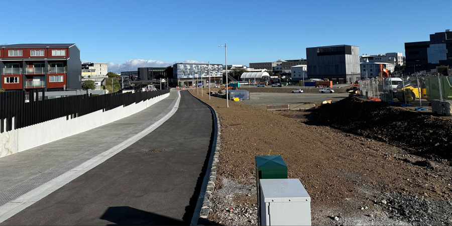
As long as whatever they do doesn’t end up re-purposing that bike path in the photo as a road lane…
It’s a service lane
What does the “Modifying the existing fleet to be compatible with CRL” entail?
I believe it is things like improving fire resistance and also upgrading things like radios and modems etc. The original trains are now over a decade old and so a lot of the technology has advanced a lot
I’m I correct that the plan for Lincoln Rd is going to be a T2 section? Surely with WX1 there needs to be better PT connection here.
If trains on the south city line are going to alternate via Parnell and Grafton I am wondering if passengers decide just to go around the loop to get to their required station will there be an additional cost for taking the long way. I suspect it will have to be the same because how would the cards know which way you came. I would prefer if trains just ran one way to avoid confusion. Still I suppose if we have centre platforms it’s not to difficult but imagine Boarding at Parnell it’s a long way to change Platforms.
I am also interested in how trains will turn around at Slyvia Park. Presumably they could continue on heading south to the turnouts behind where the old paper coating sidings used to be. Alternatively they could just reverse and run wrong line back to the turnouts at the old Tamaki station site. Or maybe they will do either depending on circumstances. I can see this causing immense confusion in the event of holdups on the network.
Given that whole area is in the same zone I can’t see why it would make any difference.
Pretty sure there is a new (high speed) cross over just past Sylvia Park, I remember a video & updates on that (plus others) getting put in. See the map for livening that.
If you’re going to display images with very small text, please use much higher-resolution images or provide links to sources.
I looked at the sources, and that seems to be the quality what the document in the Council agenda has (and that is linked right at the top, very first hyperlink). Greater Auckland presumably doesn’t have a magic AI sharpener to blow up the resolution of files that Council compresses…
As Damian notes, this is the highest quality I could find and the link is in the first paragraph. It is unfortunately quite common for council and AT papers to have low quality images in them.
Just say “ENHANCE” to your computer.
You should hear what it says back 🙂
Lincoln Road needs far more than a T2 lane.
A dedicated bus lane, cycle lane and protected means for pedestrian crossing at the very least.
Ideally the whole road would be atom-bombed from outer-space and a gondola strung across the steaming crater.
I see a series of T2 and bus lanes planned for Pakuranga Rd, I can hear the outrage brewing already.
Putting aside any minor annoyances, I’m feeling quite excited reading the graphics and this post seeing everything coming together for this mammoth project – the biggest in NZ to date.
Let’s hope the have a speeding up of dwell times hidden in their new post CRL timetable, but not holding my breath on that one.
Auckland trains excessively long dwell times significantly impacts travel times. Missed my bus home last night because of this. A common & unpleasant experience transferring between transport services for many. Hopefully 2026 is the year of fix to correct this.
Reducing dwell times would reduce the amount of time the gormless train guards get to stare at their phones though.
For all of the transport and timetable planning experts out there, now is your chance to step up. AT is seeking proposals for a new suite of Public Transport Data Planning and Scheduling Tools. The aim of the process is to seek and obtain information from organisations about the potential supply of public transport (PT) planning, scheduling, and data management solutions for AT. AT is seeking to explore alternatives to its current PT planning & scheduling toolset with a solution or solutions that improve operational efficiency, supports strategic planning and aligns with AT’s long term transport goals.
“Are the peak only services on the Eastern Line only from Sylvia Park and not Manukau”
– I would read that as just some peak services. Also “A train every x minutes map” I’ve got shows 8 mins from Manukau and 5 between GI and Meadowbank so this would match that idea.
There’s still not a clear picture of what will happen on the South-City line at the city end. Will services just alternate between going via Parnell and going via Grafton.”
– Have new *paper* brochure that I picked up that states it will indeed alternate clockwise and anticlockwise around the city end.
Quite nice if you live or work in Newmarket I would think as can go either way but if take wrong one or if don’t want to wait, just go around the loop.
Is it four trains an hour alternating then? That means only half hourly each way through the city.
Hmm good point but think it would be at least 15 mins through Parnell each way (at peak). Parnell will be the least of the “city” stations so some will have every 4 mins when combined with the other lines.