The City Rail Link is going to be one of the most transformative projects Auckland has ever seen and it is now, most likely, less than a year away. Auckland Transport are more visibly starting to get ready for it, and yesterday they officially unveiled their rapid transit map for once CRL opens, including what they’re calling each of the lines.
As much as I love the project and want it to succeed, I can’t help but feel AT have fumbled the ball a bit here, both with the network and the map.
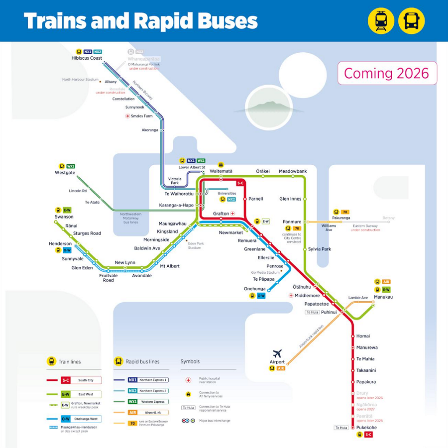
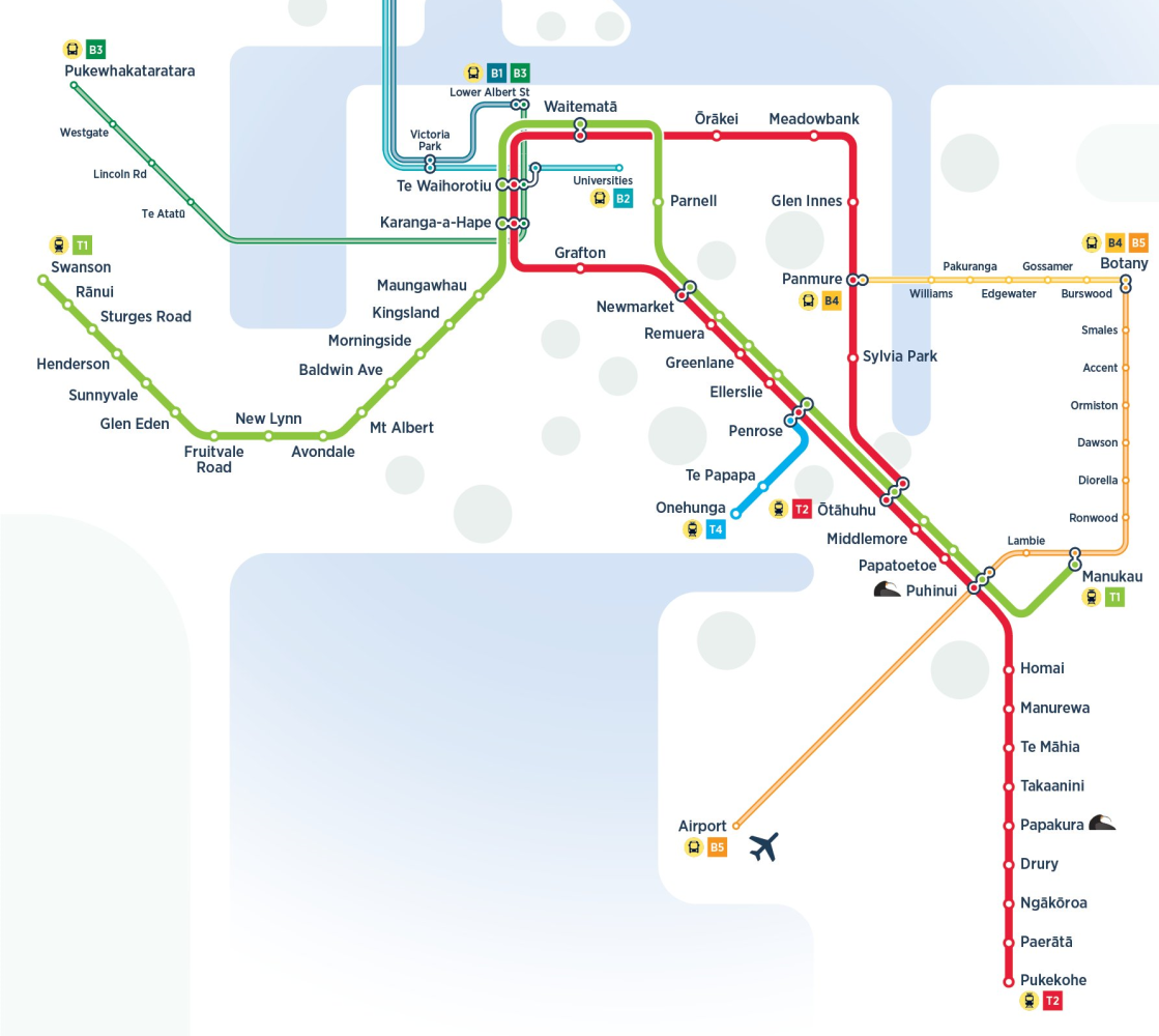
More direct access to the city centre and a cross-city service are the key features of the just released ‘Trains and Rapid Buses’ map, that highlights the scale of public transport improvements which will come into effect when the City Rail Link opens in 2026.
CRL allows for big changes in the way customers can travel across Auckland. The network has been re-shaped with Auckland Transport adding new train lines and bus connections to provide more choice and faster journeys.
“It’s exciting to be able to give people a clearer idea of how their train journeys will change, as many people don’t realise that City Rail link benefits all of Auckland and the whole public transport network,” says Auckland Transport Chief Executive Dean Kimpton.
The re-configured network makes it easier for Aucklanders to connect to the places they love to spend time in, and more convenient access to the places where they work and learn.
“This is more than a map, it shows how people can more easily connect with friends and loved ones, attend events, shorten their commute or just explore a new part of the city by rail.”
Three new central city stations – Maungawhau, Karanga-a-Hape and Te Waihorotiu – alongside a better-connected Waitematā Station (Britomart), are the cornerstone of the route improvements.
The new underground twin tunnels from Waitematā Station mean trains can travel straight through the middle of the city – unlocking capacity for more frequent trains and reducing travel times.
90% of all train services will pass through the underground tunnels and city centre stations on new routes replacing today’s Southern, Eastern, Western and Onehunga Lines.
The Design
First up, this would be the perfect opportunity to brand the rapid transit network as a whole. Give it a name instead of just calling it Trains and Rapid Buses. The simplest would be something like Auckland Rapid Transit (ART) and there are heaps of ways clever marketing people could play off that.
Bringing the network properly together should also entail having a common naming convention for the lines that make up the network. Instead we continue to have a bit of a hodgepodge of names.
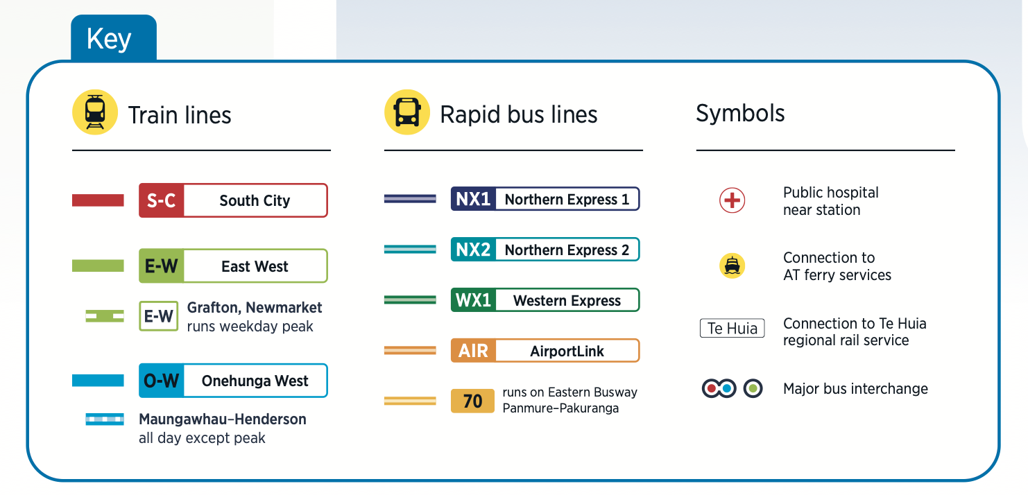
With the changes to the rail network we get three new names for lines: Ewww, Ow and Sick. There are plenty of different naming conventions out there but even something as simple as a single letter might have been better e.g. the A, B, C lines etc.
Having a common naming convention would also help in breaking down the modal silos that seem to persist at AT and which also feature prominently on the map itself with the design of the lines. I wish they’d just use the same line style for all rapid transit services.
The map is at least an improvement on the previous version:
![]()
Network Design
We’ve seen some versions of the network design before, and I remain unimpressed.
E-W to Newmarket
AT’s plans are that services will increase to 8 trains per hour in the peak direction on each of the main lines – up from 6 currently. However, with all of the level crossings on the Western Line, AT don’t want to run any additional services overall so there will only be 4 trains an hour in the counter-peak direction – a reduction on what we have today.
The E-W line having some services run to Newmarket will be the additional services from the Eastern Line that won’t be able to head out west due to the level crossing restriction needing somewhere to terminate, and Newmarket happens to have a spare platform once it’s no longer needed to turn around Western Line trains.
O-W to Henderson Off-Peak
I get the desire to retain some semblance of West to Newmarket service but having it occur off-peak like this is just daft. AT would be better to use the resource to boost regular western line service from the currently planned 4 trains per hour to 6 trains per hour.
Transfer between services will be very easy at Karang-a-Hape and the higher the frequency, the more chance that it will actually end up a faster overall journey than a train that only runs every half an hour.
S-C Line double back
The doubling back of the S-C line adds confusion. The train plans we’ve seen from various documents in the past suggest services will come in from the South, run through the CRL and head back to terminate at Otāhuhu. Why hide that?
Having two red lines side by side through the inner southern line would make it clearer compared to merging the lines like AT have done and helps to highlight the additional service.
CRL Day One?
AT does note
Auckland Transport is currently finalising these service patterns and timetables. The train operating timetable is subject to approvals. More detailed information on specific route variations and services for each line will be released soon.
Putting that aside, an even better network option might have been something like this – as shown by Nicolas Reid in this post.
A more useful way to run the trains? Image credit: Jug Cerovic
What do you think of the official map?
This post, like all our work, is brought to you by the Greater Auckland crew and made possible by generous donations from our readers and fans. If you’d like to support our work, you can join our circle of supporters here, or support us on Substack!

 Processing...
Welp, I saw the map yesterday, and I thought “can’t wait for the Greater Auckland post where they say what a fail it is”, and I wasn’t disappointed
More constructively:
– there are already obvious names for the 3 lines, which will be naturally used: Red, Green, Blue.
– the main static I’m seeing on Reddit is from West-Newmarket consumers who are upset that their connection is going to be *reduced*. I know that transport bloggers know better, but suggesting a change that it should be *eliminated altogether* is tone deaf.
Oh, and I just realised that Nicholas Reid’s map, apparently the preferred route of this blog, would mean Maungawhau platforms 3/4 would be totally unused.
Yeah, cos there is not a good use for them. Except, here’s an idea.
How about terminating inter-regional trains there, while they’re still diesel hauled. Unlike the virtual nowhere of The Strand, from there the city centre and the west is immediately accessible from the station, and many buses from the Isthmus. Obviously more southern destinations can be accessed from earlier stops.
Quality new station for intercity arrivals and depart on the city fringe, a way better gateway, plus actually well connected by train and bus.
Also by using the Southern Line for inter city trains de-conflicts Eastern Line and port freighters. Or if refuelling and trains paths are still preferred via Quay Park they can use the Parnell branch (especially once AT drop the confusing alternating southern line pattern).
This map and its naming pattern highlights a lack of vision in transport governance in Auckland. That is the over arching strategy it betrays to me. Let me at it!
And from 1news last night ;-
https://www.1news.co.nz/2025/08/05/explained-how-city-rail-link-will-redraw-aucklands-train-lines/?fbclid=IwY2xjawL-ChhleHRuA2FlbQIxMQBicmlkETFlcG9YdVl3RVZTakxLZlJuAR7qZxLlsOhK6t1S5BzVfnGTNnmYzQx06ZiHQYDVpnIyfs9ey81S_jQVOgqOzQ_aem_IRTbkGPf0faQUf-g7YeY9w
I like the idea of terminating Te Huia at Maungawhau. With a stop at Grafton as well, linkages to the wider bus network would be really straightforward and even less hassle.
Maybe a stop at Newmarket to add to Puhnui, but is an intercity service, so won’t be stopping at every suburban station.
The main hinderance to terminating regional trains at Maungawhau will be the frequency of metro services between Penrose and Newmarket.
It’s higher than any two tracked part of the network, so would result in Te Huia crawling along behind a stopping service.
3rd track it!
DavidByrne Te Huia stops at the Strand for an Hour before heading back to Hamilton so stopping at platform 3-4 will not work unless they can lines fot the subbies .
Daphne, I would frame it differently. Right now people travelling from the west to Newmarket can take any train on the main line, every ten minutes at peak times.
In the new network, they are saying that people travelling to Newmarket need to take the blue line instead, which runs every thirty minutes, and not the regular green line which goes every fifteen… except at peak times when the blue line doesn’t run at all, and you need to take the normal green line and transfer at K Rd to the red line.
My suggestion uses the same amount of trains and same tracks, it just puts them all on the main green line at all times. So people going to newmarket at any time of day can just take the next train (coming every ten minutes or better, all the time) and transfer to the red line, and catch that to Newmarket or any other southern line.
Which one is the *reduction*, I would say the line that only goes once every half hour and doesn’t even run at peak times is a reduction.
What would be nice to see is current usage data (on existing lines). And forecast usage on new lines. I expect (hope) that has a large contribution to the network design. Do AT share this?
Existing AT patronage/boardings by station is available. You can then interrogate the data to show the start point and final destination station of all train trips. You can request access to this data from the AT IT/BT department
Can someone explain the EW-Newmarket segment in simple terms, I am failing to understand it; also another trigger for frustration at the complete lack of a real plan for the western level crossings. It will literally be decades before they can run the line at full frequency. Maybe I can grab a gold card by then and enjoy the fully unleashed western line by then. Oh well, I am looking forward cutting ten minutes off my commute at least once the CRL opens.
At peak times, some E-W trains will go around the bend to Grafton and Newmarket (and back) rather than go out West.
I see, but only in the off-peak direction?
It’s quite simple really. A dotted line means both ‘never in the peak’ and ‘only in the peak’.
No only during the peak. Basically 8tph will leave Manukau during the peak but only 4 will continue to Swanson, so the remaining 4 will run to Newmarket instead.
So if it’s the end of the day and I want to go out west to New Lynn then the frequency will be half the normal? Isn’t that a downgrade? Or is that morning peak only?
There will definitely be 8tph heading west to Swanson. I think what will happen in the evening is there will only be 4pth running from Swanson to the city, with an additional 4 departing Newmarket to give the 8tph to head east to Manukau.
So, so the inner south and east are going to get additional extra service while the West suffers.
Cant wait to do same line transfers, or even more fun EW-SC-EW.
Also, if the west is getting this treatment, why is all the housing intensive being out there?
Running a 5 billion dollar project at reduced frequency because some car drivers will be inconvenienced is ridiculous.
On their website AT suggests that the people that currently use the Western line to get to Grafton and Newmarket should use buses from K’rd: https://at.govt.nz/projects-initiatives/city-centre-projects-and-initiatives/city-rail-link-auckland-s-new-network-in-2026/how-the-train-network-and-timetables-will-change-for-the-city-rail-link which is great in theory, but I really think that a train-to-train transfer is going to be much more reliable.
Having an off-peak only Henderson to Onehunga service seems very weird. Bearing in mind the frequency of that service transfer at K’rd station is likely to be far better time-wise, so why not just boost frequency of the EW (or WE?) line and have Onehunga line terminating at Newmarket?
The doubling up of the CS line over the loop will definitely be confusing, let’s hope AT quickly comes to their senses and at least adds a letter or a number to the route (like we have with the Inner Link A/C) to make it easier to spot the right service.
Frequency out west in the off-peak direction is an absolute joke IMHO. That’s a serious reduction of the service and clearly shows that planning inside AT is firmly stuck in “people only commute to and from city centre at peak times) world.
Wow they have no idea what they’re doing. Train-train transfer will be so much faster.
Does anyone at Auckland Transport ever actually use PT?
This is disinformation spread by people who’re not reading the link.
“For Grafton or Newmarket, change to a South-City Line train service at Karanga-a-Hape Station. ”
They literally recommend train-train transfers, or train-bus as an alternative.
People WANT to believe the worst about AT.
“Does anyone at Auckland Transport ever actually use PT” Most of the staff at AT use PT, walk or use bikes. There is no staff car-parking at the AT HQ building.
The Link’s A and C destination board signs are pretty much useless for two reasons: (1) they are relevant only at two stops on the entire Link route (both at Westfield Newmarket where buses are running both directions from the same stops) and (2) there is no explanation anywhere as to what the letters actually mean – you have to work it out for yourself, and then figure out if your planned journey is clockwise or anticlockwise. I’d rather actually show the “INN” route on the destination board so that unfamiliar users can actually align it with the stop’s info display. Or is that too logical?
Berlin uses actual clockwise/counter-clockwise indicators on their Ringbahn, see here:
https://sbahn.berlin/fileadmin/_processed_/9/a/csm__DSC9945_025517fba0.jpg
Yes I use that little circle arrow indicator every day, so easy to see at a glance.
They also have different route numbers for each direction which helps a lot. There is no S4 train line in Berlin, only an S41 clockwise and S42 anticlockwise.
Will be interesting to see how people fare with the red line looping both ways in both directions in the CRL.
What a mess. Can’t believe how badly rail operations has been messed up for City Rail Link. Just run the map above – or if you must extend the Onehunga Line to Newmarket and Maungawhau all the time.
” extend the Onehunga Line to Newmarket and Maungawhau all the time.”
That’s… exactly what they’re planning to do
No they’re not. They’re doing some weird complex thing where at peak times the Onehunga Line extends to Maungawhau but off-peak it goes all the way to Henderson for some weird reason.
No, no, no. The Onehunga-Mangawhau line runs all day. It’s the extension out to Henderson which only happens off-peak
Agree with almost your entire critique. I’ve been keeping my fingers crossed that there would be a new “rapid” brand, and I was disappointed. I was hoping there’d be an integration on the map of the train and express buses into one graphical and nomenclature “system” and I was disappointed. I was hoping for a naming convention that distinguished train and express buses by line number (T1, T2, B1, B2 etc – or R1, R2, R3 etc) or whatever. Or to have names like the Hillary Line, Ngata Line, Sheppard Line, Vogel Line, Savage Line etc etc. Again disappointed.
I’m also a bit flummoxed at the inclusion of bus route 70 but at the same time the exclusion of 11, 83 and 866, all of which are “rapid” for significant portions of their journey. Or maybe the inclusion of the 70 is a teaser for the introduction of an EX1 running from Botany to Panmure (or even Ellerslie). Hopefully.
There’s been a change in name for the “Westgate” terminus to “Northwest” – logical given the current confusion as to “which Westgate” buses are terminating at. But that’s been reflected only on the map, and not in the index, as I found when I did a quick sample to find one index entry which just happened to be “Northwest”.
Overall, underwhelming. I hope that AT takes the opportunity to revise and tweak the map and nomenclature systems before actual launch. Otherwise, a badly missed opportunity.
AT seems completely unaware of the importance of clear, readable and consistent conventions, too, as evidenced by the appalling state of bus destination boards. If they haven’t faded to the point of illegibility (as many have, leading to many missing their buses because they didn’t flag them down in time), that is. And then there’s the inconsistent positioning of the route number (some kerbside, some roadside) and the inconsistent route number size (some bold and easily legible, some spindly and really had to read) and typeface used (think TfL’s universally-used and highly recognisable typeface). And the use of the letters A and C on Inner Link routes as if they were route numbers – but providing no explanation as to what they mean of why they’re important. You have to work it out for yourself. And I’ve lost count of the number of times I’ve seen unfamiliar users looking for an INN or CTY bus, only to have to tell them that they don’t actually use those route identifiers in practice – just on the displays. Why oh why?
I think AT’s PR team need to be actually sent out to use the buses on unfamiliar routes for a couple of weeks before they’re allowed to start projects like this!
The team at AT that used to plan and implement bus stops signage and bus route numbers, was made redundant during the many cost cutting restructures over the last 5 years. The middle managers who were responsible for those restructures, were then also made redundant, resulting in a loss of institutional knowledge.
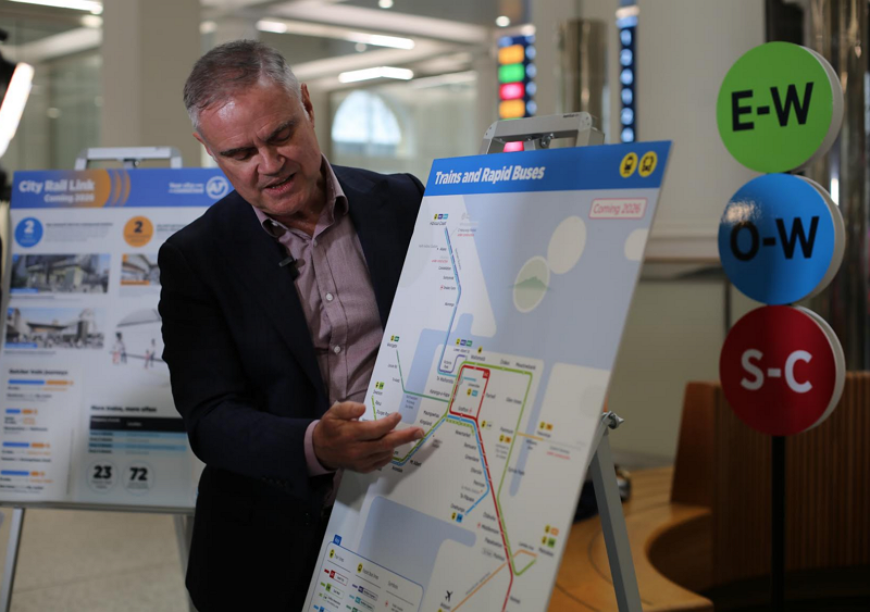
The presser from Stuff
https://www.youtube.com/watch?v=E_Ft-UjMcuM
I walked past that stand up while I was heading for the train to get to my Fix Up Look Sharp appointment, this only occupied my mind for about maybe 5 minutes that day. I think setting up the heater in my sleepout/man cave/soon to be work from home office occupied more of my time.
To be fair, the geographic reality of Auckland makes any easily interpreted map, almost an impossibility.
AT’s current attempt is awful, I know every corner of this city, but that map makes it look more difficult to move, not more easy, as the City Rail Link will actually ensure.
Is this because AT is in the same building as AA. Is this undue influence from the motoring lobby to keep our public transport looking worse than it is, to keep people in their lonely, smelly little boxes with wheels?
I am personally highly distrustful of this relationship. In any serious city, there would be a separate public transport authority to ensure that our public transport served our city. AT serves our citizens, most of our citizens move in private motor vehicles. They cannot change the way we move, because they allow us to move anyway we want.
Cars are a prison on wheels, if we stop marketing them as freedom, then we can all live happily every after in modest apartments, with electric bikes and train stations / bus stops five minutes away.
bah humbug
AT is not in the same building as the AA
20 Viaduct Harbour Avenue contains offices for Auckland Transport, AA and Sky.
For those on Bluesky, a character claims to have examples of some of the *alternative* branding AT considered: https://bsky.app/profile/zhuoyanakl.bsky.social/post/3lvm2h2k4q22c
Oh interesting, and even Jarrett Walker has waded in on the debate.
I’m not a fan of the 2 lettered names. I can only imagine they went with two letters because they couldn’t decide what to call the western/eastern. Otherwise surely one letter is better than two – the S line is much easier to say / write / read than the S-C line. Or they could have gone with colours (which is what will happen unofficially), or any other simple one syllable word.
Surely could’ve just done Crosstown, Southbound and Onehunga as the lines
Although I know Eastern and Western lines don’t really form a traditional “crosstown” line like some proposed mid-isthmus lines I’ve seen on here
It doesn’t start until 2026 so it really is the Future Auckland Rapid Transit. There had to be a fart joke here.
When I first saw the map yesterday I wondered if the S-C line went both ways around the loop. Ie one train from Pukekohe goes via Parnell the next via Grafton. But trying to understand what Matt. L has written I am thinking they will all go via Parnell is that right except some will turn around at Otahuhu rather than going all the way back to Pukekohe. Or maybe we don’t know yet how it will work.
No, you were right the first time. The Red Line goes both clockwise and anticlockwise round the loop.
Thanks so it will be a bit of a lottery as to which way you go around the loop. Except maybe you can switch at Otahuhu if you want to go to Parnell or Grafton. But presumably it wouldn’t be worth it. Just go around the loop.
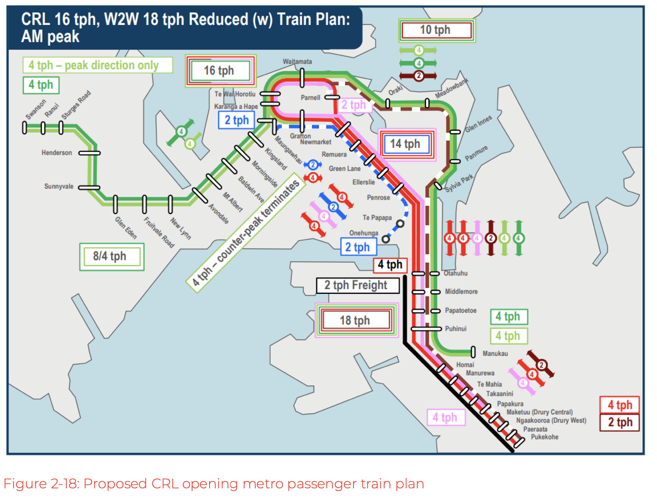
Based on the earlier plans they’ve published, the trains starting at Pukekohe and doing the full southern line will go in via Grafton, around and terminate at Otahuhu, and vice versa. Trains starting at Otahuhu will go in via Parnell, around and out south via Grafton. You can see this most clearly on the “CRL Day One” diagram above.
So if you are heading out south you’ll need to pick the right direction, or make the transfer at Otahuhu. if you are going north of Otahuhu you can go either way.
The earlier concepts showed clearly how the line doubled up between Otahuhu and Newmarket and which part of the line went where. I honestly can’t fathom why they’ve removed this very useful information from the map. Showing where a line goes and what station it ends, isn’t that the most important thing to have on a map?
Anyway the CRL started out as a loop then it became a link and now it’s becoming a hybrid loop/link.
The current tagline from RNZ reporting on the new map: “Maps for the over-budget and over-time City Rail Link were revealed on Monday.”
There’s something seriously wrong with the way RNZ report on transport issues, always negative if it’s to do spending money on active transport (especially cycling). I’ve completely given up on RNZ for this reason, it’s a disgrace.
TBF starting with the negative is how *everyone* talks about transit in this city. Evidence: this blog post, these comments.
No, that’s not fair – it’s how everyone talks about everything these days. We are living through an age of despair and negativity, and with good reasons.
I hope AT reconsiders their older draft naming system. It was simpler, coherent, and even included using te reo for the colour names. The map itself even showed frequent buses in the whole network, not just the BRT routes
Big problem is that the use of Te Reo will start a riot. Have you seen the CRL Facebook group? Every time one of their posts mentions the names of the new stations the entire Jon Reeves/Winston Peters/Hobson’s Pledge crew pile in there yelling about woke Maorification
English-Te Reo would solve that. But I am coming round to the “T1, B3” suggestions…
They all used the T1-3 & B1-5 route codes, but the train lines used the te Reo colours as well, meaning racists have the option of just ignoring it and say T2 instead of Whero (unlike the train stations with solely Māori names)
Done.
That’s funny, I saw some similar comments elsewhere like “Te Wai Horotiu?! how am I supposed to pronounce that mess!”.
Uh, the same way you pronounce Otahuhu, Manurewa, Remuera, Orakei, Takanini, Papakura, Puhinui, Papatoetoe etc etc
Are we going to be allowing high density around Northern Busway stops? Surely inclusion on these maps means they can’t not allow it? Especially as they are still investing money into it via Rosedale station. Time to make the most of the investment.
At first I thought AT’s map was fine, but this article put paid to that notion!
In terms of naming conventions, I think they should adopt colours in a ‘Te Reo – English’ format.
Some people would simply prefer Te Reo colour names, but having it in English would at least dissipate some of the opposition (founded or not) to such a scheme and have the added bonus of practically promoting a (tiny) part of the language by clearly broadcasting their meaning to both non-Maori and foreign tourists.
Perhaps over time we could have a full spectrum network when/if we add more lines in the future. It would be good for me as i’m always forgetting the Te Reo word for ‘blue’.
I like this (as someone massively against them renaming Britomart/Aotea station). Dual name them the colours, and switch up the order every so often so they’re properly equal names.
Aotea was never really renamed, it was just a working name while CRL was being developed.
It’s a station that has never had an English name, although if it did it would likely Wellersley Street or Midtown.
not to mention Aotea is the Te Reo name for Great Barrier Island, and has nothing to do with central Auckland aside from sounding similar to “aorta”.
and Britomart is named after Britomartis, the Greek goddess of mountains, nets, and hunting.
@Burrower
Britomart was because the land was called Point Britomart (https://en.m.wikipedia.org/wiki/Point_Britomart) and had a traditional name with far more relevant history to the site. It should’ve been dual named with that. Aotea because the main station building backs onto Aotea Square, and is a lot better name than midtown (or naming a station at the top of the hill after a waterway at the bottom. That name should’ve been saved for something on Queen St).
Whoever decided to change the names didn’t do much research into the actual station sites and the rich history around them, but just went ‘oh, there is a body of water that was somewhere near there’ and pocketed the money.
@Jezza a working name is still a name. Midtown would’ve been the best name if it needed a dual name (as Wellesley will intersect other transit in the future), but Aotea was a fine name and if it was up to me, Aotea would remain Aotea, Britomart would be dual named Te Rerenga Ora Iti with a few info boards about the sites history.
LMAO
completely ignore the better part of 1000 years of Maori history and names; yep let’s just prioritise the names the colonisers slapped on taken from a british navy ship named after a Greek goddess, and an island 100km out to sea nowhere near midtown Auckland.
Waitematā/Britomart station is right on the harbour waterfront, Te Waihorotiu/Midtown station is next to the (covered) stream running down the Queen St valley. The Te Reo names make sense.
Zero doubt that Te Wai Horotiu will be known as “Midtown” in colloquial usage. And Karanga-A-Hape will be abbreviated as per current.
Shouldn’t the Link buses be on here too?
I think that AT recognises the fact that there’s absolutely nothing rapid about the Link buses.
Yes there’s difference between frequent and rapid some routes are both but most frequent routes have frequency but not speed most of the time
This is the rapid transit network. There’s no reason they couldn’t have a frequent bus map as well that shows connections with the rapid network.
Multiple variations of the map for different purposes is common in many other cities.
No peak service on the Western Line to Grafton / Hospital / Schools or Newmarket!!! That just won’t wash out west.
The Central Rail Link has been marketed as a “Link not a Loop” since 2013 – now it seems it is a link and a loop. Loop services, and services that terminate in a central city, are inherently inefficient as trains run with many passengers in one direction, and hardly any in the other direction. The near universal rapid transit pattern of going from one side of town, through town then out the other side is much more efficient. Over the generations land use patterns evolve based in the availability of rapid transit between various locations. One seat rapid transit is popular with many users.
If the CRL is going to be used as a Loop, the Western line seems a better candidate than the Southern Line. The Southern Line could go from Pukekohe, through the CRL, out the Eastern Line then terminate at Manukau: Nicholas’ Red Line extended to Manukau. It would double up on four stations from Otahuhu to Puhinui which is a little confusing, but not intolerably so. Every service would stop at Newmarket and Grafton / Hospital / Schools.
Making the Western Line a loop line is an enticing prospect. West Aucklanders have been travelling by train to Grafton / Hospital / Schools and Newmarket since 1880, coming up 150 years. Travel patterns that develop over that period of time can’t just be stopped on a dime. To repeat, no peak service on the Western Line to Grafton or Newmarket!! Even if a peak service is introduced later, it will be infrequent and no replacement for a service that has had every train stop at Grafton and Newmarket for nearly 150 years.
If the Western Line ran as a Loop every ten minutes, alternating clockwise and anti-clockwise, with a Newmarket West station rebuilt, it would work.
https://www.nzherald.co.nz/nz/commuter-dismay-at-threat-to-rail-station/S5IGA7PVH4UZJFF2FFCKGLQIFE/
Western Line passengers going to the central city on clockwise services would get a lightning fast service from Maungawhau to Karanga-a-Hape, Te Waihorotiu and Waitemata. If central city bound passengers find themselves on an anti-clockwise service they can either settle in and get to their destination from the other side, or get off at Grafton, walk across the platform and get the next train into the CRL.
Those bound for Grafton or Newmarket on a clockwise service could go round the block, or get off at Karanga-a-Hape, cross the platform and take the next train to Grafton or Newmarket.
You realise that the people who wrote the post think that ANY West->Newmarket trains are a waste of time 😀
Everyone hates this running pattern but for completely opposite reasons
Yes, it all seems to be in the name of network efficiency, rather than catering to a demonstrated need.
I don’t think that’s true Daphne, the last suggested map has literally every single western line train going to Newmarket and the south via the CRL, as well as having faster and more frequent connections between the west and south without going through the CRL.
People usually do not prefer to travel in circles.
One of the absolutely crazy things about the OFF-PEAK only OW service is we have all observed the main use of Grafton and Newmarket Stations to the west are all the school/uni/hospital users. And these mainly occur at peak, so most will be doing this via transfer at Kaianga-a-Hape station anyway. As this is an off-peak service only. So why not make that the all day norm, for legibility if nothing else.
Because, and this is the other crazy thing, then there can be higher frequency on the standard western line pattern off peak, as these OW services take train slots away from the dominant pattern.
Just run the O-Line to Maungawhau all the time. Until western line capacity issues are sorted (level crossings), or, even better, fix the Penrose transfer and run the O-Line as a higher frequency shuttle.
More legible, more efficient. Higher frequency earlier.
Interesting thing on wayfinding. I helped someone lost at Penrose station the other day. They had got off and didn’t know what station they were at. Seems to be no station names at the historic building (and exit) end. Everything else but, she was very confused.
Patrick – have you not been on the Circle Line pub crawl in London? I think it is all Kiwis and Aussies…
The Western line won’t run as a loop until at least the bulk of the level crossings are removed. It simply wouldn’t handle the frequency involved.
– extremely poor transfers between Newmarket West station and the main Newmarket station, in an area that already has poor transfer opportunities to buses
– extra complexity to network, how are passengers going to easily tell whether they’re going on an anticlockwise or clockwise looping service? same problem as the current issue with the Southern & City Line.
– what Patrick says below. As far as stats can tell it is around 1/4 of Western Line passengers who are headed to Grafton and Newmarket; not deserving of half of all Western Line trains post-CRL.
low frequency one seat rides are NOT optimal transit design, transfers between ultra-high frequency lines ARE. why else do you think all-new metros avoid interlining and overlapping routes.
i don’t know why all you oldie transit types are so fussy about one seat rides yet happy to increase waiting times at stations, or subject some passengers to longer journeys so you can have your “one seat ride” everywhere. Very hypocritical. A transfer between two lines that run every 7 minutes with a timetabled connection will be quicker on average than a “single seat ride” that runs only every 20 minutes.
and oh gee, i wonder why people switched from ferries to driving to the North Shore on a dime when the AHB was built. You may not be flexible, but most people are quick to adapt to changes in transport routings.
All Red, Green and Blue services would go through Newmarket West so there would be no need to transfer between Newmarket West and Newmarket Stations. Good bus transfers can be established between stops on Broadway and Khyber Pass Road and the Newmarket West Station.
Station announcements and platform and train signage indicates to passengers which train is approaching the station.
¼ of passengers heading for Grafton and Newmarket well justifies the 50-50 split of clockwise and anti-clockwise services on the Western Line.
High frequency services that provide excellent one seat rides and high transfer opportunities is optimal transit design.
A one seat ride every seven minutes is quicker every time than a journey requiring a transfer between services that run every seven minutes.
People adapt their land use patterns in response to the provision of excellent rapid transit with long term stability i.e. many decades.
– So you’d have both a Henderson-Onehunga service *and* this split loop Western Line? Seems excessive
– Both Newmarket West and Newmarket stations? do you oldies not understand that stations just a few hundred metres apart negates any speed advantage heavy rail may have
– No it doesn’t, the math doesn’t check out. You want a 3:1 ratio of Western Line trains headed to & from the CRL to crosstown trains headed to & from Newmarket.
– One seat rides should not be the priority where there is not enough demand to justify it
– You don’t seem to have any awareness of rail capacity. One seat rides everywhere means you wouldn’t be able to fit 8-9 trains per hour on every service. It’s a choice between transfers between 7 min frequency service and one-seat ride services at 15-20 minute frequencies. You cant have your cake and eat it too.
– So your solution is to only make incremental changes so as not to rock the boat, while the world and the damage we’ve done to it moves on? Well done, mate. Some changes of travel and land use patterns need to be forced.
Onehunga to Manugawhau would be sufficient.
If there is cause for it, there is no problem having some closely spaced stations in a rapid transit system. It has never been up to date thinking to not make the most of available infrastructure and opportunities.
Alternating services provides the required capacity and a consistent choice of destination i.e. if the train coming isn’t the right one, the great majority of the time the next train will be.
One seat rides are part of all transit systems. The utility of one seat rides and the utility of services that need a transfer both have to be maximised.
One seat rides can be every seven minutes which provides excellent one seat rides and a frequent enough service to allow transfers.
Optimising available infrastructure and opportunities does not prevent future developments.
The western line has been re-routed just as the East Coast Main Trunk was 50 years ago. It made it harder to get a train to Paeroa and Katikati, but the benefits far outweighed those losses.
Looking at that map really makes me wish Auckland Light Rail was still on the cards ;_;
Yeah is the big fat obvious glaring deficiency in the RTN map.
LRT aside, add a completed Airport to Botany, an Avondale-Southdown RTN route and BRT from Constellation to the NW Busway……and its not bad coverage.
Overlay with the frequent bus routes on the major corridors, plus the ferries. Slowly but surely we are getting there…
If they did Avondale-Hillsborough, then they wouldn’t need the peak avoidance of the Western line as long as they grade separated to Avondale. That might be the majority of the separation needed anyway, I am not sure.
ASL will never happen, redundant relic of the steam era.
It doesn’t even do what it says it does (bypass the western line).
It has no metro purpose, diverting trains from the west would reduce capacity on the inner west.
Transit is designed by service pattern first and infra last. This is being planned as a semi useful freight line (and then only if NorthPort actually happens), then trying to shoehorn some sort of pax use onto it.
While also saying -we need to separate pax and freight, they’re flogging this as a mixed line.
So much that’s way more urgent:
AKL Level crossing removal
Quad Papakura to Westfield, at least triple the Eastern line
Batt/OHL Bimode intercity train sets, including to Tauranga
Marsden link
Electrify the ECM and the Puke-Te Rapa gap
Double Whangamarino and Ngāruawāhia
Double North-south junction
ETCS Wellington
ETCS-2 AKL
What about BRT down SH 20 to Onehunga and then onto the airport?
Hi Patrick, regarding your comment about ASL not happening, I would be fine with that. But that leaves people where the Owairaka / Mt Roskill stations should be, not having access to any Rapid Transport links. What is the appetite of Auckland Council / AT to instead build the Mount Roskill spur line? The motorway exits have already been built to cater for a rail line, so it would minimize the cost. It’s a quick-win.
There’s no simple solution with the network Auckland has but this appears to deliver some impressive frequency between Newmarket and Otahuhu but not as much on the Eastern line.
With the Eastern busway coming online at a similar time I think it will be the Eastern line that really needs the extra capacity.
I’m pretty sure they’ve canned the stopping at Otahuhu and are just gonna alternate directions through loop?
Interesting, that would be a significant drop in frequency through the CRL from day one compared with what was previously planned. It might explain the article from Orsman a few months ago which talked about a reduction in peak capacity compared with what was originally planned.
In contrast, what Peter Reidy talked about in this op-ed on the same day if it starts happening anytime soon way more exciting
Picked paywall lock link because friends don’t let friends pay for The Hearld
https://archive.is/nQsdO
Thanks for the link. Is this just Mr Reidy pitching to his bosses (who no doubt read the Herald) or real things coming?
Thats what it read like.
Its got no funding and no priority (its only planned to be running in 30yrs time).
As KLK said, no confirmed funding for any of it hence the “if it starts happening anytime soon” so yes a pitch to the government if successful truly exciting stuff
I think he’s playing the long game. There’s little chance with the current government but it’s likely we’ll have a centre-left government before the decade is out.
Having something ready to go is a good plan.
If the S-C trains from Pukekohe only went anticlockwise around the loop ie via Parnell then Otahuhu trains could go clockwise around it ie via Grafton. Then maybe the Onehunga trains could also go clockwise every 30 mins interspersed with the Otahuhu ones.
And what about people from Pukekohe, or anywhere south of Ōtāhuhu, who wanted to get to Grafton, Karanga-a-hape and Midtown quicker than they did to Waitematā or Parnell?
Transfer – is quicker than waiting 10 minutes for the next train and a one seat ride.
I would think transfer at Newmarket. But anyway I am thinking of the students who get off at Parnell. I was a little surprised how many do. But anyway there doesn’t seem to be any running pattern that jumps out as being obvious. Take the 70 bus more stay on than get off at Panmure mostly students I would have thought. I wonder if that will change. Anyway things will settle down and clearer patterns will emerge. Then At will know what tweaks to make.
Is there any reason why AT couldn’t just invite the team from Greater Auckland to comment on plans such as this before they are made public? It seems like a no-brainer to me, especially if it was done right with NDAs being agreed.
+1000
i think we should open the betting books on how long the new titles EW, SC and – damn, I’ve forgotten the third one already – how long they last before they get “rebranded” as either poetic Māori names, or as pragmatic Colour names in either te reo Māori (whero, kākāriki, pūru) or te reo Pākeha (ie Red, Green, or Blue). I give it max one year. Any takers?
I agree with the criticisms but it is disappointing that GA continues to support / promote the alternative that is not operationally feasible (at least unless limited to woefully infrequent service on the Eastern line, right when the Eastern Busway comes online). There has been previous discussion about that. Is there a feasible alternative that everyone can get behind?
Reposting from November:
I agree entirely with the sentiment (legibility), but unfortunately it is highly unlikely that the proposed operating pattern would be operationally feasible or provide sufficient frequency or capacity on the Eastern line, including at the busway transfer at Panmure.
With only one terminating platform at Otahuhu, and one approach track from Westfield junction to Otahuhu, frequency on the Eastern line would be limited to 15mins at best, and I highly doubt the preferred 7-8min frequency could be achieved, at least without extremely delicate timetabling with zero contingency.
In contrast, the inner southern stations would be massively over-served, and conflicting movements at Newmarket would be very complex.
Far preferable, in my opinion, would be to keep Swanson to Manakau via CRL, and if necessary to terminate Southern Line trains back at Newmarket (after travelling via Grafton, CRL and Parnell) if one really wanted to avoid the double back to Otahuhu for legibility reasons.
That would run into similar frequency and capacity constraints as the single terminating platform at Otahuhu (i.e. limiting frequency to up to every 15mins). However, peak overlay services could terminate at Quay Park without losing much legibility, and the combined frequency back to Newmarket from the CRL would in any event automatically be double that. All conflicting movements at Newmarket would be eliminated.
That would also free up the inner south stations for 2tph Onehunga to Maungawhau, thereby also ensuring the Maungawhau Western line platforms are used on Day 1.
Can anybody identify any issues with this arrangement? I would be extremely grateful if somebody could depict it as an alternative version of the map!
Rivers, the proposal above has exactly the same number of trains running via the east and the south, and the same number of trains starting and ending at Otahuhu. If the inner southern stations are overserved they will be in either case, likewise the Newmarket junction being overcapacity or not.
But I don’t think they are, because the capacity will be used by passengers starting trips much further south from Manukau, Papakura or Pukekohe onwards.
The main difference for the east is that there will be more capacity at Panmure, because the eastern trains would start empty at Otahuhu, two stations away , and have most of the space onboard still available at Panmure. (rather than starting six stations away at Manukau and being mostly full by the time they get to Panmure). Giving more capacity to the eastern busway transfers is the whole point of that part of the suggestion.
Thats the base pattern, at peak some of the extra frequency layered in might also start at Manukau, for example the peak only ones that terminate at Newmarket.
Routinely terminating a main line at Newmarket is problematic because it also means starting a main line at Newmarket… which means in the morning you’ll have a large fraction of the peak trains in the CRL starting empty just outside the city, taking up space in the CRL to run outbound, and in the evening youll have about a quarter of the trains passing through the CRL terminating just after leaving it. Effectively if you don’t take those trains to or from the suburbs you’ll end up with a stack of peak capacity used up on empty, or almost empty, trains.
Thanks Nick.
Agree that regular Newmarket terminators are not ideal. I had suggested that in response to previous concerns about legibility. I can live with (and indeed would prefer) all Southerns doubling back, alternating directions around CRL, per what AT now seems to propose. Not perfect, but I have yet to see a better proposal.
Re East, can see the capacity point for the services that do run, but the fact remains that even 15min frequencies would be very challenging with no redundancy, let alone any improvement on that. We can’t have a Day 1 operating system where ANY improvement to base all-day frequencies from 15mins requires a total network redesign.
It wouldn’t be only 15 mins at peak, that map is just the base all day network. It would be eight trains an hour at peak, plus possibly the express from Pukekohe. Some of those extra peakers might have to start and end at Manukau, which is no problem, it simply takes the line further.
No need for a total network redesign to extend lines or add frequency, not sure what you mean there.
Errr, these no difference in frequency on the eastern line between either plan.
Yes, but:
1. On Nick’s proposal, I’m not sure even 15min frequencies would be possible on the East; and
2. Certainly no better than that would be possible.
My proposal, amended as above, would have flexibility for increases across the network (think, eg, 10 min weekend frequencies on both lines).
If any future Henderson – Maungawhau slots were successfully repurposed as additional West-East slots, as they should be, then with the same total TPH out West, it would support:
– 8tph West – East
– 8tph South – City (alternating CRL direction).
– 2tph Onehunga – Mangawhau.
Simple, efficient, legible.
It would be eight trains an hour on the east, four regular all day, plus four peak direction additionals for capacity. Exactly the same as the “day one” plan shown above.
Ya know…. I think it’s not as bad as some of y’all are making it out to be. You all have a habit of jumping on something to beat the crap out of it because “you think you know better than the actual transport planners who have live statistics and spend their lives researching these things”. Or something like that. Obviously it’s not gonna be perfect, but look at how much our network has improved since 2010! 15 years and it may as well be a completely new system it’s night and day! Once the western line is grade separated and we have the eastern + northwestern busways completed, our public transport network will be FANTASTIC! Obviously light rail would be better but we take what we can afford!!! Can’t wait WOOOHOOOO!
This is indeed a tendency. Just look at how misguided the blog looks in the wake of the disastrous Medium Density Residential Standards (which have failed to address Auckland’s sprawl, are drastically increased Auckland’s flooding issues and have depressed the market for quality apartments in favour of poorly built, apportioned and appointed town-houses).
This is on the whole an excellent – and much needed – publication that has had a positive impact on Auckland transport planning; however like anything; reader discretion is advised (i.e. don’t believe everything you read).
So….we don’t even know where the Southern line will run to/from and which way round the loop it’ll go?
Wat?
From AT: “Kia Ora John, The South City line will alternate between Clockwise and Anti Clockwise when travelling on the city loop part of the journey. Nga Mihi ^KH.”
As in my comment above IMO if one line has to loop, alternately clockwise and anti clockwise, better to do it with the Western Line as it would give alternating direct access to Grafton / Schools / Hospital and Newmarket West, and more frequent transfers from Karanga-a-Hape to Grafton and Newmarket West.
What about Auckland’s Northern areas – Wellsford, Warkworth, Snells Beach, Matakana etc. They all have AT buses that connect with the southern areas. There be a “Northern” section added to the map.
I think I’ll be calling them the Green, Blue, Red and Yellow lines
I think the naming conventions for the train lines work well for those that know the existing system & geography, but I’d rather have simple A, B, C and the colours that go with them. If you use numbers it can get confused with platform numbers. In saying that I don’t hate the more descriptive ones. Could be useful.
Grant, exactly, this is it. They are facing backwards at the very moment of the biggest transformation of the system. Reading that briefing paper it is all about current users. There is clearly a complete lack of vision in the governance of AT. If elected I will fix this.
Yes, I haven’t read enough of that test user group etc document yet (“,,,Auckland Transport_Navigating the Network…”) to know whether they were “new” users or not so wasn’t sure.
CRL soon opening in with station located in K RD. Spending slumps 22% on Auckland’s K Rd. Council data shows card spending on K Rd dropped 22.5% between April/May 2024 and the same period this year.The disruption started with the $30 million “Karangahape Rd Enhancement” project, which took several years and included a cycleway and rainbow-coloured overbridge; there has been the furore over removing curb-side car parks in late 2023, and Project K to upgrade streets around the City Rail Link.Handmade crafts and furniture store Buana Satu for 34 years, the owner says she’s never seen a winter this bad and this is the “worst year”. Buana Satu owner and others store owners cite parking issues and anti-social behaviour as major concerns affecting trade but also years of the “digging up the street and the noise from the roads, no car parks and a rise in anti-social behaviour”. Handmade crafts and furniture store Buana Satu In the big basement below her shop, heaps of new and old stock, old fabrics, and bits and pieces sell well when there’s a movie being made in Auckland. But McIntyre said it was the first time in years when there hadn’t been any film work. “People want to come here, grab a bite, do some shopping, not pay $20 to $30 to park.” She points to Wilson’s parking on nearby Cross St. “It’s awful and expensive. People just go somewhere else. People don’t have the luxury of money or time,”
She continues to add “I’ve had soo many of my customers coming into the shop say we’ve been driving for about 20 mins trying to find a carpark and we(customer) just drove home cause we couldn’t find a carpark!”
Owner of Paperbag Princess, a recycled clothing store says the new Western Express bus service hasn’t brought the foot traffic many business located in K road hoped for! Most items in Paperbag Princess are priced between $18 and $20, but even that can be a stretch for some customers they claim!
General manager of the K Rd Business Association, is the street’s unofficial cheerleader cites K Rd business trading had dropped starting from last winter but not gaining much traction! “In the middle of last winter, we noticed a real sharp downturn in people spending less at restaurants basically and June-July 2024 has been really-really slow clawing our way back. Not fully back yet! ” Also cited Parnell and Ponsonby had similar declines in June-July 2024.
https://www.nzherald.co.nz/nz/auckland/spending-slumps-22-on-aucklands-k-rd-businesses-pin-hopes-on-city-rail-link-opening-next-year/KGM57T3DTZDWHJHKXQVNF3GV6I/
If Auckland was to build another ‘K RD’ in-future, with a rail corridor underneath a roading corridor with linking with a rail stations, Busways(later in future bi-articulated buses) and Heavy Rail corridors are future for Auckland’s growth and connectivity! Only PT modes needed for Auckland. Light tram would be blocking one side of road from private vehicles from doing 180 turns meaning only both bus and private vehicle can share road not light tram. What Auckland shouldn’t be seeing Queen ST main roaring corridor converted to walkway/light tram corridor. It becomes attractive place to bring crime such as ram raids, petty crime and anti social behaviour, negatively impacts businesses in CBD. Exactly what’s happening in Sydney! Sydney’s George ST converted into light tram tracks and no road users on the corridor light tram serves in CBD area. Filled with buskers and homeless people on the streets, Auckland shouldn’t be following the same lead!
Auckland shouldn’t be adding more ‘vanity vehicle collection items’ such as ‘modified light tram’ or train-tram or any such vehicles just to present at an exhibition like MOTAT just to show off a new vehicle! NO! It’s not serving the needs of everyday Aucklander’s by exhibition display for future generations! Dominion RD could become like mix of ‘K RD’ and ‘Remuera’ and become a Heavy Rail corridor so can do orbit around Auckland’s CBD! We’ll be going back to 2022’s heavy rail timetable once CRL is up and running and doesn’t make sense into why EAST-WEST line during peak will run into Newmarket from Manukau to terminate! Dominion RD in-future needs stores like Buana Satu & Paperbag Princess unique small business like stores and also needs a Heavy Rail corridor! But it needs to be done properly with working with businesses located in corridor!
Yawn. Anon proving once again their true colours: they’re an old fuddy duddy devotee of car dependency who doesn’t care about the environment or better outcomes for society, cities, and people.
The sudden switch to b1tching about homeless people and trying to tie carparking to business productivity is VERY telling
“devotee of car dependency who doesn’t care about the environment or better outcomes for society, cities, and people.”
Car dependency who doesn’t care about the environment?! Um what?!!!! You’re still stuck in 2020-2000s era, we’re now changing to electric vehicles which don’t emit toxic chemicals into the air era now! Electric vehicles has no negative effect on the environment! Parking curb sided on K RD would benefit businesses like Paperbag Princess & Buana Satu by providing upfront shop parking to serve customers! That definitely creates better outcomes for society, Auckland’s economy, and people!
entirely forgetting about tyre particulate pollution there, bub. or the mining resources for batteries. Total fuddy-duddy wishful thinking to claim they “solve all environmental problems” especially when the government is still enslaved to the fossil fuel industry
And what about the provable correlation between the rise in use of cars and the rise in obesity and other health concerns? Why are you so against people walking more as part of their getting around? Shame on you for not supporting better health outcomes
This isn’t about car dependancy, this is about how we get ‘best of both worlds’ by having option of curb-side car parking and PT for K RD. Many high disposable customers who don’t have the time for PT need store upfront curb-side car parking to help these small businesses thrive. Otherwise the small businesses lose customers.
K’RD doesn’t have any curb-side car parking which is killing small business!
“don’t have the time for PT” gee i wonder how we could do that… how can we make public transport more convenient with less waiting… by any chance might it be the convenience of high frequency service (better than every 10 minutes) so that people can go catch a bus, tram, or train anytime, never having to worry about timetables, just as easy as choosing to drive somewhere anytime they want?
Gee I bet a lot of European cities that have pedestrianised their inner cities and had roaring business will be surprised by your cager assertion that carparks are necessary for business. I guess us Kiwis are a bunch of weak wimps.
And of course your type of transit “advocate” wouldn’t understand that you can’t have your cake and eat it too. Space needs to be reallocated from cars to more productive purposes; transit-only lanes that move more people; outdoor eating areas or pop-up parklets or market stalls that earn more money and are better looking with potted plants than tarmac and parked cars.
Though I mean, since you’re thick enough to be okay with ploughing through Christchurch suburbs to build a motorway-speed busway, safety barriers and sound barriers and everything, but treat a kerb protected bus lane/light rail medians along dense corridors as this horrible oppressive thing… I guess I’m talking to a brick wall.
This is a chance for the central government to add a Dominion RD Heavy Rail corridor so it can do an orbit around Auckland CBD! CRL is opening soon, with station located in K RD. The new Western Express bus service hasn’t brought the foot traffic many business located in K road hoped for! Opening of the CRL since it running on mainline freight/PT rail corridors will definitely bring new catchment of customers into K RD and gain new regular customers. Same would be said if Dominion RD Heavy Rail corridor existed and exactly why it needs to be built! CRL let alone won’t be enough to help K RD, it’ll definitely need a Dominion RD Heavy Rail corridor and once Dominion RD ?Heavy Rail corridor built it’ll bring K RD flourishing with enough customers for K RD’s small businesses!
Parnell and Ponsonby are going to continue to decline in sales trading due to no new catchment of Heavy rail corridors that get customers directly to Parnell and Ponsonby
Dominion RD should become like mix of ‘K RD’ and ‘Remuera’, turn Dominion RD a boutique/authentic small businesses district for high disposable income. Dominion RD should become a Heavy Rail corridor so can do orbit around Auckland’s CBD. Doesn’t make sense into why EAST-WEST line during peak will run into Newmarket from Manukau to terminate, you may as-well get on with constructing an Dominion RD Heavy Rail line!
you are not going to be able to run your heavy rail trains at 110kph when there’s 800-1000m station spacing. it is physically impossible per the acceleration and deceleration performance of the AM class electric multiple units. There is in fact NO benefit to going any faster than 60kph with stations that close together.
The place for heavy rail is the longer corridors like the Southern and Western Lines, with station spacings over 1.5-2km. That’s where you can use speed. And Dominion Road just isn’t that sort of corridor, bub. the mode just isn’t going to provide any speed, capacity, or convenience benefits with your nonsense idea.
Even if stations was 800 m to 1 km apart, Heavy Rail would capability travel accelerate to 110 km/h with early gentle deceleration meaning gets to every station within 1 mins regardless without the current imposed speed restrictions on Auckland heavy rail network just like speedy Singapore rail network would. Tracks not on any aging rock foundations under the tracks.
Delusional. Utterly detached from reality.
110k/hr between stops 1km apart? That includes acceleration and deceleration? You’ll be at the next stop (and past it) by the time you get to anywhere near that speed.
Its not possible and not necessary.
Average speed of the Western Line is just under 30km p/hr. The London Tube a little above that. I have heard Singapore runs at 60k p/hr on average but thats probably enabled to by station spacing and newer tech. I haven’t heard of anything above that for an urban system. You are proposing almost twice that speed.
For areas out of a city center, e.g. regional, with large gaps between stations, sure. But that’s not Dom Rd.
You have been flogging your HR preference for a while now on a route which is not appropriate. You should try reading the feedback you get and either change your mode of rail or choose another corridor.
i’ve tried directing Anon to the article on station spacing about the acceleration/deceleration graphs of the Auckland EMUs, that literally shows a train would just get to 80km/h before it had to slow down between stations 800m apart
but they’re either incredibly stubborn, unintelligent, or have some sort of mental condition
like it’s basic physics, it should be common sense to know that nothing can accelerate from standing still immediately to maximum speed. and anyone who’s actually caught Auckland trains recently knows they’re probably not reaching anywhere near 110km/h at any point on the network.
Funny how the HR cultists always assume the best possible travel times and lowest costs for their mode, and the worst case scenarios for anything they don’t like. i’ve shown Anon video of light rail travelling at ~80km/h, and they still insist the only possible type of light rail is a 30km/h MOTAT tram with bus stop station spacing.
West to Newmarket is a daily commute for my daughter and a few other students to get to school during term times so direct routes are appreciated.
A lovely map isn’t going to be much use if the trains hibernate over Christmas and new years, and I hope they extend running time on weekends to 1 or two so fun nights out on the town make sense….