Transport Minister Chris Bishop was on a project announcement spree last week. As well as the Northwest Busway which I covered on Thursday, he also announced updates on three Roads of National (party) Significance in the Upper North Island.
A couple of things that stands out from these:
- From ones that have costs listed, is that construction cost inflation is massive and at $5.5 billion, the City Rail Link is starting to look like even better value.
- Changes to the economic assessment of projects, such as last year lowering the discount rate to 2% (and less) and using longer assessment periods out to 60 years, means the BCRs look a lot better than they would have just a few years ago. By comparison, the CRL was assessed with a 6% discount rate for 40 years.
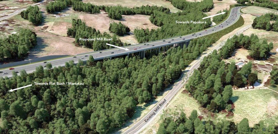
Mill Rd
The Minister ended his week with Mill Rd. The project has a long history, starting out life back in 2009 by the former Manukau City Council and was carried on by Auckland Transport project, who confirmed a designation in 2016 for the section between Manukau and Alfriston. In early 2020 the project shifted to Waka Kotahi after Labour included it in its NZ Upgrade programme but notably it was for the entire corridor all the way from Manukau to Drury. A year and a half later the project was scaled back again after costs blew out from $1.354 billion to $3.5 billion and the focus shifted back to that original section and targeted safety improvements on the rest of the corridor.
The project has a lot of support from land bankers and developers in the area and National included the full project in its new Roads of National Significance programme but the focus has been on that original section as the work done already means it can be started sooner.
Transport Minister Chris Bishop has welcomed the NZ Transport Agency (NZTA) Board’s endorsement of the investment case for Stage One of Mill Road, a crucial Road of National Significance.
The Board has endorsed the investment case and approved $91.1 million for completing the design work and securing consents on Stage One.
“South Auckland is the fastest growing area in the Auckland region, with 120,000 more people expected to make it their home over the next 30 years. We need to get on and deliver crucial transport infrastructure that supports that kind of growth, reduces congestion, improves safety, and helps unlock housing,” Mr Bishop says.
“Mill Road is one of 17 Roads of National Significance (RoNS) this Government is progressing, and the NZTA Board’s endorsement of the investment case and approval of design and consent funding for Stage 1 is a direct result of our focus to streamline the business case process and get projects into delivery faster.
The investment case for Mill Road Stage 1 (Manukau to Alfriston) includes:
- Four lane (general traffic) corridor including a westbound bus lane at the northern end.
- Two new and six upgraded intersections between SH1 interchange and Murphys Road.
- Three new roundabouts.
- New bridges across Puhinui Creek and Cheesman’s Bush.
- Current Mill Road south of Redoubt Road becomes a shared path and property access road.
“Delivering Mill Road Stage 1 has substantial benefits, including a 30 percent reduction in congestion on the corridor, over 60 percent reduction in deaths and serious injuries, and by 2031, 25 percent faster journey times.
“The endorsement of the investment case and approval of design and consent funding for Stage 1 provides certainty on the next steps as the project moves to complete the design and technical work necessary for construction to begin as early as mid-2026.
It’s interesting to see that the project will still have at-grade intersections as this doesn’t conform to the Government Policy Statement that states “All Roads of National Significance will be four-laned, grade-separated highways“.
What’s concerning is that this stage alone is now expected to cost $1.75-2.05 billion. I hate to think what the remaining sections will cost.

“The plan is to focus on Stage 1b from Hollyford Drive to Hilltop Road, along with a piece of work to the south (Stage 1d), which includes roundabout improvements around the Mill Road Alfriston area. Stage 1a between State Highway 1 (SH1) and Hollyford Drive and Stage 1c from Hilltop Road to north of Alfriston will be delivered later.
NZTA suggest Stage 1 will take till around 2033 to compete mid-next year the planning/design focus will shift to the other parts of the corridor.
This image of AT’s plans from back around 2015
There is also the potential that at least parts of the corridor will be tolled, with the announcement stating
“The Government Policy Statement on Land Transport 2024 (GPS) also requires NZTA to consider tolling for all new RoNS. The investment case confirms tolling is possible and the revenue will support the construction and maintenance of the road. If tolled, Mill Road Stage 1 has a Benefit Cost Ratio (BCR) of 2.2, and un-tolled the BCR is 3.1. The Government will consider this recommendation and announce next steps of the process in due course.
Northern Expressway
A day earlier, the same day as the Northwest Busway announcement, he also made an announcement in Northland about their plans for an expressway from Auckland to Whangarei.
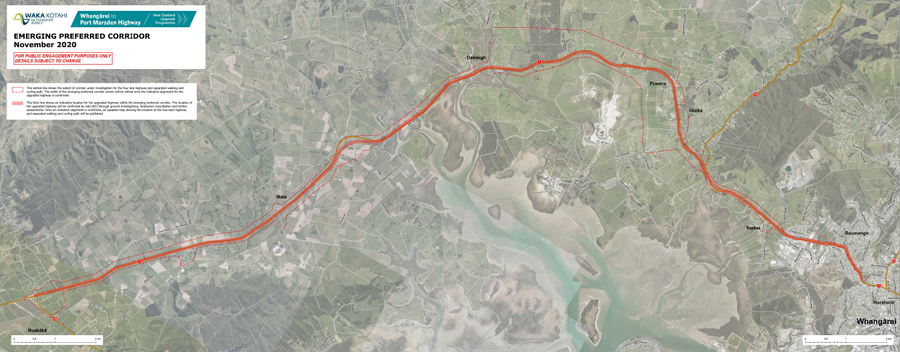
The $4 billion section between Warkworth and Te Hana is already consented and the NZTA has started procurement for it. The big announcement was the ’emerging preferred corridor’ north of Te Hana.
“Today NZTA is announcing the emerging preferred corridor from Te Hana to Whangārei, which will deliver a new four-lane, mainly grade-separated route that bypasses key pressure points on the current State Highway 1 (SH1).
“For Section 2, Te Hana to Port Marsden Highway, the emerging preferred corridor is a new route to the east of SH1 between Te Hana and the Brynderwyn Hills, near to the east of SH1 at the Brynderwyn Hills and to the west of SH1 between the Brynderwyn Hills and Port Marsden Highway.
“The Brynderwyn Hills is a very challenging section due to the steepness of terrain and quality of the geology. Alternative options in this location looked at western routes but following further investigation, NZTA has reassessed and found a near east alignment close to SH1. This is a more direct route with more predictable geology that can be managed through engineering design.
“For Section 3, Port Marsden Highway to Whangārei, the emerging preferred corridor is a new road near SH1 between Port Marsden Highway and State Highway 15 Loop Road and a widened SH1 corridor approaching urban Whangārei,” Mr Bishop says.

Previous options had a bypass of the Brynderwyn’s west the existing road (below) so now going to the east is a notable change. However, the problem remains just how a road of this scale can be justified. Warkworth to Te Hana is around 26km and is now costing around $4 billion. Whangarei to Port Marsden is around 15km and was last estimated to cost about $1.6 billion. Between Te Hana and Port Marsden is around 42km with some obviously pretty tricky terrain so is going to be very expensive, yet it only carries just over 10,000 vehicles a day.
My guess is spending even a fraction of what this expressway will cost on further resilience upgrades for SH1 as well as a range of safety improvements, curve easements and passing lanes all over Northland would deliver far more benefits for Northland (and the country) than what this project ever will.
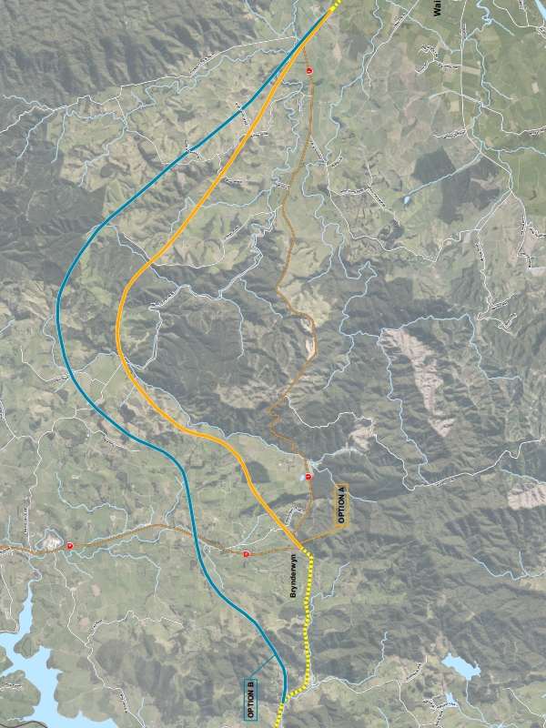
Previous Brynderwyn’s bypass options
The Port Marsden to Whangarei preferred corridor has been known for a long time.
Tauriko West
Finally, in the first announcement of his week was yet another highway for Tauranga, the $2.8-3 Tauriko West highway ugpgrades.
The NZTA Board has endorsed the investment case for the new Tauriko West Road of National Significance, consisting of:
- A 4-lane offline SH29 from Redwood Interchange to Takitimu North Link Interchange, designed to accommodate speeds of 110km/h
- Widening existing SH29A from Takitimu Drive Toll Road to Barkes Corner
- 7 intersection upgrades, including 3 new interchanges and 2 overbridges
- Current SH29 to become a local road
- Board support for consideration of tolling subject to Ministerial confirmation.
The NZTA Board has also approved $97.2 million in funding for route protection.
“As part of the SH29 Tauriko West RONS, a new SH29 will be built and SH29A widened to support economic growth, productivity, commercial and residential development, protect the strategic freight route, and improve resilience and reliability, and safety for all users,” Mr Bishop says.
“These upgrades will support the Tauriko Business Estate extension and enable the potential development of 30,000 new houses in the Western Corridor by 2063. Other benefits of the project include a 40 per cent improvement in travel time reliability, 13 min reduction on SH29 and 6 min reduction on SH29A, and a projected 50 per cent reduction in deaths and serious injuries.”
…..
The Tauriko West project will be delivered in four phases:
Phase 1: Ōmanawa Bridge replacement (SH29) – The replacement of the Ōmanawa Bridge, realignment of the connections on SH29 around the bridge and minor improvements to the Ōmanawa Road Intersection. Construction is expected to start later this year.
Phase 2: Route protection for SH29 and SH29A – Designating, consenting and progressing property acquisition so NZTA is ready to proceed with the detailed design and construction when funding is made available. This also protects the route from being built out in the upcoming development of the area.
Phase 3: SH29 offline – Constructing a new 4-lane SH29 from north of Ōmanawa Bridge to connect to Takitimu North Link Interchange including Takitimu Drive Toll Road, and revocation of the existing SH29 (indicative design and construction timeframe, subject to funding).
Phase 4: Widening existing SH29A – From Takitimu Drive Toll Road to Barkes Corner and a new interchange at Barkes Corner.

Tauranga is quickly becoming more highway than city.
This post, like all our work, is brought to you by the Greater Auckland crew and made possible by generous donations from our readers and fans. If you’d like to support our work, you can join our circle of supporters here, or support us on Substack!

 Processing...
What stands out with this as with the NW busway is how the early work is going to be relatively minor, while the can has been kicked down the road on the serious stuff.
There’s every chance that if this government doesn’t get a 2nd term, or even if it does, a lot of this won’t proceed.
NW busway could have been done when motorway was extended to Brigham creek. They knew they were going to allow unbridled growth on area. H16 has more traffic movement than transmission gully. and we are meant to he greatful.
Or blame an incoming “anti-car” government for defunding their RONS in favour of accelerating NW bus way
The incoming govt cd hv built the bus way when they did the motorway extention. They knew the growth being pushed on the area
National will get a second term. Even if Labour manages to lift their game the Greens will say something daft that will scare the swing voters back to National. National will have to become as dysfunctional as the last Labour government to lose.
That’s my gut feel too, but I’d be very surprised if they get a 3rd term.
The big unknown is which way Winston will go, his bargaining power is a lot stronger now than it was in 2023.
There’s a whole generation coming through that will remember the school lunches and also the current voter age group will remember the treaty bill. This from the man whose party only exists because of a quirky electorate that shouldn’t have so much sway. He shouldn’t even be a politician.
Profligacy.
At this point they should just become an ad company for Turners – Cars, Cars, Cars
Look, I still see a shared path (AKA “gold plated cycle infrastructure”) in those plans for Mill Road, I think. Gotta leave something to value engineer away later.
The Northern Expressway seems like a terrible investment for the NZ public – as noted they’d be better off spending less to augment the existing route and bypass the main choke points i.e. Wellsford and Te Hana etc.; even when traffic is at holiday worst (far beyond the usual load for commercial traffic) outside of these choke points the traffic is essentially free flowing.
How this hasn’t got more attention in other parts of the country, which are not getting even a fraction of this money spent on their infrastructure surprises me.
The Studio for 1 News and 3 News is in Auckland. Any issues in the South are pretty much ignored.
Well it has 40% of New Zealand’s population and more than that fore road use stats. Perfectly reasonable focus.
Ad, this very blog has published articles on the road use numbers for Auckland – Whangarei traffic and it does not justify the spend without some frankly delusional projections for growth in the region. The volume doesn’t justify it now or in the future, better to spend less on bypassing the choke points and building resilience where it’s needed along the route.
The road between Wellsford and the Marsden Pt turn off carries around 10,000 vpd. The road between Cromwell and Alexandra carries around 7000 vpd.
It is more but it doesn’t in anyway justify turning one into a motorway and leaving the other exactly as it is with no median barrier.
Wellsford has 13,000 vpd, Inglewood has 12,000 vpd. One is in line to get a full motorway bypass, the other doesn’t even have a bypass in the pipeline.
Phil, half the point of a good road north is to induce demand. It’s the poorest region of New Zealand, with 1.7m customers and NZ’s only major international airport down the road who find it takes too long to get there.
So Northland stays poor until you build access. You should have seen it when I was a child in the 1970s.
The other half is to withstand a massive climate crisis with something that will last.
Neither are well accounted for in in a business case gateway process.
So you are suggesting the Northland will become ‘rich’ if they get 4 lanes and save 15 minutes travel time…you been helping out on those BCR’s?
Joe I am certainly suggesting that they would be better off than they are now. I hope you’ve been there to see the rural squalor and degradation and economic stasis that exists there now. At the moment Monganui-Cable Bay, Kerikeri, and the Karikari resorts are little isolated islands of prosperity in an otherwise super-high deprivation region.
We need Whangarei with 250,000 people and spread from Waipu Cove to the Heads. And you can do that if you make it 1 hour 50 to Whangarei on a decent and reliable highway.
“The project has a lot of support from land bankers and developers” aka Party Donors.
A far bigger consideration then those pesky BCR’s that the calculation method constantly needs to be manipulated to give a desired result.
“How a road of this size can be justified” well it’s simple don’t justify it just build it anyway problem solved.
The amount of money wasted on planning/scoping projects that are cancelled when the next admin rolls in is outrageous (as many of these will be).
How can we have a bipartisan approach that prevents this?
“How can we have a bipartisan approach that prevents this?”
Hand funding decisions to a seperate agency seperate from the NZTA. Politicians decide the total funding but not the projects.
AKA return to the structures as they were in the early 2000’s
Short of that there is nothing to be done. Everyone’s understanding of bipartisanship is; when the other guys do what I want.
There cant be a political solution because there is no common agreement of what the base goals are.
some kind of Ministry of Works perhaps where they can build up domain expertise and knowledge within the public sector instead of outsourcing to third parties which want their juicy margin
If you don’t HAVE basic consensus between parties as to what is important, how would that help? All it would lead to is finger pointing and blaming of bureaucrats – the same way that Auckland Councillors (rightly or wrongly) blame AT when they don’t do what Council decides. Suddenly it’s “the deep state” or the “clay layer”.
It would be great if our parties got a more sensible and closer-aligned transport policies, but we just had a transport minister who was gleefully throwing out the baby with the bathwater in his speed obsession. Why should any future govt feel bound to that (but don’t worry, Labour is plenty happy to build big motorways).
But the juicy margin is what provides maximum efficiency and ROI!
Boy you’ve never worked on the construction side of a major infrastructure project.
One of the most beneficial functions of the old MOW was that it would bring in overseas expertise, technologies and practices; which would then percolate into the private sector.
NZ would be missing out if a hypothetical new MOW didn’t take improving productivity in the private sector seriously.
There is a balance to be found between socialised and privatised parts of society.
The northern expressway just doesn’t make sense.
I travelled to Whangārei from Auckland twice in the last two weeks and the traffic was fine (week days) 80-100km all the way.
Yes the road needs more resilience. Yes it needs more safety and a lot more passing areas but it doesn’t need what is being proposed.
The government needs to decide if if it wants to prioritise growth in Auckland Hamilton Tauranga or up north. I don’t believe we have the budget for both.
The northland stuff only can possibly break even (in economic terms) if you view it as a Nation Building project.
Ie in the next 20 years the population of Whangarei is ramped up to 200-300k. Double or triple the population all the towns along the way as well. Grant more visas to people who will settle in the area etc.
Question is then why wouldn’t you do that somewhere cheaper to service like the Canterbury plains.
Chch is already growing and doing exactly that. Motorways will eventually go from the SH7 junction south to Ashburton and eventually Timaru and further south, and westward towards the alps, and there will be sprawl as far as the eye can see.
Canterbury is NZs second largest region by population and GDP. Christchurch is NZs second largest city. The South Island in the last Census period grew faster than the North Island. There is huge growth potential down south yet consistently this opportunity is being squandered by insufficient infrastructure spending. Especially transport infrastructure. Christchurch is going to repeat all the mistakes that Auckland made.
Northland and Redoubt Rd are both largely political to payback donors and buy voters. Point One:
Providing Northland with a gold plated state highway is just the down payment into a bottom less pit called Northland roading. It’s quite clear that the problem with the current state highway is Northland geology and this is a problem all over Northland. By way of comparison Whangarei to Dargaville is a road that runs through some of Northland’s best agricultural land is 57km and Goggle gives a driving time of 51mins; 67kph, Compare this to Invercargill to Gore; 64km in 52mins or 73kph 9% faster. Look at all the roads in Northland and they go up and down, twist and turn, cover swamp, gully and hill. Fixing SH1 will be nice for access to the southern beaches and Whangarei itself but that is not going to unlock growth in Northland.
Far better is to go the continuous improvement and safety upgrade approach and pay it out of today’s funds, not by spending our grandkids taxes in advance.
Northland people have a reasonable expectation that their critical access to Auckland will be maintained no matter what. No one can trust either rail or air to remain connected especially now that the climate is making this area a tropical storm track zone for 4 months of every year. The recent massive rebuild to SH1 Mangamuka to Kaitaia was again under threat this weekend due to massive floods, but after one slip was reinstated. Worth the money.
Spend the money on Northland; the people of Northland deserve it as much as every other part of New Zealand.
any climate risks that affect rail or air will affect road as well, we saw that these last few years, and building resilience in the road network doesn’t require a solution like Northern Expressway. That is not for the people of Northland, it’s for all the construction and engineering firms that are salivating at the thought of another decade of billions of dollars in roading projects they can juice.
Yep, if it was for the people of Northland the 1st section being built would be the busiest and cheapest – from Whangarei to Marsden turnoff.
The objective Northland people want to see is to retain cyclone resilience as long as you can in a major event eg Gabrielle or Bola or worse. There’s another big weather event coming up in the next 72 hours to test what actually holds together. It’s plenty good reason to justify it all by itself.
Few thought the Far North bridges in Kaeo and Taipa were worthwhile either, but they sure lasted better than the previous ones did.
If you don’t like the idea of construction companies actually building things, maybe it’s time you got closer to understanding them.
This proposed project does absolutely zero for cyclone resilience north of Whangarei, and zero for resilience north of Te Hana for probably at least another 10 years.
Who were the people objecting to the bridge replacements at Kaeo and Taipa. They were logical upgrades on a road that carries too much traffic for one-lane bridges.
Ad I am skeptical that the resilience you are talking about couldn’t be achieved for significantly less with a much smaller scope of work, especially given the primary motivation for the expressway is purportedly unlocking growth in Northland, not climate resilience. I have no issue with companies building infrastructure, but we are a small and not particularly rich nation with limited ability to build large scale infrastructure in parallel. We shouldn’t be embarking on these projects if the cost-benefit doesn’t make sense.
Phil re resilience you’ve seen what’s occurred in the Brynderwyns over the last 5 years I’m guessing? SH1 Mangamukas to Kaitaia was solid rock in comparison – and it was closed for ages trying to rebuild it. The Brynderwyn geotech is a layer of weetbix over a blacmange.
Blancmange
“any climate risks that affect rail or air will affect road as well, we saw that these last few years, ”
Yes, and rail, as we have seen recently, can usually be repaired a lot more quickly/cheaply than a (normally wider etc) road. Thinking Kaikoura quake rail repair vs. SH1 when it was taken out.
How much would a HR line tunnelled straight under the Brenderwyn’s cost compare to all this?
Exactly, evidence is nice and all but it ignores the fact many don’t give a stuff about that and just want the road anyway. This road is unique in which everytime there is a major storm or the Brynderwyn Hills close the voice for building it gets louder and louder and saying “a few safety upgrades” is political suicide.
Point two: At the Northland Roads announcements Shane Reiti said the new SH would ‘unlock growth in Northland’. Please, Shane, explain how against the Northland Expressway would be a game-changer for the region, boosting economic growth and creating job opportunities. The business of NZ Inc is farming and the biggest business in NZ farming is diary. The relevant stats for Dairy farming in NZ are not great for Northland which ranks 15 or 16 (of 17 NZ Dairy regions) for avg herd size (73% of the national average), avg cows/ha (79%), avg Milk Fat per cow (83%), avg milk solids per cow (83%). Is a gold plated highway really going to improve these stats, no rationalisation of the industry in Northland might help and it’s the industry’s job to do that not the tax payer’s. Do Northland kiwifruit perform as poorly and would better roading help? And tourism – apart from the beaches (and a famous dunny) only one destination of major importance; The Bay of Islands. There are however scattered bits of history & geography to see all over Northland which makes it a ‘road trip’ tourist destination requiring all roads to be safety upgraded. Compare this to Queenstown’s multi-faceted appeal mostly based on fly in-fly out. So what should we do instead. Invest in the people. A few Billion spent on Northlands education and housing would, I think, a have a far greater impact. The trouble is you can’t PPP this and the people to target are unlikely to ever be National voters. This si all about political choice and gold plated roads are bad ones.
In Northland it’s mostly forestry. Would be great if there were a rail line into Northport built already. But there isn’t. So it’s the State Highway.
Northland’s beaches are massively underinvested for access and would enable new investment if they were enabled to do so. You can see the difference actual State Highway access makes to the economic uplift of Northland if you just visit Mangawhai, then compare that to Kaitaia. Mangawhai with better highway access has just exploded when it used to be just another poor drystock hamlet. You can see old coastal drystock hamlets with poor access all the way up the east coast to Awanui.
In 2022 (most recent data) Northland’s largest economic sector was “GDP from owner-occupied property operation” at $1,140M. “Forestry, Fishing, Mining etc was #7 at $562M. Agriculture #4 at $775M. So yes, there are a lot of forests in Northland but the long (25yr) production cycle makes it a low value contributor. Interestingly Otago (incl Queenstown) also had “GDP from owner-occupied property operation” at #1 at $1,486M just 30% greater, Maybe the suggestion that we spend the roading money on better beach access is a good idea.
https://webrear.mbie.govt.nz/summary/northland?accessedvia=northland
We are generally a low value high mass high volume economy, so yes this is the infrastructure Northland needs for that.
And indeed apart from that we are a holiday economy, where we carefully shave off a bit of paradise one 700m2 section at a time.
Queenstown is having a hard time becoming a fully functioning city with infrastructure and network management to match. But together with NZTA it is starting on that network investment and management journey.
The reason Mangawhai is doing so well is it’s the only part of the Kaipara District that is on the lucrative east coast, so the council are very liberal with development to bring in more rates.
Kerikeri, Paihia and Russell and they are a lot further from the current motorway terminus at Warkworth.
Even with 4-lane expressways all the way to Cape Reinga, Mangawhai would still be significantly closer to Auckland than Kaitaia and, thus, would attract more people on (weekend) trips via road.
Agree re distance; 20 years ago you could never imagine commuting over the Crown Range from Wanaka to Queenstown, but hundreds do per day now. Takes an hour.
There is practically no air service to Kaitaia and pretty minimal to Kerikeri. The whole of Northland would step up in prosperity if it could justify an international airport there. But they never will, so we have to generate a massive road to push out Auckland’s developer wealth and visitor income to the northern periphery.
The ability to connect to international flights in Kerikeri is little different to New Plymouth, no one is suggesting a motorway to Auckland or Wellington to solve that problem.
In fact they are currently getting the sort of improvement that would be perfect in Northland, a non-motorway bypass of a slip-prone section of road.
Regarding tourism. Yes, I think some of the appeal of a lot of NZ’s tourism is in the hard to reach places that have their certain charm & appeal from being isolated etc. Thinking about overseas where some places are so overrun with tourism which can undo some of that specialness so eventually they (hopefully) implement limits on numbers. Of course it’s probably a balancing act of infrastructure & access ability with safety. Make it too easy and fast and maybe it won’t be worth visiting.
Overseas example just had been looking at: They are currently upgrading the rail line to a HS one in Southern Italy from Naples to Bari. Four hours will become 2 hours. There is Matera on a rocky outcrop 1 hr drive from Bari. Will this get in undated with tourist post rail upgrade?
https://maps.app.goo.gl/8kpMuPv7VHF6ubgo7
Anyway, far better value in safety improvements all over Northland vs. a big highway (over huge hill) to the main city but what ribbon would the politician cut for that?
“If tolled, Mill Road Stage 1 has a Benefit Cost Ratio (BCR) of 2.2, and un-tolled the BCR is 3.1”
Wait, what ? – 3.1 BCR untolled suggests “better outcomes” if everyone in NZ pays for me to drive on the new mill road. Is this the end of “user pays” ?
We need a conversation around BCR and who benefits, vs who carries the cost.
New Transport corridors – appear to be cars and trucks only. No room for future rail, or active transport modes. Its not a transport corridor – its a road corridor.
The real reason these roads wont be tolled, is we’ll all drive around the toll roads to save the $25 resulting in very low traffic counts and massive PPP penalties.
The only semi-rational explanation I can think of is they expect tolling to push a lot of traffic onto other roads significantly reducing the benefit??
Partly the costs of tolling infrastructure/ops costs and extra off-ramps etc?
Yeah, then what’s the point. Faster travel for the rich, stuff the rest
Yes these roads sure do make the CRL cost look a bargain.
Tragically the useless Ardern Labour Govt stopped many of these developments and now the costs of course are so much higher, Mill Rd was a Labour fail. Also, sadly the Ardern Govt started with interest on Govt debt at 2.5 billion per year and now its 10 billion per year (precious little to show for the extra $100 billion spent). NZ desperately needs a motorway from Auckland to Mt Maunganui (Kaimai tunnel) – we should be building motorways were most of the road traffic goes (Steven Joyce – 700 km of roads have 80% of the traffic)
I’m not sure spending a huge sum of money on a tunnel for the 12,000 vpd SH29 across the Kaimai Ranges would be any better value than some of Labour’s spending.
Agree that Tauranga SH coming off the Kaimai’s to SH1 is so poor. Begs for a tunnel.
Also agree the Ardern government was poor on execution. I think they just lost all control of their policy ministries like MoH and MoT and DIA and Treasury giving endless variations and costings, rather than getting cracking with the delivery agencies like NZTA and Te Whatu Ora and others. Still, this lot can’t even fit electric chargers in place.
I think the Adhern government was probably distracted by the COVID Pandemic and the costs associated with managing everything associated with that. And before anyone says anything, I realise that with the 20/20 vision of hind sight, everyone knows that there was a degree of overreaction…..
Remembering that we saw covid under reaction realtime in Trump’s USA where refrigerated shipping containers were deployed a resthomes so that the elderly’s bodies could be stacked as morgues overflowed. Which do you prefer?
“we should be building motorways were most of the road traffic goes”
We already have. Rural highways don’t have most of the road traffic.
Sh29 over the Kaimais just doesn’t have much traffic, it’s got less that Te Awamutu to Hamilton, or the road out of Whakatane.
The number of lanes and the design speed do matter, especially for fining a route across the Brynderwyns. Sightlines, curve radius and crest curve lengths go up significantly and sideslopes widen out hugely. A 2+1 road for 100 km/h on the same alignment would be much cheaper and less environmental impact, but won’t be considered.
That’s a great point and I can just bet will be one that’s thrashed out with NZTA and the competing teams in their Value For Money bid sections.
On a historical note: does anyone know why the original road/trackway over the Brynderwyns took that route?
Was it following an older Maori pathway or did the early european settlers make the decision to carve the road over the top rather than take a path around the hills?
It just seems odd to me that over the years we have continually tried to remedy an existing steep, tightly curved alignment when there has always been a flatter, straighter option not far to the west.
Great that the BCR formula has been updated/improved. Should make future projects of all sorts better.
Re Mill Rd, don’t really have strong feelings on it, if they can massage the numbers enough to make it stack up I’m for it. But at some point our politicians need to start dealing with our insane construction costs rather than just throwing taxpayer money at it. Their projects stack up more and they can do more if they get the costs under control.
Re Tauranga, the traffic there is screwed regardless, and the population is made of the elderly libertarian nutters of NZ, so throw some highways at them when the business cases stack up, toll it, and otherwise try to forget that part of the golden triangle exists (bar the port and horticulture).
Re Northland, I think the intent is to make Whangarei the third point of the golden triangle. With the port upgrade, rail/road links to Auckland/Whangarei/Marsden Point, the drydock, and probably building a navy base at Marsden and an airbase somewhere in Northland, Whangarei will be able to drag the rest of Northland upwards. There will still be pockets of extreme deprivation, but the development revenue should be able to pay for services in the areas that can’t afford it. Like the Tron does for Waikato, Tauranga does for the BoP and Auckland does for the country.
Sh29 costs will be approx $4b. Insanity spending so much for that short section of road, yet NZTA claim no money for any PT projects that were maybe looking hopeful for Tauranga. As someone said above – Cars Cars Cars!!!
4 thousand million sounds better.
4 million thousands works also.
Nicola just announced NZ’s operating allowance for the year has been reduced from $2.4B to $1.3B, as a comparison
$4B is a lot more than running a country!
Yes to many of us on here it may seem insane but the general public overall agrees with cars cars cars! Just look at the recent NZTA speed limit reversals only 6 out of 49 roads had a majority support to keep the lower speeds. The public is very much in favour of putting FLOW OVER LIVES. Even most Maori up north want higher speeds which means TPM will now likely support higher speeds to basically meaning the greens is the only slow speed party. https://www.nzta.govt.nz/assets/Safety/docs/state-highway-speed-management/Consultation-summary-report-Speed-reversals.pdf
We have the right telling us speed limits should be 100/50 kmh and the left telling us they should be 80/30 kmh. I imagine the best compromise is halfway between those two. 90 seems to work well on SH2 towards Coromandel, 80 and 30 do feel unnecessarily slow in most places.
I think it’s not as clear cut as that imo apart from the writers and readers of this blog the general gist of it seems to be about 60-70% of the public want faster and 30% want slower(that’s across the board), based on observing average vehicle and cyclist speed with about 95% of drivers and riders ignoring 30 zones. No one does 30 it’s a waste of money even considering that as a speed limit. Plenty of left wing people support higher speeds and plenty of right wing people support slower speeds it only seems political because the left are so determined to override the democratic process to push their agenda. The centre right govt is simply taking surveys if 51%> want faster they give them that and if 51%> want slower they also give them that. This blog is trying to ignite a culture war that doesn’t need to happen because they might not get the speeds that frustrate cars enough. The everyday joe simply wants a speed that “feels right”.
“The everyday joe simply wants a speed that “feels right”.”
Thats why road design is important so we will naturally drive the right speed. Most of our roads are too wide with large sweeping arc turns etc. The shared zones don’t have enough tight, obstacles etc. Hard to retro fix these can cost so much money.
Most of what you wrote is a pile of old rubbish reckons though.
I agree Grant re road design. What about what I wrote is a pile of reckons? I’ve got evidence to back up my claims we’ve had 2 offical consultations recently firstly the rule itself which 66% of people support the reversal of speed limits and then we had the recent NZTA consultation which only 6 out of 49 roads warranted keeping the lower speeds or in other words only 12.24% of the roads in question had support to keep slower. We even saw a majority of Maori in areas want faster, I understand it may come as a shock to you because you believe some of the lies told in the media which made it sound like lower speeds have wide support (they don’t). If you get out with everyday people they say things like “did you see that new stupid speed bump they built on X road” the public is very much not in favour of speed reduction measures. I also understand you may believe some of the lies posted on this blog which makes it seem like slow speeds have massive support as they keep referring to an NZTA survey with leading questions in it. When you look at other polls it’s different. https://www.thepost.co.nz/politics/350074748/public-politicians-dont-lower-speed-limits
Colah/Fassifern/Democracy, why do you keep changing your name?
That’s state highways.
Now do urban areas. results will be reversed.
https://www.nzherald.co.nz/nz/politics/large-majority-of-kiwis-want-slower-speeds-despite-government-policy-to-restore-raise-them/IG7XOVLSONCR5EBNO3K2ADEUYM/
tl;dr — I can’t imagine the remaining Mill Road will cost anything like as much. Presumably they’ll just whack it down Dominion Road, which is already wide enough for more lanes. Sure, there’d be some property purchasing needed to get there and to get out of Dominion Road but it’s not “build an elevated road in a gully full of trees” + widen a massively busy section of Redoubt Road + widen a geographically complex section of Redoubt Road. This plan also casts in sharp relief the need to demonstrate the PT benefits Mill Road should be yielding before baked in assumptions that AT’s institutional neglect of South Auckland end up contributing to a vastly expensive road.
—-
Getting out to Dominion Road should be relatively cheap. Everything to the east of Mill Road is farmland at the moment and there’s actually a clearly pre-planned designation leading straight through to Dominion Road. That should all be quite cheap. The expensive part is probably paying the Sunfield people off because the last route designation I saw for Mill Road cut through where that’s going to be. Yes, Sunfield is also a fast track project.
After you’re through the wide part of Dominion Road, things are a bit more interesting. There’s an 850m or so section which isn’t wide, so that’ll be a lot of properties that need buying out. Then I imagine they’ll take land away from the parks on the eastern side until the Croskery Road intersection. At this point the question becomes whether you try and push through to Boundary Road on Dominion Road or Hunua via Croskery?
Dominion Road’s geography gets a more complicated at its southern extent because it’s going up Red Hill. There’s also a section where it’s cut into the hillside, which to get to you’d need to do some more residential land purchasing to get to (260m or so). However, the advantage is that once you’re through to Boundary Road, just buy one commercial site and you’re into farmland all the way to Drury.
The Croskery/Hunua concept looks like it’d need to involve buying 370m worth of car parks and landscaping from multiple commercial enterprises along Croskery Road. That shouldn’t be too troublesome, I imagine. But to get there, there’s 100m of commercial property that I think would have to be bought outright. But then Hunua Road itself is in a pretty wide designation with a median strip and if the designation isn’t wide enough, then there are no properties right up against the road. There aren’t even any car parks, only landscaping. Plus, it’s flat. As with the Dominion Road a commercial property is between Boundary Road and the farmland. I think that could be considerably cheaper than just staying on Dominion Road.
There’s a map I found which I think is from last year which would suggest they’re thinking of just staying on Dominion Road. That’s interesting because there’s supposed to be a Boundary Road to Waihoehoe Road project but that’s going to hook up with Hunua Road as far as I could tell.
Obviously based on the (highly indicative) Mill Road map I found, they don’t intend on combining these projects but from a cost measure, I would say surely it makes sense to do so. It should be noted that this second project is unfunded, has no clear timeline and is a council matter, rather than an NZTA one. But most of those things are also true of Mill Road.
But anyway, Mill Road should be seen as the South-East corridor it is and as a matter of some urgency, a bus ought to be run from Papakura to East Tamaki (maybe Botany).
A2B will never be able to be fast enough to compensate for the massive sideways detours involved. First the westward movement (some 6km) necessary to go from Papakura to Puhinui and then the eastward movement back again (that’s 12km of journey that’s not merely completely unnecessary but pointlessly duplicated… for context, New Lynn is less than 12km from Britomart) .
As I have previously mentioned such a bus route would resolve what GA calls the Problem of Flat Bush:
“One thing I’ve been thinking about recently is that I hope it also addresses how to deal with problems like Flat Bush. The issue with Flat Bush is highlighted perfectly in the current network with the frequent 35 route where instead of an 800m straight run up Chapel Rd, the bus instead takes a 4km detour.”
A direct South/East route through Flat Bush would be able to connect with the 35 on Chapel Road and avoid the detour. Quite aside from that it would be catering to the considerable commuter flows from south to east.
This is how to run a public consultation on the funding of road construction:
See: https://www.youtube.com/watch?v=S_QDmQYD4d4