Kia ora, it’s time for another Friday roundup, in which we pull together some of the links and stories that caught our eye this week. Feel free to add more in the comments!
Our header image this week shows a foggy day in Auckland town, captured by Patrick Reynolds.
The week in Greater Auckland
- On Monday, Patrick extolled the way the city centre will continue to blossom with the CRL completion.
- Tuesday‘s guest post by Darren Davis looked at the ongoing saga of woeful public transport planning for the Northwest… and glimmers of hope that this could change.
- On Wednesday, Connor shone a searchlight on the minister’s blanket statements about speeds – and the problem with media’s eagerness to take his claims at face value.
- And Thursday‘s guest post by Shaun Baker looked at opportunities to fill gaps in the cycle network.
All you can ride for $50 a week!
As per Auckland Council’s promise in the Long-Term Plan, Auckland Transport is starting a weekly fare-cap of $50. This means you’ll pay a maximum of $50 for travel within a 7-day period, on buses, trains and inner-harbour ferries (Devonport, Bayswater, Birkenhead and Te Onewa Northcote Point).
And the great news is, it starts this Sunday 21 July! Mayor Wayne Brown says:
“The seven-day fare cap gives Aucklanders price certainty, allowing them to budget more easily by knowing they won’t pay more than $50 a week. It’s about getting back to basics and making better use of what we have – the things we can do now to make a difference for Aucklanders.”
See full details here – you’ll need a HOP card if you don’t already have one. Also, the new fare cap replaces the $20 daily fare cap and the bus and train monthly pass (but monthly ferry passes are still available).
New bus services
Auckland Transport has also announced bus timetable improvements starting Sunday 21 July:
- the 942 (Beach Haven, Northcote, Akoranga Station, Takapuna) becomes the 94, our latest frequent route and there are more frequent services on the 195 (New Lynn, Green Bay, Blockhouse Bay, City Centre) and the 995 (Warkworth and Hibiscus Coast Station)
- There are also two new bus services, the 888 (Fairview Heights, Gills Road, Albany) and the 999 (Warkworth)
It’s always good to see more frequent services, including a half-hourly bus to Warkworth – although what these services also say loud and clear is just how expensive and difficult it is to service a sprawling city. We’ve gotta rein in this endless sprawl, for our longterm health and wealth.
A little fan service for your bus service
We covered this a few weeks ago after a write-up by 1News – and now The Spinoff does a deep dive into the social media fan pages for Auckland bus routes.
Plugged in: Auckland’s new all-electric bus station
The NZ Herald reports that bus operator Kinetic, which runs AT’s bus services, “has unveiled what it says is Australasia’s largest all-electric bus depot” in New Lynn. The zero-emission bus (ZEB) depot – which replaces a diesel depot – is home to 44 charging stations, which power up 86 buses, about a quarter of the fleet.
One charge is good for 350km – equating to 10 return trips from Britomart to New Lynn via Newmarket on Route 24, which is serviced exclusively with ZEBs.
The depot uses about 23,400 kilowatt hours of power per day – the equivalent usage of around 1,200 households – mostly between 10.30 pm and 5.30 am.
Although it’s possible to quick-charge an e-bus in 30 minutes, it’s mostly done more slowly and off-peak, explains managing director Calum Heslop:
“If we were to zap all of them at once over half an hour, nobody in the neighbourhood would be having a cup of tea, and we would literally be in trouble with [Auckand power distributor] Vector, so it would be in breach of contract.
“What we try to do with all our depots is to find a sweet spot.”
Also plugged in: your phone, on the train
AT announced the arrival of the first of several new passenger trains fresh from Mexico and, according to a tweet by NZTransitBuzz, they’ll have USB chargers.
On the one hand, yay? It’s certainly handy to be able to charge your device on the way home – although tech-savvy folk know that public USB ports can be an opsec nightmare and should only be used with special charging cables.
But if we’re blinging up our EMUs, we’d love to see more tangible customer-focused improvements that make a meaningful difference to the public transport experience. Things like:
- faster doors, for shorter dwell times and better accessibility
- better metro seating layouts, for more versatile accommodation of travellers
- better PID info screens and audio systems, so you can see and hear where you’re going
- how about just buying trailer units and making some trains permanent 6-car sets?
- and while you’re at it, an open cab with a cocktail lounge for special events, or Fridays.
Platform displays
Concerning to learn via Stuff that due to vandalism, Glen Eden station has been without its overhead display board for more than four months.
Auckland Transport contract manager – field services Tony Chen said the Glen Eden electronic board was vandalised on March 6, costing $3875.
Two days after it was replaced, the new display board was vandalised again – this time with more significant damages and a repair bill of $8619.
We need much better design for these – not just more more out of reach of vandals, but also the current boards are only really readable up close, and not from the ends of the platforms.
And those new card readers
We discussed this a few months ago, but more than one reader has been in touch about user-interface issues with the new card-readers that are being installed at stations in advance of more flexible contactless payment. George writes:
Has anyone else noticed that the new card readers that I’ve seen on some of the buses are really hard to read when tagging on and off? The text is small and the angled plastic screen covering of the reader makes the text really hard to read. The old readers were easier to read when tagging on and off.
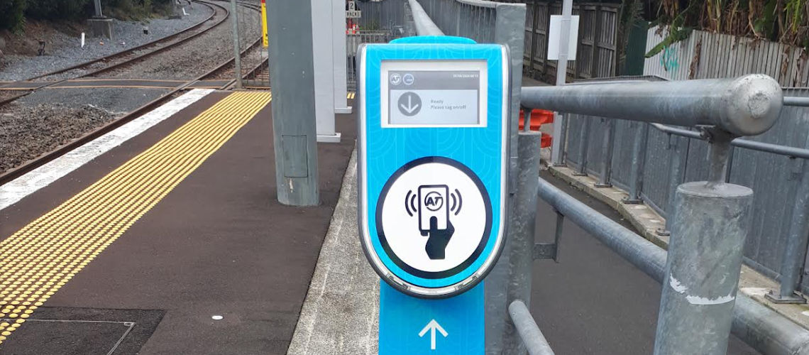
An example of one of the new card readers.
Te reo names gifted for Eastern Busway
Names in te reo Māori have been gifted for stations along the Eastern Busway by local mana whenua Ngāi Tai ki Tāmaki and Ngaati Whanaunga. The names embody the history of Tāmaki Makaurau – a fascinating story of forbidden love, fierce battles, and the physical fallout – and will apply to four stations and three structures.
Stations
When the 7km busway is completed it will span from Panmure to Botany and will have four new stations: Pakūranga in the town centre, Te Taha Wai near to Edgewater College and Shopping Centre, Koata by Riverhills Park, and Pōhatu in Burswood.
- Te Taha Wai represents the water’s edge, the riverbanks of Te Wai o Taiki (Tāmaki River)
- Koata speaks to the heart of Tī Rākau, the New Zealand native cabbage tree which is found in the Pakūranga area
- Pōhatu stone or rocks. This references the outcrop of rocks in the Tāmaki estuary which Ngāi Tai legend acknowledges as the perished tūrehu and patupaiarehe peoples.
Structures
- Rā Hihi (sun’s rays) will be the name of the flyover being built above Reeves Road in Pakūranga. It will improve traffic flow and reduce congestion, playing a crucial role in the Eastern Busway’s success in providing quick and reliable travel, and is planned to open in 2026
- Tī Rākau will be the name of the new bridge that will sit next to Tī Rākau Drive. Rākau (tree) is also a traditional Māori stick game.
- Taupaepae (to meet or escort your visitors) will be the name of the bridge joining Tī Rākau Drive and Burswood. It represents the manaakitanga of Auckland Transport safely guiding and transporting the community along the bridge. Paepae is the horizon.
An altogether great coincidence
And AT and Council are still running that stealth advertising campaign for you-know-who… thanks, guys!

An AT bus emblazoned with an ad for an “altogether Greater Auckland.” We’re flattered!
Making Great North Road greater for people
A welcome confirmation that the Great North Road project will get under way in October:
We are pleased to advise construction is expected to start in October on this much-anticipated, transformational project. The project covers a 1.65km route along Great North Road – from the intersection with Ponsonby Road to Crummer Road – and is expected to be completed by December 2025.
This is a priority project for AT because there is clear evidence that we can reduce harm, optimise the speed and efficiency of the public transport network and deliver improvements for businesses. At the same time, we are improving road user safety and experience with road resurfacing, maintenance and intersection upgrades.
This is indeed a “much-anticipated, transformational” project and it’s pretty rich to see those words in the announcement. After all, this one’s been on AT’s books since at least 2015, and was green-lit for construction in 2021. Then, after the AT Board slammed on the brakes in October 2022, it was an overwhelming community push that got it rolling again.
One last-minute change is the “pragmatic” removal of raised tables from the mid-block crossings. AT says it’s “determined that the signalised crossings on Great North Road (including the 2 new crossings) achieve the desired safety outcome without the need for speed tables.” However, the move seems in line with the haste at certain levels of AT to fall into line with current political reckons, regardless of the safety and accessibility implications.
Still, credit where credit’s due: it’s finally happening.
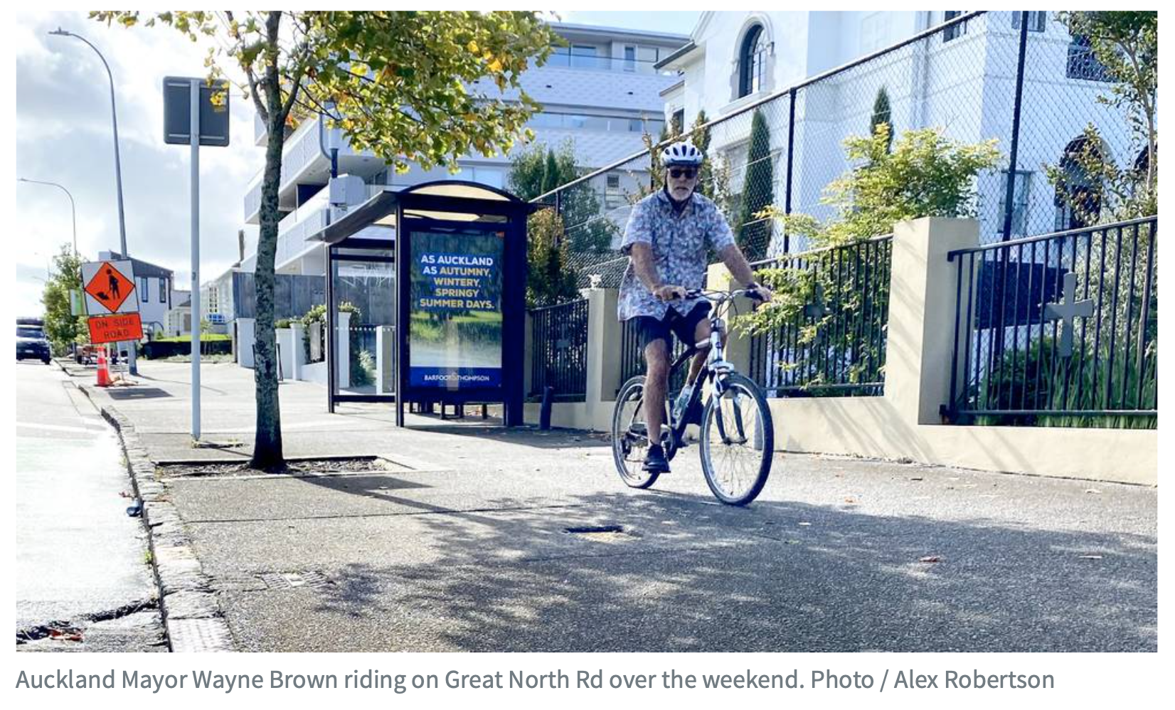
The Mayor will no longer need to ride on the footpath, once the Great North Road works are complete in 2025.
Duck, duck, pūkeko: a new crossing for Western Springs
Further west on Great North Road, AT is adding a signalised crossing at the main entrance to Western Springs Park. The work will take place through September-October.
Lots of people cross here between the parking area and the park, and the current safety situation is subpar. With four lanes of live traffic and two parking lanes/ timed bus lanes, the existing concrete pedestrian refuge can barely accommodate a family, let alone anyone with pushchairs or wheelchairs. So, this is an improvement.
And it’s better late than never: funded by the Local Board Transport Capital Fund, it was first consulted on in 2020 (!) by the Waitematā Local Board (!!) and is being delivered under the Albert-Eden Local Board (!!!).
Note that AT plans to trim the adjacent pōhutukawa trees so the traffic lights can be visible to drivers, and notes there will be “low impact on traffic flow, as crossing time is only activated when someone needs to cross by pushing the button.”

What you ordered vs. what arrived from KiwiRail
NZTransitBuzz also got hold of some renders from Kiwirail for the new Drury and Paerātā railway stations that are to be built between Papakura and Pukekohe. We’ve seen plans for the stations before but these renders highlight how much of a disappointment these stations are compared to what they could have been.
Drury
The council’s vision in 2019 was for a station connected to public space and a town centre and housing, instead what we’re getting is a station isolated from surrounding development by carparks and stormwater ponds with the closest housing hundreds of metres away. Our agencies and their consultants claim they want these new suburbs to have PT modeshare but then they keep designing to prevent it.


Paerātā
At least the park and ride is on the opposite side from where the housing development is happening but why for example weren’t the stations integrated with the road crossings to reduce costs and provide faster and easier access to the station for bus users.

Note how both stations also appear to have almost no shelter. How are these costing $500 million. Remember the impressive new Puhinui station was only around $70 million
Auckland stinks
But in a good big-city way? Shanti Mathias for The Spinoff takes a deep breath and explores the olfactory riches the city has to offer. This story is nothing to sniff at.
Enough humans have graced Auckland with their smelly presence for a little bit of each to rub off, and build up into a nose crinkling, nausea inducing, disgust forming, patinated presence. The city is like an authentic antique, holding its history perceivably.
Wellington cycleway design challenge
In 2023, Wellington gained recognition for its ambitious advances in cycling infrastructure: it was one of ten cities to receive a Bloomberg Initiative for Cycling Infrastructure (BICI) grant from the the Global Designing Cities Initiative (GDCI).
Rolling out a city bike network at pace poses creative and practical challenges. Sure, hit sticks and rubber bumpers get the job done fast and affordably – but they’re not especially attractive, don’t offer full protection, and come with maintenance issues.
So Wellington City Council is running a design challenge in search of innovative and attractive cycleway separation, with a local flavour:
We’re looking for designs for a new form of cycleway separation that is safe, flexible, durable, affordable, with an aesthetic that speaks to the Wellington context. WCC will take the winning design to work with local manufacturers to produce a prototype.
Full details here on how to get involved. The contest runs until 29 September 2024, and includes webinars to bring everyone up to speed, plus there are real prizes at stake! It’ll be fun to see the designs, especially if the resulting products can be adapted for other cities as well.

Public transport adds life
Sydney is absolutely killing it. This is just one example of development as a direct result of public investment in high quality public transport, both subterranean metro and surface light rail – along with beautiful placemaking with extended pedestrian areas, and traffic increasingly restricted from intruding into civic space. Look and learn!
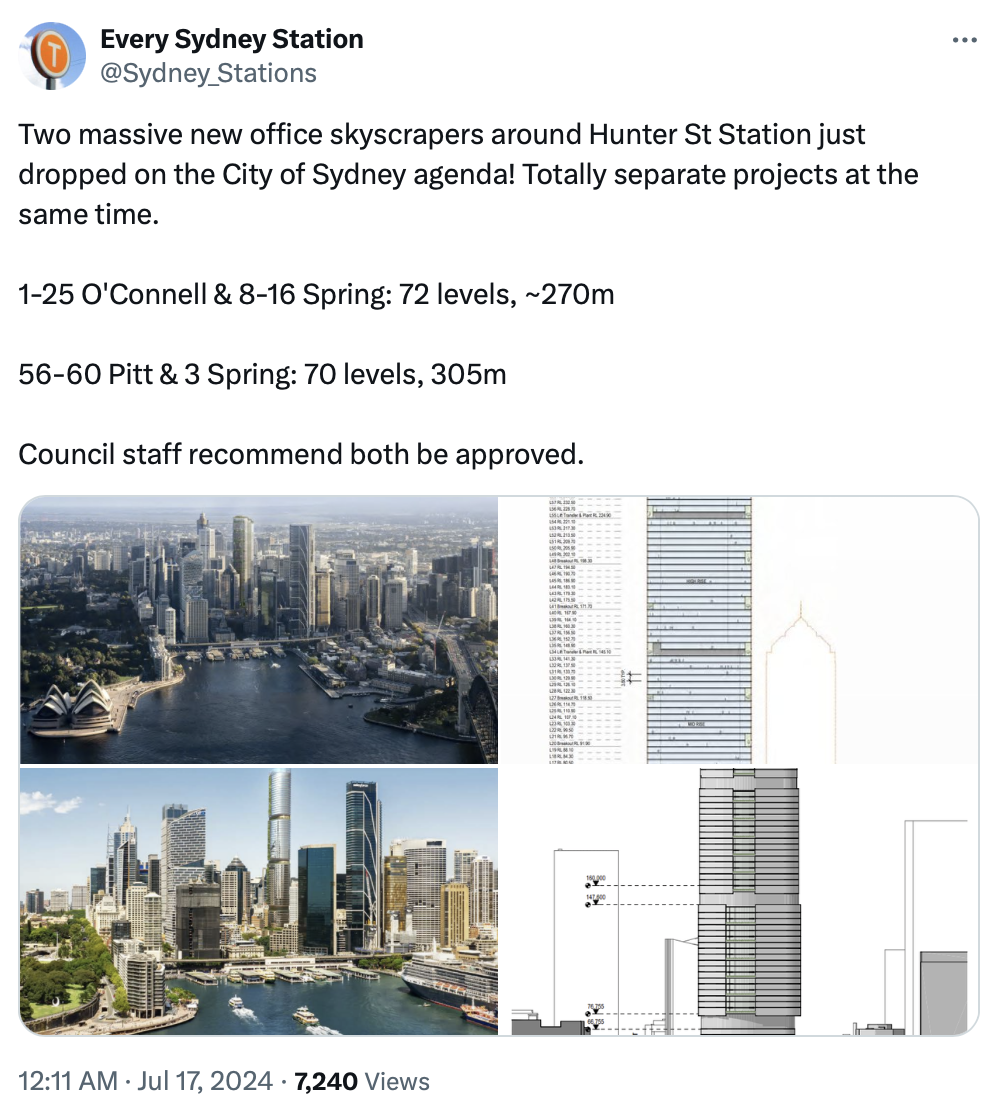
A tweet by @Sydney_Stations about two new office skyscrapers, 17 July 2024
Some long reads for your weekend
- Why the Fast-Track Bill needs to incorporate climate mitigation to get back on track (Newsroom)
- How a planned community in Vienna that puts the needs of women and children first (New York Times gift link)
- What happens when you build a fence in a small town (New York Times gift link)
That’s it from us for the week – enjoy your weekend and stay dry!

 Processing...
Important (critical) note is these new developments in Sydney are also happening because they recently removed their height limits. Maybe we should do the same given most of the city centre is restricted to 72.5m or less
Re Western Springs crossing:
“low impact on traffic flow, as crossing time is only activated when someone needs to cross by pushing the button.”
What they don’t say is that it will take a minimum of 5 minutes before activating 😉
One of the worst for this is Quay St at Tapora St
Drury is just a timebomb – the congestion on the southern motorway will terrible. Why are we so averse to developing right by stations? The whole of the Northern busway by stations is just marshland, golf course, driving range and of course car parking!
You forgot Sunnynook! Tiny platforms, walk up only and busy as!
As memory serves the Drury West (Ngakaroa, iirc now) was deliberately located further away from the existing development (“Auranga”), over the wishes of the people doing that development. I hope that I’m misremembering this because it seems… insane?
The Drury train station is, of course, located at almost maximum inconvenience for anyone who already lives in Drury whilst still being in Drury. It’s not some new community… it’s been around for well over a 150 years. Though, to be fair, it’s not like there’s a good location north of the bridge you can see in the render, but that’s where everything that’s not light industry is, north of the bridge. I guess the best site further north was to build a station right next to the rugby club.
The fact Drury is an existing place is the answer to your question. Developers by as much land as they can for as little as possible. They acquired large amounts of land not particularly close to the NIMT because there were big land owners who sold first. The people owning land closer to the tracks presumably have smaller holdings and/or didn’t sell fast enough.
Paerata is, I believe, mostly expanding off the back of land sales by Wesley College. What little older housing is in Paerata is, of course, close to the tracks.
If they ever want to open a new Opaheke train station, the land around the train tracks looks likely to be held by a small number of large landowners. But aside from freak situations like that (which might not even be true), you’re never going to be able to develop land close to the NIMT that’s also close to the existing urban area.
Incidentally, there is new development in Opaheke and it’s surprisingly far from Papakura train station: twenty minutes iirc, though I just checked on Google Maps and it says 28 minutes. Looking at Google Maps the NIMT is maybe too curved where I was envisioning the station and a bit further south is… already occupied. Further north just gets closer to Papakura and is, of course, also already occupied.
I think the Auranga developers actually wanted it closer but Kiwirail/AT didn’t support that because it would be too close to the Drury station.
Those two stations are just over bridges with platforms attached. They are the same design as Te Rapa. Rubbish but cheap as chips.
People should be asking serious questions to AT, KiwiRail and central government about where that money is going to.
Outstanding quality from GA as usual.
$50 fare cap! Finally! Can get back to riding more trains for the sake of it lol. Have used this while in Sydney before and it’s great.
I have to say I don’t agree with not naming the stations after the suburb they are closest to. Pakuranga makes perfect sense as it’s the name of the town centre. Stations like Pōhatu should just be called Burswood with the translation underneath why complicate things. Our train stations mostly follow the simple logic of being called after the suburb they are in why not apply this to the busway as well? I note Fruitvale rd could be called Kelston one of the few I’d probably change.
I tend to agree with you; while I like the use, storytelling and history behind the Te Reo names and would use them as much as possible, Burswood was one that at least should have retained the areas name.
My main bugbear is changing Aotea. Great Te Reo name, synonomous with the area and structures around it. Oh well.
I also agree KLK I really like Aotea as the station name and it had a nice ring to it and was short “meet me at Aotea” now it’s “meet me at Te Waihorotiu” it’s not like Aotea wasn’t a Te Reo name anyway one of the changes I really couldn’t understand.
Directly translated it means ‘the wet Affco freezing works’
The issue is that while it is a te reo Maori word, it’s was picked for the square back in the 70s without asking any Maori about it, and the word has no relevance or connection to the place. It’s actually one name for great barrier island, and the name of a canoe significant to Taranaki iwi, but nothing about the place in central Auckland.
WTF they are changing the name of the Aotea station? It’s not even open yet!
Aparently it’s been changed to Te Waihorotiu which is a complete mouthful to say(4 syllables vs the 1) Aotea was so much better and made infinitely more sense. I suspect some people got bored and wanted to change the station names for the sake of it. Britomart another great example Waitemata is so vague as it could literally be talking about any part of the harbour. Not opposed to Te Reo names at all I don’t understand why every single station name has to be renamed seemingly because someone got bored. Changing Britomart to Waitemata is like changing Ranui station to “Midday” because you want to change the name to English it just doesn’t make any sense Ranui is the name of the suburb therefore the station should be called Ranui
I have no idea why you think Britomart is the more appropriate name for the railway station. It was a Royal Navy ship and a long demolished point on the harbour.
Britomart, at the time it was given that name, was precisely as nonsensical as these names. And if someone went to the NZGB they’d probably be thrown out for the same reason the proposal to name the Drury Central station Te Maketuu Railway Station was, i.e. stations are meant to be geographically specific as it aids their functional purpose. However, bus stations might be regarded by the Board as being subject to different decision criteria.
Britomart does illustrate that you can name stations any which what and it doesn’t matter. However, the NZGB absolutely shouldn’t have referred Waitemata vs Britomart to the then minister (some Labour guy, can’t remember who) to choose which he preferred by Ministerial fiat, because Britomart has now become associated with the surrounding area and there are many train stations in the Waitemata local board area. The merit Britomart lacked as a station name in 2003, it had gained by 2023.
Personally, I don’t think naming stations after water geographies that aren’t small lakes is sensible. Imagine if you had a Nile, Amazon, Pacific, Atlantic etc. train station. Highly specific! This affects three of the stations from that round of naming, i.e. Waitemata, Ngakaroa and Te Waihorotiu. I could kind of understand the name if you could see the water from the station but that doesn’t even apply in two, possibly all, of these cases: Britomart’s underground, the te Waihorotiu stream is underground and I think the Ngakaroa stream is too far away from the Drury West site to be seen but I’m not sure.
You’ll be fine.
Waihorotiu is no more of a mouthful than Karangahape, Wellesley, Kitchener or various other places and streets around town that people use every day.
I think the point with Te Waihorotiu is that it refers to the valley that the Waihorotiu stream created as much as the rivulet itself, i.e. the Queen Street valley that contains the core of the CBD and the main area served by the station.
Because there will undoubtedly be some kind of outrage from the anti-reo crowd, I propose we introduce some proper English place names to see how well they can pronounce them, starting with this one: Woolfardisworthy
100% what the culture war crew want from everyone, all the comments in here discussing Te Reo names and not the absolute carnage that we are getting out in Drury for $500m. Working as it’s designed…
“it will improve traffic flow and reduce congestion, playing a crucial role in the Eastern Busway’s success in providing quick and reliable travel”
Will it improve traffic flow and reduce congestion though ?
Seems unlikely!
No chance. It’ll have the opposite effect.
I’d be amazed if there’s a flyover located anywhere in the world that did what it was primarily built to do (reduce traffic).
Personally, I have the good fortune of being a multilinguist, so complaining about Reo names that have real meaning seems a bit monolingual.
For me it is excellent that Taamaki Makaurau remains a Bastion of Te Reo, when our provinces and Wellington appear to take issue with knowing more than one language.
We are all entitled to invent our own names for the stations we regularly use, so one does not need to be limited by the official name, Reo or Colonialist.
Call your local station what it looks like, through the eyes of a four year old, and pretend things aren’t so bad, for a moment!
bah humbug
That’s great Maituu, I think the point most of us here were making is not to take issue with Te Reo names like you’ve said you’re entitled to call Aotea station what you want. I think the majority would’ve preferred Aotea and Britomart. It’s about making our train network simpler to navigate not a competition on who can come up with the most obscure name. We have a very real issue where a tourist could be wanting to go to Aotea square and rather than taking a short walk from Aotea station they will have to figure out that the station is some obscure name. I think you’ve also missed the point that people would complain about any name that doesn’t make sense even if it’s in English. If they tried to rename Otahuhu station to Mount Richmond station there would be an uproar and rightfully so, people just want a simpler train network that’s easy to understand. No one is here to start a language war it’s about simplicity.
Wait till you leave New Zealand and try navigating your way round another countries metro system. Tokyo was in symbols but I still managed to get to where I need to get to..go easy on the concern trolling, have you ever spoken to a tourist and asked them or just made this scenario up in your head.
Damn it, got sucked in by the culture war nonsense.
Great week guys keep it up!
I much prefer the new card readers on buses – I haven’t had any issue with missed scans, which I had quite a lot with the older card readers. I spent 20 minutes on the phone with AT last week trying to sort out a number of issues (and the refunds haven’t come through yet).
The PIDs issue is a long running cruel joke. To raise vandalism in one location as an excuse is nothing but salt in the wounds. Currently there are three different systems around the network and none of them work properly. Almost every platform has missing, damaged, non-functional, turned-off or misleading displays. One a Greenlane was removed over five years ago and never replaced. The other side gets stuck on a 9pm setting every night. Papakura’s off-platform displays haven’t worked at all for months and you can’t see the platform ones without going down to the gate line and then potentially having to run back up the stairs if you guessed wrongly. These problems are repeated across the network daily – even worse AT simply turns off the displays during disruptions “to avoid confusion”! It’s a sick joke and we all need to start making something of it.
Entitled to entitlement seems to be the mantra of this government.
“Transport Minister Simeon Brown says the upgrades will ensure the network remains resilient, reliable, and efficient for road users.”
“Visiting the Coromandel today, I understand the impact the current Pepe Stream Bridge is having on the local community and motorists that are visiting Tairua. At 81 years old, the single lane bridge is a bottleneck, with severe congestion experienced during holiday periods.
It’s sad that we have economic, including roading decisions made it seems with a focus on people better enjoying their holidays. It of course follows on the bizarre decision to prop up Turoa when it clearly has been uneconomic.
Maybe these bridges will be funded by the tremendous productivity savings from the PISS programme?
The road becomes unusable during holiday periods, but not just for people on holidays. There are people who live and work in the Coromandel and use SH25 to get around. An ancient one-way bridge inside a town that bottle-necks the road in both directions should be a natural candidate for an upgrade at some point.
As for Turoa/The Skifields: It’s not simply a case of whether something is economic or not; given some of the decision-making and investments on the mountain. There’s a huge cost to the wider region of not having ‘something’ there, but it sure as hell needs to be run a lot differently.
BW
I worked at Turoa for three years. I remail unconvinced that it does much for the whole region. Yes its a boost for a part of the retail sector; great for hospo; and purpose built accommodation. Three months employment for some locals, yeah that’s helpful but not life changing. However the problem is that there has been and will be even less snow. That’s essentially why it failed, although covid didn’t help. The whole set up is environmentally unhelpful with most of its customers driving vast distances, many in SUV’s; not that this government has any sustainability focus.
And the Coromandel? It appears to be an area that is very prone to adverse weather events. How long can the government afford to build back, and better? For parts of the Marlborough Sounds roads the money has seemed to run out. Maybe the solution is completely self funding roads? If a community wants a new road/new bridge, is there enough money in the pot. It doesn’t seem equitable that we have kids in poverty all year round, underfunded hospitals over the same period; and yet government can find money from general taxation for a bridge for half of December and all of January.
Great to have the frequent 94. The added capacity between Akoranga and Takapuna (which will be reinforced again when we get the frequent 81) further strengthens the case for one of the quickest wins on the whole network in my opinion: replacing the 843 with an extended 82 to Constellation via East Coast Rd. Would be cost-neutral (or thereabouts) and it’s important to start plugging some of the gaps in the North’s frequent network, which still feels very incomplete. Some peak trips could continue to terminate at Milford.
94 also seems like an obvious candidate to loop back around to Takapuna via Glenfield to convert the 941 to frequent operation, per the original AT frequent network plans. Clockwise and anticlockwise loops from Takapuna would work well.
I thought the new card readers were actually easier to read, higher contrast, brighter or something. Maybe it’s because they are just less scratched.