FIVE MONTHS
That’s how long, starting this week, the busiest bus interchange in the country will be closed. It has only been opened about 18 months since the last upgrade.
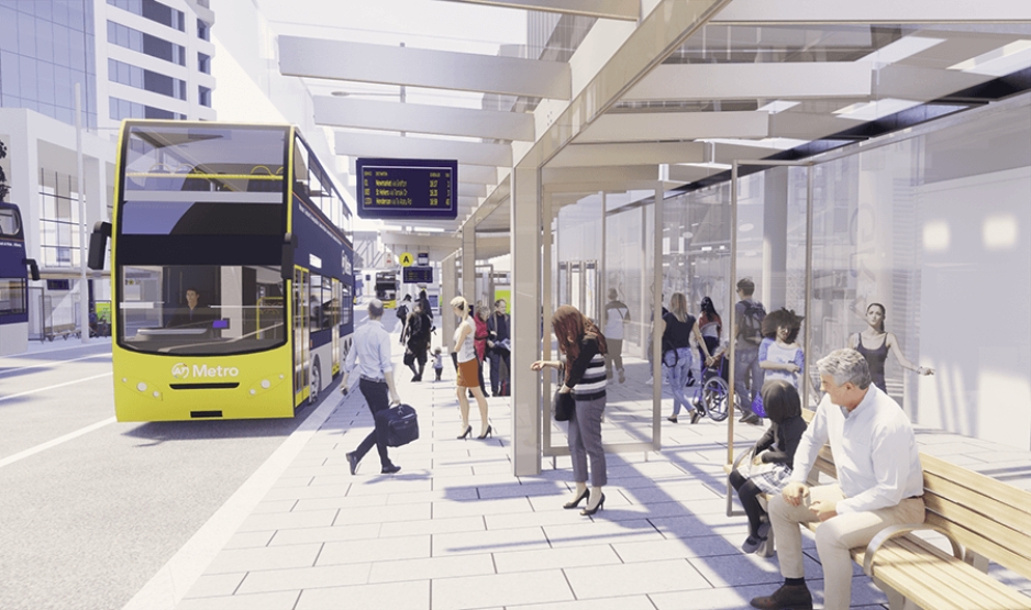
This time around the closure is to enable Auckland Transport to install the shelters and seating that should have been installed as part of the original upgrade – but were removed from the programme following budget cuts in the wake of COVID.
From Sunday 5 June, bus services that usually use Lower Albert Street Interchange (NX1 and Northwestern services) will be using other city centre stops. Our AT Mobile and Journey Planner have been updated, so you can plan your trip. Find out more: https://t.co/EzNXWbmnt9 pic.twitter.com/Bg31CsUx0L
— Auckland Transport (@AklTransport) May 30, 2022
I’m glad the shelter and seating are finally going in, but cutting the shelters from the budget revealed the low priority that Auckland Transport gives to public transport users when making decision. The Council’s decision to cut the budget for the project as part of $119 million package of cuts would have almost certainly been on the basis of AT recommendation, just like they tried to do with the cycling budget this week.
As for why it’s taking so long and some of the other common reactions to the news, Stuff’s Todd Niall has this.
“Five months?!” was a common response to news of the length of the job. After all, the street had already been prepared for the structures’ eventual, belated installation.
A big part of the explanation from Auckland Transport seems to be that it is trying to do the work in a way that causes the least disruption to Covid-hit businesses on the street.
Another aim was to maintain two traffic lanes – not just for buses to pass through but also for general traffic, some of which accesses an underground car park below the Commercial Bay precinct.
The erection of the steel structures will be followed by measuring-up for the glass sheets that provide the shelter, meaning perhaps a month-long pause in construction.
Couldn’t one side of the street be done, then the other, to halve disruption to bus users heading either north or west ? No. The space needed for construction made that impossible, Auckland Transport said.
Couldn’t it be done in summer, when bus use is lower and shelter from the elements less of an issue? No, because summer is a more important time for businesses in the vicinity.
On the design itself and the temporary disruption, a few thoughts:
Shelters
The shelters on the western side of the street have already been put in place so this closure is just to build those on the eastern side.
It’s hard to tell from the images given how the reality is often quite different, but I really hope they’re designed to enable full rain protection for passengers. One thing that can be incredibly frustrating about so many of Auckland Transport’s designs is the shelter stops short of the kerb meaning that when it’s raining there can be a curtain of rain to get through to get on or off your bus or train.
Interchange Amenities
The seating will be a welcome addition but there has been no mention of other amenities that should be mandatory at such a busy interchange. For example, are any HOP machines being installed so people can top up their cards or do people wanting to do that have to go over to Britomart? What about things like drinking fountains that make it easy to drink directly or fill a bottle?
There is no mention of things like these on AT’s page for the project.
It would also be good to see improved wayfinding for those bus to train or ferry transfers
Supporting buses during the disruption
While most of the temporary bus stops are on routes with bus priority, the NX1 isn’t and that’s a concern given it’s the busiest service in the city. That’s because while the city centre might be quieter now than it was before the pandemic it doesn’t mean buses won’t get held up in traffic. During the original closure of the bus interchange it wasn’t uncommon for buses to get held up in traffic and/or having cars and delivery trucks sitting in the bus stops blocking them. AT should be adding temporary bus lanes to the sections of Customs St the NX1 will be running on to help keep it reliable.

Why not start enabling AT’s City Centre Bus Plan
Incidentally, during the previous works I actually found the temporary bus stops on Customs St more convenient than the downtown interchange even though the quality wasn’t as good – as the transfer was shorter, especially going from bus to train.
Last year we learnt that AT’s proposed plan for buses in the city was for the NX1 to stay on Customs St and travel though to a new terminus on the eastern side of the city rather than terminating on Lower Albert St. So why not make moves to start implementing it? I suspect a lot of it could be implemented fairly easily without the need for a big off-street bus interchange facility like AT want.

What’s happening to the sale of the Downtown Carpark?
This thought isn’t directly related to these shelters but it did make me wonder what’s happening with the sale of the Downtown Carpark.
A part of their push for big bus interchange facilities in the city, one of the first of these is likely to be an extension of the Downtown Bus Interchange and AT were eyeing up retaining floor space as part of the sale and redevelopment of the downtown carpark. Following criticism of this they’re also considering options for the facility to be on lower Hobson St, perhaps harnessing space from the removal of the Hobson St flyover.
The site went up for sale last year and tenders closed at the end of November so hopefully we’re getting close to hearing the outcome of that and seeing what the plans for the area are.

 Processing...
Five months to build a few small shelters????
This is the kind of bullshit that just ruins the public’s trust in Auckland Transport. Sounds like the kind of job that should be done in 5 days, or a few weeks at the absolute most.
Fire everyone involved and start again.
Yes there will be one month to set up the site, 3 months where they will have one man and a wheel barrow onsite and then one month to build.
The Takapuna bus shelters went in quicker, without a road closure (or at least it was only closed for one night to put in pipes and services across Lake Road), without diverting buses, and that job included paving the footpaths on both sides and part of Como Street.
“one man and a wheel barrow” – we should be so lucky, normally they have a load of very expensive machinery doing bugger all.
Prefab shelters. Drop them in over a week. Another week to tidy up and get connections sorted.
Takapuna took a bit longer than that. King Builders from Browns Bay had the steelwork built in Ellis Road and hotdipped and painted. Once all was ready they dug and poured foundations and lifted the frames on with a forklift. The following day the roofers came and after that the glaziers. Then Kings did the timber work and connected them to the stormwater. All up it took a couple of weeks on the site due to keeping 3 of the four bus areas open at a time. The paving and underground pipes all took longer. All of that and they never damaged the COMPAC cable which in 1991 was a major deal for offshore communications. The single biggest job on site was cutting through the pile of old steam tram tracks someone had buried there.
“ One thing that can be incredibly frustrating about so many of Auckland Transport’s designs is the shelter stops short of the kerb meaning that when it’s raining there can be a curtain of rain to get through to get on or off your bus or train.”
Recently took a ferry up to Hobsonville Point and was puzzled to see that to get to the flash new berths on Queens Wharf you have to go out and around the ferry building with no shelter.
I wouldn’t see it as very important for bus stops. You stand in the shelter, bus stops and opens the door, you hop through a brief shower for less than a second and tag on. That’s less than going from your house to the car in the driveway and given that you are likely walking the last meters to your destination you woud need some sort of rain protection anyway. So as long as the roof is not designed in a way that it is explicitly pouring on people, I don’t see a problem.
5 friggin months is a problem though.
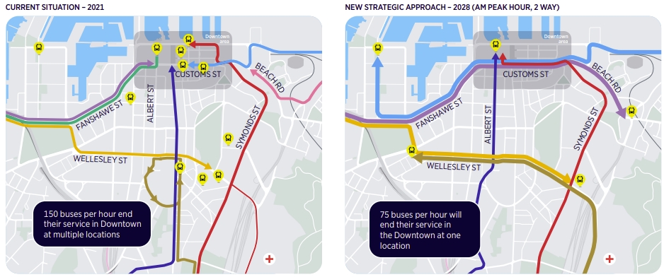
The second map with busses terminating all in one place seems great though. Transit between lines for me usually involves walking a couple hundred meters to some street nearby (Fanshawe -> Daldy street or Lower Albert -> Commerce Street) which can get you actually pretty wet in the rain. Having a central Britomart or Waitemata bus hub would be awesome! That would also justify closing a bus stop for 5 months 😉
5 months!!!!!!!
Also, why there are so many road improvements around Auckland stopped for no reason and start again few months later. Is this because the resource is stretched all over the place? This need to stop and we want a start to finish plan within the reasonable timeframe.
5 months? I wonder if this includes the apparently mandatory completion delays?
Just on the northern Bus way. Can we get some dynamic lights to give busss priority in the 5 set of lights between the motorway and the transport “hub”. It is pretty much faster for me to walk that leg.
Absolutely, what a joke. Getting from downtown to the on ramp can take so long. Especially with cars pulling in and out of the “bus lane”
I caught the NX1 yesterday. It’s ok going in, you just get off outside H&M.
Going home you’ve rightly identified as a mess. There’s no bus priority and because it’s ‘quiet’ in town (it’s not), there are a lot of people driving.
I ended up going to Fanshawe St to double my chances of getting a bus (NX2) but I can’t say I’m looking forward to the next 5 months of this.
Absolute joke, how did Commercial bay get allowed an underground car park so what should be a bus only street fills up with cars.
Same all over the city so not surprised – the new pinch point is now on Fanshawe heading to the bridge. The new Fidelity building with cars turning in and out and then the slip lane round Vic Park. And the buses actually let these cars go.
Bus priority is non-existent on what is the busiest stretch of busway in NZ.
Wynyard Quarter being another planning disaster. So many carparks. The logical consequence of this – unnecessary traffic domination – is ruining the walking amenity, and it creates phasing delays for all users at the Fanshawe St intersections.
Designing to accommodate all these cars means we now have a crap built environment, too, where instead of a footpath, you get wide, wide vehicle crossings:
https://www.google.com/maps/@-36.8434208,174.7573851,3a,75y,158.46h,76.26t/data=!3m6!1e1!3m4!1s8xwF6bDJmmGQ5sbG_iScBQ!2e0!7i16384!8i8192
Vehicles use it to do turns right over the footpath, at speed. I know local residents who avoid that stretch because of the danger. Just poor design, of the “shared space” misconceptions.
And the footpath has been designed at the Sofitel to look like it’s legitimate parking, which it’s not:
https://www.google.com/maps/@-36.8450415,174.7572862,3a,43.5y,70.4h,84.96t/data=!3m6!1e1!3m4!1ssTHpfsRnicvKsSjgfnYf2g!2e0!7i16384!8i8192
So depressing.
Looks like someone forgot kerbs exist.
Add a few strategically placed bell bollards.
Shared spaces suck. Who wants to share a space with a massive vehicle?
No idea why these are all over the city now. Need more London style wrought iron bollards that will actually do damage to the cars if they try park there.
https://www.google.com/maps/@51.5163349,-0.0928592,3a,75y,226.09h,82.23t/data=!3m6!1e1!3m4!1sp2Fqxk–Fsihv3SHzwBEEQ!2e0!7i16384!8i8192
+100
It is almost as if it is private property.
As if respect for private property rights never stopped the council from blocking developments.
Parking maximums, job done.
They have parking maximums already. That job was done years ago. We don’t live in a society where a Council can arbitrarily decide someone can’t have something. We have a planning system and a justice system and people have rights.
Miffy opposes access control, never thought that would be the case.
Wayfinding suggestion; a painted / decorated path that clearly indicates the walking link between the transport connections; the loop between Britomart Train station, the Ferry building and this bus-station.
In the far future, also a path to the light rail connections
Someone arriving at the train-station and wanting to head north on the bus or take the ferry has to rely on maps or those small blue signs stuck up in random places.
Nothing about this situation is making me want to commute by bus (I catch the #18) to regularly work in my CBD office (which is just across the street) post COVID. The harder it is to get to and from CBD easily = the longer it will take for its economic recovery. Yet another disaster brought to you by AT, and funded by us, the ratepayers.
Thanks Heidi – your google map links revealed this lovely photo. I love the Natural Habitats Ute in a temporary carpark. Auckland does Ugly!
https://www.google.com/maps/@-36.8431302,174.7575001,3a,44.6y,296.72h,85.72t/data=!3m6!1e1!3m4!1sT9lScwHlToh313AYoJH7UA!2e0!7i16384!8i8192
if you turn around you can see a nice old sleeper used in the carpark which has probably been hit many times it has split and no doubt will be gone soon.
This area is actually weird to walk around, crossing the road is hard because the trees block all line of sight and because everything is all one level there’s no surface changes to warn drivers or pedestrians. Why we keep doing this is beyond me.
And why anyone would think it’s OK to have pedestrians standing at street level at a corner like this, not even protected by a kerb. Making people sitting ducks to all the drivers who like to cut every corner they can. They’re going for the pedestrian environment **look** without bothering to provide the pedestrian environment. Just crap all round. https://www.google.com/maps/@-36.8436047,174.7573021,3a,60y,266.32h,61.28t/data=!3m6!1e1!3m4!1simet9YLFuCvH92fzT5l_Hg!2e0!7i16384!8i8192
That’s so frustrating. It’s so close to actually being good. Literally 3 bollards and that would be be one of the best intersections in Auckland.
Those people are called urban designers.
Sadly the story should be “bus stops moved to install shelters that are not really needed”. All that place needs is a few benches with backs, nice and close to the shops. The overhead shelter is already there. If they really wanted something a bit fancier, then maybe a few “walls” to stop the wind. These “walls” could be bus timetable displays.
I dream about Christchurch’s Bus Interchange. If only we could have that…
I have had the experience of taking buses in a city with a Big Bus Interchange overseas, the problem with it is that you tend to get a star shaped network around this interchange, and for most bus trips this interchange is in the wrong place.
In Auckland, going via Britomart is a detour for almost all trips that involve a connection between buses. And a quite slow one.
And it doesn’t scale. That interchange overseas was already super busy, and that was in a city of less than 150,000.
I don’t. Requiring every bus that has a simple route through Wellesley St to instead go to Britomart to then wiggle into a terminal then have to back out doesn’t improve anything. It adds cost in a place where land is at a premium though.
We have Manukau I guess?
Please no, the finally might get tge car priority reduced, let’s not waste it by putting 500 buses an hour into a single point. If we make all routes cross tge city centre then we can make them all interchange but split it across a few different locations
Maybe take city centre design off AC and give it to AT? Kerbless streets that are not safe shared spaces, trees of the wrong shape to see past.
Commercial Bay is the driver for a lot of the relationship collaboration issues. Keeping those businesses operating (or people might go to Queen Street instead?). Commercial Bay is a block with four frontages. Which one can a carpark/service yard access go into. They didn’t pick Custom Street. And there is a railway underneath. Yes, it would have been nice if there was enough money to finish the job originally – but there wasn’t.
Looking at that map there appears to be a golden opportunity to have the NX1 continue through to the vicinity of the Strand and be the key rapid transit connection for regional trains.
That’s actually a really good idea.
This is a ridiculous amount of time but seems necessary for a number of reasons. It seems to boil down to traffic flow yet again though. I didn’t know there was a carpark under the Commercial Bay property.
I can repeat again.
This CCO is broken.
The fundamental issue is this CCO AT has no accountability.
If AT is a political party it get voted out.
If AT is a private company it got bankrupted.
AT can do a poor job, the CEO can be sacked, but the underperforming decision maker are still having a job and paid awesomely.
Just disbanded the AT and spend the budget to local council. At least local councillors are elected and they can be voted out when they started to become corrupt.
Spend the remaining budget on subsidising bus companies and rail companies. They know how to run things efficiently and attract customers.
That’s all fine and dandy until an anti-cycling and anti-public transport Council or government gets voted in. Which has happened often enough.
AT shelters us all from changes in the political order, because they have to balance between the two levels.
AT go where the money is and the money is in the RLTP allocation.
AC got no money, and they would shred AT’s budgets far worse than they are.
Last year was the peak of any major transport projects in Auckland for a very, very long time.
A bunch of shelters aren’t really a bus terminal are they? Whats needed is a proper terminal like Manukau or Vauxhall in London. The powers that be screwed up when Britomart was designed and didn’t build what was necessary, and we’re left with the present mess which even when shalters are installed will still be a mess, just not a wet.
Even better would be to remove the vast majority of the buses from the city entirely by replacing trunk routes (North Shore, Northwest, Sandringham) with proper steel wheel mass transit
https://www.greaterauckland.org.nz/2011/10/30/a-cbd-bus-tunnel/
“For example, are any HOP machines being installed so people can top up their cards or do people wanting to do that have to go over to Britomart? ”
Answer no HOP top up machines. AT’s “Customer Experience Team” expects you to top up on line, or walk across town to do a physical HOP top up. At. one time the AT HOP team put poster up on Wellesley St to promote that the nearest HOP top up location was on Qualy Street!
“It would also be good to see improved wayfinding for those bus to train or ferry transfers”
The AT Wayfinding team was made redundant 3 years ago, to be replaced instead by some Te Reo wording at the Puhinui Train Station
That’s an idea. Some topup machines around the Wellesley/Queen St corner for bus users.
“The erection of the steel structures will be followed by measuring-up for the glass sheets that provide the shelter, ”
This delay is because no one on the design team knows how to use a CAD programme. Instead, a man with some orange safety cones, a clip board and a $3.00 measuring tape, will visit the site to “measure up” once the structures have been installed, and have been roped off.
There will then be a three month delay whilst the glass panels are cut to size.
Meantime the bus users will be getting drowned in Auckland’s winter weather.
Bus shelters never were any good there 20 years ago, cold/wet and miserable waiting. Back in OLD 1960, Britomart had a bus interchange ( look it up on the net ), dry, safe, shops and services close by. AT could learn something from Aucklands transport history.