The release of the latest Auckland Transport Alignment Project two weeks ago included this comment about light rail.
“This ATAP will see our rapid transit network grow considerably. I’m looking forward to updating Aucklanders on the next steps for light rail next month,” Michael Wood said.
A similar comment was made by Deputy Prime Minister Grant Robertson at an event just over a week ago.
We’ll need to wait to see just what the announcement is but it almost certainly won’t be that the project is starting. Most likely it will be announcing the ‘public sector delivery model’ which was the next step announced last year following the mess created by the superfund process. Essentially this will be the Who, and it’s likely they’ll be tasked with (once again) working out the What, How and When.
Will the Ministry of Transport be given it to mess it up with a dodgy process a second time, will it be given to Waka Kotahi again, or perhaps even handed back to Auckland Transport – my guess is we’ll end up with some hybrid and all will be required to work together on it, along with the likes of the Council and Kāinga Ora.
As for what they’ll be working on, the first step will need to actually work out what the project is. The debate and uncertainty with light rail in recent years has resulted in more questions than answers and as such there are a series of decisions and/or trade-offs that need to be made. For example, the level of grade separation the route has, the actual route it takes, how much priority is given to speed vs coverage (number of stations/stop spacing), the level of level of future proofing, how it integrates with our existing system, any related public realm upgrades, the extent of integration with Kāinga Ora and other housing developments, and of course how long it will take to build and the cost.
Most of these trade-offs are extremely interlinked and with one side of the trade-off represented by the idea of either Light Rail or Light Metro. So with this post I thought I’d have a look at some of those trade-offs through the lens of those two solutions. I’ve covered many of these in the past, such as this post on making sensible mode decisions and looking at if it should be underground but it doesn’t hurt to revisit some of these.
There’s always plenty of debate about modes and technologies but these two are perhaps best described as
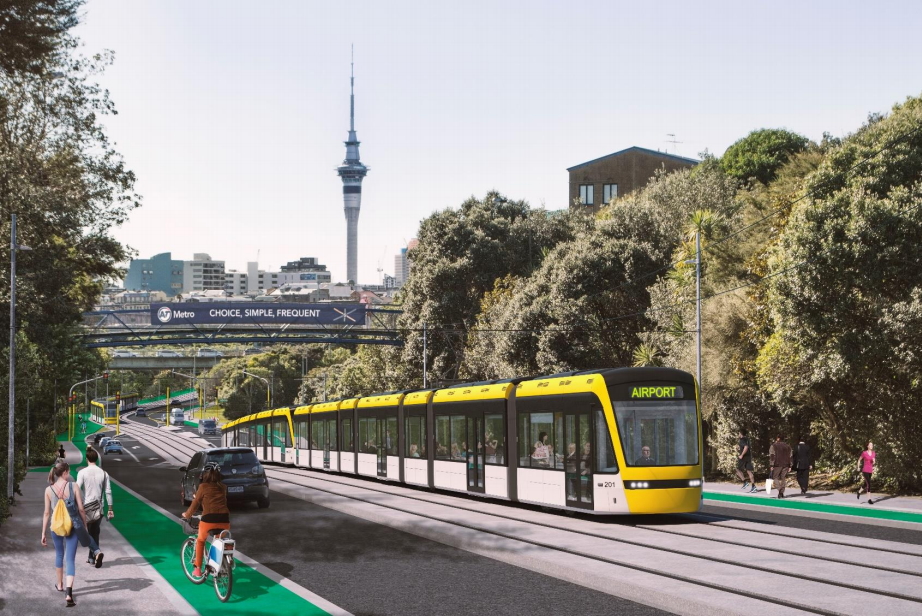
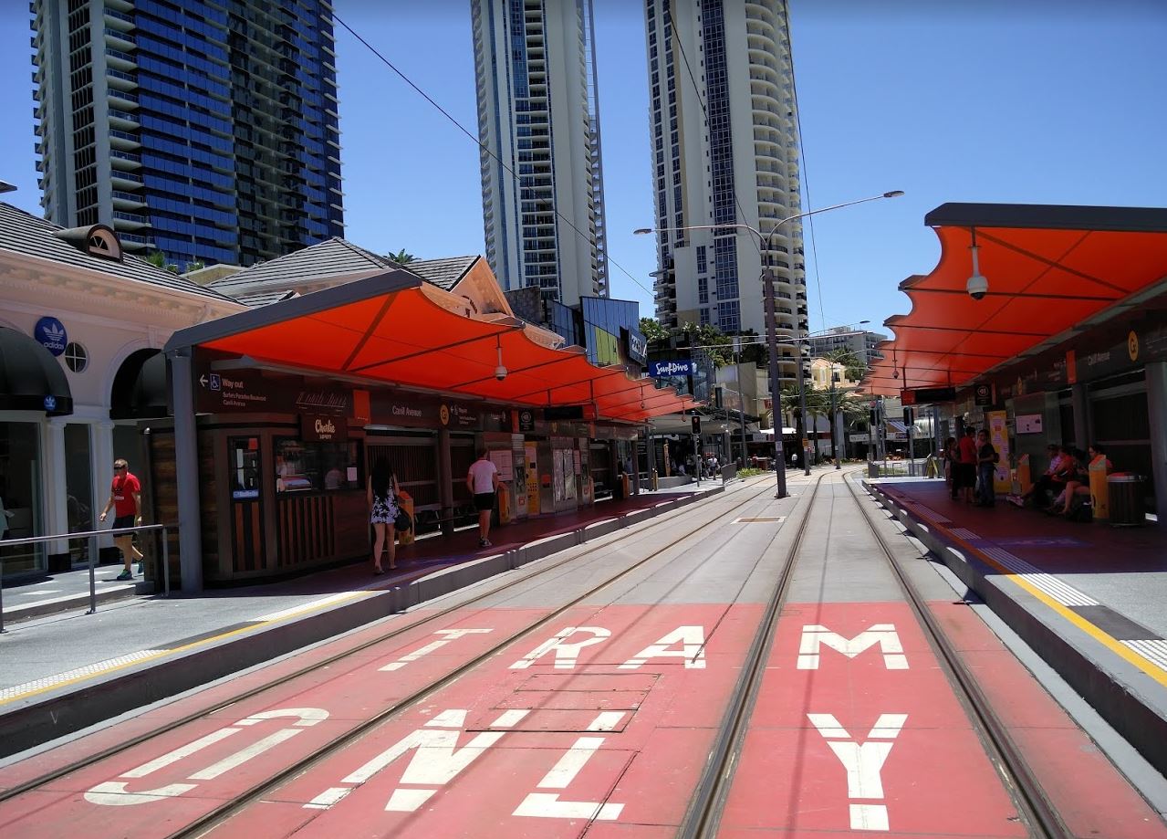
- Light rail – like what was originally proposed for the City Centre to Mangere corridor, a mix of on-street in dedicated lanes and off-road sections, similar to what’s been built in Sydney, Canberra, the Gold Coast and Seattle in recent years.
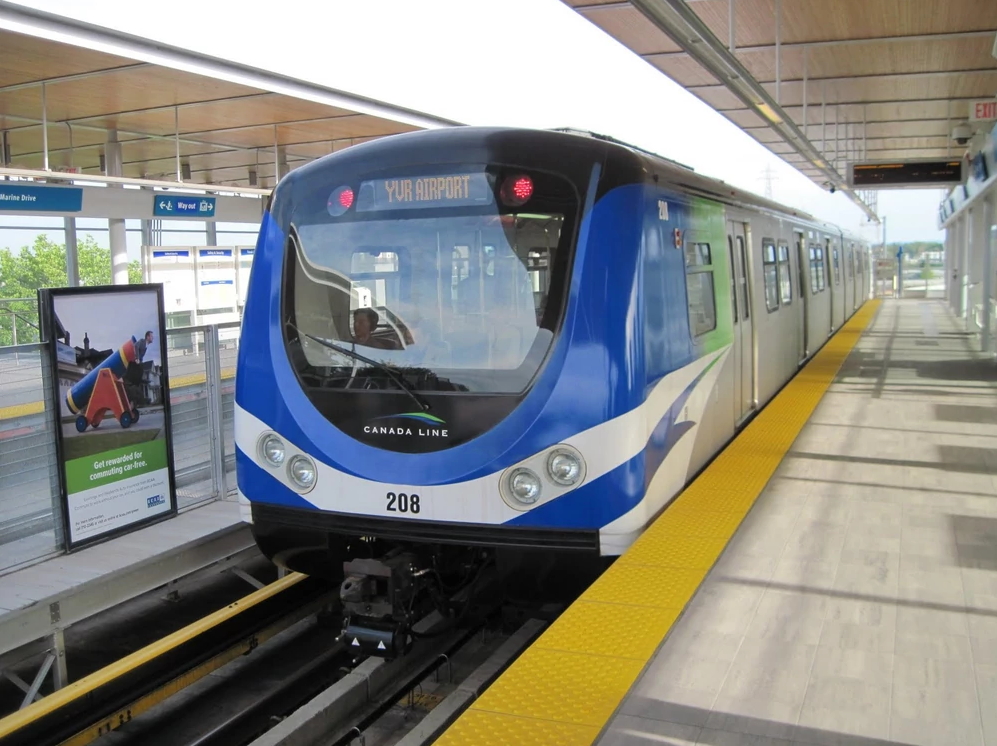
- Light-metro, essentially a fully grade separated version of light rail, but can also be with more metro styling/trains and potentially driverless. Examples of this include Vancouver’s SkyTrain and the Copenhagen Metro. Wikipedia sometimes calls these “Medium capacity rail systems“.
If we think about the City Centre to Mangere corridor, what’s notable is that for the most part, about 65% of the route, the part from Dominion Rd to the Airport, is same regardless of which mode is chosen, being off-road and grade separated. That leaves the main difference between these two solutions the section along Dominion Rd. So that’s where I’ll focus this comparison.
Route/Separation/Reliability
Light Rail
The light rail solution for Dominion Rd would be to have tracks in dedicated lanes that are separated from general traffic. This could be by way of kerbs or larger medians. Traffic would not be able to drive along the tracks at all, unlike bus lanes which have many exceptions, and this priority would extend through intersections to improve reliability. At intersections signal pre-emption would mean vehicles will not often have to stop, giving light rail vehicles a continuous run.
Light Metro
With the need to be entirely grade separated, light metro would need to be either elevated, underground or at least totally fenced off on both sides. Building an elevated line or a ‘Berlin Wall’ at ground level would seem near impossible to get public support over, and so it would mean the line would almost certainly need to be underground the entire route. At the city end of the line, the route would likely need to head under Symonds St and hook around under Wellesley in order to set it up for expansion to the North Shore. Being fully grade separated it would make the line highly reliable but at significantly more cost than a surface solution. We know from overseas that fully tunnel metro lines cost around ten times as much per kilometre than tracks at ground level.

Building an elevated line down Dominion Rd seems unlikely to get public support meaning an underground line would be needed for a metro solution
Stations
Light Rail
A big benefit to a light rail solution is stations are much easier, at their most basic they just need kerbs and shelters. This helps keep them highly accessible and affordable as there are no need for lifts and elevators etc. like with underground or overhead stations. A light rail station can be built more or less in the ideal spot at street level, while an elevated or underground station is often located wherever it’s feasible to build. For a route like Dominion Rd this means extra stations can easily expand coverage without having a significant impact on budget or travel times. One potential benefit of surface solutions is it also makes it more likely we’ll see other streetscape upgrades.
Light Metro
My understanding is the biggest and most complex and most costly aspects of the City Rail Link are not the tunnels but the stations and the same would apply to a light metro solution. This means for any metro solution we would want to limit the number of stations. Fewer stations does help provide a faster service but that comes at the expense of coverage meaning we also need more intensification around the remaining stations to get the same outcome.
To highlight the difference, this is an image I made for a previous post looking at 400-800m walking catchment. The image on the left is a metro type solution while the image on the right is a what we might see with light rail. As you can see, a metro type solution would leave some big gaps, particularly between Balmoral and Mt Roskill.

What this means is that if we were to build a grade separated option with fewer stations, we’d likely still need to run buses of some form on Dominion Rd to provide accessibility.
Speed
The level of grade separation and the number of stations all contribute to just how fast services would be but in reality the difference probably isn’t as much as people would think.
Light Rail
A light rail route from about the Civic through to the Mt Roskill shops is about 6.3km in length. Based on examples overseas, we should expect services to be able to reliably do this trip in about 18 minutes, even with Queen St having a 30km/h speed limit. At peak times that’s about 5 minutes faster than even the express buses today and about 15 minutes faster than regular buses.
Light Metro
The light metro route works out slightly longer at 6.9km due to needing to get under Wellesley St. However, the fewer stations and no street speed limits this does make for a faster service. Based on overseas examples and some of my own calculations, this suggests the trips is likely achievable in about 12 minutes, so about 6 minutes faster than the light rail option but you probably need to add at least 30 seconds on each end to get between the surface to the platform, so let’s say a 5 minute difference.
Cost
Cost is perhaps one of the hardest things to quantify as we don’t have any local examples to compare to and also the construction industry is busy both here and overseas.
Light Rail
Being on the surface makes for much cheaper, but still expensive, construction. Sydney’s new light rail cost about A$2.2 billion for 12km of tracks, trains and depot. That’s about $180 million per km but did include a lot of challenging services to move and streetscape upgrades in the city centre. Other systems, such as those in the Gold Coast and Canberra have come in much cheaper with Canberra’s 12km line coming in at A$707 million or about $59 million per km.
For the purposes of this let’s assume the mid-point of this, about $130 million per km. That would put this section of Dominion Rd at about $820 million.
Light Metro
Underground tunnels and stations are incredibly expensive, as we’re seeing with the CRL. In the city centre the costs are likely to be similar to the CRL but could well end up cheaper for other parts of the route. As an overseas example, Vancouver’s Broadway Subway extension is costing about NZ$600 million per km. Even at that price this section would cost over $4 billion but likely would be much more.
I could write more but the post is already long enough.
If this next phase is to be a success, I think it’s going to be important to have a conversation on these trade-offs (and the rest) with the public. They will also need to be clear about how the corridor will fit in with the wider network. We don’t need to solve all he issues for the next 100-years. This could mean we build a light rail line now but add other lines, or even a separate metro line in the future – and doing that doesn’t take away from what is done with Dominion Rd.
For me, I’m not sure that saving 5 minutes and having a smaller coverage area is worth at least an extra $3 billion, likely more. We’ll always need some form of PT on the surface of Dominion Rd and so light rail seems to cover both roles the best. But a metro solution, probably on a different corridor, may be an option as part of a wider and longer term vision.
Finally a quote from Grant Robertson on all of this from the event about a week ago.
Any city that requires a retrofit of itself while people are living in it goes through frustrations and I do want to outwardly acknowledge that. If we could go back in time and we could all embrace Mayor Robbie’s ideas from the mid-1960’s onwards we perhaps wouldn’t be having some of the conversations we’re having today about transport. As a result, we’re having to retrofit the fact we didn’t. Obviously I wasn’t around and Phil Goff was only a long haired student protesting at that point so even he can’t be blamed for not taking up Mayor Robbies ideas.
But we all of us now have to accept we’re retrofitting the city and that means disruption through, as you’re seeing now like the City Rail Link, but it’s also why when we come to projects like light rail or mass transit, I don’t buy the argument that was advanced by some people that “10 or 15 years of road cones” is something that can actually in some senses be avoided. The city needs to be future proofed. The old saying is the best time to plant a tree was 30 years ago and the second best time is today. We didn’t plant it in the case of Auckland Transport all that time ago and we need to do it now.

 Processing...
I really hope the plan is LRT staged like this:
Stage 1:
Wynyard to Onehunga
WYnyard to Westgate
Botany to Airport
Stage 2:
Onehunga to Mangere/Airport
Westgate to Huapai
North Shore to Newmarket
Just an cool 20b or so, lets make it happen over 10 years
I’d swap the stages for the Wynyard – Mangere/Airport. This way Mangere can have the transport link first and continue with the train from Onehunga until the next stage is built. If the second stage is cancelled, then at least Mangere/Airport can a link to the train line at Onehunga.
Swapping like that does not solve the isthmus busmageddon problems in the city centre. Onehunga line also cannot increase frequency much.
Not much point creating an LRT leg that relies on 20/30min frequency trains at one end though isn’t it?
Mt Roskill to Onehunga doesn’t make any sense on it’s own. It’s basically a section of rapid transit with only two additional stations, one of which is already connected to the rail network.
BRT can be done from the airport up to Onehunga as they are close to opening BRT from Manukau to the airport as it is, suits the less dense urban fabric, and would make use of the existing motorway bridge. Upgrade to LRT if necessary in the future.
LRT would suit Wynyard, Queen St, Dominion Rd and more likely to be worth the cost of building with it’s better catchment. It also means you won’t have a problem with bigger buses etc in the central city trying to turn around/layover etc.
BRT only makes sense if the first stage of LRT never happens. If you build BRT on its own, fine. If you built LRT stage 1, then the difference in cost for stage 2 between BRT & LRT means you’d just build LRT the whole way
Interesting quote from Robertson at the end. He’s quite right, and of course had we built Robbie’s rail in the 1970s would almost certainly be significantly rebuilding it now, only from a much much higher base to to a much bigger system. Plus the city’s urban form would have had the great benefit of 50 years of shaping by that system to being already more compact and efficient, and less car dependent. The key point though is all thriving cities reshape themselves constantly, not investing well in your city to avoiding having to see a road cone is the dumbest take yet.
The problem with Robbies scheme is that it was just too massive, a big bang of double tracking and electrification and new trains and new stations and a city rail link tunnel… all in one go. Arguing he needed a huge thing to set up for decades in the future lost him the chance to do anything at all.
Twyford made exactly the same mistake. Rather than progressing the first iteration of a plan growing the network step by step in affordable chunks, he leapt in with the claim he needs a whizz bang metro to last a hundred years, which means he needs over ten billion dollars just to build the first step.
Agree. An extendable iterative network is exactly how the motorway got built. Don’t try to fully meet what might be the case in 50-100 years, but start building networks to be able to. Insisting on stage one being able to handle everything like its the last line we ever build is to put huge budgetary pressure on it, risking its chances of happening at all. Like Robbie’s.
Despite some of his failings over the last 10 years Mike Lee really is the father of rail in Auckland, mainly because using the iterative approach he actually got something going.
This meant that 15 years after the first tentative steps were taken we we electrifying the network and 25 years for the CRL to be built, these were both pipedream in 2005.
If we had built Robbie’s version there would be no libraries, parks or art gallery. Everything would have been sold off by the receivers. Rates would have been huge and most sensible people would be living in Tauranga.
Well, or maybe we just wouldn’t have wasted the money on Think Big instead…
+1
What a load of claptrap. The government at the time had agreed to fund Robbie’s Rapid Rail and the project was scheduled to proceed, it was only when Muldoon was elected in 1975 that the project was scrapped. Along with the national superannuation plan that would have made us a much richer country than we currently are.
+ 1,000,000,000
The government at the time had announced they supported it, but hadn’t actually funded it. It wasn’t in the budget.
Sure Muldoon didn’t put it in the budget either, but it’s not like he pulled money out. It was never there to begin with.
John – I believe they made an election pledge, although it certainly wasn’t to build the whole thing. You’re right though it was never in any budget and it joined the long list of promises made by parties that lost elections that never got tested to see if they would be followed through on.
Well Muldoon buried it for sure. This is quite an interesting article
https://www.greaterauckland.org.nz/2011/12/02/an-auckland-that-could-have-been-the-1972-auckland-rapid-rail-transit-plan/
No government ever funded or even included it in a draft budget. Norman Kirk stood in the town hall and said he would when he was leader of the opposition but never made the smallest effort towards funding it as he had too much sense. Even the Regional Authority opposed the thing as it was far too expensive. Only Robbie, the mayor of a small part of Auckland supported it. But even he only supported it if someone else would pay. It was the political equivalent of “I want a pony”.
The plan may have been able to be done iteratively anyway if they had gone forward with it, such as having one section of tunnel and station to a more central location aka Britomart but more south. I guess issue is the terminal design so you end up with needing all the terminated tracks making the station big. Auckland’s central geography sure has made the CRL more expensive than similar infrastructure done in other cities.
This later 2016 post of Matt’s talks about phases:
https://www.greaterauckland.org.nz/2016/04/29/sir-dove-myer-robinson-on-his-rapid-transit-scheme-part-2/
Not forgetting that LM has the benefit of being autonomous and able to be run 24/7 at decent frequencies. LR on the other hand requires drivers (strikes, pay etc) and its operating costs especially at night make it less likely to operate at any sort of frequency.
4 stations rather than 3 pretty much solves your coverage issue.
I don’t see a problem at all with elevated tracks. If it’s good enough for Vancouver then why not us? That brings the costs down compared to tunnels.
The running costs are minuscule in comparison to the build costs, all that driverless does is avoid strikes which is not worth that much money.
To get the same amount of coverage you need the same number of stations. Then the metro version will cost even more and have barely any speed advantages.
I get the feeling they could do 4 street level isthmus roads for less then the price of one underground, surely there are more benefits to that.
Look at the picture above. That looks like a 40m wide road corridor. Now try to imagine the viaduct running down the centre of a 20m corridor. With verandas over the footpath you would have about 3.5m either side for the sunlight to get through. If you were in an apartment it would be like Elwood’s room in The Blues Brothers. So you can’t just elevate tracks, you have to widen significantly and elevate.
Agree, as far as I can tell there is nowhere in Vancouver where Skytrain runs down a 20m wide suburban road.
Vancouver’s elevated sections that aren’t in the middle of a massive highway were built over an abandoned freight rail corridor. The city tunnel was also repurposed from an existing rail freight tunnel.
If we had massive wide roads and spare rail corridors abs tunnels we’d not have a problem.
Not that it helps a lot but wouldn’t you ideally have one platform per side of the intersection, rather than have them parallel?
But also in the scheme of a massive project would the land acquisition, presumably on one side only, be that extortionate?
One driver per train would be covered many times over, by the extra borrowing costs, to construct a grade separated autonomous system.
Disruption from strikes, is incredibly small compared to the disruption from technical issues, and disruption from technical issues is proportional to the amount of technology employed. Just the escalators to access the stations are are massive maintenance and reliability burden for a grade separated system. Any extra top speed of Light Metro, is more then likely to be offset by the extra time just to access the stations prior to boarding.
Keep it simple, reduce complexity, and get it built. And involve those who have built their careers around supplying roading infrastructure as little as possible.
There’s no way that makes sense.
One line running every five minutes 24 hours a day every day of there year would only need about 80 drivers on the payroll.
The interest on a billion dollars in one year is enough to pay the salaries of 500 train drivers, and they’re talking about multiple billions of extra cost to make the thing driverless.
Auckland is not Vancouver. What is okay in Vancouver may not be okay for Auckland. Any LR tram or LR Metro system needs to be adapted to Auckland requirements and needs to be future proofed for route and/or network expansion.
@Chris – And LM has a lot more capacity growth options than LR.
Elevated except maybe along motorways would be awful as others have pointed out. That Honolulu thing is a monster, but very USA motorway style sizing but just a rail version, so perhaps better than what they had before in the way of rail: nothing.
Main thing that needs to happen at this stage is detaching the goal of trips to the airport.
Yup, the marketing of the Puhinui Bus/Train combination needs to be increased once the station is completed
Which should be reasonably easy given it’s currently impossible to hop off an international flight and hop on public transport.
Oh contraire, not only is public transport possible, it’s now mandatory coming off any international flight!
Haha!
Have you not heard of the 380 Airporter?
Or indeed the Skybus?
Peculiarly ill informed comment.
It’s not ill-informed at all. Presently no-one can hop off an international flight (with the exception of the Cook Islands) and board the 380. They are all bussed in charter services to Managed Isolation facilities.
Light Metro seems to make sense if the North Shore Busway is tunnelled under the harbour and underground through Wynyard to Aotea and beyond, otherwise it’s hard to see how it’s appropriate for anything on the Isthmus due to the insane costs
Yes so:
Stage One Light Rail on Queen St to Mt Roskill, down to Mangere, start now.
Stage Two Light Metro North West (busway in meantime), under city and harbour, opens around 2035 when Busway is expected to no longer cope.
Staged, no redundancy.
I think you will find light rail out west Auckland is nothing but a dream. It’s been put further back on the back burner. Whenever there’s a meeting re the above, no council staff even bother to turn up.
Given light rail is in the hands of the NZTA it makes sense no council staff turn up. I agree though LR to the North-west isn’t happening anytime soon if it’s going take five years to put in place some ‘interim’ bus improvements.
Costs are always difficult to speculate on. Greater Auckland and every other group was wildly under for crl and any other heavy rail program for that matter.
I do wonder just how much a cut and cover dominion road line would be. It would be significantly cheaper than bored tunnels and stations. However there would obviously be more disruption. I was looking around for the contract for c2 the lower Albert works. Perhaps that would give some indication of cost per km? I couldn’t find it though. And it’s sites downtown I’m sure would be more costly to operate. Regardless I think it should be taken seriously. If we got significantly (say double) the long term capacity and all the speed and consistency advantages then it perhaps could be worth it. Even more so if we choose expensive options eg the in road power system in Sydney for much of the line.
My main concern is that light rail has many many more opportunities to be stuffed up with mistakes on the little implementation details. Just how the signal priority works would be a huge deal. Dwell times etc, station spacing. if our agencies can make heavy emu rail on a dedicated corridor as slow as it is currently, I don’t know how confident I am in the ability to get even more right. If we end up with a service that’s slower than the bus or biking that would not be a good look.
For instance electrified emus /waking take 22 minutes to get from ellerslie station to Te komitangita square outside britomart. It takes 32 minutes to do that same trip on a bicycle. How can it only be 1/3 of the time faster on our mostly grade separated heavy rail network. And that’s from station to station. Anywhere else or any wait time at the station or wanting to come back after hours and you are loosing time and convenience to the bike.
Aside from the bus saturation in the city, would we be better off with a nice bike way on dominion road? I know we should have both.
For the record, I support the light rail domain road concept, especially because it is a part of a bigger picture. Hopefully they nail the implementation.
Bored tunnels are pretty much always cheaper than cut and cover because boring is faster. Albert St was cut and cover for various technical reasons (not long enough tunnel for the fixed cost of a TBM to make sense, tunnels too close together for twin tunnels so would have had to be a single large diameter tunnel, very tight radius curve at Commercial Bay end etc).
I agree that whichever agency is responsible for light rail could well implement it in a sub-optimal way. But if it’s at-grade then I think there’s more scope for the implementation to be improved iteratively over time. The flexibility to easily upgrade signaling, improve station access or even move stations is one of the strengths of at-grade light rail.
Wouldn’t it depend on what loading is on the cover? If it’s only get a few bikes and people on top then isn’t it a simple train depth trench with prefabricated concrete supports and roof? They did a massive pipe near us like that, must have dug a 2x2m hole in the road and put prefabricated concrete in over a distance of 2 km or so. Obviously light rail would be bigger but surely not that much difference.
Cut and cover requires massive services relocation.
And waste water and stormwater systems are even more grade sensitive then rail systems as non pumped systems rely on pipeline fall for flow.
Even if you traffic the top of your tunnel directly then you still end up digging a really deep trench.
For Auckland’s heavy rail passenger network that ends up being an almost 8m deep trench. Here’s the breakdown in metres:
0.7 – Reinforced concrete (RC) tunnel top
1.5 – Traction wires including clearances
4 – EMU height
0.5 – RC track slab
0.7 – RC tunnel base slab
0.4 – Blinding sand/concrete and waterproofing membranes
With light metro then some of these numbers can surely be reduced… But it’s still going to be a deep trench. Digging it along Dominion Rd would involve a full road closure that migrates down the road over a period of several years. Slow, expensive, disruptive and very unpopular by the time its finished (the same applies to overhead rail solutions).
Jack, disagree that “ light rail has many many more opportunities to be stuffed up with mistakes on the little implementation details.”
They have just the same risks of stuff ups on a metro project (look at Honolulu!), but if it’s three or four times the cost then it’s three or four times as complex with three or four times the chance of a fuck up.
5mins faster than express buses? Do you mean pre-new-network? We haven’t have express buses on Dom Rd for years.
Or do you mean the all-stops Ian mckinnon Dr busses that don’t take a massive meandering detour down view Rd to Mt Eden Rd?
Another example of Light Metro under construction is the Honolulu Rail Transit HART, Hawaii.
On the subject of at grade stations, a disadvantage is the is the space required, particularly if they’re to be placed at intersections to enable transfer to cross services. Dominion Rd’s intersections are hemmed in by buildings, there just isn’t enough space for platforms, footpaths, cycle lanes and the road, unless demolition of the buildings on one side of the road is being considered.
Honolulu, exactly what not to do.
The cost has blown out for US$2b to $11b and climbing, and they’re predicting it won’t be open until 2033!
https://www.staradvertiser.com/2020/11/18/hawaii-news/caldwell-rail-cost-now-11b-wont-be-completed-until-2033/
The artist impression of the wide road at Ian McKinnon Drive isn’t how most of this would need to be built. I’m not sure there’s space for for the tracks, cars, bikes and stations without demolition of buildings.
So I agree with Matt.L analysis but should we do it because its probably too late. There has being plenty of studies done on alternatives that have being interpreted as yes or no depending upon the agendas of the various protagonists. And is the modelling worth the spreadsheet its computed on. What if a better technology came along. Certainly anything that is done should be staged not just to hide the final price tag but to give politician’s and engineers manageable projects with timelines that fall within the political cycle.
Seems to me there will be a large amount of steel and concrete used in the construction of either light rail or light metro. My question would be is the project carbon neutral over its lifetime. How would it compare to electric buses.
Three wasted years or more if you think back to when it was first mooted. Its a pity we didn’t start light rail in 2003 straight after Britomart was commissioned then we wouldn’t have needed the CRL. Lost opportunities really just like Robby’s rapid rail.
Maybe it depends how much you’re looking backwards, and how much you’re looking forward. Or how much your forward-looking view is optimistic and how much it’s pessimistic.
There’s significant depth to this joke of yours, Royce: “And is the modelling worth the spreadsheet its computed on.” because what I’m discovering more and more is basic analysis is being wildly misconstrued and extrapolated to form poor investment decisions throughout the transport sector.
The elevated skyrail in Melbournes actually pretty popular, they’ve done a great job with the land underneath. It doesnt have to be an eyesore. Likewise they seem to be getting pretty good at the cut n cover level crossing removals too.
The elevated Skyrail in Melbourne replaced an existing rail corridor, with the main purpose to make removing level crossings easy. It doesn’t run down the middle of a residential road.
Sky rail in Melbourne was a relocation of the original at grade rail tracks, on a wide rail corridor to elevating them on a continuous bridge, to eliminate the at grade road crossings. So creating a similar corridor in an already built up area would be horrendously expensive. In Melbourne affected residents only had to adapt from trains passing their back fence, to having a green corridor behind and trains passing at a higher level.
Trying to elevate a line above the existing road corridor would loose a significant amount of existing road corridor to support pylons and station access infrastructure. Might as well just put the tracks down the middle of the road.
The space demands of stops in the various commercial centres along the route can be mitigated by a combination of limited property acquisitions, and staggering the north and southbound stops by a train length.
Having to demolish all the buildings on one side is just alarmist.
The fundemental problem remains on this project, as with so many other transport infrastructure projects is that far too much power is given to the idea that car access cannot be degraded in any way.
Light Rail can be low floor with a mix of on-street and off-street running as in the Gold Coast and Sydney. But Light Rail can also be like in Manchester, some street running through city and town centres but otherwise running on old and new railway corridors with the same gauge track, same vehicle width and same floor/platform height as the surrounding railways.
Light Rail on 20-metre-wide Dominion Road could be separated from general traffic 24/7, but that would leave little room for other road users and likely no kerb parking the length of Dominion Road. Streets in Melbourne that have separated light rail tracks are in almost all instances at least 30 metres wide e.g. Nicholson St, Nth Fitzroy and in the CBD. Deciding to build separated Light Rail on the only 20 metre Dominion Road wide may result in a local revolt.
Light Rail from the Dominion Road/SH20 intersection to Upper Queen street is 6 km and a further 2 km down Queen Street to Britomart. Based on the 12 km/h service speed of trams in Melbourne’s CBD and of 20 km/h service speed on separated track in Melbourne suburbs, LRVs would take 10 minutes to traverse Queen St and 18 minutes to get up or down Dominion Road, total around 28 minutes, about the same as regular busses.
The low floor LRVs proposed for Britomart to the Airport via Dominion Road will have a top speed of about 70 km/h at which speed they have the on-board ambiance of an out of balance washing machine on spin cycle. Low floor LRVs in Melbourne on the former St Kilda and Port Melbourne railway lines have a service speed of around 25 km/h. To the Auckland Airport, with fewer stops, low floor LRVs would have a service speed of perhaps 30 km/hr and would take a further 28 minutes or so to travel the 14 km of track (track that would cost approx $1.4 billion to build with stations) to the airport, a total journey time of around 56 minutes.
The 8km of street rail that would be needed @ $130 m per km comes to $1.04 billion and would take at least as long to build, 4 years, and cause as much disruption as occurred in Sydney. As in Sydney, the spaghetti of services under Dominion Road and particularly Queen Street would take years to untangle before the foundations and track, at least a metre deep, could be built.
Light Metro can be like Vancouver’s Sky Train, a system separate to local railways. However Light Metro can also be like it is in Newcastle in the UK, of the same track gauge, the same vehicle width and the same floor/platform height as the surrounding railways, and in places sharing mainline track with non Metro passenger trains and freight trains.
Light Metro track in Auckland can be built on the “Mt Roskill spur”, the 3.7 km from Dominion Road to Pak ’n’ Save Avondale on land reserved for the purpose since the 1940s and earmarked for Robbie’s Rapid Rail, where it would join the mainline and head straight to the CRL. At least 6 per trains per hour are planned to terminate at Mt Albert and head back through the CRL once it is open, so with the Mt Roskill spur built and connected to the Airport, these services can instead terminate and turn back at the Airport without increasing the number of trains per hour through the CRL. The 3.7 km of track and two stations would cost in the order of $400 million.
In Auckland, Light Metro trains would be up to the 216 metre length of a 9 car Auckland EMU, have a top speed of at least the 100 km/h of EMU’s and would be able to navigate 50 metre radius corners, as Light Metro trains in Newcastle and other places are capable of doing, and go up and down 5% or more inclines, not an uncommon gradient in Metro and Light Metro systems. With a service speed of around 40 km/h Light Metro trains would complete the 26.5 km journey from the Airport to Britomart via Onehunga and Mt Albert in around 40 minutes. Building the 3.7 km Mt Roskill spur would not require the use of many, if any, road cones and would cause little, if any, disruption to Aucklanders.
The “Full Monty” option of tunneling from Onehunga, under Manukau Road, through Epsom, under Newmarket, Hospital, Aotea and the Harbour to come out at Akoranga and head up the busway to terminate at Albany was costed in November 2020 by Waka Kotahi at an eye watering $11 to $17 billion (page 74). The Airport Light Metro option via Onehunga and Mt Albert described above at around $2 billion would be an expensive project, but would be value for money in the scheme of things, use the CRL as intended to be used when the decision was made to built it.
https://www.nzta.govt.nz/assets/projects/awhc/docs/Additional-Waitemata-Harbour-Connections-Full-Business-Case-November-2020.pdf?fbclid=IwAR3XcZ1HoiNBh5b1CdQpaJZP9jJFbGnAocd0Hki00ZIcEL64p0L6KOfhGBI
Why are you assuming that light rail must be low floor trams with a 70kmh limit, and why are you assuming it’s the same speed as melbournes legacy tram network with bo priority and stops every 400m?
Why not assume actual light rail with articulated bogies and a 110kmh service speed, with 100m long multiple units, like they use in Europe and North America?
John D, I am assuming 100% low floor (300mm above rail height) LRV because that is what has been shown in every diagram and image of the proposed Dominion Road Light Rail that I have seen, e.g. at the top of this story. 70 kmh is a fast as 100% low floor trams go on any track.
I am not assuming light rail with articulated bogies with 110 kmh top speed and 100 m long multiple units going up and down Dominion Road because as far as I know that is not what is proposed. Such vehicles would be wasted putt-putting along Dominion Road at a top speed of 50 kmh, the top part of Queen Street at a top speed of 30 kmh and on the lower pedestrianised part of Queen Street at about 15 kmh. Such vehicles would not be wasted travelling along the Mt Roskill spur, along the mainline and through the CRL at top speeds of 110 kmh.
Most of the US systems have good service speeds when the system operates mainly on railway type rights of way.
Route 96 is the flagship of the Melbourne system. It has long been styled as Light Rail, runs for 4.5 km on the St Kilda Railway reservation, on separated track in the middle of on 6.5 km of 30 metre wide streets, and on 1.3 km of track on a 20 metre wide street shared with other road users in Brunswick East . It has vehicles as new and track as good as any in the system and the highest number of passengers of any route in Melbourne, about 55,000 per day. Route 96’s service speeds are pretty good.
Route 6 in Budapest is the busiest route in the world with around 200,000 passengers a day, has new 56 m long vehicles, new track, new stations and runs on its own reservation down the middle of a 30 to 40 metre wide boulevard. It’s timetable provides 29 minutes for the 8.5 km journey, a service speed of about 17 kmh.
The new Sydney Light Rail has the aim of achieving a service speed of 18 kmh.
Being generous, Melbourne’s route 96 provides a good indication of the kind of service speeds the proposed Light Rail Transit service from Britomart to the Airport via Dominion Road would achieve.
Dude, Melbourne’s trams are worlds worst practice and are a terrible example to copy. They still have the same layout and track systems since before cars were invented. Route 96 is still crappy because they run little trams on it, I can still feel the hunting oscillations from here. You need to get out more, look to Canada, the USA and Europe for good LRT systems.
Hey interesting point about the busiest tram in the world ‘put putting ‘ at 17kmh and still moving five times more people than Auckland’s whole rail system (what was your point again?).
But why are you obsessed with trams? Why not look at light rail? Like the LRT in Calgary does 300k people a day, running 104m long four car trainsets with 100% low floor and bogies, and a 100kmh top speed, through a downtown transit mall twice as long as Queen Street.
Riccardo, totally agree with you about Calgary’s absolutely fantastic C-Train system! What a great setup. 60 km system all on separate railway style rights of way, apart from the excellent 2 km downtown transit mall, up to 100 m plus four car trainsets all 100% 990mm above rail floor height, 80 kmh top speed and 45 stations all with level boarding attracting an incredible 300,000 plus riders a day from a population of only 1.4 million! Just demonstrates what can be achieved by building the right system in the right place at the right time.
I totally advocate a C-Train type system to the Airport rather than a Melbourne / European style 100% low floor tram service on Dominion Road. As in my comment above, in Auckland a C-Train system means a separate railway style right of way from the Airport, via Onehunga and Mt Roskill to join the mainline at Avondale and then through the CRL. Trains would be up to 216 m(!) long, 100% 750 mm above rail floor height, 100 kmh top speed stopping at 11 new rapid transit stops through suburbs that really need it like Mangere and Mt Roskill. This is the kind of new rail that will help get Auckland rail ridership up from the current around 75,000 boardings a day up to the at least 300,000 we need by 2030.
Like Manchester Metrolink and Newcastle Metro in the UK, Canada’s Calgary’s C-Train is a great exemplar of what Auckland’s rail system can become. The C-Train has two lines sharing track through Calgary’s downtown transit mall; South to Northwest, and West to North East, carrying up to 300,000 passenger per day on four-car 104 metre long trains. With fewer and longer stations in the transit mall, twice the rolling stock and 8-car trains the C-Train could carry 600,000 passengers a day if the demand was there without increasing frequency.
In a similar way Auckland can have two primary lines sharing track through the CRL; Western Line to Southern Line, and Airport via the Western Line to the Eastern & Southern Lines terminating at Manukau, and some services from the south using the CRL as a loop if desired. With enough 9-car 216 metre long trains Auckland’s rail system could also carry 600,000 passengers a day within the 24 TPH limit of the CRL.
The only reason anyone is talking about 100% low floor Melbourne / European style trams is that that is what has been on the drawing board for Dominion Road since about 2016 and may still be on the drawing board! The story has been spun that it could provide rapid transit to the Airport when clearly is couldn’t. Government realised that a while ago and started talking about Light Metro which could provide rapid transit to the Airport.
The point about Budapest’s Route 6 and Melbourne’s route 96 is that they are hugely popular, relatively short, mass transit lines. As they have service speeds of 20 kph or less they are not rapid transit which is not a problem if journeys are relatively short, but such street systems are very expensive, slow, disruptive and unpopular to build. Of course popular with users once they are built!
What to build first is the question because everything cannot be built all at once. If Auckland concentrates on completing its rail rapid transit system and getting at least 300,000 boardings on it a day by 2030, Light Rail mass transit on Sandringham, Dominion, Mt Eden and Manukau Roads can be considered for the mid century decades.
Given the significant increase in distance between Mt Roskill and the CBD to go via Mt Albert, I’m not sure your roundabout route using trains would be any quicker than running directly up Dominion Rd even if the trams were only doing 50kmh max on this section.
Even worse, going that way only adds three RTN stations between the city centre and Onehunga, where light rail creates a whole new line with about 12 stations.
Jezza – Mt Roskill to Britomart via Mt Albert and the CRL is 12.5km, at a service speed of 40 kmh it would take about 20 minutes and would deliver passengers to truly world class stations and station precincts at Mt Eden, Karangahape, Aotea and Britomart and pretty good ones at Mt Albert and Kingsland.
Mt Roskill to Britomart is 6 kms on Dominion Road at a service speed of 20 kmh would take 18 minutes and a further 10 minutes to get to Britomart down Queen Street at a service speed of 12 kmh, total 28 minutes on a good day.
Sailor Boy – Light Rail down Dominion Road won’t create any new Rapid Transit Network stations as the service down Dominion Road would not be rapid; it would replace a good bus service with a good LRV service (but with far less stops planned) that takes about the same time.
@Will
Light rail will also add a other whole system giving resilience. Is better ride quality, consistency, avoids layover and congestion at the city end then buses down Dominion Road.
Will, CRLL state the travel time from Mt Albert to Britomart (7.6km) will be 23 minutes with the CRL. That is an average of 20 kilometers per hour, not 40. Where did you get 40kmh from?
Perhaps you assume that heavy rail is fast, but the western line is not fast, and the CRL will not be fast either.
Are you certain your tram train can travel the 5km from Mount roskill to mount Albert in negative three minutes?!
At the actual 20kmh speed the inner western line actually does, your route would take 38 minutes to go 13km around the long way.
Meanwhile the straight line that is dominion road, well
At 20kmh average in the road median from Mt roskill to aotea square that’s 19 minutes to go 6.5km. From there is 850m of transit mall to the Britomart stops just south of queen street. At 12kmh average that’s 4 and a half minutes more to britomart.
So under 24 minutes from mount roskill to Britomart, every time.
That’s the crazy thing about going 5km sideways to get tk Mt Albert, if you’d just gone 5km. straight to town on Dominion road you’d be approaching karangahape already.
Riccardo, agree to disagree on travel time to Britomart via the Mt Roskill Spur and the CRL. Auckland has had perhaps the slowest electric passenger rail service in the world since the electric EMUs were introduced. Once the CRL opens and all of the track on the network has been upgraded to as good as it can be, the EMU’s should be able to travel at the speed Kiwirail specified when they ordered them from CAF. The specification called for the 9.2 km from New Lynn to Mt Eden to take 13.5 minutes, a service speed of 40 kmh. The new Light Metro trains that would be needed for the Airport Line can be ordered to also have a service speed of 40 kmh and complete the 12.5 km from Mt Roskill to Britomart via Mt Albert in 20 minutes. The CRL will be a racetrack as new underground rail tunnels are, and will be used by trains to the maximum performance than the trains are capable of.
Agree to disagree on LRT travel time on Dominion Road and Queen Street to Britomart. My assessment is 20 kmh for the 6.0 km from Mt Roskill to the Upper Queen Street / Ian McKinnon Drive corner taking around 18 minutes. From there it is 2.0 km down the full length of Queen Street to Britomart that would take around 10 minutes, at total of 28 minutes. Sometimes more. Even on good days not much less.
To have a service speed of 20 kmh for 6 km on 20 metre wide suburban Dominion Road, Light Rail would, as you say, have to be on a road median of which it has exclusive use. That median would occupy the width now taken up by the two traffic lanes and the flush median leaving the current bus lanes for all other users of Dominion Road, cars, bikes, scooters, trucks, delivery vehicles. That would mean no parking or stopping and no right turns for that 6 km other than at traffic lights. Given that there are businesses along most of that 6 km, to have no parking, no stopping, no ability for delivery vehicles to deliver goods from Dominion Road, and making Dominion Road a barrier to east west travel would be a great, permanent imposition on Dominion Road locals as would the four plus year highly disruptive and costly to locals construction period. Many locals are bending under the prospect of all that weight.
I heard it said on the radio yesterday that Minister Woods believes that the government does not at the moment have a social contract to do that to Dominion Road and that he hopes to establish that necessary social contract over the next six months with the Establishment Unit and by other means, including much consultation no doubt. Time will tell.
It would be great to one day have Light Rail the full length of Dominion Road, the Dominion Road extension, and to New Lynn and Blockhouse Bay so that the Dominion Road bus routes could be completely replaced. Other than at peak hours in the peak direction LRVs could share the 20 metre wide road with other users, and short term parking and deliveries to businesses would be able to happen as they have done for the 150 years plus since Dominion Road was built. The LRV service would not be faster at peak times in the peak direction than the current bus services, but likely would be faster at other times, would have much higher capacity, would be a joy to travel on and would be extremely popular. However it would be a seriously big, expensive and disruptive job to build, would take up to a decade to complete and would need most people onside.
Building the 3.7km Mt Roskill Spur, on land reserved for the purpose for 50 plus years, is a very small, quick job in comparison, could probably be completed within the Mt Roskill to Airport construction period and is something that can be done before Light Rail on Dominion Road.
Even if via Dominion Road / Queen Street and via the Mt Roskill Spur / CRL took the same number of minutes to get to Britomart there is still a strong argument to build and use the Mt Roskill Spur first and then plug the Mt Roskill to Airport line into it once that significant project is completed. The land along the Mt Roskill Spur has been zoned for high density development on the basis that it will be built, the CRL was approved on the basis that it will be built (Auckland Plan 2012), it was future proofed for when SH20 was built, it would improve the balance of the rail system and it would be quick, comparatively inexpensive and non-disruptive to build. It could be operational before the Mt Roskill to Airport Line is completed and operated with EMU’s with three new stations to give Aucklander’s the confidence that things can be done in less than a decade and for less than $5 billion, which would help build public support for the more disruptive projects.
The Mt Roskill Spur was part of the Congestion Free Network:
https://www.greaterauckland.org.nz/our-campaigns/congestion-free-network/2030-congestion-free-network/
Matt give a good summary of the benefits of the Mt Rosill Spur
https://www.greaterauckland.org.nz/2013/11/01/the-mt-roskill-spur/
including: “All up that gives us a cost of about $150 million. I think the rail spur proposed above would be a very useful addition to our network after the CRL is constructed. Not only would it be fairly quick and easy to construct, it would also offer a speed advantage over catching the bus (and probably driving) for those currently living in the southern part of the Auckland isthmus and it would help ease pressure on the need for us to keep adding more and more bus services, by shifting those trips to rail. It would also be likely to significantly ease congestion along both Sandringham and Dominion Roads if the service was attractive enough. A pretty useful “low hanging fruit” I think. … it effectively helps to balance out the rail network while also providing additional capacity on the existing lines.”
Grant, agree that building an other whole Light Rail system that is NOT interoperable with the current system would increase the resilience of rail transport provision. A definition of resilience is “the ability to provide and maintain an acceptable level of service in the face of faults and challenges to normal operation.”
However, if the same new Light Rail system is built so that it IS interoperable with the existing rail system, then the increase in resilience will be greater, and as the system increases in size one integrated system with no single points of failure (SPOF) will be significantly more resilient than two separate, smaller networks, for no additional net cost.
If the proposed Light Rail lines from Airport ($2.4 billion), Albany ($6 to 8 billion) and Huapai ($3.6 billion?) are built as a separate non-interoperable with existing rail network, then the Light Rail network won’t be particularly resilient as the Haupia line with go back and forth from the CBD so if anything goes wrong the line will stop. The Albany to Airport line won’t be particularly resilient either as, again, if anything goes wrong the line will stop though if the stoppage is in the CBD, Albany and Airport services may be able to turnback on the edges of the CBD and services kept running. This is the same situation as for the CRL. If there is a derailment at Aotea and Karangahape Station is set up for it, 20 TPH could be turned back at Karangahape and at Britomart and service maintained.
However if these exact same three Light Rail lines are built, at no additional net cost, so that the rolling stock can also operate on the existing network, then the increase in resilience would be significantly greater.
If, for example, there was a stoppage on the NW motorway route, rolling stock otherwise left idle could be used to provide services from Helensville, Huapai and Kumeu to the CBD and to compliment EMU services. If there was a blockage to Airport services on the Onehunga Branch Line rolling stock otherwise left idle could be used to maintain and increase services to the CBD via Mt Roskill. If there was a blockage at Hillsborough rolling stock otherwise left idle could be used to maintain and increase services to the CBD via the Onehunga Branch Line. Et cetera.
If there was a fire at the Wiri storage depot that destroyed a third or more of the EMU fleet, the Light Rail / Light Metro fleet could be stretched across the network to “provide and maintain an acceptable level of service in the face of faults and challenges to normal operation.” With two separate networks that cannot interoperate none of the above would be possible.
A single network would also be significantly more efficient as separate maintenance and storage facilities for two networks would not be required.
A benefit at least as great as improved resilience is demonstrated by Manchester and Newcastle in the UK and Karlsruhe in Germany. These regions have built, at extraordinarily low cost because their systems are interoperable with surrounding railways, excellent integrated rail transport systems that are used by many tens of millions of passengers each year. Manchester and Newcastle have plans for extended systems that will dwarf what they have now. If these cities had done what has been mooted for Auckland, built new rail NOT interoperable with existing rail, none of their current expansion plans would be possible.
@Will McKenzie Thanks for the big long reply.
Some interesting points but what, for example, we have signalling failure on a one size fits all system which has happened in the past I’m pretty sure? The WHOLE system goes down possible for hours.
I think readers have bought up train/tram thoughts before on this blog but from memory they seem like sub-standard solutions for very specific situations that may have suited at the time. They aren’t really a good idea for huge expansion of rail network across the city where some street running, level boarding is desirable. Light rail like this can knit itself into the urban fabric a lot more easy (aka cost) and nicely. Our current heavy rail EMU’s have to comply with a higher platform levels and work alongside our freight system.
I’m more in favour of a more future expansion of a more metro perhaps driverless system can be build as well if and when needed if light rail gets to full capacity. eg Aotea to Takapuna mainly underground and the harbour.
The Northwest “busway” that may eventuate could be kept and a metro system running generally alongside this could be built predominantly elevated in the middle of the motorway (remove some general traffic lanes) when the driving public is able to actually grasp reducing their favoured mode. This would give pretty good resilience should something happen to either mode.
Will you seem to imagine urban rail networks as being largely empty, having limitless capacity, so sending evermore vehicles on random patterns down lines is possible. This is not the case now on AKL rail, and certainly won’t be post CRL, and would be even less so if more lines were plugged in to it. Even if it was a good idea.
You also seem to make the common mistake, in auto-dependent cultures, of thinking that flexibility in vehicle deployment is an advantage for fixed route and schedule systems. It isn’t. This is to conceive of a rapid transit network to be like a motorway one where uses supply the vehicles. It isn’t.
A regular pattern of reliably predictable, highly legible, and lavishly frequent services is the ideal: Inflexibility in fact. Get it right, run it exactly the same, day in day out, ideally to the second, is best.
Even for big sports events or similar. The best cities serve these by just sticking to their pattern. Which should be good enough to handle various things happening all over simultaneously, if well designed.
There’s no need to over-think this. It is all well understood. Interlining creates vulnerabilities not opportunities. We only do it now because our system is so meagre. We may build an inverted Y shaped new system, or we may instead add two separate lines, possibly one light rail and one light metro. We certainly won’t add to the existing mixed freight/passenger network.
In my dreams I seek to unpick the current rail network into two separate high frequency cross city patterns, say west-east (CRL) and southern-somewhere (NW or North CRL2). But this, no matter how I think it, always works out less optimal than adding new lines with new technology outside of the old strictures.
Grant: a system wide signaling failure is a risk, just as it is a risk that the control system of the national power grid could fail and the whole country loses power. The risk is dealt with by means other than by deliberately building, at great cost and loss of efficiency, a second separate rail system or power grid.
Light rail in places like Manchester and in the home of Light Rail, North America, e.g. Calgary and LA , knit high platforms into their streetscapes perfectly well. When building from scratch it is easily done. Regarding cost it is not that different to building a deck; whether the deck is 300 mm or 750 mm off the ground, the cost is much the same. Given the huge cost of station and street platforms, having five steps instead of two and a 9 metre long ramp instead of a 3.6 metre one will make only a very small percentage difference to the final cost, and a tiny amount compared to the great savings that an integrated system brings.
The Newcastle Metro is “Light Metro” i.e. Light Rail without any street running. The rolling stock introduced from 1980 was of the Stadtbahnwagen Typ B design, in English Type “B” Light Rail Vehicle. The vehicle design was a result of an attempt at standardising rolling stock in North Rhine – Westphalia. The Newcastle rolling stock was built in Birmingham and were not fitted with the usual lights and indicators that would have allowed them to run on streets.
The Newcastle Metro is proud of pioneering tram-tram operation in the UK interoperating with British Rail from Pelaw to Sunderland since 2003. No one in Newcastle seems to see anything sub-standard about their Metro. They are rightly proud of it and are looking to a very exciting integrated future for rail and their Metro system in the North-East of England.
“ In 2002 we brought Metro into and through Sunderland exploiting spare capacity on the existing national rail line combined with the re-opening of a route on through Pallion to South Hylton. Now we believe a much wider network of dormant routes can be integrated with Metro to create a single network for the whole region, at a lower cost than new-build railways.”
https://www.nexus.org.uk/metrofutures/expansion
I suggest that seeing tram-train interoperable rolling stock as sub-standard is a mis understanding. Such rolling stock is designed by the same design teams and built in the same factories to similar specifications as other rolling stock. Have a look at the CAF’s “LRVs and Tram-trains” page and their “Trams and Light Metro” page. Whether CAF calls it a commuter train, a LRV, a tram, a tram-train or Light Metro, it all appears to be of the very highest standard and two or more of different types would have not problem sharing the same storage or maintenance facility or track as desired by a system operator.
https://www.caf.net/en/productos-servicios/proyectos/proyecto-lrvs.php
https://www.caf.net/en/productos-servicios/proyectos/proyecto-tranvia.php
Chris N: I don’t imagine urban rail networks to be anything other than what they are and don’t suffer from any of the misconceptions you list.
“Light Rail on 20-metre-wide Dominion Road could be separated from general traffic 24/7, but that would leave little room for other road users and likely no kerb parking the length of Dominion Road.”
You say that like it’s a bad thing!
Mum-of-two, whatever you or I think of kerb side parking on Dominion Road I am betting that the Dominion Road locals will think it is an absolutely terrible thing to remove it ALL!!!
Maybe 60% to 70% of the 250 route kilometres of Melbourne’s tram system is along 20 metre / one chain wide streets with shops, houses and character, like Dominion Road. As far as I know all of those streets have kerb side parking other at peak times in the peak direction. Dominion Road users will no doubt say, why not us too.
Beause Melbourne’s tram system is a heap of shit. Its about the least sophisticated rail system in the whole world. 60 to 70% of it is slow and unreliable because the trams are stuck behind traffic and cars being parked.
Auckland needs light rail, not Melbourne’s old trams.
As a Dominion Road local, I would like to see parking AND general traffic lanes removed. Put light rail down the middle, bikes and pedestrians on the sides, with some low-speed provision for residents to access properties in their cars (but no through traffic).
Virtually all the side streets off Dominion Rd can access either Sandringham Rd or Mt Eden Rd at the other end if they need to.
But of course this will never happen…
Good grief Will that is a whole lot of random reckons. Where to start?
1. Our current rail network is full, post CRL will be totally full just trying to serve current lines and that permanently 2-track asset. It cannot take new branch lines, or other services without reducing frequencies to meaninglessness on current lines. Manchester or German tram-train examples are not the model for AKL.
2. Vehicle speed is not the determinant of service speed, right of way, stop spacing and dwell efficiencies are. Low floor LRVs are capable of similar speeds as high floor where the network allows it.
3. There will be no curb parking on Dominion Rd soon whatever we build; either surface LR, or if something else then would be 24/7 bus lanes. Fuggetaboutit. Very inefficient use of public realm anyhow, and no way to lead mode-shift by accomodating underpriced driving.
4. Surface LR would not be run like Melbourne’s semi-modernised old streetcar network, but as a modern mostly own right-of-way light rail, more like Gold Coast or Canberra.
…
In general less obsession with vehicle type and more attention to right-of-way and, as above, the trade-offs those two main options lead to is what’s needed now.
Hopefully whoever is leading this will do this openly for us all to weigh in on!
“4. Surface LR would not be run like Melbourne’s semi-modernised old streetcar network, but as a modern mostly own right-of-way light rail, more like Gold Coast or Canberra.”
Yes except down a corridor that is only 20m wide rather than 30m wide. So there will be three options. 1/ Fence it. 2/ Widen Dominion Road. 3/ Run it at low speed the entire way down Dominion Road. This is why the project was diverted in the first place. My guess is they will assume none of this is necessary until after they have funding and then someone will ‘discover’ the problem and the budget will blow out. We will end up with light rail at the cost of light metro.
Cars buses and motorbikes all travel freely down Dominion Road at 50kph legally now, and probably a fair proportion of them at any one time are exceeding that by 10%.
None of these lanes are fenced off.
Why should LR trains be subjected to more onerous restrictions?
With yellow painted ends they will certainly be more visible then the mid night blue/ grey painted busses currently plying the route.
50kph between the more limited stops, dedicated ROW, signal priority and multiple door loading will still make a faster journey on this section then cars and buses can achieve legally through most of the day.
1/ The space is too tight for multiple transport types.
2/ There have been 50 pedestrian crashes (movements N and P) in ten years. So the speed limit will probably need to be reduced.
3/ Light rail should generate more pedestrians crossing the road.
4/ There is a bloody good reason nobody else does this.
That is why.
Does a road widening designation still exist for Dominion Road?
If the bulk of the corridor was widened but a few pinch points remained then while not ideal, it would be workable with local road speed reductions to say 30kph at pinch points including the stops and their approaches with 40kph for all vehicles including Light Rail for the rest of the shared route. The Gold Coast through Surfers Paridise approach could also be workable, with only one way traffic through the pinch points. In time it may be possible to build road vehicle diversions around these pinch points to the rear of the commercial buildings creating mini transit malls through those local shopping centres. On road running will not be as good as completly separated but Light Rail from the CBD to both Mangere, and Westgate is far far better then underground to Onehunga for about the same amount of money.
Yes the designation allows for 24m of road reserve. 30m is required for a good system, 24m for a very tight system and 20.1m doesn’t work but can be used as a Trojan horse to get the project up and running if you are deceitful.
20m works all over Europe. Yes, it doesn’t work if you want to line the street with parking and have an arterial road prioritised as well. But that isn’t the proposal. You can see in the very first header photo under the title that the plan was to massively de-prioritise parking and traffic at the narrow bits.
Miffy – What space is needed at an interseciton end, where shops are currently. Obviously away from shops you can add things like kerbside parking, but assuming there is no stopping at the shops on Dominion road, only on perpendicular streets
– the LRT corridor (???m)
– One platform (4-5m?) – assuming you have one platform either side of an intersection
– 2 traffic lanes (7m?)
All the main intersections have already been widened by demolishing buildings to add in extra lanes and slip lanes. Like Dominion Road is 28m wide at Balmoral Road, 24m wide at Mount Albert Road, and the road reserve is an almightly 115m wide at New North Road.
Gold plate is not required.
Adequate will be fine and an improvement on the sub adequate bus route at the moment, that will become even more inadequate with the increasing CBD bus congestion.
Enlarging the catchments receiving adequate service must be prioritised over great service for a much smaller catchments.
FFS they don’t even have a scheme that fully separates trams from the traffic. Have a look at their renders of stations you will see the trams and vehicles use the same space. A stopped tram blocking traffic is a huge deal but when that traffic queues back and blocks the upstream tram you have a system that doesn’t work. The really annoying thing is I think they understand that and a trying to push it anyway despite its flaws. Seriously people why do you think the project went down the Canadian rabbit hole. It’s because the original didn’t work.
I mean I guess the problem is we’ve seen nothing at all apart from the marketing images. If AT has put time and effort into the original design, why can’t we see it?
I meant to say “A stopped tram blocking traffic ISN’T a huge deal…”
Thanks for your feedback Chris N.
1. Once the CRL is open, when it has 24 trains per hour (TPH) running through it the current plan is to have 12 TPH on the Eastern Line, 15 TPH on the Southern Line as far as Penrose, 24 TPH on the Western Line as far as Mt Albert, 18 TPH from Mt Albert to Henderson and 6 TPH from Henderson to Swanson. That service pattern includes 6 TPH running from Henderson to Otahuhu NOT going through the CRL, a service that may not attract enough patronage to be sustainable.
All of that means that with the CRL full there is some spare capacity around the rest of the network and if the Henderson to Otahuhu via Newmarket service doesn’t eventuate or last there will be more spare capacity.
Service can be extended from Swanson to Helensville without increasing TPH on the Western Line or through the CRL.
Service can be extended from Pukekohe to Pokeno without increasing TPH on the Southern Line or through the CRL. 6 TPH can be turned back at the terminus of an extension to the Airport instead of the planned turn back at Mt Albert without increasing TPH on the Western Line or through the CRL.
2. If right of way, stop spacing, dwell time, acceleration and deceleration are the same, vehicles that have a higher top speed (and track that allows them to travel at the higher speed) will have higher service speeds.
3. Can’t see kerb parking being removed from Dominion Road anytime soon other than for peak hour bus lanes.
4. Running true rapid transit on a road that is only 20 metre wide is, to say the least, no easy task. As miffy points out, it would require fencing, widening Dominion Road or not running the service as rapid transit. Only the third option is feasible, if the money was somehow available and the public could be convinced to put up with the four or five years of construction disruption; running LRVs in a manner that is suitable for a 20 metre wide road, not running LRVs from Dominion Road to the Airport but rather extending the line the full length of Dominion Road, and to Lynfield and to Blockhouse Bay, and replacing all Dominion Road bus services with LRVs.
There are more than “two main options”.
Agree with miffy that the Light Rail proposal is a Trojan horse for itself. Good call.
Sorry to break it to you champ but the CRL isn’t getting 24 trains an hour, it’s getting 16 trains an hour each way. 24tph is a pipe dream that needs billions spent on extra infrastructure.
Extending train lines further without increasing the frequency is a fools errand, unless your expecting to not get any more passengers and not need any more capacity. In which case its a different kind of fools errand.
If all those acceleration and stop distance metrics are the same then the higher top speed won’t be any faster, because you can’t reach top speed anyway. No point having a 100+ top speed if you only get up to 40 before decelerating for the next stop.
Not sure what you mean about fencing. We don’t fence our other rapid transit lines. The northern busway runs along the street in Fanshawe Street and downtown without a fence, right next to the footpath. It also does the full speed of the street. Likewise the rail lines are covered with level crossings that people have to walk on to get to the station and cars have to cross to drive around. Yet it still works.
Billions?! What is needed other than upgraded signalling? As long as the junctions at the end of Britomart can handle it, what extra infrastructure is required?
Upgrading the Auckland signaling system, and every train that uses it (including freight) to ETCS level 2 (or rather a better equivalent that doesn’t rely on obsolete GSM radio) would cost more than a billion dollars alone. And if you’re not going to a radio block system then you wont get any better than the current lineside signals.
And then the junctions, track amplifications, level crossing removals and related works to actually allow more trains to run would be more again.
Can you imagine what is required to grade separate Quay Park and Newmarket junctions, for example? So yeah, billions.
People really need to come to grips with the fact that once the CRL is opened that the heavy rail network is finished. It doesn’t make any sense to try and spend billions and billions to get a few more trains into an already full and complete network. That’s why they need to start building new rail lines as a separate LRT or metro network.
Agreed on the completion of the rail network, this was something that needed to be told to those calling for heavy rail to the Airport.
I guess it’s gonna be 15/20 years before we need 5 minute frequencies on the rail network anyway. Quay Park seems like a nightmare to grade separate. Does Newmarket need a 4th platform now anyway?
The writing was on the wall for new signaling system and higher frequencies when they signed off on 9-car platforms for the CRL.
Five minute frequencies can still happen times without that, on the main lines at peak times, if they run some peak direction only trains in amongst the regular timetable.
The one track into and the one track out of Britomart are each taking 20 TPH at peak times at the moment Ricardo, so I wouldn’t rule out the 24 TPH that CRL Ltd is planning once the CRL opens.
With the CRL able to accommodate 24 nine car trains in each direction each hour, passenger capacity is not going to be an issue for some considerable time.
Other things being equal, trains that that can and do travel at 100 kmh for parts of their journeys will have faster service speeds than trains that can only get up to 70 kmh. Like when driving.
Fencing means fencing of some description down both sides of a line to as far as possible keep pedestrians, cyclists, cars, trucks and other things off the line, other than at crossing points. On Dominion Road fencing may allow transit speeds greater than the 50 kmh limit. Would not be a popular option with locals I expect.
Rail lines in Auckland are fenced in many places to try to restrict access to the track to crossing points only to maximise safety. Obviously full grade separation would be preferable but Auckland has to cut its cloth according to its situation, like all cities.
Will – it’s at it’s absolute maximum now any increase will need a grade separated interchange.
While I don’t completely agree with Riccardo that it will never happen, it’s a long way away and probably won’t happen until there’s a real chance of needing 30tph. There’s no way anyone will spend that amount of money for a 4 – 6tph increase in frequency.
“People really need to come to grips with the fact that once the CRL is opened that the heavy rail network is finished. It doesn’t make any sense to try and spend billions and billions to get a few more trains into an already full and complete network. That’s why they need to start building new rail lines as a separate LRT or metro network.”
+100. And I don’t know why this is even an issue? Sure, some seem to have a hard on for HR but I blame that on their childhood. Ultimately what does it matter if we stop HR tomorrow for LRT/LM? Its another train rocking up to take you somewhere else on the network where you can change. Maybe its to a HR line, maybe not. Would you even notice that much?
I mean, these daft ideas of pushing the O Line as an airport rail link. For 30min frequencies? Yeah – great idea.
‘Sure, some seem to have a hard on for HR but I blame that on their childhood’
This is exactly it. As soon as you see anyone spouting out floor heights and carriage lengths to the millimetre you know they’ve missed the point of Rapid Transit and that its for people to move around as easy as possible. The colour, height, carriages, where the train is made, other systems around the world are all irrelevant to John who has just bought an affordable house in Mangere Bridge but takes him 80 mins to get to work on PT.
Jezza – As a flat junction the east end of Britomart is working pretty hard at 20 TPH, with about 10 TPH coming to and from the Eastern Line and about 10 to and from the Southern Line.
CRL Ltd indicates that they can increase traffic to 24 TPH through the junction once the CRL opens. Their confidence may be because the diagrams released show 21 TPH will be to and from the Eastern Line and only 3 to and from the Southern via Parnell, which would be less of a struggle that what is happening now and seems completely doable.
All indications are that 24 TPH each way through the CRL is the maximum that is planned and designed for.
Will, the eastern line does 6tphpd and the Parnell branch does 18tphpd, at peak. They run as independent bidirectional single track between quay park junction and the diamond crossover at the head of the platforms. Trains are pulsed in on both tracks parallel, then out on both tracks parallel.
This arrangement can not work with the CRL open and the trains running through.
The CRL is designed for 24tph, it’s the main reason the junction at Mt Eden will be grade separated. However, the Quay Park junction isn’t and the signalling that will initially be used when the CRL opens isn’t either.
The last 24tph running pattern I saw for CRL was dated 2045 and had 18tph from the Eastern line and 6tph from Parnell. Do you have a link to the pattern you have seen? Seems odd to only have 3tph through Parnell when the basis of even the current network is having a train every ten minutes at each station.
The initial running pattern I last saw had 15tph in the CRL initially, increasing to 18tph as demand necessitates.
The decision to increase the length of the platforms and the long term impacts of Covid on peak travel means 24tph is a long long way away.
Auckland does need a further rail solution to what it has and I really appreciate all the work that Matt and co do here on GA.
But I can’t help but feel that talking about this stuff here and at local and central govt levels really just distracts from the immediate work to reshape our towns and cities that should be being done and isn’t.
Lo-tech, unsexy work like bus priority lanes, protected cycle lanes, low traffic neighbourhood streets, reduction of arterial on-street parking. Stuff that can be done now, will have a massive impact on our climate responsibilities but is ‘too hard’ (i.e. politically risky).
So we end up endlessly envisioning some gold plated future solution that will be great to have; but it doesn’t actually move the needle now, when we need it to.
Sure but the government have said they’re committed to light rail so it’s important we push for them to get it right.
100% agree, and I do really appreciate the public minded service you guys are engaged in.
Scott – I agree with you.
Scott, hopefully our public bodies can walk and chew gum at the same time. We need everything fixed yesterday to head off climate change.
Signs are that they cannot….
Interesting article. Do you know what the frequency implications of a light metro vs light rail are? My hunch would be that light metro could run more frequently (and if it’s automated and fast then the operating costs to do so would be cheaper).
It seems like for many people it would be worth the extra walk to get to a more frequent service. And using typical wait time penalty values, passengers might prefer a 15min -> 10min headway reduction to a 5 min reduction in in-vehicle time.
Basically, frequency matters a lot!
Ummmmm, OK, here’s a suggestion that will solve all the problems of driving Light Rail at grade. You may not like it, but it is simple: make Dominion Road one way for road traffic. Then also make Sandringham or Mt Eden Road also one way, but in the other direction. Yes yes, it is a huge change, but you can’t deny it would work from day one….. gives you that magic extra bit of space to allow twin rail tracks, a row of parked cars, a decent cycle lane, and still a lane for car traffic.
It’s not needed. Already has room for two traffic lanes, two wide bus lanes and a central median. Light rail would use less room than the bus lanes, so there should be enough left over from that and median for cycle lanes. Parking is not needed on Dominion there is plenty on side roads.
Sandringham is about 800m away. It doesn’t make it easy if you miss your destination to travel back a few meters. 1 way routes make sense in places like Nelson/Hobson that are under 100m apart.
One way doesn’t work Mr Human, not as long as you have driveways up both sides of the street. It means every driveway becomes a level crossing of the tracks, every 20m or so all the way along.
Two tracks in the middle with a traffic lane each side works fine. What they really need to do is stop thinking of it as an arterial road and treat it as a local street.
One way will definitely be the solution in some places. Plenty of cities use it. Aucklanders are put off one way streets because of Nelson and Hobson Sts being so awful. But sections of one way one lane general traffic nestled into an arterial that includes quality public realm, protected cycling, and light rail or dedicated bus lanes should be one of the tools used frequently in Auckland.
One way systems are being removed all over the UK as they create congestion, speeding etc
So not sure I agree with that statement.
How do you remove a section of “one way one lane general traffic nestled into an arterial that includes quality public realm, protected cycling, and light rail or dedicated bus lanes”?
Are they removing the cycling, the footpath, the trees or the dedicated public transport lanes to create the general traffic lane in the other direction?
Or do you mean they are turning a two-lane one way street into a two way street? That’s quite different. I wasn’t suggesting a two-lane one-way street is a useful tool.
There is also a trade off for land use as well.
Internationally, metro allow high density around stations. You will see New York style sky scrappers and large scale shopping malls around Metro stations.
Light rail cities you will see mostly medium density three storey buildings around stations. The feel is suburban. Most people will use the light rail for work commute, but still use cars during weekend and off peak.
If we choose light rail, we got a suburb city, which is good for a peaceful relax feeling, good for raising children and older people.
If we choose metro, we got a metropolis, which is more like a bigger city with big full of people and a lot of shopping, nightlife and entertainment. Good for younger people looking for excitments.
The reason is developer either build 3 storey, or high rise apartments.
There is nothing in between.
Building 4 – 6 storey doesn’t make economic sense because of the high fixed cost of evaluator, underground foundation, fire safety requirements etc. It is more profitable to just build high rise skyscraper
I disagree with you there. 4-6 storey high is the normal condition for housing in many cities around the world, and it is also one of the best heights in terms of making a comfortable urban city. Much of London – like Kensington, one of the most sought after suburbs – and lower Manhattan around Greenwich village, are all 4-6 storey. There must be some economic reasons for those cities to do that. We can do that too. “Skyscrapers” are not the answer.
Before the invention of the lift, buildings in big cities did not exceed 7 stories for practical and masonry construction reasons.
Yeah its basically whatever the local rules are, (West) Berlin buildings are all the same height (5 stories I think) because any more required a lift so…
Someone was suggesting the other day that we could offer public subsidies to install lifts in 4-6 storey buildings to overcome any economic barriers.
Or the council could zone anything on the main rd near the stations as mixed use high density. Demand is high, the developer will easily make a profit. Someone a few months back showed a nice design that had terraced levels going back from the road to avoid wind tunnels and light blockage.
Looking at the map showing station coverage, it is important to note that having less stations may increase your average distance to any station but time is made up with less stops on the line and if it was light metro commuters will travel much greater distance to get the there nearest station and knowing that once they board that train they will be sent quickly to there destination.
Matt’s calculation show that you save about 5 minutes over the entire route, or 2.5 minutes from somewhere in the middle. That 500m additional walking is 7-8 minutes. This is a trade-off, people further from stations get longer journey times with light metro.
Could you not run it at grade and simply duck under the choke points?
Go underground at say Onslow and above at say Prospect Terrance, back down at Balmoral and above at Carmen ave. This would also skip the lights and allow an extention to the foot paths in the town centres and make it a bit more pleasant. . Underground stations while expensive can also be a destination in themselves
You could, other cities do this.
It would be very expensive, swapping a simple platform in the street for an underground station in half a kilometre of tunnel with a 150m ramp either side.
Three of those could easily add a billion dollars.
All it really gets you is room to still park cars in a couple blocks of the street.
Still, a couple of 500m tunnels and the rest at ground level would be much cheaper than saying 100% of it needs to be in a tunnel everywhere. That’s the value of proper light rail, it can be exactly like a metro in some places, but doesn’t have to be.
Pathetic announcement on the non Light Rail from an absolutely awful Government.
After four years of literally nothing, more “we need time to decide”.
No additional priority to the North West. No commitment to a plan or route or design. What have they been doing since the election?
Either we have a climate change emergency or we don’t.
Is anyone else still bothered by the route?. City to mt roskill is ok. But then 90 degrees left for a few kms and then 90 degrees right again at onehunga??. Dominion rd is just not the way from the city to mangere. Its too far west. Hope with this consultation they build the city to mt roskill part and then look at possibly manukau rd . At least there would be a bunch of deatinations for the people of mangere to go to. Onehunga -cornwall park~newmarket-hospital~city. Rather than having just the city as a destination (nothing on dom rd of any significance) and being dragged way out to dominion rd before heading there.
Dominion Road is the reason this line will get built (hopefully) as it’s overloaded with buses and then can be developed with more dense housing once LRT is running. Manukau Road could be a second route, but doesn’t make any sense for now
In simpler times we used to have a railway that operated a bit like light rail before the four stations were closed on what is now the Southern line. Wiri, Mangere, Westfield and Southdown were mainly destinations for industrial workplaces and schools. In addition there would have being some walk up passengers from nearby housing particularly at Mangere. It was to the railways credit that it could service theses four additional stations with travel times being similar to what is being achieved today despite using locomotive hauled carriages. Too compensate for the closure of these stations additional bus services have being introduced however some of these have failed while others run nearly empty presumably because the former passengers now use a car. So let’s get back to the light rail versus the light metro in my view a similar situation exists if stations are too far apart passengers will need to transfer from rail to bus services and vice versa. For many this is too hard and they will forced back to the car.
Exactly, great the metro takes 10 minutes less to get to the CBD or airport, but if you have to connect to get there first….how much time are you saving?
The low hanging fruit to speed up the total journey from start to destination involving air travel from Auckland airport, is investment in check in procedures and facilities, including bag reclaim, at the Airport.
Shaving 10 minutes off this would achieve a lot more for less cost then shaving ten minutes off just one reliability minor mode of transport to the airport
Not reliably but relatively.