Just over a month ago, City Rail Link released series of new videos showing what the new stations would look like. Over the last week they’ve released a few more.
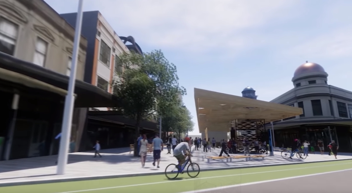
Karanga-a-hape
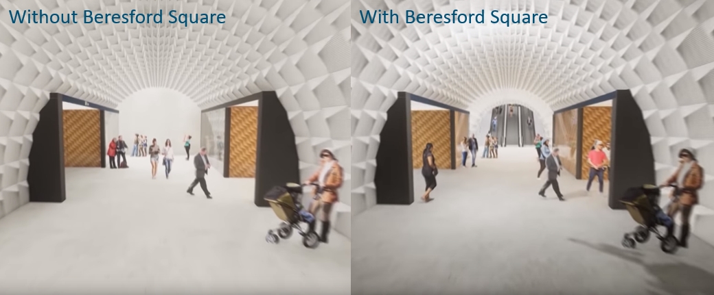
The video released previously gave the best visual yet as to how the station would look and feel but it only included the Mercury Lane entrance, which is notable given that less than a month earlier it was finally agreed that the station would be future proofed for longer trains and a Beresford Square entrance.
They’ve now released a new version with the Beresford entrance included.
https://www.youtube.com/watch?v=KXqko7pcVXM&t=250s
A few things I noted
- You can see where the Beresford Entrance joins the station underground in this before and after screenshot from the video.
- There’s something kind of special about a really long single escalator to get down into a station and that’s exactly what they show as planned for the Beresford Entrance
- The original plans for the entrance had a huge cavern of an entrance in a bid to try and get some light five storeys underground. The design now is simpler and I think it helps celebrate its status as Auckland’s only deep underground station.
- Previous plans for Pitt St had showed large ventilation structures in the middle of the road and on the opposite footpath. These appear to have gone. If correct then that’s another great benefit of building it all from day one.
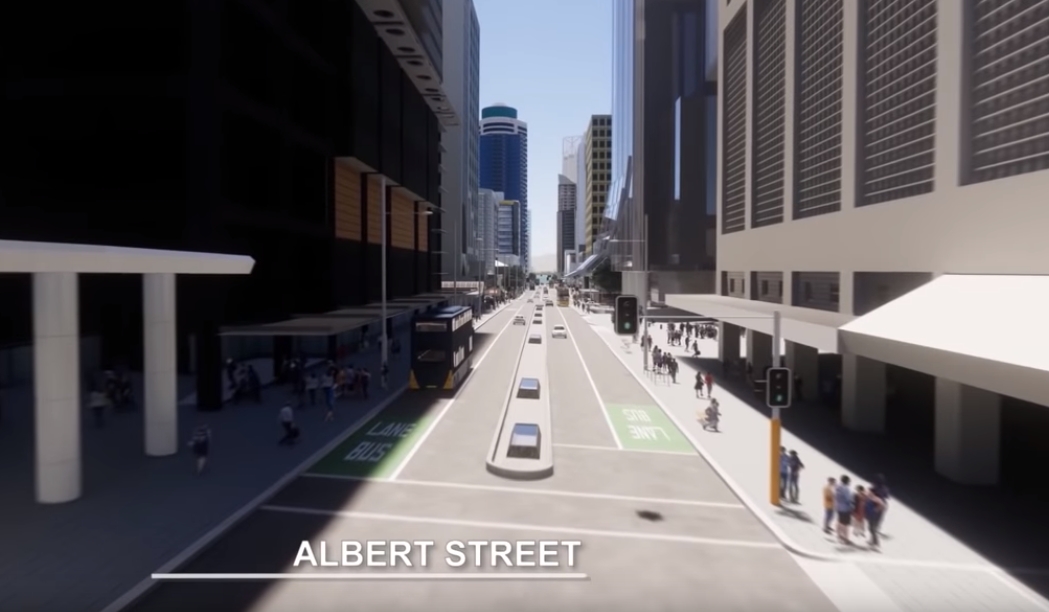
Albert St
We first saw a video of what Albert St would look like about 18 months ago but there’s been not a lot about it since then. The new video appears to just be a higher quality version of that and disappointingly hasn’t addressed any of the major flaws in the design.
https://www.youtube.com/watch?v=AaYC0bCznnk
Some thoughts
At about 20 seconds in, is that on-street carparks outside the main entrance to what will be the busiest train station in the city? Alternatively they could be bus stops.
- There is still a significant amount of space take up in the middle of Albert St for skylights.
- It’s unclear how much CRL will implement other council goals at the same time, such as the Victoria St Linear Park (more a plaza in this section), but if they are doing so, it doesn’t show in the video.
- As mentioned, the graphics in this video are prettier but are also more accurate. The previous version showed towering mature trees where none currently exist while the new version reflects the actual design which is use the space that should have been for trees for bus bays. This is problematic because as I’ve pointed out before, ATs own design standards say they shouldn’t be used.
Construction
While we’re on the CRL, there have been a couple of good construction videos released showing a timelapse of how the Albert St sections is being built as the process moves up the trench like a production line
and

 Processing...
Great to see a Beresford entrance, but am I right in assuming that the original tram station building on the centre island in Beresford Square has been demolished in the visualisation? Surely it would be better to incorporate this character building and charming part of Auckland’s transport (as well as public utility and wine bar!) heritage…
Uh sorry to burst your bubble, but that is a modern building from the 90s, built over an old public toilet. It’s nothing to do with trams, and while the old pissoir has a sort of character I don’t think you could claim it has heritage value.
New Zealand has a knack of building pubs in old public toilets – see the Welsh Dragon Bar in the middle of Cambridge/Kent Tce in Wellington
Rumblings about something in the ones on Wellesley street near the gallery….
Some amazing progress on Albert Street construction. But why do I have to wait until 2024 instead of 2021…. oh yeah…. it was a National Government with the fat controller who said this project was a waste of money.
If they need to save money at Karangahape Road then why not leave out the Mercury Lane entrance?
Good point. I hate it when you’re right…
Except that a single escalator will not cope with the traffic. It’s nonsensical to design any modern underground station with anything less than 3 escalators – one Up, one Down, and one that can switch direction according to traffic flow. Also helps to have 3 escalators when one needs escalators. It’s basic, Tunnel 101 sort of planning.
But its not a single escalator – its 3 side by side just as you say is required.
And why is Beresford unable to cope if Mercury Lane is not built, when the exact opposite design was considered suitable [Mercury Lane and no Beresford]?
To my mind, for now, the Beresford entrance is nicer than Mercury.
And until Mercury area is properly rebuilt Beresford is the entrance I would use.
So I would say if money is tight, hold off on the Mercury Lane entrance.
Sure do the foundations and such, just don’t kit it out or finish it.
Greg – my bad – I read the line “There’s something kind of special about a really long single escalator to get down into a station” and commented, before actually watching the video, where there are indeed 3 escalators….
It doesn’t always make sense to have your switching escalator. It will mess with flow, with people expecting it to be one way, and you have to have someone or something to manage the change. With no people on it.
The better option is to always have 2 running out, with 1 going in. People arrive to a station in dribs and drabs but trains bring big globs of people
I’m not sure that’s the case. You only need to look at Britomart where people arrive in a mass due to the pedestrian crossing of Customs St.
You get a couple hundred people arrive in a 30 second pulse, then almost nothing for the next minute and a half.
NZTA says best practice is for pedestrians to not have to wait more than 30 seconds in urban areas. A 1.5 minute pause between bunches of people arriving to the station, the traffic light phasing needs fixing. 🙂
What’s the point of having that number in the guidelines? A single green phase often takes longer than that.
A 30 second wait is about the maximum someone walking would feel was ok. It’s not like a pedestrian can drive away at 30km/hr once s/he does get a green. And the guideline is absolutely possible – it may mean having a pedestrian phase after every direction of traffic.
So I guess the point is, now that we have a government that understands the changes to safety and amenity required to increase active mode share, these details will need to be attended to.
Heidi, they might want to check the phasing on the lights in SH1 – Vivian St in Wellington then, where it crosses Cuba St. Feels more like 5 minutes between phases.
Maybe measure it, Guy (at different times of day, of course). I measured the crossing on Fanshawe St: 3.5 minutes. I’ve rarely seen anyone bother to wait in the middle; the phasing leaves the pedestrians stranded with no cars coming for a long time. They’ve set that one up to encourage walking on a red man, but of course we know what would get recorded if a pedestrian does get hit.
On GNR in Waterview it now takes 5.5 minutes (measured) to cross where NZTA refused to put in a pedestrian bridge. That’s in multiple legs, of course.
Heidi has work on the k rd station started yet, when is k rd station going to be open? Excited to find out
In the Albert St video they show developments that are actually proposed, however in the Mercury Lane video there are a few apartment developments I think are simply imaginary, including one on top of the actual station, I’m assuming CRL will not be building these. The apartment that forms the lane down the middle with nice restaurants etc looks great, but if not built by time stations are finished the reality could be a flash station in the middle of a light industrial area 🙂
Beresford looks great! Albert Street looks miserable
Beresford looks great, Mercury will take forever to meet the aspiration – I can’t see them ripping down the massive car park building any time soon and there’s little to like about the area currently holding Mercury Plaza. Perhaps it’s a vision of 15 years from now…
Jon K, maybe? Who would have envisaged this until it happened?http://www.colliers.co.nz/news/2018/federal%20street%20car%20park%20sale%20a%20market%20leading%20deal/
I only hope that more people start to envisage the sale of AT’s parking buildings. Here’s something that could really give a boost to public transport.
Perfect development opportunities for Panuku to buy/re-develop AT owned carparks I would think? Incorporating Kiwibuild in the process perhaps?
Interesting link, though not comparing apples with apples.
That site has potential and is in a desirable part of town. The Mercury Lane car park is next to a motorway and in the bottom of a gully. Mercury Plaza suffers from the same pitfall. Sure, the train station will act as an anchor for redevelopment, but this will be tempered by the motorway and poor views.
I’ll revise my prediction down to 10 years 🙂
That’s great news, taka-ite.
One level at least of the car park building (near K’rd) could be made an indoor bike parking facility. This could be bike central for south & west Auckland city. Britomart somewhere could be for east & north.
Auckland Council sold that carpark to Tournament Parking for $10million back in early 2003 IIRC. A year later Wilson’s bought Tournament for $90+million IIRC.
My point is: council sold the family silver so it’s gone now.
I hope they have budgeted a couple of bucks a day to pay the squeegee bandits to come and clean those light wells, cause at that height they are gonna get covered in road grime, dust and mess every few days,
Would be great to include covered, secure bicycle parking that, along with K Rd bike lanes, shows riding a bike to PT is supported.
I noticed on the Albert St video they didn’t really show any of the NDG Tower. I was under the impression that NDG Tower was going to have a platform too.
With regard to Karanga-a-hape station – Pineapple concrete? Really? Perhaps it’s just a filler for the video, rather than indicative of their intent. Also, call me cynical perhaps, but who else can see the escalator tubes covered in electronic displays within the first year?
The NDG owner most likely a land banking speculator with no intention to build. He probably just get a resource consent sell it off to another speculator.
If the council is smart they should start to charge a land banking tax.
I doubt that the NDG Tower is a land banking rort, but you are right – There is too much land banking and the council does need to do more.
Consents don’t last forever, they lapse unless used [normally 5 years but they can be granted for more or less time].
So any land banking with a site with a consented building is merely a short term thing as after the consent lapses its back to square one for the new site owner.
I’d say however they are waiting for CRL to open, then the site increases in resale value. Even more if they get AT to allow platform/station access via their building.
That empty site has been a train wreck and eyesore for over 30 years now.
But the land banker can abuse the process and submit resource consent alteration after 5 years – For example increase building density/height.
Upon successful, the land value will increase further and they can sell it to another land banker for profit. (and still nothing gets built)
The process repeats. That’s what happening in the last 30 years.
Oh, you mean like the building consent that had expired when Westfield sold the Downtown Mall to Precinct Properties? The consent the Council quickly reinstated so the sale could proceed, thereby forcing the same council to negotiate and pay handsomely for the rights to tunnel under the mall for the CRL?
A shame the council didn’t slow down a bit and negotiate both things together.
Why is it that both these video’s show a gentle slop running down all the main roads/streets leading to the entrances ? . Mercury lane looks as if it is just a gentle stroll to get to it
It’s really not as steep as people think. Granted if you have mobility issues it could be a problem but there are a lot worse in and around the city, like Victoria Street or the top of Queen Street. The climb from Mt Eden Station to Newton is likely to ensure anyone who does it regularly gets buns of steel.
Lol “…buns of steel.” As an aside upper queen st should get a light rail stop for this reason.
Albert Street is an opportunity to rebuild a street that befits the central city, including protected cycle lanes on both sides and continuous bus lanes. The skylights, a complete waste of valuable space need to go, as do the indented parking bays. The whole street design needs to take into account the the LRT plans of the current government which will mean far fewer buses from the West that would have been the case. Relegating people on bikes to crowded footpaths or shared spaces on Federal Street, whilst finding the space for dedicating turning bays for cars is the same old tired out of touch engineering that AT is renowned for.
Yes very disappointed about the proposed “redesign” of albert street.
It looks like more of the same – uninviting walking environment for pedestrians.
As I always says, if AT is doing the urban design, it is gonna sucks – like manukau.
What happened to the Stingray building design for Beresford Square that was originally planned? I thought it looked great. Also would be good if they incorporate an easier pathway across Pitt Street from the Beresford Square station to get to Myers Park or Greys Ave
Better yet an underground connection.
K’Rd/Pitt St intersection elevation is about EL65.5m. Station is 32m deep according to the CRL website, so this would be EL33.5.
The bottom of the steps, at the top of Myers Park is EL45m. This should roughly match the concourse level of the station, so a short access tunnel could easily emerge straight into the park at this point.
Yes definitely need subway to city side of Pitt St as the majority of passengers will be heading that way and would otherwise have to wait to cross Pitt St. To Myers Park would be great.Could future proof it to allow extension to Queen St.
I did not see the Victoria Street linear park depicted in the fly through, is that a deliberate omission?
The linear park is put of AT works and the reinstatement of Albert ST is CRL’s works and the video was created by the CRL , and there is a comment on their Fb page to that effect
Nice time lapse vids of the Albert St tunnels. They should be completed sometime soon.
So How will they be used the next 5 years until the CRL opens? Is there some reason these tunnels and the tunnels through to Britomart will be completed yet the rest of CRL is 5 years away? Is this a planning fail by AT then CRLL or just a lack of expertise in NZ to do this project in a timely fashion?
The first stage tunnels are being build basically because of the PWC tower development. The first part of the tunnels run through the basement of this building so it was either now or never. Auckland Council and AT basically signed off on that and made it happen.
The fail to have the main works going back to back is proabably most attributable to the previous government dragging the chain more than anything.
Big fan of natural light, but are skylights really necessary? No natural light is just part and parcel of being in a tunnel, underground. People know that, people accept that Seems unnecessary both in design and cost. Plus artificial lighting is pretty creative these days. Surely they could come up with something unique?
I’m not a fan of the skylights. I speculate this is from international designers who might be used to shuffling underground in the tube or other metros for hours each day. In that case natural light would be a huge bonus.
But for us we’ll only have the three city stations underground, a passenger will spend only a few minutes out of their trip under the earth before the train is back at the surface. I personally don’t think natural light to the platforms is important, I’d rather they focus on good pedestrian access and fast headways so you don’t need to spend much time waiting in the station in the first place.
Maybe they’re access points for rescue workers in the event of an earthquake.
Good point about the Beresford Sq entrance helping with getting light in, and I think a much more open feel as a result.
Currently outside the crown plaza hotel there is no footpath. https://goo.gl/maps/LqawMqiS5Ht
What looks like it is a generous width of cobbled footpath, separated from the road by planters, is actually a slip lane that cars speed along to enter the atrium car park.
At 55 seconds into the albert street video, they show this as a normal footpath full of pedestrians bathed in sunlight.
How have they achieved such a transformation? Where will all the taxis park? https://goo.gl/maps/szd9z1527QR2
Likewise at 1:04, this horrible parking bay / car park access lane / desolate dank windswept tower entrance to the Huawei building suddenly becomes a packed town square.
https://goo.gl/maps/B8rt28d4tgJ2
Are these guys doing the video render just making stuff up or are these city centre improvements that are currently in the pipeline?
It seems lots of people have learned the art of levitation! Amazing. We probably don’t need any PT if people can fly
I don’t understand:
What are those funny panels on the side of the tunnel walls?
And Why is there some off entrance jutting-out of the intersection between tunnels?! Why have anything there?
Compare that to the following:
http://www.crossrail.co.uk/route/design/