City Rail Link Ltd released videos yesterday showing fly-throughs of all of the stations being built or upgraded as part of the project. They really give the best view yet of how the stations will look and feel when the project opens, currently estimated in 2024. For this we’ll move South to North.
Mt Eden
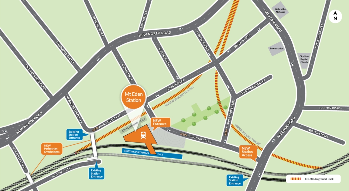
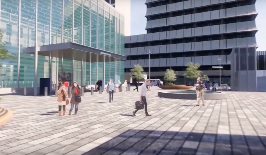
Mt Eden is the start of the CRL from the southern end and will see new platforms added for city bound services. The existing platforms will also be upgraded but they’ll only be in use for infrequent west-south service that we think should be dropped. The area is also going to look quite different with all of the surrounding land that will be able to be redeveloped.
Here’s the fly-through.
https://youtu.be/tmetv9JpKf0
The big feature of the station is the large sculpture wall – we’ve seen this before though.
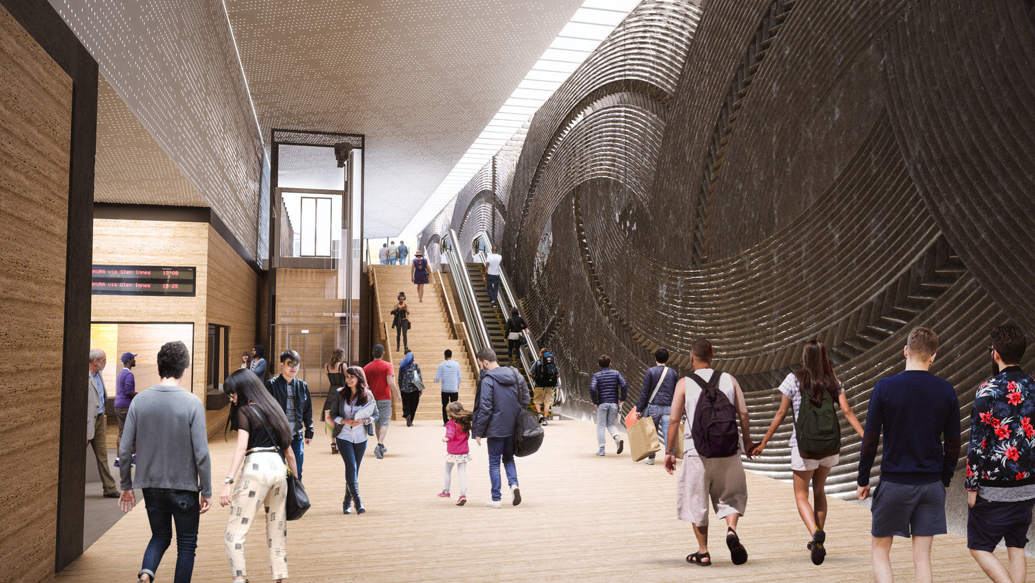
I like the authenticity that’s been added in with a couple of cars parked over what appears to be a shared space or footpath. On the station itself, while the inside looks nice, the outside appears as just a large grey box, surely we can do better.

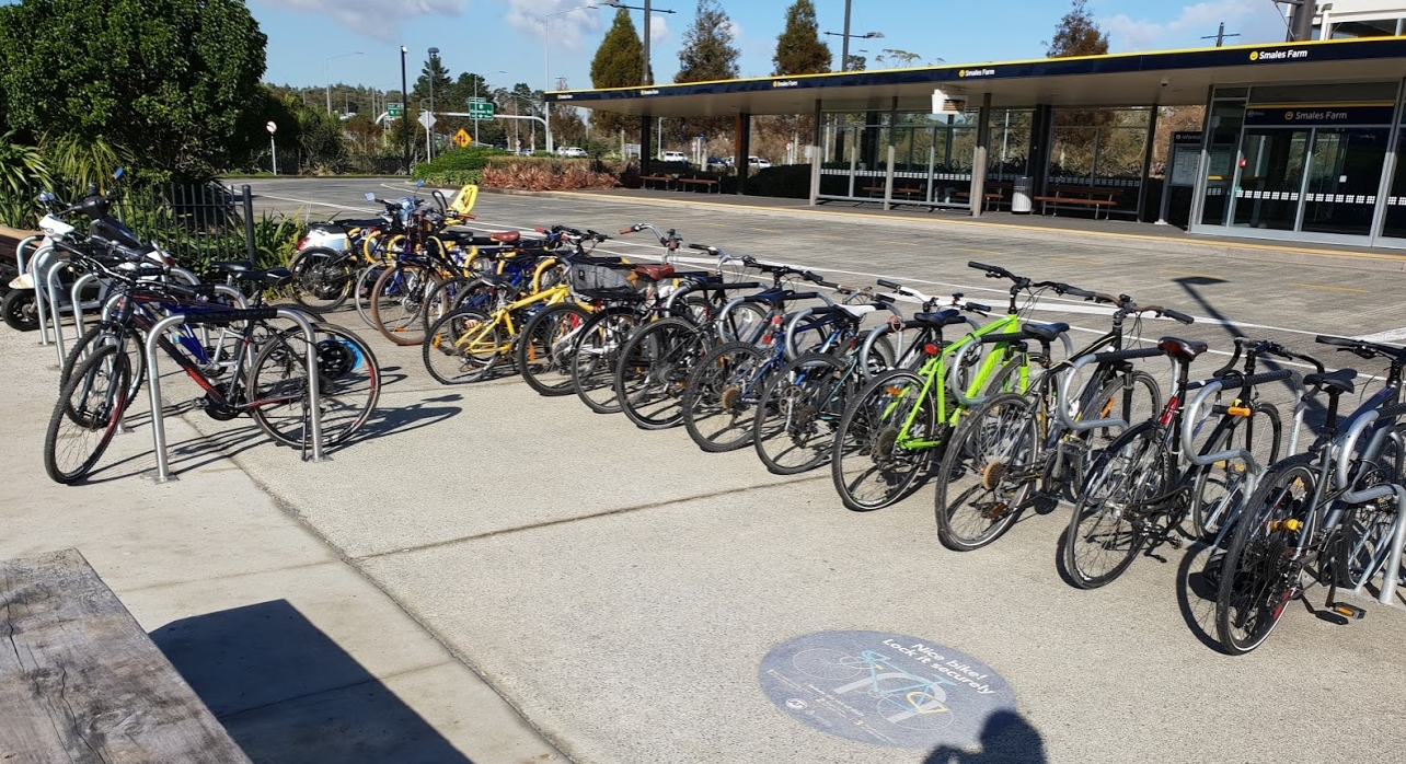
Then there’s that bike parking, why is there not an integrated and covered bike parking facility. And given what we’re seeing at the likes of Northern Busway stations, that simply won’t be enough parking. For example, this is Smales Farm busway station in mid-winter and I suspect Mt Eden would be busier.
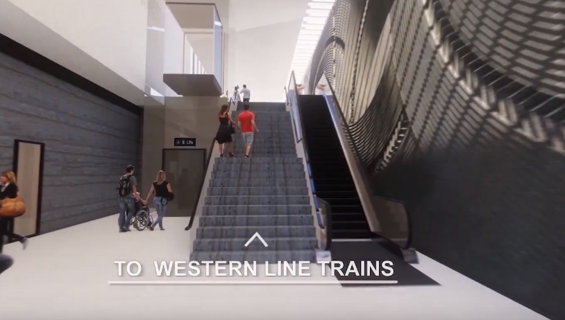
Back to Mt Eden, this may just be a video thing but it’s a little confusing to say “To Western Line trains” given that most western line trains will use the CRL platforms shown earlier in the video. On a more serious note, Why only one escalator here and from the CRL platforms?
Karanga-a-hape
We recently learnt that CRL will now be future-proofed for 9-car trains and that doing so will require the previously dropped Beresford Square entrance. Sadly the map below and the video don’t show the entrance as they were likely produced before the decision to future proof was made.
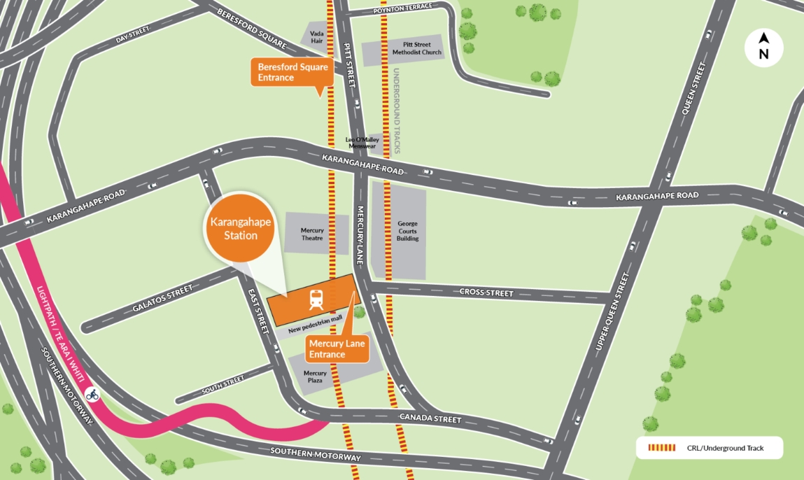
Karanga-a-hape will be the only proper deep underground station we have and so one thing I really like about the design is that it appears to celebrate that fact. Here’s the video.
https://youtu.be/qKx8eXu2HgU
The station will be one of the busiest on the network and the Mercury Lane entrance will have thousands of people flooding out of it, so it seems crazy that the proposal is still to dedicate so much road space to the movement and storage of cars. Mercury Lane should really be closed to traffic with adjustable bollards in place so emergency services or maintenance vehicles can still access the area.
Like with Mt Eden, there doesn’t feel like there’s enough bike parking and it should be integrated into the building. Karanga-a-hape is likely to be quite busy with bikes as people catch a train in to ride down routes like Lightpath.
Moving on to the station, after you’ve already been down two sets of escalators, you must be close to the trains …..
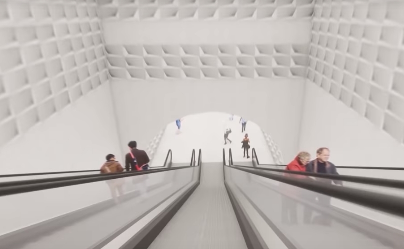
…. no, just a sub-level. This station is deep.
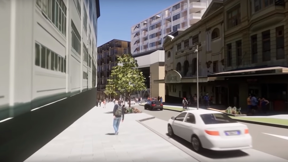
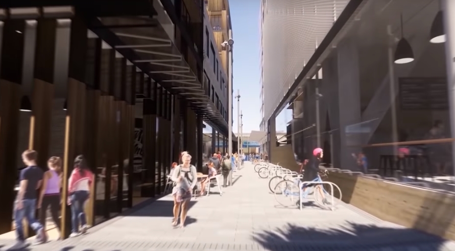
Like with Mt Eden, there’s likely to be a lot of redevelopment around the station and the new lane between Mercury Lane and East St will be a great addition.
With the Beresford Square entrance, this station is going to be great and really a one of a kind in Auckland.
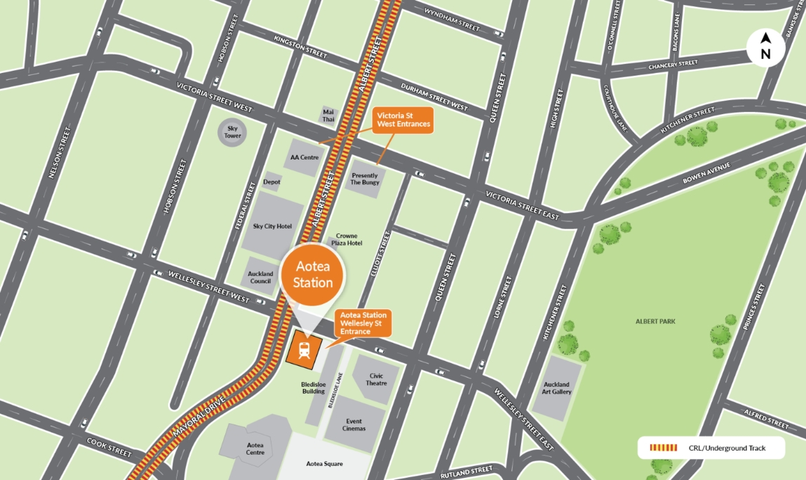
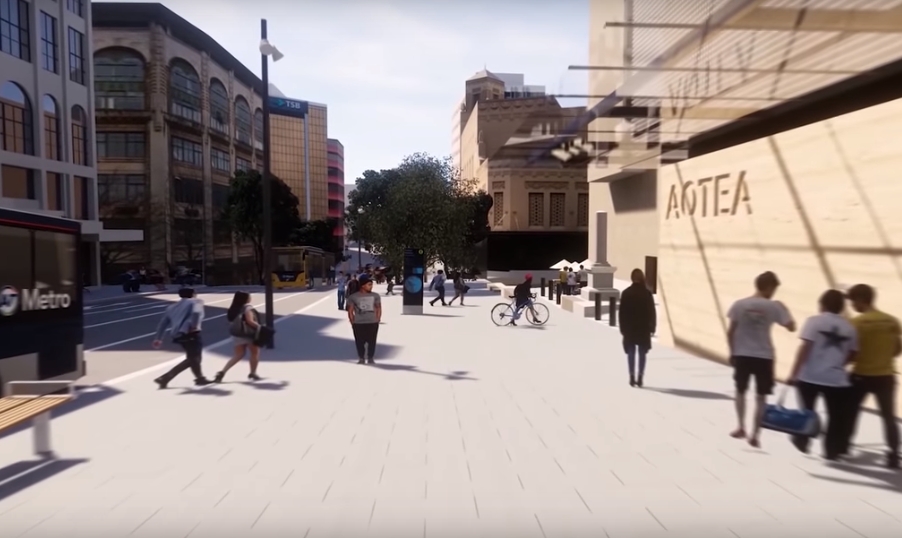
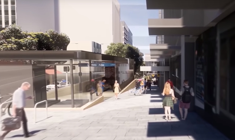
Aotea
Being right in the heart of the city centre, Aotea is expected to become the busiest station in Auckland. It could also have an office building eventually built on top of it.
Here’s the video
https://youtu.be/U6IF96IiSS0
I’m liking the much wider footpaths outside the station on Wellesley St. That will definitely be needed to help handle the volumes of people pouring in and out of the station.
Over at the other entrance on Victoria St, in the video you can see a placeholder for access to the planned NDG building in the currently empty lot on the corners of Elliot, Victoria and Albert Streets. I had heard that SkyCity were considering one from the middle of the concourse level but have since decided against it.
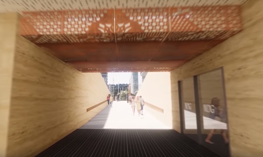
I can also see this entrance from Victoria St being used by people not going to the station but walking between east and west. It is essentially an underpass of the Albert St/Victoria St intersection and on the western side there are escalators back up to ground level.
Britomart
There will eventually be changes to the platforms and the eastern end of Britomart but they’re not shown in the video. Instead it shows the CPO building and the surrounding public spaces. These will also be some of the first we see as works in the area will be finished in 2019/2020.
The gates will be moved from the platform level up to the ground level in the CPO. the old raised section is also gone.

I’ve become quite accustomed to the temporary station entrance. It will be odd to see it go again.

 Processing...
I hope that some thought is given to renaming Mt Eden station. I personally would like to see it called Eden Terrace.
Even better, theirth looking to rename it Maungawhau
Why the suburb is Mt Eden?
Just the usual Virtue Signalling.
Pathetic terminology used by right-wing bigots.
Well, I do believe that Brutus Iscariot was one of the original right wing bigots. Ides of March, assassination of Caesar and all that. Seems appropriate….
Not really. Here’s what Google thinks Mt Eden is: https://www.google.com/maps/place/Mount+Eden,+Auckland/@-36.8822614,174.7372131,14z/data=!4m5!3m4!1s0x6d0d463612a11ff1:0x500ef6143a2e6e0!8m2!3d-36.8801967!4d174.7616499
So it’s right at the edge. I think of “Mt Eden” as the village, which is quite a distinct and different place. I think of the residential area and the volcanic cone as “Maungawhau”. But this area where the station is, I think of as Eden Terrace.
As a name, Maungawhau would be ok because it is the name of the closest volcanic cone, which is nice to mark. Eden Terrace would be ok because the urban form here is that of the adjacent Eden Terrace suburb much more than the adjacent Maungawhau suburb.
But Mt Eden as a name misses out, for me, because it’s indicating another place, and I think could be misleading.
+1
It will be Maungawhau. The Maunga is visible from the station, Mt Eden village is not. Get used to it.
Patrick: That seems like a really weak argument. The entrance to the mountain road will be a kilometre away from the main entrance to the station. If you follow that logic then Britomart Station could be renamed Sky Tower Station as it’s both closer and would be visible from the station save for the buildings in the way.
Really useful… giving it a name that makes absolutely no sense to 90% of the population and only minor to probably another 5%. So yeah catering to a tiny percentage of the population for what benefit?? Is a joke. Needs to be named after an either useful geographic location that people know well or another well known name.
Maungawhau is a stupid name and would just confuse people if you ask people in the street what that means they will give you a blank look. There is nothing wrong with Mt Eden keep as it is. Also makes more sense given its been in that area for a very long time.
That map just shows the NZ Post post code boundaries. They are not very useful for delineating suburbs, as they are just what works efficiently for nz post delivery routes.
E.g. that shows half of morningside is being in ‘Mt Eden’
I’m all for being more inclusive of Maori but I feel naming it Mangawhau would just be confusing. Personally, I think calling it Mt Eden Road or Newton would be better options. After all you’re most likely going to one of the those two places if you’re travelling to the station.
Raro Maungawhau ? (under the mountain…)
Agree Mangawhau is just too confusing I literally don’t even know what that means. Even calling it central would make more sense just keep it some sort of Mt Eden naming scheme.
Did you know what Britomart means before they created a place called Britomart around the new station?
Britomart was named after a ship of the Royal Navy HMS Britomart, whose crew undertook a detailed survey of the harbour after it had been decided to base the new capital here
I know the history, but that was my point. I know the history now, but only after the station was created with a ‘funny name’ that renamed the area by default. Before Britomart station was built nobody call the area Britomart and nobody new what a Brtiomart was.
If calling the station get an understanding of the meaning of Maungawhau into public consciousness, then job done.
Personally I think the station should be called Eden Terrace, after the place it is actually in already. But second best is calling it Maungawhau and creating a new name and identity for the area.
Mount Eden is a bad name for that station, simply because it’s not in Mount Eden by some definitions, or at best is on the very northern edge of the suburb.
I think Eden terrace would be much better than Maungawhau it just makes absolutely no sense to call it that. Its just not catchy like other station names lets not confuse people and just call it Eden terrace CRL will be complex enough for people without ridiculous station naming.
Why does it make no sense to call it that?
I can see it makes no sense to call it after an existing area that, for the most part, people seem to agree that station isn’t in. In that case calling it Mt Eden is wrong and confusing, because Mt Eden already exists elsewhere, a good fifteen minutes walk to the south. Likewise with Newton, in my mind Newton is the next suburb over, up over the hill. Newton is as bad as Mt Eden in my opinion.
But what is wrong about Maungawhau? I realise it refers to the same mountain, however there is no suburb in Auckland called Maugawhau so there is nothing confusing about creating a place called that to describe the new area around the station. And like Britomart, it will be effectively an entirely new place, and naming it in the process.
We could call it Blueberry Pie Station, and that wouldn’t be wrong or confusing, because after a couple of years as the new streets go in and the new buildings go up, the suburb around it would be known as Blueberry Pie.
Fair point but I just don’t see Maungahwau as a good name I could think of a ton of different names to use and Maungawhau. Eden terrace, New north, Central, Eden, Mt eden Rd the list goes on Maungawhau is hard to spell we want a simple name that people can easily say like “meet me at Eden terrace station”.
Maybe the answer is to embrace learning a bit of Maori? Maungawhau is a nice word to say, with gentle consonants. I far prefer the word Maungawhau to Aotea, which has two tricky vowel combinations and few consonants to give it strength. And I really don’t like Britomart, greek nymph and navy ship notwithstanding, it just sounds like a British version of Walmart, to me.
There are so many silly names for places in Auckland; Remuera being one of the worst; they removed a ‘w’ because it sounded too ‘Maori’; Point Chevalier being another – mispronounced French name of a military man who was good at target practice, diddly squat to that. Good names will tell a bit of the geography or history, and if that good name is in Maori, it has the added bonus of increasing knowledge of Te Reo.
In the case of Maungawhau, it brings to mind both the maunga, and suggests that there was a lot of whau here, which is useful knowledge in local native replanting schemes, as whau is a good pioneer. It’s also a useful wood in raft building, but given the central location of Maungawhau (away from the beaches) that has me wondering more. The volcanic cones were used by Maori for horticulture in a multi-decade rotation scheme. I wonder if whau grew here because it was a quick-growing soil-builder or if indeed they had another use for it?
The station isn’t right at the foot of Maungawhau, but it is a dominant geographical feature nearby, so it seems fine to me to use it as a name, and as I showed above, it has already taught me interesting stuff about the location, and posed some questions, too. All good.
It sounds like you just don’t like Maungawhau because it’s Maori.
I like the name Aotea its easy to spell and its a short name Im not saying there is anything wrong with Maori naming just really find Maugawhau really weird Eden terrace just makes so much more sense as people will know exactly what area it is in. Also saying it increases tereo knowlege makes no sense we already have over 10 stations with Maori names I think improving voice announcements in both English and Maori would be more beneficial for everyone.(Also is it just me or are the Te reo announcements really quiet)
Gee thanks Heidi, I didn’t ever relate Britomart to Walmart before now & can’t get that out of my head. Sounds cheap and nasty now.
He he
Totally in Eden Terrace, and the area that has more recently been branded as Uptown.
The station is too far from Mt Eden/Maungawhau domain and “The Village” to not be a very confusing name for the frequent tourists and anyone not local to the area.
Mt Eden plans continue to show two pedestrian overbridges at the western end of the station within 50 metres of each other… surely one will suffice?
Nort are needed if we don’t want to cause severance.
Yes, and I’m hoping that Fenton St will get some pedestrian amenity, too? This doesn’t quite cut it: https://www.google.com/maps/@-36.8682683,174.7568263,3a,75y,102.53h,64.84t/data=!3m6!1e1!3m4!1sb8W1XpBfCrb5eOT9nvJCxA!2e0!7i13312!8i6656
The stations in those renders (particularly Aotea) look very ’empty’, just simple through-fares. Not a single coffee shop in sight (or anything else for that matter for people to stay around for). I guess perhaps AT doesn’t want people to linger around, but I do hope that that it will end up looking more inviting.
In the afternoon peak, Aotea Station will have in excess of 1000 people on the platform. There won’t be a lot of spare space.
I agree about the platforms, but I still think that the councourses would benefit from having some form of retail. At least in most of the European cities I’ve visited (and lived) the main stations are not just simple transit points, that brings a lot of life to the place.
How many places do you need to be able to buy a coffee at? Aren’t there another 500 coffee shops in Akl? Can’t you hold on for another 5 minutes?
It’s more about walkability – having points of interest along the way. Hopefully there’ll be busking and art works, but at least places for informal market stalls would be good.
When it comes to coffee, no we can’t wait 5 mins! Some little kiosks would be good. Panmure has this now inside but no seating for a much slower serviced station with tonnes of room.
“no we can’t wait 5 mins!”
Don’t get between an addict & their fix.
(Says I, who is heading off for coffee now… Got to make it through to five in a somewhat productive state.)
When we are walk in a blanked wall boring tunnel we will feel the walk is a long walk than it actually is.
Where if we walk in shopping mall for 10 minutes we will be eager to walk more.
The passage should at least have some kind of interesting stuff happening.
For example it would be interesting to walk if we have electronic billboard that advertise the new alien vs predator movie; an upcoming event like baby show; some kind of annual sale from Smith Caughey; some guy handing out Uber eat coupons; a free energy drink sample.
If we like something less commercial, we could display popup Art and photography. We could advertise the upcoming free family event from Auckland council. ASB could hire some Busker to give kid a free balloon.
The point is, we don’t want a long plain passage with nothing to see.
Heidi says “places for informal market stalls”
Do you mean space for hawkers and hustlers interspaced between buskers, beggars and reclining homeless?
Or something informal yet organised? Perhaps policed by transport officers?
Bogle, what do you suggest regarding policing? Informal yet organised sounds good. Commercial and non-commercial activity that isn’t bland chain store / big business, like a young jeweller not yet up to owning premises, booths selling vege soup and hotdogs. A community group selling some excess grapefruit and lemons so they can fund their outreach to plant fruit trees in poorer areas. Spaces for performance. Seats around a drinking water fountain so mothers can breastfeed where there’s enough to watch while the siblings are waiting. A coffee shop for Grant. And maybe some students of reflexology giving $10 foot massages. 🙂
+1 Heidi
Yes Aotea will be a nightmare at peak probably like town hall in sydney Crowded, Hot and crazy also wonder how it will cope with big events in the city if everyone rushes down to that platform at the same time
Yes, in particular the Diwali festival will be a great test for Aotea station.
Can already see the disaster Everyone rushes down to catch their train announcements aren’t clear so people get on the wrong train, Platform gets overloaded, Station closes everyone ends up on a bus, basically how every event in Auckland seems to go.
Auckland Trains what is the hardest thing to just stop looking at that stupid piece of plastic in your hand and look at the destination board on the side of the train . They have to do it with a bus why can’t they do it with a train
This is if the destination board glitches and we have to rely on voice announcements which happens surprisingly often. (was on the train and said next station Henderson even though we were arrving at fruitvale road) But most of the time the destination board should work. Im just more worried about platform overcrowding after an event could be dangerous.
Yes they will probably not even use it, lol Too dangerous like Parnell station for ANZAC parades.
“…The big feature of the station is the large sculpture wall – we’ve seen this before though…”
this sort of Philistine, brain dead approach to “art” completely triggers me. It sums up modern corporate culture and it’s self-serving lip service to progressive values like indulging in green washing, or banal art, or putting in a lift for the disabled… at the bottom of a steep road.
I loath corporate chicken shit “art” like this. It is a sprawling and vulgar waste of money. If you are going to design a utilitarian grey box of a building then don’t try some lame homage “culture” by getting a piece of crap stuck on the wall by some nobody commercial artist or another. Just get some pressed concrete molds. Nobody is going to linger to admire it anyway.
If you want to make a urban space statement via art in your metro stations, then bloody well make a statement via art and design the station as a piece of art – look at the Moscow metro – https://www.amusingplanet.com/2013/05/art-and-decor-of-moscow-metro-stations.html
We used to be proud enough of our government building as symbols of progress to make the effort to make them beautiful as well as functional, even lowly electrical substations and pumping stations built in the middle of the last century are housed in building that contain Art Deco flourishes – just look at the magnificent Auckland Old Railway Station, it must have been a beauty in it’s day.
Apart from that, great to see progress and the sooner the whole lot is built and up and running the better.
I don’t know if nobody would stop to look at it, the blue wall with the bubbles in the PWC building people stop and look at it all the time, i look at it everytime I pass through.
While somewhat rambling, your comment made me chuckle and if I understand you correcrly then I tend to agree. Rather than adding art lipstick to pig buildings, I’d much prefer we designed buildings that were inherently beautiful. Thing is, that seems to be much harder than art liptick.
The balance this time between exterior and interior does seem to be out of whack. Though I’d like it if someone pointed out a beautiful architectural exterior that I’ve missed. I’d prefer to be fully enthusiastic…
So are you suggesting chandeliers, stained glass and nationalistic murals?
In the Moscow example he gives, the beauty is provided by the architectural form of the ceiling and archway shapes, repeated for continuity without slavishly being copied, by the pleasing connection between spaces, by the use of traditional Russian motifs, and by the interplay between the actual materials used.
For these designs in a modern NZ context, I think they’ve done quite well in some of the interiors, with repeated forms and spaces that interconnect reasonably well. Overall, though, the exteriors look like boxes, and that’s what leaves the impression that they’ve taken a box and stuck some acoustic dampening to the interior of it.
In building 302 at UoA there’s this completely incongruous Greek looking art piece. Which is to say the murals wouldn’t have to be relevant as long as they look good. Karang-a-hape in particular is screaming out for something in this order… although, I would suggest dragons and taniwha because the elongated forms would flow well with the endless escalators.
Hell, you can make them educational murals.
The coffee stands suggestion can go, though. The stench of that stuff is quite intolerable.
Do trains heading from Aotea out West jump on the right hand track to get back around? Wouldnt this be a massive bottleneck? Cheers
The usual failure by the CRL comms team to understand their own project is at fault here: There will be dual track in each direction into/out of the portal, not just one as shown on the map above.
The stations look suitably vast, built for far bigger numbers than I think Auckland would ever see with the current limited heavy rail network, it really does look like they were build for a far larger network than we are ever likely to have.
Aotea deserves a heavy rail line from the North Shore to fill it up!!
Given the normal underestimation of Public Transport volume, I think they’re underestimating the space required, particularly on the platform at Aotea, it doesn’t look that wide at all.
You obviously don’t support the plan to lengthen the platforms to take nine car trains then.
Urban rail systems are 100+ year investments, it is way way better to build for more than fewer users now, than have to come back later and rebuild the whole thing.
Additionally all future estimates are wrong. And all this century they’ve been wrong in one direction; under-calling it. So the risk is clearly in the other direction.
I like how there’s very few people over 25 in the videos. Older people walk so fast. I like to trudge along, head down looking at my cellphone, forcing others to walk around me and oblivious to those I’m bumping into and cutting off.
Stirrer. No one is walking fast in these videos. And lots of people are walking fast towards walls, which I find quite funny.
There is a white haired older guy with a backpack on that for some reason I have noticed at just about every recent artist impression they have used. See the Rosedale Busway Station pics for example.
Lol in the Britomart one he’s in twice in short succession, he has a double!
You’re absolutely right that Mercury Lane needs to be closed between Cross Street and K Road. Ruru Street also needs to be closed to all vehicles from Flower Street to Nikau Street.
Though these fly throughs also highlight just how ridiculous the height limits are at K Road and Mt Eden. Mt Eden will be part of the city centre once this is built and should have height limits removed.
Yes. GA have pointed this out for so long. It is so basic, and so important. What’s keeping them from making the change? Has there ever been a statement of why the cars still need to waste that critical space?
Would it be something to do with the sacred “viewshafts”?
I was replying to the closure of Mercury Lane to vehicles, not to the removal of the height limit.
The current excuse is emergency vehicle access; like the rising bollard had never been invented. Just TE foot dragging, and power assertion, mixed with the usual status quo warriorship….
Sounds like we need Opit and Witten to interview some people then. Maybe the TE will say “Pedestrian areas are dangerous things – dangerous, dangerous, dangerous!”
No I still believe he was misquoted. It should have read “Pedestrians crossing are dangerous things – dangerous, dangerous, dangerous.”
That would explain why you’d want to limit the space you give them. 🙂
Thats such a pathetic argument. Did whoever made it even manage to keep a straight face? The most likely emergency at the station is a traffic collision!
It was what I was told by the CRL liaison person at one of the k’rd meets with yes, a straight face. I’ll ask again next week.
A possible reason is that there is a vehicle entrance for a decent-sized apartment building on Mercury Lane, between K Rd and Cross St. I suppose this problem could be solved by giving residents keys for the proposed bollards, or by modifying the building to provide access from Cross St (which will presumably remain open as a service lane even if Mercury Lane is pedestrianized).
Make it a shared space, but closed to traffic at the top. In and out from the bottom only.
Then the apartment garage has access via Cross Street, and nobody has any other reason to drive on the bit of Mercury Lane between K Road and the station.
Job done.
Sounds like you’ve just designed a nice taxi park.
Where’s the mobility access in those renders?
At least 3 interior renders above show lift access & one shows a passenger in a wheelchair…
All stations will have step free access
I see ramps and elevators
I’m confused by the appearance in Karangahape Station of what appears to be giant bites out of the inside of a pumpkin, in the ceiling above. Why ? What is the pumpkin doing floating above the entry and why has it been partly eaten? What is holding it up? Has the rest of it been made into soup?
“Moving on to the station, after you’ve already been down two sets of escalators, you must be close to the trains … no, just a sub-level. This station is deep.”
Deep? I was expecting the bridge of Khazad-Dûm at the end of the third set of escalators!
It made me look at the details about keeping kids safe from falling by having generous upstands at the edges of level changes, instead of the minimum, and getting stuck between the escalators’ hand rails and the walls… I wasn’t that impressed…
Now THAT would be a great theme for a train station! Get Weta in now! 😀
Noooo! Not more bloody Weta ! NZ’s answer to everything – get Weta in and make it out of sculpted polystyrene.
Actually, you know what? Let’s not get Weta in. Let’s actually do some architecture, by architects.
+10,000,000
It makes me worry that people will simply not want to use a station that deep, for claustrophobia reasons. I doubt it will be very busy.
Parliament Station in Melbourne is pretty deep and doesn’t have any issues with patronage, and there are stations on the tube that are significantly deeper.
It would be a minority of people who would avoid these stations for this reason.
St Petersburg has some crazy deep stations, it doesn’t stop Russians from using the network, we kiwis are supposed to be brave people, it should be a problem, if it is there’s always a bus or you could drive.
https://www.amusingplanet.com/2017/03/the-deepest-metro-stations-in-world.html
Whatan absolute load of bs! This station is not even deep. I’ve used the metro in Moscow, St Petersburg, Kyiv and Tbilisi, and some of the stations they have are the true meaning of deep. Oh, and Daphne, thousands and thousands of people use said metro stations everyday. Doesn’t seem to concern their citizens.
All that flash paving will in no time be covered in chewing gum, which seems to be an Auckland specialty.
Zero tolerance is needed.
100 lashes for chewing gum! Death Penalty for public urination!
100 lashes and 2 hours on a water blaster!
…how about waterboarding?
The thing I find really baffling about K-Road station is that after a walk down mercury lane you are faced with having to walk up steps to get into the station….. ( yes there is a ramp) but then you go down a series of escalators,
Surely it could have been possible to have the floor level at a height that you don’t have to climb to get in…..
Exactly! But for this, they’d have to remove the priority give to the car.
I can’t watch the video right now but might it have something to do with preventing station flooding during heavy rain events? You definitely don’t want floodwaters in your underground railway system.
Important to get right, but it wouldn’t be hard. It would involve a raised platform, I think, which is easy to drain, and or course, making a feature of that drained water could be a really fun design. The graphic for the Victoria St entrance that Matt has included in the main post raised warning bells for me on the subject of flooding.
Yes could be fun with some boogie boards. I wonder though if that darker area once it’s under cover is a grating type flooring area to a drain? I guess a lot of details won’t be really in the videos anyway and will still be getting refined.
At least the station will be well drained, what with two 3m diameter pipes draining it.
Not sure what that means for Britomart at the bottom of the hill but!
I watched the videos before reading your post, Matt, and noticed the same things you did. I was instantly struck by the lack of covered bike parks. If they’re designing it well, the approaches by bicycle will have influenced the basic layout of the surrounding streets as much as approaches by foot. But if they’re designing it well in this way, we’d be seeing covered bike parks, so it’s kind of a flag that maybe not all is well in the overall modal picture influencing the design…
Picture AT 5 years ago – that’s CRLL
The bike racks on the new lane to East St look tacked on. Where they’ve put them, the bikes block half of what is a fairly narrow lane. I’m sure they can find a better spot than that.
Now if they design the racks so that the bikes can be parked at an angle there would then be less space used and they would also be easier to get in and out , similar to the way cars used to be parked in the days of old
Looks good. I would like to see more timber used and plants and water features added to soften all that heavy concrete feel.
I am pleased to see that they have reverted to Aotea for the middle station after flirting with Waihorotiu (the name for the stream that used to flow down what is now the Queen Street valley). This iimportant name should be reserved for something actually on the old stream alignment (perhaps one of the Light Rail stations) rather than something some distance away.
Similarly, they were considering renaming Britomart as Waitemata but seem to have reverted to the current name. I am all for greater use of Maori names, but do not think that this has to be a universal principle.
And they will try to rename the station at Mercury lane Karanga-hape and guess what will happen is that everyone will possibly still call it K-Rd because that’s where everybody will heading to anyway
I do wonder about architect renderings sometimes and how hard it must be to produce an authentic view.
That’s a nice bright sunny new lane between Mercury Lane and East St, pictured.
Just how often will the sun be shining the full length of the lane between the buildings each year? And I imagine it would only be mid-morning given the direction of the lane?
What isn’t, and never is, shown in architectural renditions is realistic weather conditions.
The reality is that Auckland’s climate is wet and unpredictable. What do we get for protection from rain? At best glass tutus high on the walls of buildings where they will be pointless in typical Auckland weather. If we are to lure people from their mobile rainproof bubbles (cars) realistic shelter is needed. Queen St shops were built with awnings for a good reason.
Yes, this is a biggie for Auckland. Between the sun, the wind and the rain, we’ve got some climate requirements that aren’t being addressed. I notice that AT and other buildings in town offer plastic bags for your umbrellas, which isn’t a bad idea. If they have organised soft plastics recycling bins as well, they need to be more obvious. And there are useful cultural practices we could encourage – that it’s ok to carry a spare pair of socks and shoes so you can have dry feet all day, or to keep a pair of slippers at work or school. Lots of kids were wet all day on Friday from their raincoat line down, because it bucketed down just as they were going to school. That’ll probably transfer to sickness next week and to parents driving them next time, if it looks like rain…
Well not too bad overall, must look again on big screen later to night. Will be good to get the old Britomart front entrance back again & walking straight through to the Northern Express buses will be great giving you the ability to make a real fast transfer if you want to.
..but yes more cycle parking. In the screenshot/video that new lane between Mercury Lane and East St showing tables & cycle parking looks a bit squishy in the way really. Haven’t really thought about it, but a decent covered bike parking facility around the K’rd Pink Path area maybe good, people could lock them up there then carry on in the train if wanted without their bike.
Yes more on this, that area will be a key cycle point with the Karangahape Rd enhancements coming, NW & Lightpath Cycleway popularity. I guess Britomart will also be with Quay St/Tamaki Dr & ferries etc.
Wonder what the bicycle parking at the hospital is like, too? 🙂
The video does not give the impression of how steep Mercury Lane is.
Common to all, I thought the walk distance/time to platforms was very long. Surely longer escalators could be used to remove transitions, and the distance between street to escalators to platforms could be reduced.
There should be at least a couple of shops at each of these stations, things like: 7-eleven, fast food, cafés, dry cleaners, internet cafes, hairdressers, banks, ATM’s.
Or more stations!
Also with the views at Aotea coming out at Victoria and Wellelsy st’s they also show both streets to be almost level .
I thought the big wooden box (right side at 0:40) is a waste of busy street frontage. I’d expect a shop, or anything there, instead of a blank wall. Maybe it’s just not on the render.
Can’t wait for this to be finished as I live near K Rd station. Just a question: are the tunnels high enough to take double decker trains similar to those in Sydney? I’m sure the link will become too crowded before long.
Looking at the height of the tunnels they are only designed for a singe decker carriage as per this link under the commerical bay buildind :-
https://static1.squarespace.com/static/58c503e81e5b6c367860f34d/t/5aced1718a922debacf7253e/1523503495709/Precinct+inside+tunnel+9+April.jpg?format=1000w
No, none of the New Zealand rail network is large enough for double decker trains, our gauge doesn’t allow it.
To do double deckers you’d need to raise every overbridge, tunnel, portal and underpass on the network, modify every station and rebuild all of the overhead. That means Britomart, New Lynn trench, Parnell and Purawera tunnels, and something like thirty motorway and road bridges. No way that will happen!
They have now allowed for nine car trains however, so those single deckers should hold about 1200 people each. If the link is full with those kind of trains running every two or three minutes in both directions then good job, and time to build a second one!
Or beef up the Light Rail network.
Probably get my head bitten off for this but I think you guys are over-reacting to the street on Mercury Lane. The render shows the road looking a lot narrower than it currently is, with a much wider footpath area. That’s a pretty good improvement I would’ve thought. A much narrower road should, as this blog has mentioned itself dozens of times, calm vehicular traffic.
Matt, the map for Karanga a Hake Station does show the Beresford Square Entrance.
I concur about the bike parking. People doing the project (and at AT) don’t seem to understand it rains in Auckland more than 20-30 times a year.
Matt, I want to ask about two things you didn’t comment on. One, while it looks like there’s pedestrian overbridges etc, is there actually only the one, main entrance on Ruru St for the Mt Eden Station? Or will some of those acess ways lead to other entrances not indicated on the map?
Two, I thought it was strange that the fly through for the Aotea Station’s Wellesley St entrance, went a way down Wellesley St towards Qn St before entering. Made it look like you can’t enter into the station directly right at the corner. Or maybe the fly through did it that way just to show there will be a lane next to tne station?
Someone else already wrote it, but I still think the platform ar Aotea looks a bit on the narrow side. At least the contract for Britomart East includes removing one current platform at Britomart and making the others wider.
I noticed that it says there will be water feature at Mt Eden Station. Hope it works better than the one at Britomart did. I still think there should be a fountain/water feature in the public space in lower Qn St outside Britomart.
I won’t bite your head off, because it’s always good to have a reality check. I do get tired of the expectation to be grateful of small increases in pedestrian amenity when we’re talking about needing to retrofit a car-dominated pedestrian-unfriendly city. I don’t think those widened footpaths will be sufficient for the pedestrian numbers we’ll see, particularly in the CBD where width is required for all sorts of social activity. And I think that on such a slope there will be much more variance in pedestrian speed, meaning there will be a need for more overtaking space.
At this location, even if there must be a lane for traffic (and I don’t accept that there must), they don’t need such a wide lane, and they don’t need the parking bays. What would be wrong with a minimum width lane (less than 3m wide), double-kerbed each side in a way that wider emergency vehicles could use the intermediate level, which works as a door buffer zone at other times. If a driver needs to park for a moment to drop someone off, they can hold up the car behind. Surely traffic flow isn’t a design consideration in this location?
Agree. Closing the street would be a bit radical in Auckland but I don’t see any reason why we must have a car lane there. And if we want a kiss & ride surely Canada Street will be close enough. How many people would drive to that station anyway?
For bike parking surely we can carve out some floorspace of one of those parking buildings. The render shows bike parking on the footpath in front of the station. That is a stupid idea.
Why aren’t there platforms for the tunnels between Grafton and K Rd? They could sit adjacent to LIFE church (around where the thin park is shown on the map above), forming the third side of a triangle with the other two sets of platforms. There could be an easy interchange with trains going between Kingsland and K Rd, which could remove the need for the service between Kingsland and Grafton (the upper level platform) and would simplify service patterns. It would also allow an interchange between the Southern line and the Central line (Dominion Rd LRT), assuming appropriate pedestrian links were built.
I love how in the ‘approaching the KRd station from cross street’ segment, they start off driving down the middle of cross street, then they mount the pavement and drive down the pedestrian mall. Surely the car will take out all the people sitting at tables and chairs. Is this a terrorist training video?
Or is cross street being turned into a shared space and they just forgot to remove the road in the rendering?
The CRL have added an update to their FB page and website about the Beresford Sq entry and with a new/updated video and it looks good/great .
https://www.cityraillink.co.nz/auckland-city-rail-link-crl-train-stations/