Part 1 of this series summarised the history and progress of the 4 RONS projects in Auckland and the Waikato, while this post will cover Tauranga, Wellington and Christchurch.
5. Tauranga Eastern Corridor
The Tauranga Eastern Link was another of the faster moving RONS projects and is only the second RoNS to be fully completed. This was a 21km, $455 million project that created a new offline motorway to the east of Tauranga, bypassing Te Puke. Around 15km of the project is also tolled with light vehicles paying $2 and heavy vehicles $5. The most recent numbers (for 2017) show that around 10,000 vehicles a day are using the road. It was also one of the first to have a 110km/h speed limit applied.
This project started construction in 2010 and was completed in August 2015.
Total Cost: $455 million
Road Length completed: 21km
Road Length under construction: 0km
Road Length not yet started construction: 0km
Verdict: design, consenting and construction all moved relatively quickly, meaning this was one of the earliest RONS projects to entirely finish.
6. Wellington Northern Corridor (Levin to Wellington) – SH1
The Wellington Northern Corridor consisted of series of motorway projects designed to create a near continuous motorway from Wellington Airport to Levin. It can split into two distinct sections – Tawa to Levin, and the City Centre projects and each have had quite different outcomes.
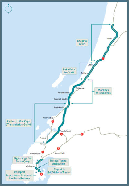
Tawa to Levin
The Tawa to Levin sections consist of the following projects:
- Transmission Gully – $850 million (PPP) – this is a 27km motorway that creates a new inland northern entry to Wellington. This was also the first transport project to progress as a Public Private Partnership. Construction started in September 2014, with opening scheduled for 2020. However last year it was announced that the amount of earthworks needed, was underestimated by nearly 50%. It’s now estimated that by the time it’s all complete there will have been almost 9 million m³ of earthworks – more than any other roading project in NZ.
- Kapiti Expressway
- Mackays to Peka Peka – $630 million – an 18km section of expressway that started construction in December 2013 and was opened in February 2017. It’s had a few problems since then too with parts needing to be re-sealed and noise issues for neighbours.
- Peka Peka to Otaki – $330 million – A 13km extension to the expressway, this section started construction in July 2017, with completion estimated in late 2020 or early 2021.
- Otaki to Levin – this section has progressed very slowly. In 2012 the NZTA announced they would scale back plans to an upgraded 2-lane state highway but last year went back to a 4-lane option. Earlier this year they released some short-listed route options but as of yet, no route has yet been selected. Recent news reports have suggested 2022 is the earliest construction could start, so that would mean an earliest possible opening date of around 2026. The latest price released was between $690 million & $1.05 billion.
The sections will deliver about 84 kilometres of expressway for a cost of between $2.5 and $2.8 billion.
City Centre
The City Centre projects in the Wellington Northern Corridor aimed to upgrade around 5 kilometres of road to create a 4-lane highway from Wellington Airport to Wellington City Centre. They originally consisted of following projects:
- Ruahine and Wellington Street widening
- Duplication of Mount Victoria tunnel
- Basin Reserve flyover
- Duplication of the Terrace Tunnel
These projects were costed at over $800 million in 2013.
The Basin Reserve flyover was the first of the projects to progress to Board of Inquiry Stage, however the BOI denied NZTA consent for the project in July 2014. An appeal to the High Court by NZTA failed. The project was officially scrapped in September 2015, leaving nothing to show for $12 million spent on design & consenting. The failure of the flyover to get consent, caused the whole Wellington City Centre programme to be upended. Here’s what NZTA have to say about what is happening now:
In the wake of the Basin Bridge decision an alliance has been established between Wellington City Council, the Transport Agency and Greater Wellington Regional Council to develop an integrated multi-modal solution for Wellington’s transport needs. The focus is the area from Ngauranga Gorge to the Airport, encompassing the Wellington Urban Motorway and connections to Wellington Hospital and eastern and southern suburbs.
Called Let’s Get Wellington Moving this alliance has a programme to develop and consult on recommended scenario/s by early 2017.
While this is being progressed, all previously planned improvements on key parts of the network have been placed on hold, including the Mt Victoria Tunnel Duplication project.
Let’s Get Wellington Moving again came out suggesting large scale roading projects however the public have continued to show strong support for PT, walking and cycling improvements instead. It’s not known when we’ll hear more.
Total Cost: Tawa to Levin – $2.5-2.8 billion, City Centre – Unknown
Road Length completed: 18km
Road Length under construction: 40km
Road Length not yet started construction: 31km
Verdict: Only one of the eight initial projects is actually open with another two under construction. The city centre area has seen no progress due to the failure of the Basin Reserve flyover project. Clearly the biggest failure of the RONS projects so far.
7. Christchurch Motorway projects
The Christchurch Motorway projects are a series of projects aimed at improving the northern & southern access to Christchurch, as well as providing an improved bypass to the west of the city.

The projects consist of the following:
- Christchurch Northern Corridor – $240 million – At around 7km in length, it provides a new northern arterial access to Christchurch, as well as a new link to QEII Drive. Construction started in 2016 and will be complete in 2020/21.
- Christchurch Western Corridor – The western corridor projects consisted of six different projects that aim to create a 4-lane expressway along the north-western edge of Christchurch. There were three major projects which were as follows:
- Western Belfast Bypass – $122 million – A 5km bypass this started construction in 2015 and opened late last year.
- Russley Road (adjacent to the airport) – $112 million – this involves building a large flyover at the main intersection outside the airport. This project started construction in 2015 and is due to be completed in early 2018.
- There were also 4 minor projects (each under $50 million), 3 of which were constructed between 2011 and 2013, with one due to complete later this year.
- Christchurch Southern Corridor. This consists of two stages to create a motorway between Rolleston and Addington:
- Addington to Prebbleton – $140 million – This 10.5km long project included a mixture of upgrading the existing motorway west of the city, as well as building a new offline section. This project started construction in late 2010 and finished in December 2012.
- Prebbleton to Rolleston – $195 million – this will extend the motorway a further 13 kilometres to the southwest to Rolleston. This started work in late 2016 and is likely to finish in early 2020.
Total Cost: Overall the Christchurch motorway projects will deliver around 51 kilometres of new & upgraded motorways for just over $900 million.
Road Length completed: 28km
Road Length under construction: 23km
Road Length not yet started construction: 0km
Verdict: Reasonable progress had been made with many sections open, however like many other RoNS we will have to wait until 2020 for widespread completion.
SUMMARY
The total cost of RONS projects that are either complete or under construction is $8.8-9.6 billion – depending on if you count Auckland’s Northern Corridor project. This has delivered around 250 kilometres of new or significantly upgraded roads. They have an average cost of around $35 million per kilometre.
Of the 7 RONS projects initially outlined, only 2 are entirely complete (Victoria Park & Tauranga Eastern Motorway). Three more will be completed by 2020 (Western Ring Route, Waikato Expressway & Christchurch Motorways). With the change in government policy and a shift to focusing on safety improvements, we’re unlikely to see any of the projects not yet started being completed. Warkworth to Wellsford almost certainly won’t as safety improvements have been budged for as part of the Regional Land Transport Plan process. In Wellington the city centre projects are unlikely to be completed as anticipated due to the failure of the Basin Flyover and it’s unclear on the future of Otaki to Levin. To complete those remaining projects could cost up to $5 billion.

 Processing...
My thoughts on Wellington/Christchurch:
There is quite some talk about the Otaki-Levin section being under threat by the new government however I would not believe what I hear. The Levin section would remove a dangerous part of SH 1, redesign the connection with SH 57 (also a major highway, connecting Palmerston North) and creates a ring round around a town of approximately 20,000 residents. In my opinion, this is the only time we should be building more roads – when we are taking the pressure off town centres from where the state highway currently runs through them (think Taupo, Cambridge…)
For central Wellington, really I don’t think there is any good solution to this. The Basin Flyover was a terrible project from the start and quite a few people are actually happy to see it not being progressed. I don’t entirely understand the logic for state highways being designated for commercial airports nor trying to upgrade it to accommodate more cars foraccess it when there are plenty of better alternatives the government and GWRC could be investigating such as BRT or LRT which would significantly reduce vehicular demand.
The Christchurch Northern Corridor also includes part of the project which will be conducted by the council (this is the section south of QE II Drive to Innes Road). They proposed to link it to Cranford Street, four lane to Innes Road, create a clearway along that section. They also propose to upgrade Madras and Barbadoes Streets (as far north as Warrington Street) into three lane roads, which in my opinion is totally nuts. Consultation in in progress for these CCC initiatives so make you have your say.
A Levin bypass doesn’t need to be four lanes.
Nope, it sure doesn’t.
Actually, every single time I drive north, I bypass Levin – there is a turn off before and after – seems to work just fine – no new road needed at all. Maybe a passing lane somewhere in the next 20km, but that’s about it.
The most dangerous bit of the existing Otaki-Levin road appears to be the Manukau road-over-rail bridge which is narrow and on a bend
https://www.google.co.nz/maps/@-40.7011871,175.2224599,3a,75y,6.26h,107.88t/data=!3m6!1e1!3m4!1sAFppzXwrrd8RWg2ZPqEfZQ!2e0!7i13312!8i6656?hl=en
Simply reducing the speed limit from advisory 75Km/h to mandatory 60Km/h would most likely fix this. This is exactly how a hazardous stretch on the rail system would be handled.
Or if it really must involve more construction, then just rebuild the bridge (with a separated cycleway of course). There is simply no justification to build a $1 billion motorway here.
I understood the rule of thumb for rural 4-laning was an AADT of 15,000. Ohau site (just South of SH1/SH57 intersection) has been over 15000 for several years and it mostly gets greater the further south you go. NZTA docs seem to indicate some interest in continuous 2+1 roads, for which this would be a good candidate. I imagine a 2+1 would make it quite a bit cheaper than the Kapiti motorway (why is it called an expressway? – the cycleway is offline and all access is via ramps) with intersections at grade.
It’s called an expressway because that’s what it is – cycles are allowed to use it.
Right – but why? There’s no way I’m going to cycle on a limited access high-speed road when there’s a cycle path right next to it.
You are missing the point about Wellington city roading requirements. Most of the traffic into Wellington city area and to the airport is from the greater Wellington region – like the Kapiti Coast, Porirua, Tawa. Petone, Hutt City, Upper Hutt City, Featherston, Greytown, Carterton, Martinborough and Masterton. Residents from these areas want access to Wellington Regional Hospital and the airport and wont use PT go to the hospital or to the airport, they will use their cars. NZTA, GWRC and WCC are full aware of this situation.
BRT and LT are not the answers, as there already good rail and bus infrastructure in place that needs fine tuning. Yes, they will use trains and possibly cycling to go to work but for most other things they will use cars.
This is why the remaining section of the Wellington Urban (or regional) Motorway must be completed between the Terrace and Mt Victoria Tunnels and upgrading Ruahine Street and Wellington Road between Mt Victoria Tunnel and Cobham Drive must be completed to deflect regional traffic from the Wellington central city. Once that section has been competed, then Wellington City and the region can look at fine tuning existing PT assets like rail, bus and harbour ferry services.
With regards to Transmission Gully, whilst I am not happy about it, it is necessary to guarantee future road access to Wellington and the Hutt Valley against natural disasters and climate change.
Do you really think the number of people going to and from the Hospital and the Airport justifies a four lane motorway to be blasted through a residential area?
Cobham Drive from the Airport to Kilbirnie Cresent is already 4 lanes and converges into 2 lanes from the traffic lights at Kilbirnie Cresent up Wellington Road and right into Ruahine Street to the Haitaiti side of Mt Victoria Tunnel. To widen Ruahine Street and Wellington Road, will mean removal of houses which the locals who live on Wellington Road and Ruahine Street are not happy about despite knowing at some point, houses will go. They have been aware of this situation since the airport opened in 1959 and are use to the high amounts of traffic that goes up and down Wellington Road and Ruahine Street.
With regards to Wellington Regional Hospital, if you look at the original plans for the on/off ramps for Adelaide Road and Kent and Cambridge Terraces and access to the city side of Mt Victoria tunnel outlined in the 1963 De Leuw Cather Report, doesn’t have much impact of residential housing, as the land for the link between the Terrace and Mt Victoria Tunnels has already been purchased over the last 40 off years.
Kris, I don’t know the area you are talking about. But if the existence of any plans from the last 60 years that involved widening road corridors now mean such widening is a ‘given’, how do we ever adjust our plans to accommodate the knowledge that we were wrong; that widening roads is destructive of environment, urban form, good transport design, social health?
Conveniently forgetting that De Leuw Cather also recommended spending on public transport. How very selective …
What u feed grows.
Just because someone drew a line on a map 50 years ago doesn’t mean it is a sensible thing to do. I’m pretty sure parking is limited at the Hospital anyway so I can’t see getting more traffic there will be of any use.
Wellington is lucky it doesn’t have a place ruining motorway running through the fringe of the CBD like Auckland does. They can either learn from our mistakes or repeat them.
Heidi – Have you been to Wellington? If you have and taken a taxi from the airport to the city, then you would have travelled along Cobham Drive, up Wellington Road, along to Ruahine Street, through Mt Victoria Tunnel, around the baldy planned, congested Basin Reserve to the city centre.
jezza – Have you been to Wellington and looked at the morning and evening congestion around the Basin Reserve and have taken a taxi from the airport to the city during these periods?
I suggest both you travel to Wellington and follow the route and you will see why the link between between Mt Victoria and the Terrace tunnels needs to be completed.
By the way, if you the Airporter Flyer bus service from airport to city centre doesn’t travel through Mt Victoria Tunnel, so it by passes the Basin Reserve. It is quicker and cheaper to travel by bus from the airport to city that by a car or taxi.
Kris – yes I travel to Wellington and catch taxis to and from the airport during peak hour quite frequently. My first observation is that the congestion is really not that bad, certainly not worth spending vast sums on. Evans Bay seems to work as a good pressure release valve especially in the afternoon.
It seems to me the biggest issue with the Basin Reserve is that it makes it hard to run North/South PT through here.
The Airport bus certainly offers a quick trip from the Airport to Courtenay Place, but from there it is a very slow trip to the top end of Lambton Quay, my taxi trip is usually quite a bit quicker to this point.
How many pedestrians and cyclists die here? https://www.google.com/maps/@-41.3119718,174.7902327,3a,75y,48h,74.18t Looks like something more radical than increasing car amenity is needed. I’d start with pedestrian and cyclist infrastructure. And plant some trees! Awful streetscapes. I’d turn the bottleneck problem of four lanes becoming two on its head: make it two all the way, and increase the number of people who can use the route by reallocating those two extra lanes to bus lanes. Much more space efficient.
Always happy to look at google maps and present a radical option. 🙂
Both the Architectural Centre and The Eye of the Fish have been having extensive dialogue on these issues for the last decade or so. Might be worth checking out some of their work:
http://architecture.org.nz/tag/basin-reserve/
http://architecture.org.nz/2014/02/26/bucharest-flyover-impacts-on-town/
http://architecture.org.nz/2011/07/22/option-x-faqs/
http://eyeofthefish.org/plans-for-the-basin/
http://eyeofthefish.org/fishing-the-basin/
http://eyeofthefish.org/basins/
http://eyeofthefish.org/basin-bridge-the-alternatives/
http://eyeofthefish.org/fishing-for-king-salmon-at-the-basin-bridge/
http://eyeofthefish.org/waka-kotahi/
http://eyeofthefish.org/the-magic-roundabout/
It has also been a popular point of discussion with Wellington Scoop:
http://wellington.scoop.co.nz/?s=basin&submit&paged=3
It justifies a Rapid Transit Public Transport link, that’s for sure….
http://architecture.org.nz/2011/07/22/option-x-faqs/
And some commentary from a popular Wellington-based blog:
http://eyeofthefish.org/plans-for-the-basin/
Some very funny stuff in there. Thanks.
I know I don’t. At the same time, I do think grade separation at the Basin had a lot going for it.
I am speaking very selfishly as someone who walks his kids to and from one of the 9 childcare or educational institutions in the Basin precinct, and who sees on a daily basis just how dangerous the situation is. The bigger schools pre-date the Mt Vic tunnel, too, so its a traffic planning problem, not a school location one (although a Karori high school would have eased a lot of pressure as the Wellington College zone would then include (lower income) homes in walking distance and eliminated several bus loads of random teen males erupting onto Dufferin Street at peak times…).
Without grade separation, 4-lanes up to and through the Mt Vic tunnel makes some sense because of the impact narrowing to two-lanes on the southbound side has on driver behaviour…
Having said that, I would settle just for a decent bike/pedestrian bridge over Paterson Street so the death-crossing could be removed altogether!
The bus and rail infrastructure does not serve the airport and hospital all that well. The suburban rail network terminates at the top of Lambton Quay and the bus network is not rapid by any means.
However those accessing from the outer regions you mentioned could have a viable transport option by taking the train to Wellington Central and connecting via a bus (or light rail in the future) to their destination.
Also can you name any other hospitals which are getting multi millions dollar spends on roads which access them?
The current rail/bus infrastructure does serve the hospital and the airport with frequent Airport Flyer bus services from the Railway Station to the Airport and frequent bus services from the Railway Station to the hospital with 4 routes to choose from.
NZ Bus – operator of the Airport Flyer services, announced this month, the current Airport Flyer from Queensgate (Lower Hutt) to Wellington Railway Station will continue to operate after 28 Jul 18, as part of the current railway station to airport services. NZ Bus was planing to drop the Queensgate to Wellington Station sector as it was un-economic to operate, as NZ Bus does not received funding from GWRC.
GWRC has built a good bus/train interchange on the western side of the railway station. The problem has been, there has been no integrated fare and payment system to cover both train and bus travel within the region. Currently a commuter has to pay for their train and bus fares separately which has been a major dis-incentive for more people using PT.
As from 15 Jul 18, Snapper has been upgraded to allow an integrated regional fare and payment system for all buses services only which will allow 60 minute window for free ‘route to route’ transfers. Unfortunately, Snapper will not be used on the trains.
GWRC has stated that a region wide fully integrated bus, rail and harbour ferry ‘tap n travel’ fare and payment system is still being looked at.
I note in Saturday’s post that one of Mees’ recommendations for public transport in low to medium density cities is: “Aim for travel speeds comparable to, or faster than, door-to-door travel times that can be achieved by car.” I randomly tried some journeys from various places in Wellington and Lower Hutt to the hospital, using Google Maps. The public transport options varied from 1.7 to 2.7 times as long as the car journey, during the day, with evening times being higher again.
So I think the infrastructure of Wellington needs to be looked at with PT-conscious eyes rather than in terms of where the cars are getting trapped.
I agree with you about the integrated fare payments, it is something that the Greater Wellington Region needs to sort out. There are still transport operators who do not use the Snapper fare scheme for their services.
All contracted bus operators operating from 15 Jul 18 will be accepting Snapper. Tranzit a2b, Uzabus and Mana/Newlands who use their own smartcards will be valid up to 15 Jul 18 and after that, they will be accepting Snapper.
” there already good rail and bus infrastructure in place that needs fine tuning”
Do you actually use PT in Wellington? Particularly between the city and the southern or eastern suburbs?
Your pattern of concern suggests you are no public transport advocate & more roads are what you’re really about…
what I get from Kris’ posts usually is that ‘we only have roads in Wellington and nobody will use public transport because nobody currently uses the existing poorly connected public transport’.
Similar to the ‘you wont get aucklanders out of their cars’ theory.
Just getting fed up with being told how amazingly good my commute is by someone who has no idea.
The ignorance of things like the joy of the Lambton bus sausage or spending 10+ extra minutes going round the Basin or having three buses in a row not stop ’cause absolutely jammed packed, the lack of action of bus lanes, advance signals, proper integrated ticketing, 2nd main city route, etc, etc.
Luke – I agree with you. Like with Auckland and probably rest of NZ, people are still car fixated mainly due to the fact that NZ being a similar size to Japan, has a small population spread over wide area. Now with nearly 60% of the population now centred in the 6 main centres – Auckland, Hamilton, Tauranga, Wellington, Christchurch and Dunedin and large distances between them, couple with lack of long term population, housing, infrastructure and urban planning, NZ has seen the whittling down of essential PT modes has made the car and air travel between main centres and regional cities and towns, still the preferred modes of transport.
Wellington is no acceptation to the ‘must use a car’ mentality.
gk – If you think that problems are bad now, what is it going to like when the new regional bus network takes effect on 28 Jul 18.
At the moment. Miramar to Railway Station services can be traveled on 1 bus with a travel time of 25 to 35 minutes depending on traffic. It has been like this since 1907. After 28 Jul 19, you will need to take 2 – 3 buses (excluding morning/evening week day express bus services) to travel from Miramar to the Railway Station services with projected travel times of 35 to 55 minutes plus depending of traffic. Miramar residents are not happy campers to the new routes.
Kris: I’m no particular fan of Wellington’s new bus network, but let’s get our facts right, shall we?
“After 28 Jul 19, you will need to take 2 – 3 buses (excluding morning/evening week day express bus services) to travel from Miramar to the Railway Station services” – the date things change is 15 (not 28) July, and in no case will three buses be required to get from Miramar to Wellington station, and travel times will be roughly the same as now. (If you’re referring to Miramar terminus, on the edge of Miramar, there is some justification to your remarks – but they certainly don’t apply to the main Miramar area). Two buses will be required, but the last one just for the one stop from Bowen St. Things will be worse for Miramar in some respects, eg in 50% cuts off peak, but not in the way that you say.
Mike M – I am fully aware there other bus services in the Miramar area like the current 3 from Seatoun, the 43 from Strathmore, the week day 24 Miramar Heights, the 18 to the Hospital and University and the current 2 Miramar.
I based my travel from Darlington Road Miramar near the Miramar Terminus to the Railway Station using the Metlink travel planner for travel during August 18. The travel planner gave me 4 options using up to 3 bus transfers with travel projected travel times up to 55 minutes instead of the current no bus transfer option that is currently available with travel times between 25 to 35 minutes depending on traffic conditions.
From Jul 18, the current 2 will depart from Seatoun leaving only the 18 from Darlington Road where I have to do bus transfer at Miramar Shops or Kilbirnie for buses to the railway. Whilst in theory it should be quick and easy, knowing the disruptions to bus services due to driver shortage or illiness, its no going to quick and easy, as the GWRC wants people to think.
Kris: sgreed about Darlington Rd, but that’s just one peripheral part of Miramar. To use that example as if it represented the service to the core part of Miramar is misleading. (And it’s the 11 that serves Seatoun – the 3 ceased doing that over 25 years ago – and you’ve forgotten the 44.)
gk – I grew up and lived on and off in Wellington. I drove trolley and diesel buses in Wellington and so I am very, very familiar with Wellington PT and traffic problems over the years
Yes, I am a strong PT supporter. I do not own a car and use PT all the time.
Kris
Do you find it somewhat ironic that people apparently have a desperate need to drive to the Regional Hospital and that the allocation of money that allows this to happen contributes to a hospital that is underfunded?
“Residents from these areas want access to Wellington Regional Hospital and the airport and wont use PT go to the hospital or to the airport, they will use their cars” – you’ve trotted out this opinion-dressed-as-fact before, and it’s not true – witness the outcry when it was thought that the Airport Flyer would stop going to Lower Hutt, and the regular lobbying from Porirua to have a similar service.
“Once that section has been competed, then Wellington City and the region can look at fine tuning existing PT assets like rail, bus and harbour ferry services” – that’s what they said about The Terrace tunnel and the inner-city bypass, and we’re still waiting.
If you think about, based on how car fixated NZ’ers are, the comment – “Residents from these areas want access to Wellington Regional Hospital and the airport and wont use PT go to the hospital or to the airport, they will use their cars”, so how can you say the comment is untrue. Would you travel from Whitby or Titahi Bay to Wellington Regional Hospital by PT? You would most likely use your car if you had one.
With regards to the outcry when NZ Bus was going to cancel the Queensgate to Wellington Railway Station sector of the Airport Flyer, you are aware that the Airport Flyer is not funded by the GWRC and is supported by fares. NZ Bus has the right to make its own commercial decisions. I suspect the retention of the sector, is that NZ Bus and GWRC has come to a some financial arrangement.
With regards to – ” Once that section has been competed, then Wellington City and the region can look at fine tuning existing PT assets like rail, bus and harbour ferry services” – that’s what they said about The Terrace tunnel and the inner-city bypass, and we’re still waiting. I agree with you, Wellington city is still waiting and traffic congestion is not easing until the government, NZTA, WCC and GWRC pull finger out to complete the Terrace to Mt Victoria Tunnel section. Then WCC, NZTA and GWRC can fine tune the region’s PT, cycleways, walkways etc.
With regards to the Wellington inner-city bypass, it is a short term quick fix solution. If fact the inner-city bypass uses the land purchased and follows the route of the original route of the proposed Terrace to Mt Victoria Tunnels section.
Mike, due to the topography of Wellington City and its mediate suburbs plus the Hutt Valley, is not car friendly but is more PT, cycling, walking friendly. This means building roads for the sake of it, is not a option, as there is not much room unlike Auckland and Christchurch to resolve Wellington traffic problems. Other than Transmission Gully, the Terrace to Mt Victoria Tunnel section and second back up road access from the Hutt Valley to Porirua by pass are the only major road projects that Wellington city and region requires.
Transmission Gully and the proposed Hutt Valley to Porirua bypass is future proofing road access in/out of Wellington city and the Hutt Valley in case of a major disaster and climate change instead of having total reliance on the Ngauranga Gorge and Centennial Highway between Paekakariki and Pukerua Bay on SH 1 as the main in/out access for Wellington City and the Hutt Valley.
Regarding that comment about what residents want, Kris: What surveys are there? In Auckland people trot out what they think Aucklanders want, despite surveys showing otherwise. In any case, investment in an unsustainable mode cannot be justified on a basis of ‘want’. Children might ‘want’ soft drinks and sweeties, it doesn’t mean you subsidise them. Adults might ‘want’ annual overseas travel, it doesn’t mean you subsidise it. Decisions on investment need to be made on the basis of more robust analysis than that. What we know is:
PT in Wellington is substandard. (See my comment about Mees’ recommendation and how Wellington isn’t meeting it.)
Walkabiility in Wellington is substandard. (Have a look at that intersection I linked – slip lanes galore and no way to cross for a pedestrian.)
To achieve higher PT and active mode participation, you need to invest in it, and reallocate road space to it.
If the topography is so wonderful for PT, and so unfriendly to cars, how do the travel times by car end up being so much shorter than by PT?
Levin already has a bypass, it just needs an upgrade and a link back to SH1 north of the town from say Koputaroa. I hope the capital does not get a place ruining urban motorway rammed thru to the Airport.
The “bypass” is already not fit for purposes – narrow two-lane road with at least three dangerous intersections. It might be worth analysing the cost-benefit of upgrading it vs building a new road.
I would really like to see a Hornby Bypass complete the Western Corridor in Christchurch.
Where would it go? Pound Road is being upgraded as a bypass option, but I think it’s more for freight movements rather than general traffic. It kind of bypasses the entire western corridor rather than just Hornby.
Too be fair I havent given it too much thought, but it would either break off before or after Templeton and rejoin North of Yaldhurst and South of the Airport. Maybe around Avonhead Park.
In hindsight this would have been a good idea before upgrading Carmen and Masham Roads.
There is still the level crossing between Main South and Waterloo Roads to contend with.
I agree with the need for a proper Pound Road bypass long term & it should be designated to protect it.
The natural route for SH1 traffic will otherwise be from/to the new Southern Motorway along Shands Rd right through the middle of Hornby & up Carmen Road.
NZTA recently upgraded the intersection with SH 1 and Pound Road. It would be a good corridor to use as a bypass. All it needs is a connection from the existing SH 1 (although the short section of SH 73 might be sufficient).
There is still a level crossing there but it is a lot safer than before.
You could clearly see that because of the numerous known but delayed due to funding safety improvements that were not made to adjacent roads and other roads around the country while these few RoNS were eating up the NLTF funds. And diverting NZTA away from the real issues.
So it would be true to say that these 250km of RoNS are in fact paved with the bodies of those people who lives were lost because of these missing simple improvemens that should have been made to the roads but weren’t.
Its clear that MoT [Ministers and Ministry] and NZTA simply fiddled about with RoNS while the countries road safety program burned to the ground.
None of which helps those or their families of those who have died in the meantime, but if you don’t understand the past you’re doomed to repeat it.
There is no yardstick or agreed measurement by which you can say that these RoNS have delivered very much in benefits for the sheer number of $Billions spent on them.
Even VPT, was a half arsed job, both directions should have been tunnelled not just the northbound lanes, but NZTA penny pinched the project and wanted the Auckland City Council to contribute to the undergroduning so that southern lanes undergrounding never happened. A blight for which all Aucklanders will be paying for decades more.
The cost of these RoNS projects is huge, the opportunity cost of what we should have done with the money we wasted on them, and benefits not obtained by spending it on these RoNS is massively larger.
Without a doubt, history will judge these monoliths to be the 2009-2017 National Governments “Think Big” equivalents.
Absolutely. These roads are our killing fields. “The cost of these RoNS projects is huge, the opportunity cost of what we should have done with the money we wasted on them, and benefits not obtained by spending it on these RoNS is massively larger.”
And the cost of what we’ll need to do to mitigate the danger, poor social outcomes, and pollution from the extra traffic from these RoNS will add even more.
If the Clark government had won a fourth term you would have still got the RONS projects that have been completed to date. National put its packaging on those projects, but most had bipartisan support.
The criticism of the Ministry is that, in 2009, it wasn’t ready to provide critical advice on the incoming government’s wider package and branding – indeed it didn’t really get to that point until the work on GPS 2015 (2013-2014). In any event, though, the duly elected government wanted advice on how to do, not whether to do, the RONS.
The criticism of the focus on safety is well-founded, I think. Too much faith was vested in leaving it to a committee rather than accepting the need for a bold vision. I think people were happy to go with the lack of political priority when they could have been challenging more strongly. As it is, there are still quite a few sacred cows in that field that need a butcher’s attention if real change is to happen. The next few months will be interesting.
I honestly doubt that people will judge the completed roads too harshly in times to come. They literally become part of the everyday landscape and have made a noticeable difference to the affected journeys. Any firm commitment to not building any more will just reinforce their importance as the corridors of design or choice.
The RoNS were a failure. National built them to get re-elected but they lost power.
To be fair, it worked – twice, luckily they just couldn’t manage a third time.
Maybe National should have taken heed from the old World War 1 [or 2?] adage about the dangers of lighting 3 cigarettes with one match?
So the Tauranga Eastern Link is now taking 10,000 vpd. I don’t think it has many cyclists. Or pedestrians.
My local road is taking 17,000 vpd, plus lots of cyclists and pedestrians, and it cuts right through my suburb. Kids cross it to pop to each other’s houses and to go to school, the park, the shops. Cyclists get doored all the way along it. Speedsters use it as a race track at night, and sometimes end up upside down.
My, it would be nice if we had $21.7m/km to spend on it. Very nice indeed.
TEL was always a freight project.
The original design had a couple more interchanges planned and consented in anticipation of residential and industrial development along the corridor; they got put on ice following the GFC and the pause in growth, but can be reinstituted if/when demand recovers.
All the RONS were largely freight oriented, I believe: the commuter benefits were a means to an end – clearing the throat, so to speak.
Ironically, if you were to toll any of the RONS that logic would suggest a free ride for trucks and a higher toll for private cars. Anyone care for a cup of cold sick? Apparently not.
As an aside, 17,000 vpd is almost commercially tollable…
You shouldn’t give me ideas like that.
The Tauranga Eastern Link is described as fully completed, but as expected once it was completed the upgrade of the Baypark and Bayfair intersections became necessary, currently under construction. This adds a further cost of $120 million to the Tauranga Eastern Link project and it was obvious this was going to be additional to the project before the TEL even started construction. For our extra $120 million we get a decrease in pedestrian and cyclist amenity.
Is there a plan to make use of the Rail corridor to get PT into the centre of Chch?
Is it possible to get an alternative PT solution to the Wellington Hospital visit? Parking is expensive there for the pensioners who are looking after/visiting the departing siblings. PT is much better than driving into the hospital and the park and ride solution from further out is better for me. than driving through the traffic of downtown even from motels fairly close in. My access to wellington hospital was by train then bus. It took time but was not a real hassle. It would be nice if a ZVV pulse system worked though.
Middlemore is a very convenient hospital with the rail link passing right by the door. It is great for both the visiting and appointment visits. There are plenty of options and the delivery is to the door.
Yes, I agree Ted. Hospitals are locations that need good public transport to them. So often they are visited by people in shock, sadness and grief, as well as by day-patients. Not the best time to be driving, often. Definitely times when getting there safely and with the opportunity to chill is important.
And hospitals with thousands of staff also deserve good public transport options. North Shore Hospital is also reasonably situated to Smales Farm.
“The most recent numbers (for 2017) show that around 10,000 vehicles a day are using the road. ”
Matt, is this one way or both?
Thanks
That’s both ways. The road is basically there to speed the journey of trucks going to/from further East and commuters from the car-centric suburban hell that is Papamoa (the fastest growing suburb in NZ).
Notably TEL was built before doing anything about Tauranga’s Northern corridor, which has much higher traffic volumes and suffers from crashes daily.
“Wellington is lucky it doesn’t have a place ruining motorway running through the fringe of the CBD like Auckland does.”
It does – it is called the Bolton St portion of the urban motorway from Hawkestone St to the Terrace Tunnel.
The motorway has the virtue of not impeding movement across its corridor. Arras tunnel/Taranaki Street to the Terrace tunnel, and Terrace tunnel-Vivian Street-Kent Terrace-Mt Vic tunnel, are both rather ‘place destroying’ in their own non-motorway kind of way, too.
I agree with you. The Arras tunnel/Taranaki Street to the Terrace tunnel, and Terrace tunnel-Vivian Street-Kent Terrace-Mt Vic tunnel where badly planned cheap quick fixes lacking any long term traffic planning.
The Arras Tunnel is based on the original De Leuw Cather 1963 and 1963 Reports and the Burrell 1980 Report, being trenched from the Basin Reserve to the Terrace Tunnel.
The Arras Tunnel concept was suppose to same for Taranaki, Cuba, Victoria and Willis Streets.
“The Arras Tunnel is based on the original De Leuw Cather 1963 and 1963 Reports” – and meanwhile none of De Leuw Cather’s proposed PT improvements have been implemented..
The short term quick fix solution of the Wellington inner-city bypass, is using the land purchased and follows the route of the proposed Terrace to Mt Victoria Tunnels section as outlined in the original De Leuw Cather 1963 and 1963 Reports and the Burrell 1980 Report.
Re: Otaki to North Levin, when the proposed expressway was canned in 2012 it had an estimated cost of $400m and a BCR of 0.29. Now it’s come back again at a cost of $1b. The business case won’t be ready until later this year after a preferred route is chosen.
There was an item on the radio last year about a conference in Wellington to discuss what to do with the avalanche of cars expected after 2020 when Transmission Gully and P2O open. The interviewer was surprised that this hadn’t been considered earlier. I wonder what they came up with? Seems like Wellington could be looking at Auckland-style transport and housing crises in a year or two.
Don’t forget that the modelling for Transmission Gully and P2O assume a certain amount of growth in trip numbers, but apply those figures equally to each scenario, including the ‘do minimum’. If they’ve got the increase right for what will happen once that extra roading capacity is added, it is most definitely not right for what would have happened had they not added that capacity. Alternatively, if they got the numbers closer to what is correct for the ‘do minimum’ then they’ll be wildly wrong for what will happen when the projects open.
In either case, the travel time savings between ‘do minimum’ and the project are incorrect, which will have fed directly through to the business cases.