We love receiving positive comments and emails from the non-cynics out there. Occasionally there’s an idea in the inbox that is both so good and so timely, we leap to share it.
Today’s example is especially relevant and appealing in the current context, with the reckless commitment of future transport funding by the current government to low-value, high risk, duplicate mega-highways in the exurbs.
With such high stakes gambling being done with so many of our future transport dollars I believe we can achieve the most value with whatever remains available by focusing on projects of rational significance. All over our cities and regions, there are hundreds, likely thousands, of smaller yet highly valuable connectors and gap-fillers, just waiting for a fragment of investment to unlock the latent value of the existing (but incomplete) networks.
Most of New Zealand’s cycling and walking networks fall into this category. They’re improving, slowly, but most are still incomplete. Relatively small, low-cost/ low-risk/ high-value connections would instantly enable way more cheap and cheerful journeys possible, for all kinds of people. Opening up access to places currently inaccessible or only accessible by car. A no-brainer, you would think, for a constantly-in-crisis, vulnerable, and generally uncertain future.
This suggestion from a reader of Greater Auckland is a great example of a nearly-there-network, with critical but relatively simple gaps that need closing. Thanks, Ellen!
Hi Greater Auckland,
An idea for a post 🙂
With the near completion of “Stage 4 Te Ara KiUta Ki Tai”, and the near completion of the “Links to Glen Innes” (both 2026), is it a good time to have a re-think of the idea of a fully protected central isthmus connector cycleway? (See attached)
Only need 3 short sections completed to have a whole protected loop? –
1. Pilkington Rd (Panmure),
2. Mt Wellington,
3. Southdown.What an exciting thought 🙂
Ellen
Ellen adds that the idea of an isthmus loop has been floating around for at least a decade, and there may even be a video about it somewhere.
Her map below offers a quick sketch. The purple lines are existing dedicated/ off-road cycleways, including shared paths, and links currently under construction. The orange loop is the uninterrupted safe route that would become possible if we filled the three identified gaps.
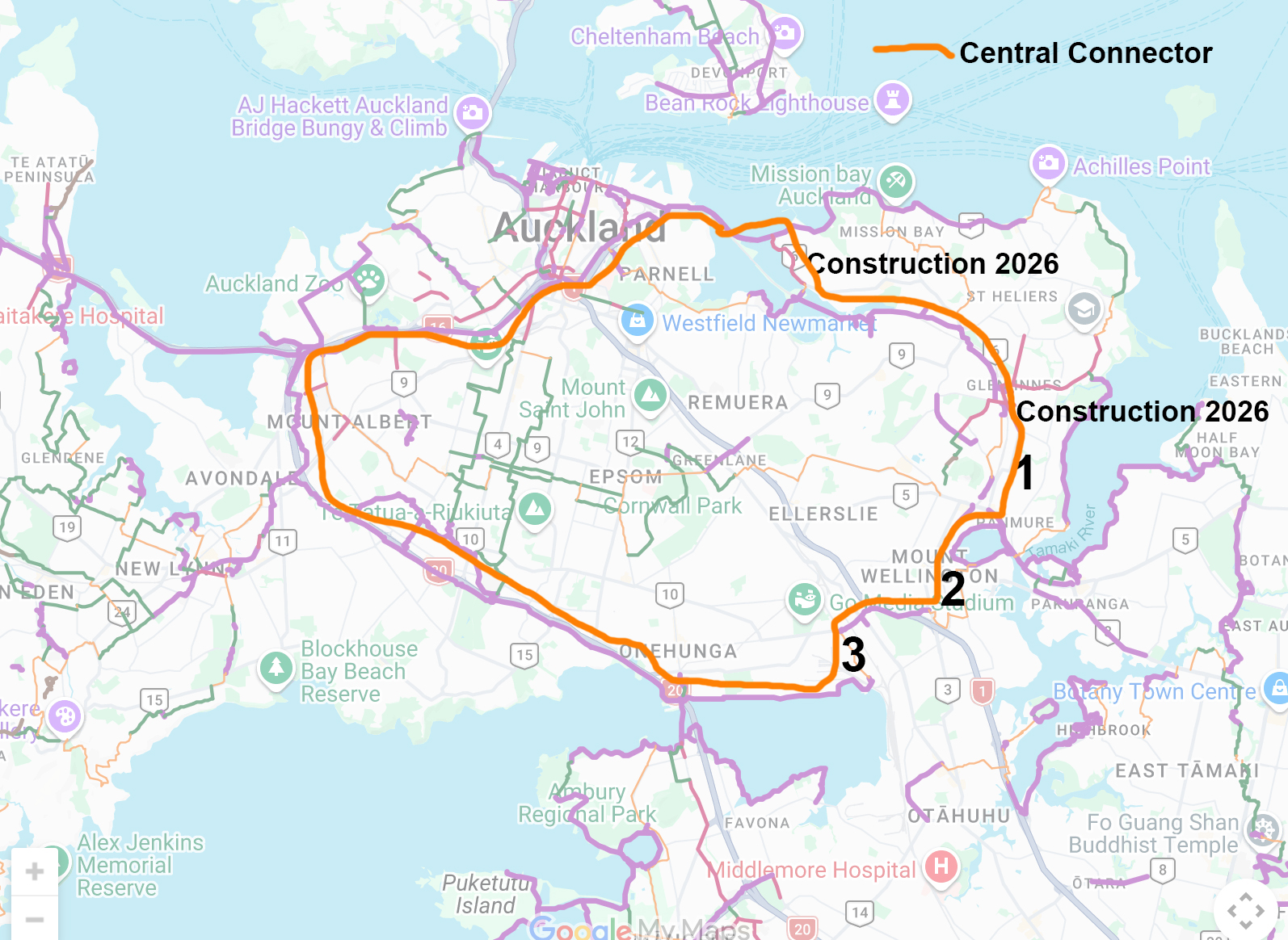
An outline of a potential Isthmus Central Connector Cycleway, via reader Ellen.
Perfect timing
The timing for this vision couldn’t be more perfect, given recent confirmation that the corpse of the always over-scaled and ill-conceived East-West Link will not, in fact, ever be revived – not even by the tarmac-hungry current government. That means Area 3 on Ellen’s map – the most critical safety gap bridging the North Island Main Trunk rail line at Penrose/Westfield – is no longer cursed by the dead hand of a doomed mega-project freezing all local improvements.
“Ungapping the map” (to borrow a phrase from our Vancouver counterparts) would be a fantastic project to get into the upcoming Regional Land Transport Plan for Auckland.
It not only adds further value to the existing infrastructure, it also unleashes key projects that are almost complete – especially the “Desley-Way”, i..e the final leg of the Glen Innes to Tāmaki Drive shared path currently taking shape around Hobson Bay.
Area 1 – Pilkington Road through Panmure
As Ellen points out, the Pilkington Rd/ Panmure town centre stretch is also the missing gap in a continuous cycle connection from the city centre to Pakuranga (and later Botany?). The Glen Innes connections under construction currently stop at the Pilkington/ Apirana/ Tripoli roundabout, leaving a gap if you want to bike safely from there to Panmure.
Fixing this would also help expand the catchments of both Glen Innes and Panmure Stations, and improve transport choice for the communities of Tāmaki, Pt England, and Stonefields.
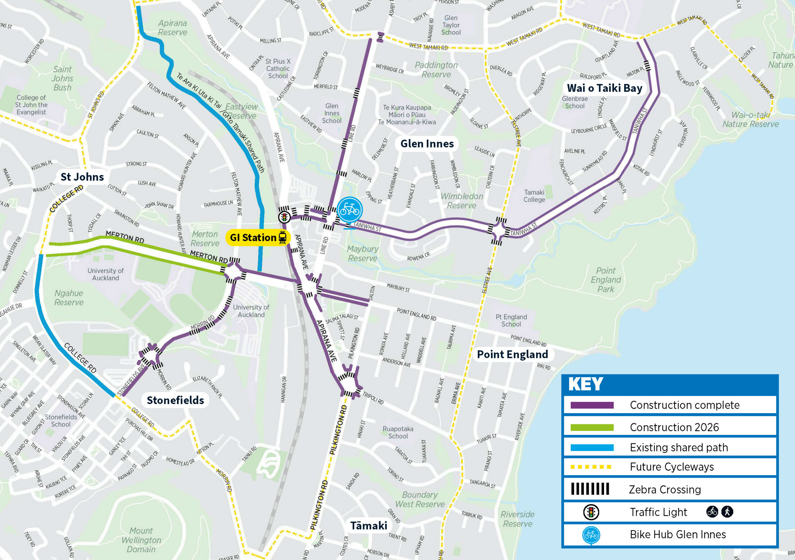
Links to Glen Innes, currently under construction: map via Auckland Transport
Readers with long memories might recall that Pilkington Road was originally identified for funding under the 2014 NZTA Urban Cycleways Programme. Whatever happened to that plan? In any case, a fix is now well overdue.
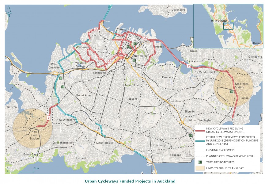
The 2015 Urban Cycleways Programme vision for Auckland, with Pilkington Road (between Tāmaki and Panmure) shown as one of the “new cycleways receiving funding.” Image via NZTA/ Waka Kotahi
Areas 2 and 3 – Mt Wellington/ Sylvia Park, and Southdown/ Penrose/ Te Papapa
This whole area is a ghastly Darién Gap for anyone who’s not inside a vehicle: impassable, impossible, and frighteningly dangerous in parts. Ironically, Auckland Transport recently made some quick low-cost improvements to the giant roads as part of the Auckland Network Optimisation Programme – but unfortunately, nothing for walking and cycling. Once again, those fundamental networks did not get optimised.
Which is why Ellen’s nudge is so timely and powerful. Solving these issues isn’t just of benefit to those who want to go on a long leisurely loop around the isthmus. It’s also – and especially – valuable for opening up local trips, all along the way.
Just a couple of small interventions could unlock so much. Not least of which is better access to Sylvia Park itself. Imagine being able to safely ride or walk to IKEA. As it happens, that’s something IKEA’s own management also values!
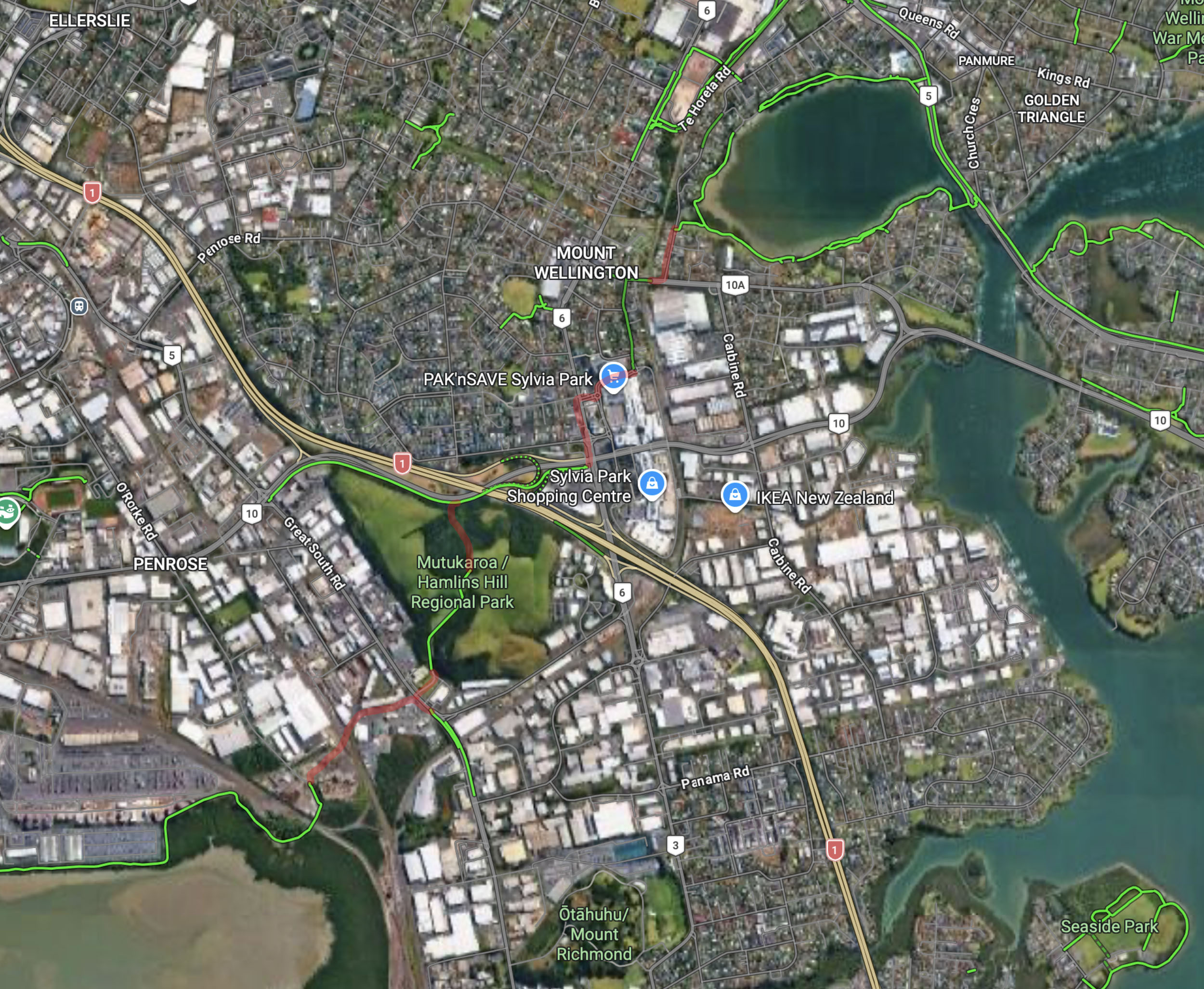
The area around Penrose, with the crucial missing links to Sylvia Park shown in red.
You could also easily improve access to and through Mutukaroa/Hamlins Hill Regional Park, an under-loved local gem.
This area really is a terrible desert for meaningful local access. It’s a striking example of how if we only build for vehicles, we fail for everyone, including drivers. Thankfully, the well used Sylvia Park Station is there for connection to the Rapid Transit Network, so better active mode connections to and through the mall would extend the station’s catchment too.
Local knowledge and political champions
With Council’s transport planning in a state of flux right now, visions like these desperately need political champions. And the best way to find those is by energising local enthusiasm and insight.
I have no idea if the lines I have drawn above and below are the best answers, especially as Google is an unreliable source for existing safe cycling advice. So, this is a wider call for a study on how to best unlock these barriers to access.
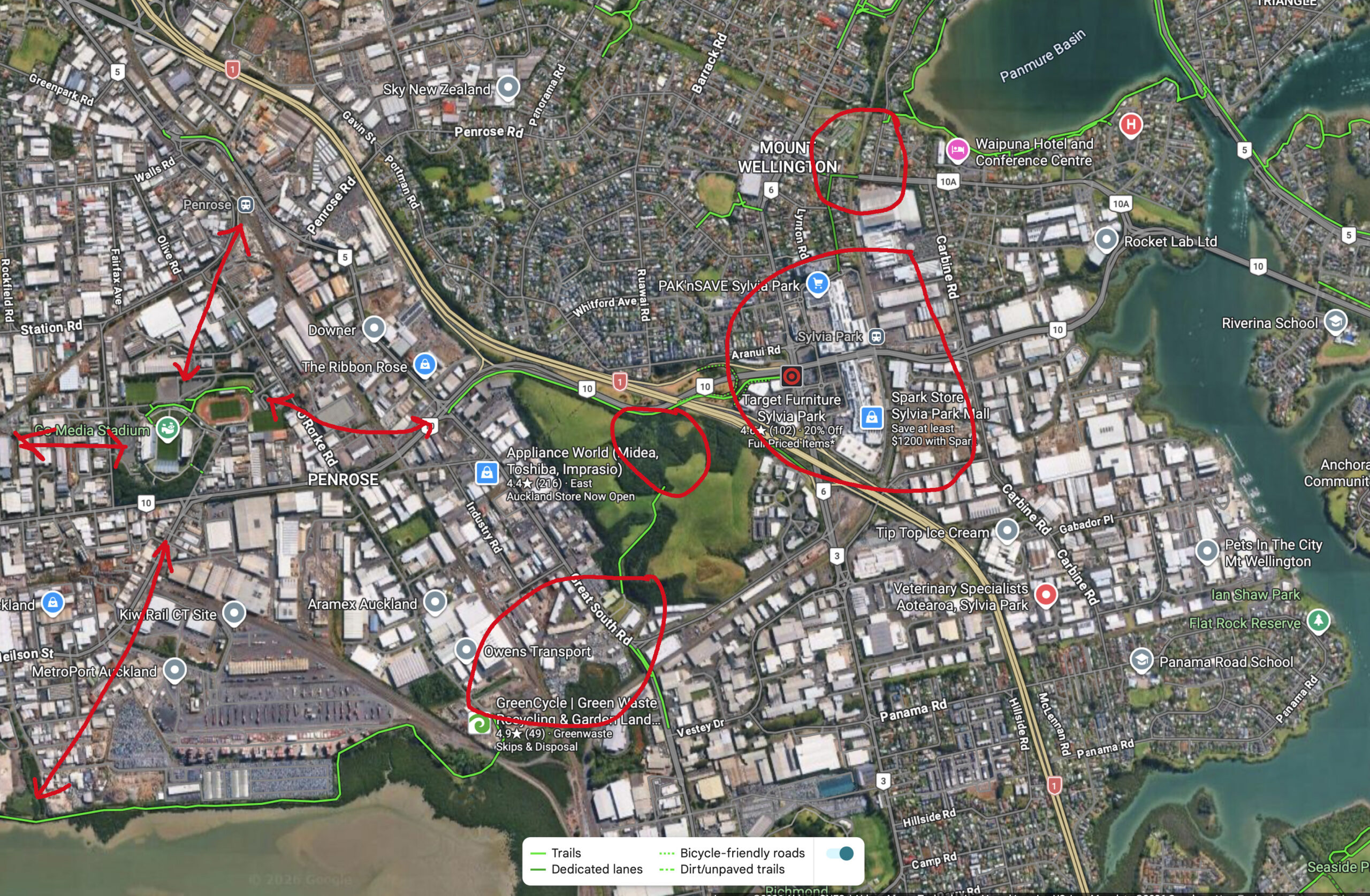
More missing links – including stadium access – in Mt Wellinton/Penrose/ Sylvia Park/ Te Papapa/ Onehunga.
Local experts Bike Onehunga have been discussing the potential here, too. So this is a great opportunity to expand and share the knowledge. Please weigh in! For example:
- How about better local access to Mt Smart/ Go Media stadium? In theory you can cycle there for events – I know people who have – but in practice there are some very forbidding stretches.
- The Hugo Johnston Drive/Church St intersection is due for improvements under the Network Optimisation Programme – what would make it safer for people on bikes and on foot?
- Any updated thoughts on Bike Auckland’s 2013 suggestion for a cycleway link from Waikaraka Park over the railway line to Sylvia Park?
- And what about access to schools, shops and stations?
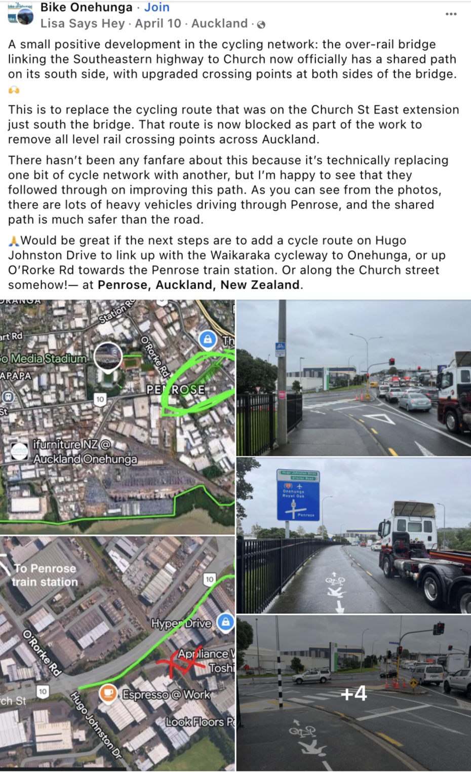
Ultimately, this could be an example and a nudge to all of us to identify other missing links and clever fixes to campaign for – so we can “ungap the map” and expand access in every corner of our city. What an exciting idea 🙂
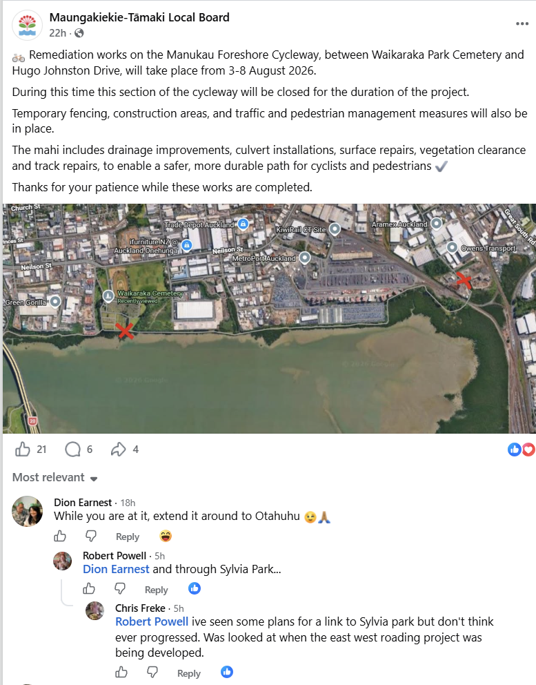
PS This piece of news just washed across my screen. It seems there is a lot of interest in this route; the planets are aligning.
PPS History offers us yet another reason to solve this particular area. It’s home to (the ghost of) Auckland’s first arterial cycleway. In 1935, a kilometre of dedicated bike path was built along Great South Road from Penrose towards Ōtāhuhu…
The [Mount Wellington] Road Board was at present arranging to seal 8ft. on either side of the concrete pavement, of its section of about 50 chains between Penrose and Westfield, with a view to accommodating cyclists. This length was being subsidised by the Main Highways Board.
The work was championed by the Ōtāhuhu Borough Council, after a string of awful fatalities, on behalf of local people biking to work and school. Our great-great-grandparents would surely be glad we’re finally catching up with them.

 Processing...
Given the glacial pace of introd7cing existing bike infrastructure could someone like Greater Auckland become an infrastructure provider under the new planning acts, designate the route to protect it and charge a small fee to use it and support a biking network throughout New Zealand? And gain any consents required as a fast track application to avoid some of the vested interests that may be standing in the way of existing biking proposals?
Brilliant. Just a few short links and it’s done.
Then there is the issue is the cycling black hole within the four corners route.
I think the plan to link up the missing pieces is very well thought out, and should be a priority to finish within 18 months.
In the South Island there are a number of long distance walking/cycling trails.
One in particular links Westport (Kawatiri) to Charleston which is 42 km long, and on a bike with an average rider would take about 4.5 hours. It is possible to access it along the way, so you can be dropped off at one point, and cycle say 10 or 12 km and then be met further down the track.
The same would apply in Auckland if you just wanted a short ride.
All you need is a car bike rack!
Name is: Kawatiri Trail.
The other day, a cycling friend was extolling the virtues of Auckland’s “Outer Four Corners Route”. He and a friend take a ferry to Pine Harbour – 1st Corner
Ride to Takinini – 2nd Corner
Ride to Westgate – 3rd Corner
Ride across the Upper Harbour Bridge and into the North Shore cycling desert to the 4th Corner at Devonport and back on the ferry.
He says they can do it mostly on protected cycleways (except the North Shore) although I can’t remember the exact route details.
If this is the Outer FOur Corners, the route suggested above could be “Auckland’s Inner Four Corners”
This is my favourite Sunday loop ride – and its always gutting when you get spat out into Otahuhu’s industrial wasteland then the start stop cycleways until you hit Glen Innes. I assumed this was always on someones radar.
Yes, Ellen’s, as it turns out.
“a nudge to all of us to identify other missing links and clever fixes to campaign for – so we can “ungap the map”
I want to be really positive and help do this, but my pet gap, is the Upper Harbour Drive/Albany Highway intersection from hell
This death trap is well known; there is a fantastic bit of cycle friendly infrastructure that allows me to do a long ride out Northwest and back around to the Shore, but this intersection dumps cyclists in an uphill climb with a fast moving traffic on the left and the right of an unprotected narrow strip.
I can’t be bothered going back through my posts and email chain, but I am pretty sure I reported it many years ago, followed up around Covid times with AT, and again a few years ago.
Response from AT was; we are looking at it, and have consultants doing a plan.
In short, what more can I do? I can’t design the solution (though have some ideas), I can’t get out and help build it.
Reporting it to AT, local cycle groups, posting on here, and council doesn’t seem to want to do anything
If I sound bitter, I don’t cycle that area anymore, but driving through just a couple of days ago and saw a couple of cyclists taking life into their hands and trying to get through in heavy traffic, is a regular reminder.
On this – AT have 13.3 million from the climate action targeted rate to fix this for cycling.
However, they have decided to now investigate fixing this area for all modes. Costs are up to 84 million and no construction time frame.
I know the local board chair in particular is pushing them to just build the bloody crossing.
You can see the latest presentation on this here: https://aucklandcouncil.resolve.red/portal/meeting/10539/95822?type=2&docId=50036
AT is closing in on the affordable early start on how to cross that road without playing chicken by whittling down from unaffordable long-term options to a just-affordable long-term plan, so the early start fix can be justified. Business cases are soooooo protracted.
Sharing is caring, I for one am sick of more RoNS living rent free in my headspace
Funnily enough, Links to GI project actually started off as a project called Panmure to Point England, sometime around 2012. Pilkington was in that scope, but was not in the final Links scope. But then the Stonefields link was added. Wonder why?
Another option is use the AMETI link stage 2 (continuation of Te Horeta Rd) through to Merton via mostly already acquired green area to the west of railway line.
Tamaki Transformation were actually consulting on a Tamaki loop that included this area but it went quiet.
And yes, would be good to sort out Mt Wellington Highway for bikes, peds, and cars. Probably gotta lose the flush medians which encourage crazy cross lane turning into residential against the traffic flow.
This is marvellous. As explained by a highly entertaining Dutchman last night, engineers are only interested in whether we can outrun poo, so bike path connectivity gives us a chance!
The health benefits of paths that do not allow fossil fueled vehicles near them are incalculable, positively!
With the CRL giving us more opportunity to be people, persons, humans, and not just linguisticly divided machine operators, social cohesion and peaceful coexistence could reenter our civic conversations.
The more money we can steer away from encouraging more fossil fueled suicide, the more we can push towards positive living, breathing, and remembering we are all human, NOT MACHINES.
Te Hau Maangere is our current most beautiful piece of car free infrastructure, the completion of the Tamaki piece of the GI bike path means that there will be more safe routes, for kids especially, and learning the freedom of what a bike provides, is one of the most important things a child can learn.
I still believe that de wheeling is far more important, thought wise, but de wheeling is really just code for detoxifying our existence.
bah humbug
Interesting to look at the language used by AA in that article from 1935. How to make GSR safe for motorists by getting the dangerous bikes out of their way.
And sad how the greedy road then went on to eat the extra width of the cycle lanes.
Cosmic alignment of planets alright. Ill try post more later in the day when on a keyboard – related project/s idea sent local board and such. Was thinking of doing a post on it but I just haven’t quite broken it down into a good size set of posts formatted right . Etc
We’re all ears when you’re ready, Grant!
Might link a “Google Pageless” document as it was so hard to keep formatting on Google Doc with actual pages. Lots of pictures, like my Newmarket one a bit so should put a link but I’ll check it a bit first, some things will be a tad dated like photos/descriptions If I don’t post it soon.
If you want I can eventually make a multi-part post for it, would suit Bike Auckland too.
OK here’s the link, document is pretty big but the bulk of it is made up of images, best viewed full screen if the picture/map is large and want to see more or it or more detail.
Welcome to any suggestions, corrections, alternate ideas on any section or extension ideas. Near the ends are more vague perhaps & I’ve had different thoughts since.
Oh also it has a lot of shared path areas where I feel it’s better to have something than nothing for an initial link that is more cost effective perhaps and can be upgraded as necessary. I started on a detailed lane thing for Mt Wellington Highway but that’s kind of a work in progress.
It was hard to limit the project scope once started, lol I see why they have “out of scope” limits now.
Link below (not sure why top heading left aligned):
https://docs.google.com/document/d/e/2PACX-1vQGygNZzsCT7G292WqYu9mog4C5Y2OMYZycbEc270_zRbWjHLNBMhdHV7wCVifGe9fwkbY3l63E_dy1/pub
Oh the bottom of it has a key, not really a standard key but worked that up for this to work. Can open the document twice in a new window if you are on a PC might help and have the Key in one window.
This is an incredible and rigorous analysis Grant! It is definitely worth a post (most likely in multi-part) that goes through it. Definitely worthy of further discussion/promotion in Greater Auckland and Bike Auckland!
Thanks people for encouragement. Yes think could easily do two parts for the initial main path then three more parts for whatever else.
Looking forward to seeing your post and understanding more!
Agree this would be awesome. But even more awesome would be a route North/South and East/West in the middle of that circle rather than having to ride all the way around! They keep building cycleways where it is easy rather than where it is useful.
Also, is the Hillsborough section of the South West cycleway considered “dedicated/ off-road cycleway”? You ride on the road, and it is very very steep.
My idea is half way across that circle roughly.
This is part of my daily commute. Its all good on the way down, but not on the way home.
If the motorway builders were not only about roads they would have put an underpass in for Hillsborough Road and then could have cut off the top half of the hill. by following the motorway alignment.
Yeah not really happy with Hendry Ave. Even going carefully and slowly, descending in the wet can be sketchy. The new disconnected sections of bike path they put in cause you to have to swerve in and out of parked cars, often with oncoming cars trying to accelerate up the steep bits. I’ve never felt safe going up either and not really sure what putting protection in only for short bits every 20m so that cars can still park really achieves? The old way you could take the lane going down, but now there’s speed bumps between the protectors, and the protectors force cars into one space so you have to go to the left regardless to avoid the oncoming cars.
And just over the fence they did massive earthworks to make it less steep for cars on the Hillsborough Road offramp with miles of safety shoulder there too. Couldn’t they convert all that massive wide space into a protected bike lane/shared path? I ride through at peak hours and there’s never enough traffic to justify a 4 lane offramp from a single exit point off the motorway.
Don’t most people cut just through the office buildings near the end of Hugo Johnston, over the railway line, cross GSR at the lights then continue on the cycle path next to the Southeastern highway? That’s certainly how I ride it, and it’s entirely fine.
Shiney new dedicated cycle path would be great, but it’s not the Darian gap this article suggests. Same with GI to Panmure, both Pilkington and Tripoli are generally very safe roads
I’m a local and Pilkington and Tripoli are really not safe. Weekend Lycra brigade do use Tripoli but very few kids or commuters. Also there about six schools along that road.
Also there are literally hundreds of new houses and units now being built along the road which will lead to on street parking disputes etc.
I’m a commuter from east of the river heading into the city and ride Tripoli to join up with the GI to Tamaki 3 days a week and never encountered an issue with it.
This was blocked at one point a while ago wasn’t it, is it open again now?
OK think looking at Street View and thinking back it was a tidy up and improved pedestrian / safer gate crossing system put in.
Crossed conversation. I was referring to near Hugo Johnston Dr, but glad it matched up.
Correct. Tripoli is still blocked because of installation of water pipes. It has been blocked on and for several years but there’s a traffic detour along Dunkirk at the moment
Hugo Johnston to GSR shared path: provided to allow Church St LX to be closed.
Try the new rute and share any problems with it.
Tamaki Regen is slowly improving parts of the streets between Panmure and Glen Innes. The Pilkington Gap does need closing when a government will allow spending on cycling, but some parallel quieter options might come about sooner.
AMETI shrank from a motorway to a great cycle path. Let’s work for the same with EWL.
Sylvia Park management might think about how they may get improved access to their destination.
Although part of that alternative route was Torino Reserve. Auckland Council is now proposing to dispose that reserve and give it to Tamaki Regen – to build more houses! This park sits between Pilkington and Tripoli.
I’ve ridden this loop a few times and regularly bike commute to Neilson street and have opinions on these sections.
I don’t think cutting through Hamlins Hill is the best route for a bike highway. The green part of your track is a gravel road with many gates, and stock grazing = shit everywhere. You could use some cattle stops like the Totara park Mtb tracks have, but I think Hamlins Hill is better as a destination, rather than the cutting through the middle. I also love the serenity at the regional park and would love to keep it nice and quiet 🙂
A bike lane on Hugo Johnstone would do the job, the path is OK from Church street through to Mt Wellington highway, although it could use a spruce up. Alternatively a new crossing at the end of the Waikaraka path joining to a new path on Sylvia Park road would work well.
The worst part is between Mt Wellington highway and GI. There are a few options here. Once you get to Te Horeta Road the path is not too bad, and then at the other end there is are some quiet roads along Hannigan drive, and a path from the end to GI station. Alternativly it would be good to have a connection along Ireland road and continuing on Pilkington road.
There also used to be a connection from the Waikaraka path through to Miami parade. The landowner decided to bulldoze this oneday.. Restoring this small connection would mean I don’t have to bike along Neilson street.. Long term Neilson should have a two way bike lane all the way from Captain Springs to Church street providing a nice connection to the stadium, and traffic lights added to the Metro Port entrance.
Hey Bold,
I’m riding from Glendowie over to work on Sylvia Park Road. The bits through GI are not too bad – either on a cycleway or roads that are not busy – depends if you’ve got an extra ten minutes to go along the Tamaki River. Cut through the Panmure Lagoon is good then and hook up to Sylvia Park Mall is OK but that last km on Sylvia Park road is a shocker! Narrow road, lots of trucks really not setup for Bikes!
You can get on SE Cycleway however it still spits you out into a heavy traffic area. I’ve always though they could put something in place by Van Dammes Lagoon and the train track for cycling. Neilson Street has a lot of trucks and entranceways and in those cabs cyclists are not so easy to spot. Hopefully we will see a loop soon
Back in 2008-9 as a member of the Auckland Council Transport Committee I introduced the idea of a couple of new cycling routes parallel to Dominion Road and running from South of Mount Albert Road to the inner city. Transport planners got interested as they had a major project to improve transport links through the middle of the isthmus. After considering 4 existing arterials (Sandringham Road, Dominion Road, Mount Eden Road and Manukau Road), and after extensive public consultation, they settled on Dominion Road to be the main traffic throughfare through the isthmus but rather than am 8-lane motorway as planned in the 1960s (shades of de Leuw Cather) the thinking was more “liveable arterial”. There was some serious money dedicated to this project but it took so long to plan such a complex project that it was inherited by the amalgamated “super-city” (Auckland Council) in 2010. Physical work was to start in about 2015, but was overtaken by the proposal for light rail from the central city to the airport via Dominion Road, so the planned road works never happened. However, the idea of creating cycleways parallel to Dominion Road rather than actually on it was implemented as a first (and as it turned out only) step. Most of the cycling routes were along relatively quiet residential back streets rather than busy arterials. Four specially designed intersections were built to allow cycles to safely cross over Balmoral Road and Mount Albert Road without having to detour off their desire line. A new “eel” bridge was built over Oakley Creek. The two cycle routes were completed but for some reason never officially opened – I suspect this was connected to the larger project being parked while the light rail project had supplanted planning for the long promised upgrade of Dominion Road leaving the project team a bit confused and even angered by what they were supposed to do. Although sign posted, the two routes are less than ideal as in places there are deviations away from the more direct routes originally planned. It is quite some time since there has been any discussion of completing this project but they are well used by local school kids getting about their neighbourhoods.
PS – you can see the 2 routes running more or less parallel to Dominion Road on the first map in Patrick’s post. They are marked in green.