Next weekend I’m heading down to the capital for Matariki and to ride Te Ara Tupua. In advance, I’ve been thinking what we can learn from the evolution of this corridor over time.
I was last there in January 2026, when Waka Kotahi kindly gave me a tour of the nearly complete project:
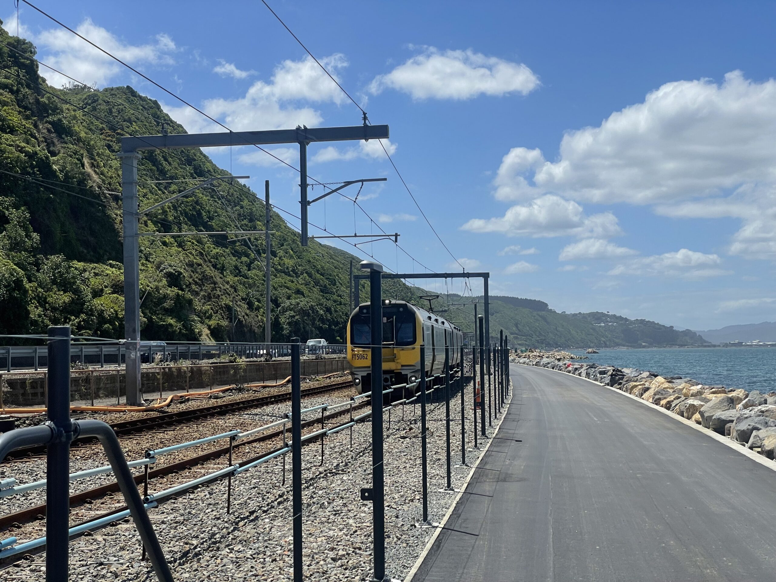
Te Ara Tupua, January 26. Image: Patrick Reynolds
Land Bridge
The best way for Aucklanders to think about this key link between Wellington City, the Hutt Valley and Wairarapa is that it’s their Harbour Bridge. More on that later. First some history.
This transport corridor was gifted to Wellington by the earthquake gods. The Wairarapa earthquake of 1855 lifted up a shelf of rock along the northwestern edge of Wellington Harbour, delivering a brand new land route linking the city and the Hutt Valley, threaded between the sea and cliffs. It connected the region’s rare sections of flat land, and the two new immigrant settlements.
Interestingly, the quake was actually on the Wairarapa fault, which is east of the Wellington fault shown below – but it did uplift sections along the former by up to 6m, at the southern end of the Remutaka range.
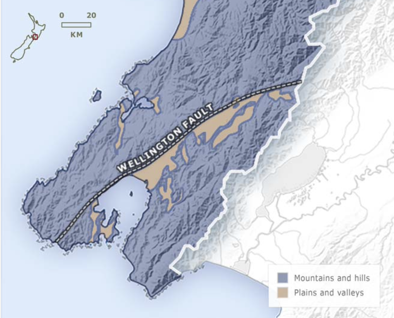
Geography of the Wellington Region. Source: teara.govt.nz
Over time, the shelf was developed from a rough path to the first railway line out of Wellington – the Hutt Valley line (1874) and, interestingly, a toll road. I don’t have a date or a source for the image below, but it is super interesting.
[Ed: per this post, it’s from a book called Views of Wellington, Hutt Valley and the Bays, Whitcombe and Tombs, 1959]
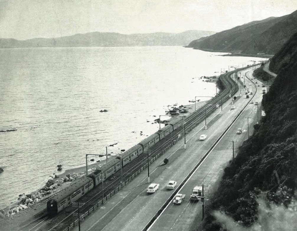
Hutt Valley Line, and Hutt Rd. Date unknown, possibly 1950s.
In the image, we can clearly see the electrified (as of 1953) Hutt Valley railway line, and a wide paved path for walking and biking, which is fenced from the tracks and nicely separated from the four-lane Hutt Rd by a wide strip of grassed berm. A proper all-modes high-capacity transport corridor. With trees, even.
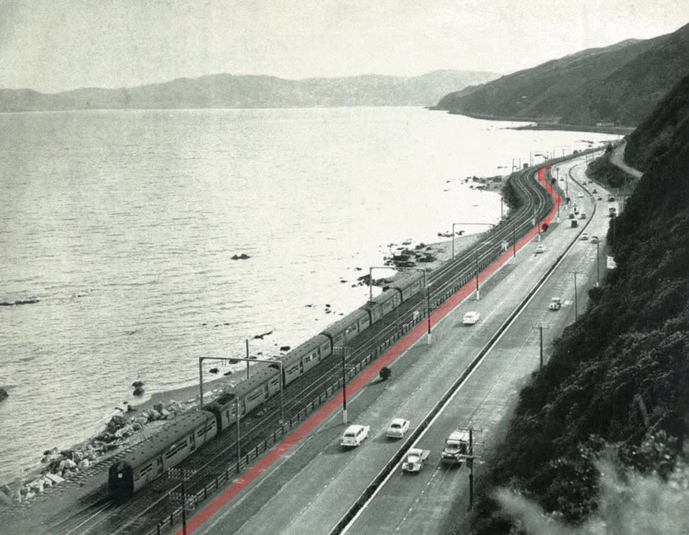
The original active modes path – highlighted in red – between the Hutt Valley Line and Hutt Rd.
The Hutt Valley Rd was incrementally upgraded through the auto-boom years of the post-war era, into becoming the Hutt Expressway. I say upgraded, but in fact it was changed in ways that highlight what an extreme period the second half of the 20th Century was for transport policy, governance and design.
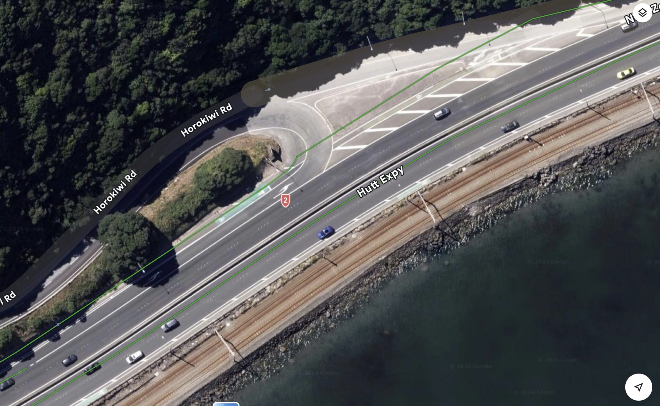
Hutt Expressway, as seen by Google Maps, with the green lines showing cycle “amenity”. (For accuracy, the citybound green line should properly be in the hashed white space on the very edge of the highway, alongside the rail line. But also, look at the way the Hutt-bound riders were asked to cross that Horokiwi on-and-off-ramp!)
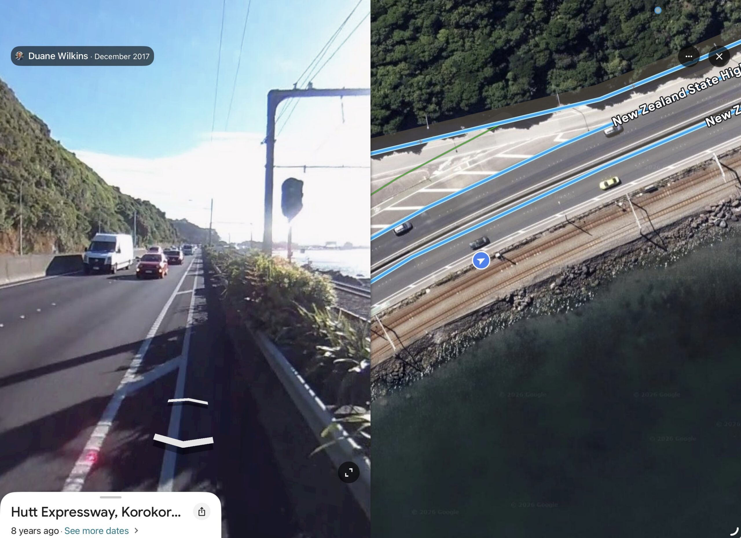
The late 20th C version of the Hutt Expressway and “cycleway” (!).
We can see that the already separated four-lane road was widened by taking out the existing pathway for people, leaving nowhere good for anyone to traverse this route outside of a motor vehicle or train.
This is an example of just how extreme this period was, and how one-eyed those are who still think about land transport in this totally mono-modal way. This is an ideology inherited from the United States – not exactly a land of balanced thinking around transport, like this sorry example that came across my socials recently:
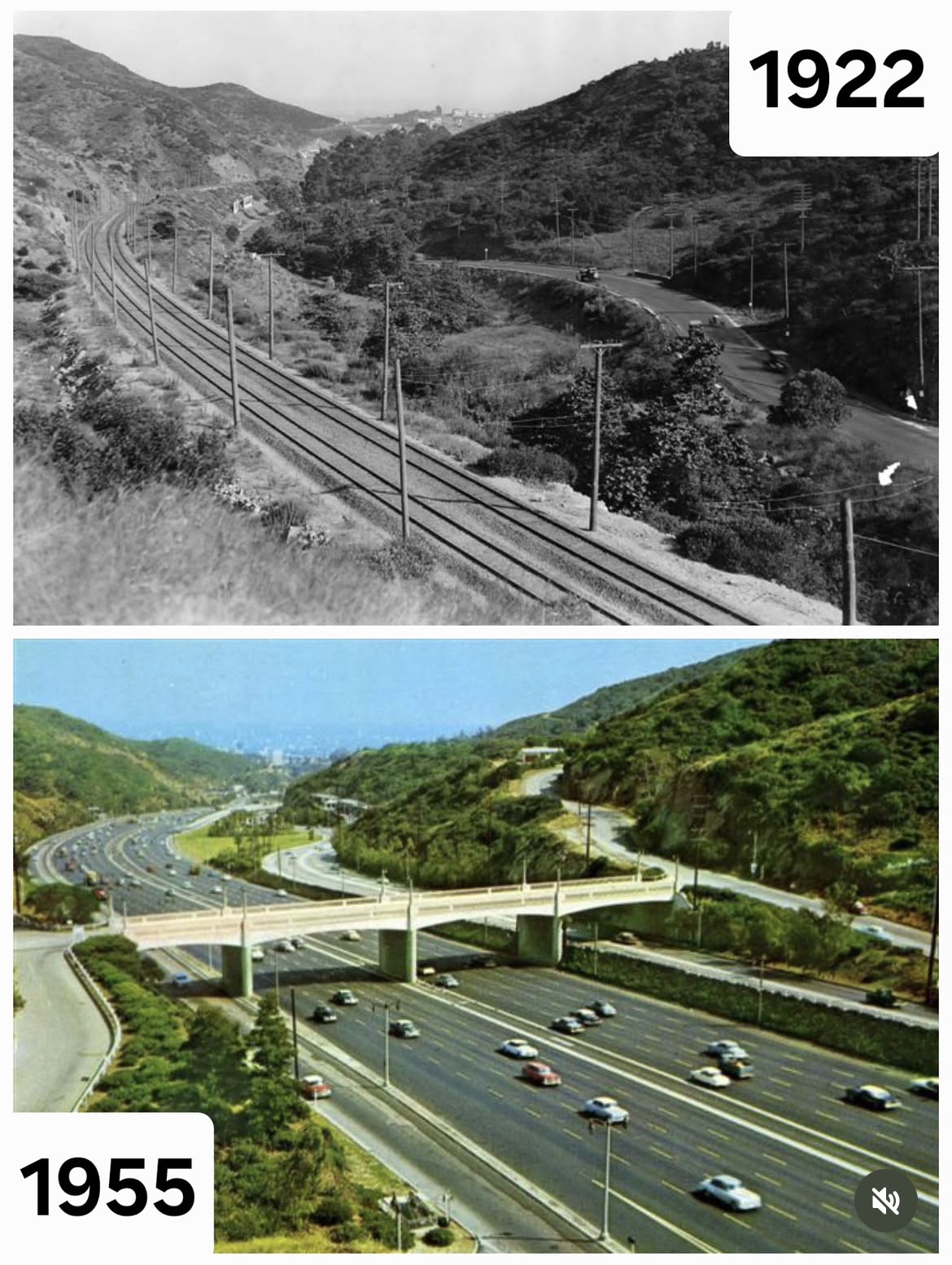
Sepulveda Valley, California: see how it grows, and for whom.
This is the Sepulveda Valley, out of LA – and I guess this shows just how grateful we should be that the Hutt rail line was spared during this period too!
In the coming decades, the LA Metro Board is at last to add (return) a rail line to the Sepulveda corridor. It will be tunnelled, at great expense, as the Interstate 405 highway is now so wide it occupies the entire valley. For further context, the I-405 is the busiest highway corridor in the United States, serving 379,000 vehicles per day. It has been constantly and expensively widened, flooding the cities on either side with endless traffic and of course, further heating up these fire-prone hills. The I-405 is also famously congested.
We cannot be smug about this, however, as we have so many examples of the same short-sightedness here, having learned so dutifully from our American masters.
For example, SH16 in Auckland was widened just last decade, resulting in higher traffic throughput, but no less congestion, just like the I-405. This work, carried out under the direction of transport ministers Joyce and Brownlee, not only did not add a parallel rapid transit line, it did not even leave space for one to be added in the future – despite the obvious success of the near identical example on SH1 on the North Shore.
So now, we are planning to retrofit a much needed rapid service along the SH16 corridor, but at much greater expense, and way later than needed. And also too late to better shape the land-use along its route.
Present Imperative
How did this extreme mono-modality become normalised? A key feature of the second half of last century was the massive spread of private vehicle use, through new and lower cost mass motorisation across the western world.
Road and street networks were not ready for this, so there was a real urgency to expand driving and parking amenity. This driving growth period continued into the early years of this century, when, essentially our road networks caught up.
Perhaps unsurprisingly, the structures and processes set up during the motorway-fever era – and that funnelled so much investment into roading – continue to be held onto by many in the sector.
Its primary vector of transmission is via a method, probably still taught to baby engineers and transport planners, called “predict and provide”: predict endless traffic growth to justify providing endless road expansion.
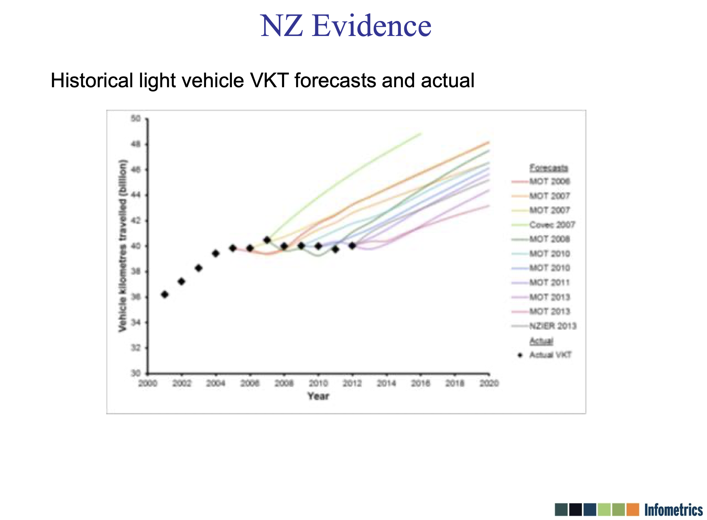
An array of over-confident early 21st C forecasts vs reality. The colourful lines show official expectations (primarily from the Ministry of Transport) of how much New Zealanders would drive in coming years, vs. the actual amount of driving, shown by the black diamonds. Major decisions and huge investments were made – and are still being made! – on the basis of those wildly speculative, and demonstrably very wrong, upwards-trending lines. (Source)
Present-proofing
The era of massive private vehicle growth was a particular moment and is no longer the case. We have other imperatives now. The current urgency for our cities and transport corridors is the need to be more resilient to the impacts of the changing climate. And of course, land transport – largely in the form of personal driving – is also our second biggest contributor making the climate even more volatile.
So, while rugged-ising our transport networks, we also need to accelerate our transition to less brutally polluting systems. To fulfil both of these imperatives, people need real choices in the ways we’re able to access all we need.
There are still, of course, many good cases for investment in roads and streets. It is just that the urgent un-served vehicle growth case of the previous era is gone for good – and so should the policy and practices that framework gave birth to. Our transport needs are way more nuanced now.
The vulnerability of Wellington’s Hutt Valley rail line in the pictures above was finally found out in 2013, when a storm broke the seawall, cutting all rail services. Though it should be noted the rail line did still do its other job, of protecting the expressway from being washed out.
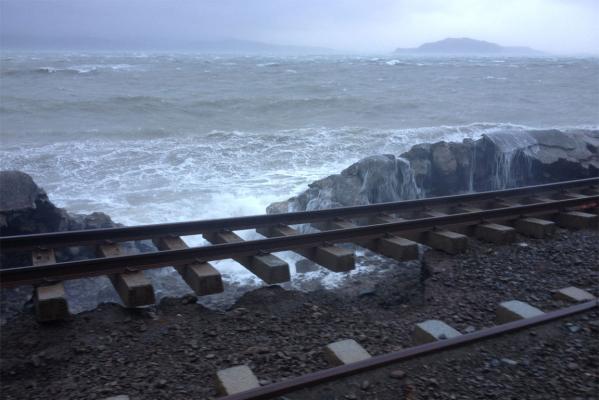
2013 storm Hutt Valley Line. Photo credit: David Morgan
Te Ara Tupua, the new walking and cycling path, has now transformed this route into a model corridor for our times: one that delivers protection and choice. Resilient, adaptable, multi-modal. Efficient and effective. Present-proofing.
Exactly what is needed across Auckland’s Harbour, too.
Resources on Te Ara Tupua
Waka Kotahi description of the environmental and construction process:
A traveller’s report:

 Processing...
Thanks Patrick.
Te Ara Tapua is stunning, I walked it on a stunningly blue windless sunday a few weeks back with all of Wellington. Wellington can turn on a stunner. Your 1953 pic with electric trains, 4 lanes of cars/trucks and a walking cycle lane shows we’ve finally made it back to the future 73 years ago – at some expense.
A couple of observations of my Te Ara Tapua experience. Its a thing that makes it really easy to plan a trip to Wellington for. I tried to pick the demographic of people we shared the trail with – couldnt. It was congested, but we managed. No one was grumpy. Some went slow, some people were wider than the path, some dogs ran perpendicular with their leads as carbon framed superbikers flew past at velocity (velocipede?)
No rental scooters ! – or at least very few. The flamingo eScooter i rented flamed out as i neared the water after riding along the highway at a fair clip. None coming from the Petone end either, guessing thats a policy decision and a good one.
Its early days of getting the path between Petone and Wellington back up and running, cafe’s were overflowing, bikes sprawled everywhere. Lots of happy people spending money and being sociable. So many new business opportunities yet to be established.
The path needs widening.
We walked back to where the scooter was parked, it now had a friend – someone elses gps lockout forcing mode-shift. A giant bus pulled up along side and with only a credit card (no motu move) got a smooth top story ride back to central wellington.
Congrats team wellington for delivering this stunning footpath. What a brilliant way to showcase your amazing natural setting.
Auckland – tell me we’re not going underground – Sort out the footpath on the bridge !
The descriptors along the track are very good- details of the wildlife and the history incl pre European. Good mixture of users- this was mid-morning on a Monday… also some cyclists moving at a fair pace.
Does anyone at any level of government actually use VKT for anything? I have come across plenty of engineers and planners who think it is a BS idea to find two things that comove, then multiply them together, and use the multiple as some sort of target.
You know what they hate even more: VKT per capita, cos is plunging in Auckland. Very very unhelpful for fleecing us to build empty new highways out in the country-side at vast expense and to no ones benefit except the financiers and builders (and their KCs).
the TERP planning pushed hard on VKT as does Vision Zero and to a lesser extent Road to Zero. (Vision zero but with non-zero targets)
All concepts actively ignored, though there is a TERP report due end of month from Auckland Council post Phil the CE’s apology for forgetting about TERP too much, and how they can implement of the TERP directives that are affordable.
The electric bus part has saved Aucklands bacon. What else…
The path only protects a section of the railway line, some of the line is still exposed to the shoreline and erosion and washout.
Because it was a cycle project, not a funded rail resilience project?
Well, they can spent the next decade’s “cycling budget” on fixing that.
By my rough measuring online, the path is on the seaward side of the corridor for ~3.6km, rail about 1.6km and the highway also around 1.6km.
The path also covers the most exposed middle section, the Highway the more sheltered city end.
Looking forward to riding this when next in Wellington.
With regards to SH16 though and ” under transport ministers Joyce and Brownlee, not only did not add a parallel rapid transit line, it did not even leave space for one to be added in the future.” I do think it has left space for rapid transit – we just need someone with the fortitude to repurpose lanes- this would save a heap in money, carbon and effort and avoid a heap of distruction along the way.
I wanted to know how long it would take to walk from the Beehive to Petone train station, so I could walk along and experience Te Ara Tupua and then train back to Wellington.
So I entered the route into Google, and I was really surprised to see that Google does not know about walking between Wellington and the Hut Valley and wanted me to catch a ferry across to the other side of the harbour and walk back up to Hut Valley.
That is not very helpful.
Does anyone know the distance from the Parliament buildings to the Petone train station?
As the track is very close to roads, just check the distance by car. It is 10.6km, so depending on your pace, you should make it in under 3 hours.
Google tends to take a while to get these things sorted, but Openstreetmap-based maps are generally pretty quick to add new paths.
Komoot (one such mapping app) estimates 3h35m over 11.7km/h, though you can use other apps that will likely yield similar results.
11.7km, not km/h… duh
“Does anyone know the distance from the Parliament buildings to the Petone train station?”
Yes. It’s 10.8 km from Petone Station to Wellington Station so a similar distance to the Beehive.
I took a train to Petone and walked back two weeks ago. The path only runs between Petone and Ngauranga which is halfway.
Between Ngauranga and Wellington the route veers away from the harbour and follows Hutt Road and Thorndon Quay. This part is not so pleasant.
It takes two to three hours depending on how fast you walk.
Very helpful – thanks!
If you want to walk the new path only, you can train from Wellington to Ngauranga Station. The path from there to Petone is about 5kms.
The motoring industry will use VKT estimates to set their sales budgets.
They must look at those “official” figures and dispare the growing disparity between the sales that could have been achieved if the more favourable to it’s industry, government transport settings, had been maintained.
Better public transport and cycling provision most definitely comes at a considerable cost to these related industries. Well resourced political activism from this source to defend their market is thus a natural consequence. Thus the importance of forums such as this, to provide counter balance.
The Hutt Road corridor is probably NZ’s best example of how a dedicated public transport corridor is spacially far more efficient then just adding more road lanes.
Not only in the corridor itself, but also in the urban areas at both ends.
In the absence of those train services, Just think how providing daytime storage for the required commuter cars would dilute the current interconnectivity of commerce, entertainment and governance in Wellington.
This project is a good example of infrastructure being underspecified, even when the final result is highly successful.
On busy days, there is not enough space to comfortably accommodate all the cyclists and walkers using the path. People generally behave responsibly, but walkers are squeezed into a very narrow walking zone and some faster cyclists still choose to use the state highway because the shared path is too slow. That said, the numbers have settled down since opening (and winter), it’ll be interesting to see how it performs in the busier summer months.
I understand the path was initially specified at around 2 metres wide, before being revised to 5 metres. Even at 5 metres, demand is already showing the need for more generous active transport infrastructure.
The project has been transformative for how Wellington and Lower Hutt connect. The two cities now feel much more accessible and integrated, which feels timely given the current amalgamation discussions.
5m is the minimum for a shared path, we should do better on key routes like this.
I paced the path out at 4.5M (i have a reliable pace…)
Looks like their is room for another 0.5 – 1m of path if needed easily, after that it gets into nippon clippon type expenses.
The path was very full but it was a perfect day, and early into its launch.
Even a walking/cycling path needs fast and slow lanes for safety and capacity. Doubling Auckland’s NW cycleway is seen to be needed as well.
So much this. The NW is way too narrow. We urgently need to fix the worst pinch points, as was done under Bond St.
Especially the terrible blind corner dip by the golf course.
That golf course will still bedevil our children’s children, I fear. They are like the last stand defense lines of suburbia, golf courses.
So happy Te Ara Tapua happened!
Really interesting that there was a walking/cycle path originally; I remember years ago visiting friends in Lower Hutt with my bike, wanting to cycle into town. Picked my way onto the ‘official’ path, which turned out to be square meter tiles without much grouting, so bumpity bump bump I went.
I noticed cyclists on the freeway, so next day I followed someone onto the freeway – what a revelation! Smooth tarmac and fast speed. Still, the traffic was a bit un-nerving. But the new path will definitely be an upgrade.
This is such a boon for Wellington. Yes it was tedious (any development there is) – and seemingly expensive (nothing compared to roading) – but will be such a great thing.
For health, for transport, for visitors and locals… I just hope it continues and becomes an attraction in itself. And the predictable naysayers there relent a bit (every cyclist from the Lower Hutt represents a car off the road, or a free seat on the train) – and ease up a bit.
Yes, seems great, must try it when down there next.
Te Ara Tupua is beautiful and a great piece of infrastructure. I just wish they didn’t take all the cycling budget to essentially build a motorway and railway-protecting seawall with a path placed on top of it.