This is a guest post by Darren Davis. It originally appeared on his excellent blog, Adventures in Transitland, which we encourage you to check out. It is shared by kind permission.
Introduction
Tāhuna/ Queenstown is a year round visitor destination in Aotearoa’s lower South Island, known for its winter skiing and year-round adventure tourism activities. The town of Queenstown has 29,000 inhabitants in the town and 53,800 people in the wider Queenstown-Lakes District, which includes Wānaka, as at the 2023 Census. But this number is overwhelmed by the 4,575,400 visitor nights in Queenstown-Lakes District during the year to September 2025.
Readers familiar with the blog will already know my thoughts about the Queenstown gondola proposal in my Gondola Fever Strikes Queenstown post back in June, including my thoughts on where gondolas works and don’t work.
Since that post was written, things have moved on and the gondola proposal appears to be gaining traction and momentum.
So, what’s the problem?
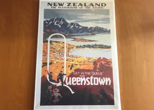
Putting it simply, getting in the Queue for Queenstown in the old school travel poster below meant literally sitting in the Q looking over a small remote settlement of a few thousand people. Nowadays, the meaning is much more literal as Queenstown’s insatiable desirability as a year round visitor destination, fed by air and road access improvements, has led to significant year-round congestion in the town.
The town has a good bus system, focused on a core route – route 1 – between Sunshine Bay and Remarkables Park via Queenstown Town Centre and Queenstown Airport. This route runs from 6am to 12.30am every day of the year and is frequent between 6am and 8pm every day. Routes 2-5 service Arrowtown, Shotover Country, Lake Hayes Estate, Jacks Point, Kelvin Heights and Quail Rise at lower frequency while route 6 is a ferry between Queenstown Town Centre and Kawarau Falls on the Kelvin Peninsula.
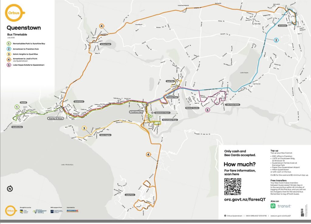
Queenstown Bus Network Map. Source: Otago Regional Council website
Bus anyone who has ridden a bus along State Highway 6A from Queenstown to Frankton knows that these buses get stuck in a lot of traffic, can be pretty unreliable as well as being frustratingly slow.
In spite of this, the current bus system performs remarkably well in Queenstown. In the 2024/2025 financial year to 30 June 2025, there were 1,966,086 trips on the Queenstown bus network, which isn’t bad for an urban population of 29,000, noting that visitors can outnumber residents and make a significant contribution to public transport use in Queenstown.
Current investment
The current investment in upgrading the BP Roundabout at the intersection of State Highway 6A and State Highway 6 in Frankton (and the upgrade of the adjacent Frankton bus hub) will make some difference in the short term when complete. But, of course, the insatiable desirability of Queenstown, combined with current fly and drive dominated travel patterns, means that the BP Roundabout improvements will be quickly overwhelmed by the increase in car travel that it likely induces. This will be further exacerbated by high population growth on approaches to the BP Roundabout from the east in Ladies Mile and even more from the south from growth in Jacks Point, Coneburn and Hanleys Farm.
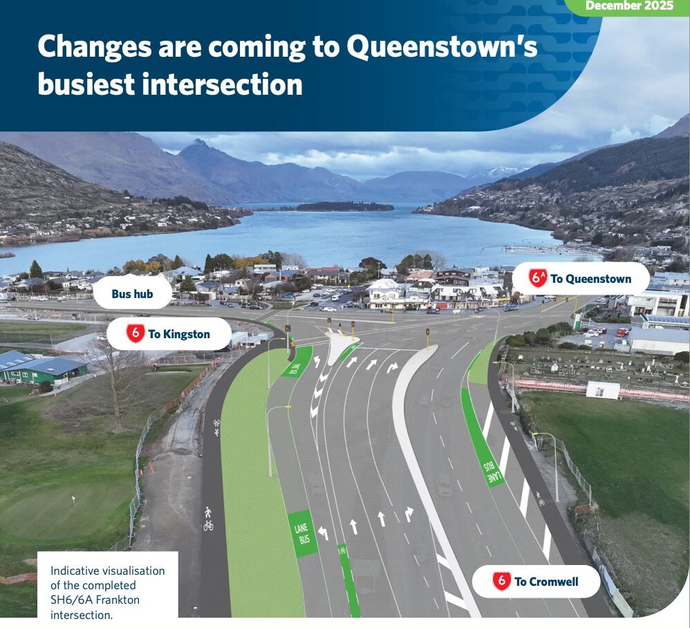
BP Roundabout upgrade. Image source: Waka Kotahi NZTA website
One of the challenges of growth is that distance is a key driver of mode choice in Queenstown. The graphic below shows this clear – as the areas closest to Queenstown Town Centre – Queenstown Hill and Queenstown Bay – have the highest non-car mode share for journey to work. Frankton is around 8 kilometres from Queenstown Town Centre and Kelvin Grove, Lake Hayes and Jacks Point are all over 10 kilometres by road from Queenstown Town Centre.
In summary, the changes are twofold:
- Current transport investments in Queenstown won’t make a significant change to current travel patterns and may in fact reinforce car-centric mobility.
- Growth is accelerating in communities more distant from Queenstown town centre and most of the car trips generated needs to pass through the BP intersection to get to its final destination.
Growth, more than ever
Just before Christmas 2025, a draft decision from a fast-track expert panel was issued for a major housing development at Homestead Bay by Jacks Point on the southern approach to Queenstown.
The development would initially enable 1,438 standalone residential lots, alongside 22 medium-density superlots and 14 high-density superlots across a 205-hectare site at the southern end of the Queenstown urban area.
If fully built out, the site could eventually accommodate around 2,500 to 2,800 homes, though the higher-density and commercial areas would require further consents.
This is just one of many growth areas to the south and east of Queenstown, from where any road-based trip will need to pass through the BP Roundabout.
There is an inverse correlation between distance from Queenstown Town Centre and sustainable mode share, as shown in the chart below, derived from Commuter Waka.
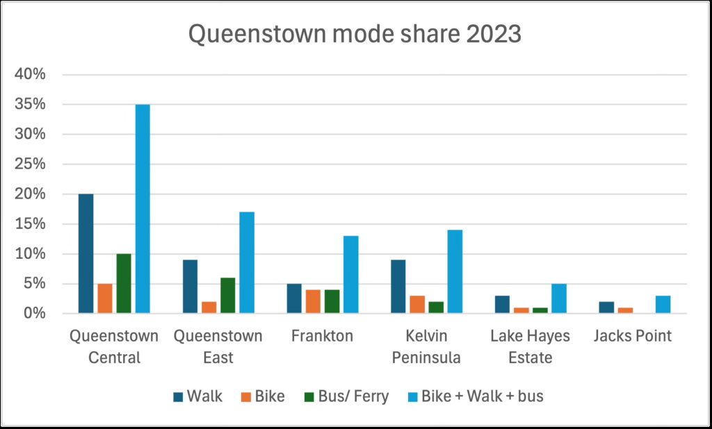
Data from 2023 Census commuter datasets, with travel mode information from Aotearoa Data Explorer.
Distances from the town centre increase from left to right in the chart while sustainable mode share decreases.
This chart starkly outlines that for public transport to work for Queenstown, it needs to achieve significant mode shift for the longest journeys on the network such as those from Lake Hayes Estate and Jacks Point. This is where non-car mode share is lowest and distances are longest, meaning that private vehicle travel contributes to network congestion over a longer distance.
The choice for Queenstown
If Queenstown doesn’t want to choke (even more than it’s already doing) in its own congestion, then it has two fundamental choices:
1. Prioritise buses
This would involve providing extensive bus lanes on the eastern and southern approaches to the BP Roundabout. Between the BP Roundabout and Queenstown Town Centre, State Highway 6 is very constrained between Lake Wakatipu on one side and steep hills on the other. So the choices here are likely to be about providing bus priority on the approaches to significant intersections, which would need to be signalised, and priority through those intersections to get buses ahead of the traffic queues.
2. Avoid traffic entirely
This is where the gondola proposal comes in as it avoids the tricky, and possibly contentious, need to prioritise public transport over private vehicle access on the approaches to Queenstown.
If there is no political commitment and money to do option 1, then option 2 by default becomes the best choice.
So what is the gondola option for Queenstown?
Now known as the Queenstown Cable Car, it is planned to be a cable car network linking central Queenstown with a number of key catchments including Frankton, Queenstown Airport, and Ladies Mile. It is made up of two primary lines:
- Airport – Town Centre Line, connecting Queenstown Town Centre with Queenstown Airport via Queenstown Hill, Lake Johnson, and Frankton Hub
- Frankton–Ladies Mile Line, extending eastwards from Frankton to the Ladies Mile urban area via two potential route options and connecting to line 1 at Frankton Hub
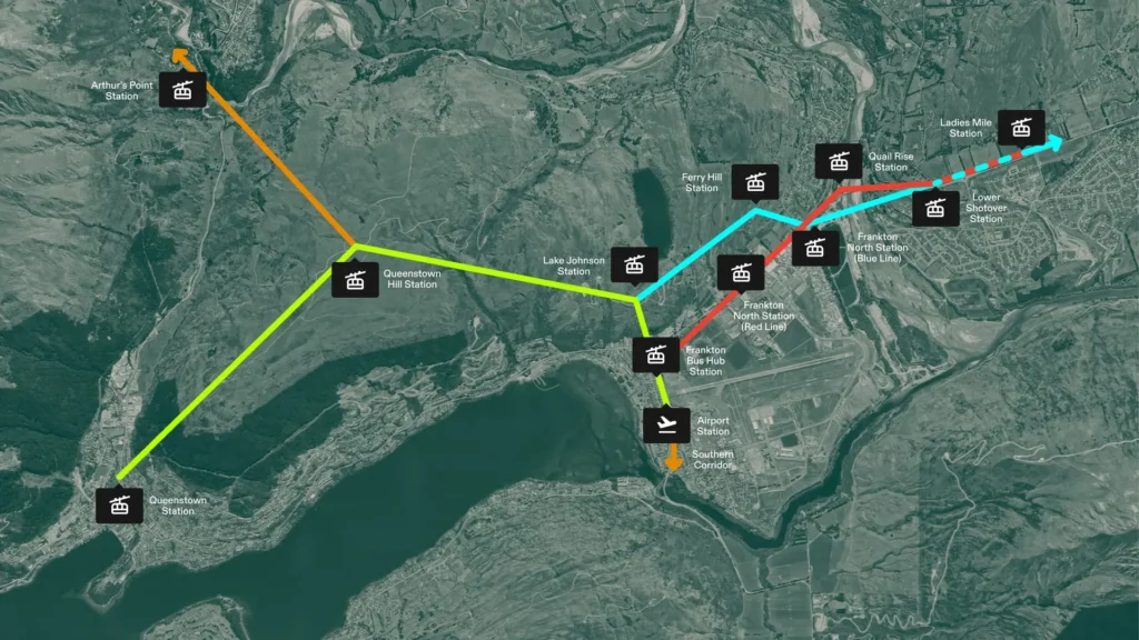
Proposed Queenstown Cable Car Network. Image source: Project website
According to the project website, the features of the cable car network are:
- Around 20 minutes from the airport to the town centre
- Carries up to 3,000 people per hour each way
- Cabins depart every 12 seconds
- Spacious, 10 passenger cabins for comfortable travel
- Fully electric and zero emissions
- Consistent travel times, reliable in all weather
The Queenstown Cable Car project is advancing through the Fast Track process and was referred by then acting Minister of Infrastructure Shane Jones on 2nd April 2026.
Fast Track for Dummies
Here is the Coles Notes version of the New Zealand Fast Track process:
- Any person can apply to have a project of regional or national significance considered for Fast-track approval.
- Depending onthe project, it may need one or more other approvals as part of the Fast-track process in addition to a resource consent.
- The project needs to notify or consult with various organisations before applying for referral, including relevant local authorities; the relevant administering agencies; any relevant iwi authorities, hapū, and Treaty settlement entities.
- The Ministry for the Environment assesses referral applications and provides advice to the Minister for Infrastructure to inform decisions on referral applications.
- The Minister for Infrastructure decides whether the project should be referred to the substantive stage of the Fast-track process.
- If a project is referred, a substantive application for resource consents and other approvals must be made within 2 years of the referral.
The Fast Track website has more detail about this process.
What happens now
Referral to Fast Track is the end of the beginning of the process, but there is quite a bit of process to follow before a substantive application can be submitted. One of the benefits of the Fast Track process is the ability to act as a one stop shop for approvals. But the flip side of this means that all necessary pre-requisite approvals need to be in place before the substantive application can be lodged. And there are quite a number of these.
So what are the next steps in the process?
Actually quite a few steps in addtion to resource consents under the Resource Management Act 1991.
Treaty settlements and other Iwi obligations
Relevant Māori groups identified were Te Rūnanga o Ngāi Tahu, Te Rūnanga o Moeraki, Kāti Huirapa Rūnaka ki Puketeraki, Te Rūnanga o Ōtākou, Hokonui Rūnanga, Waihōpai Rūnaka, Te Rūnanga o Awarua, Te Rūnanga o Ōraka-Aparima, Aukaha, and Te Ao Marama Incorporated.
The Ngāi Tahu Claims Settlement Act 1998 is the relevant Treaty settlement for the project area but no other obligations such as Mana Whakahono ā Rohe or joint management agreements were identified. While the Ngāi Tahu settlement provides for a statutory acknowledgement over Whakatipu-wai-māori/Lake Wakatipu, the project area is set back from the lake and the information provided by the applicant suggests it is unlikely to be directly affected. Several other he Ngāi Tahu Claims Settlement Act 1998 provisions – including a deed of recognition, right of first refusal, taonga species, a nohoanga entitlement, and a conservation protocol – do not appear to be impacted by the application as it currently stands, but nonetheless underline the traditional connection of Ngāi Tahu with this area and its environment.
Some of the reserve land within the project area is subject to a notice under Part 9 of the Ngāi Tahu Claims Settlement Act 1998, which is relevant to some of the concessions required under the Reserves Act 1977. The applicant intends to seek a lease over any land subject to this notice for a term (including renewals) of less than 50 years. However, should a lease exceeding 50 years be proposed, the applicant has stated any necessary supporting information would be provided as part of the substantive application, including written approval for the project from the relevant iwi authority.
Department of Conservation Te Papa Atawhai
The project will directly affect several areas of public conservation land, including marginal strips, and local purposes reserves and recreation reserves vested in and/or administered by Queenstown Lakes District Council
There are existing arrangements and active concessions for the public conservation land, including right of way access for gravel extraction, right to convey sewage, wildlife authorities for trapping pests, collection permits for lichen, and construction of monitoring wells.
Health New Zealand Te Whatu Ora
The report identifies a Government Purpose (Hospital) Reserve owned by Te Whatu Ora/ Health New Zealand with an unclear reserve status. The Department of Conservation recommends that this matter be clarified through a land status check. We note this parcel of land has been excluded from the project area for the purpose of the referral application. This is significant as this is the identified site for the Queenstown Airport cable car station.
Heritage New Zealand Pouhere Taonga
Heritage New Zealand Pouhere Taonga has advised that the project has the potential to modify or destroy a recorded archaeological site and may encounter additional archaeological material therefore an Archaeological authority under the Heritage New Zealand Pouhere Taonga Act 2014 will be required.
New Zealand Transport Agency Waka Kotahi
New Zealand Transport Agency/ Waka Kotahi considers that the project could deliver significant benefits and align with strategic transport documents, but only if it is well integrated with adjoining land use and the existing and planned transport system – particularly public transport – and adopts an aligned fare structure for all public transport users, including cable car users.
Queenstown Airport
Queenstown Airport, as the operator of a controlled aerodrome has statutory obligations under the Civil Aviation Act 2023, Civil Aviation Rules, and its own certification requirements.
Elements of the proposed infrastructure – such as pylons, cables, and construction activities – may penetrate the airport’s protected airspace, including multiple Obstacle Limitation Surfaces. A full aeronautical study will need to be undertaken by the applicant, including detailed design work, obstacle assessments, airspace and operational modelling, and safety case development. Construction activities may temporarily affect navigable airspace which will require coordination and compliance with Civil Aviation Rules Part 77.
Transpower
The project is located near Transpower’s Cromwell-Frankton 110 kV transmission line, the sole electricity supply route to Queenstown and the wider Wakatipu area. Transpower notes that the proposed Route B cable car route would cross beneath the transmission line over the Frankton-Ladies Mile Highway.
Transpower considers that protection of this line, and potential alterations, will need to be assessed as part of the project. It highlights two key matters: mandatory compliance with New Zealand Electrical Code of Practice 34 separation distances during both construction and operation, and the need to determine the technical feasibility and safety of the cable car crossing. Transpower will need to review any electrical clearance assessments. Transpower notes that modifications to the existing transmission line – such as raising or adding structures – may be required to achieve safe clearances. Transpower expects these matters to be addressed through the substantive application, potentially including a condition precedent requiring feasibility to be confirmed before construction.
Obviously, this only impacts this particular route option and if the other option is chosen, then the issue is avoided.
Other approvals required
Civil Aviation Authority of New Zealand – as the project area is adjacent to Queenstown Airport and the Civil Aviation Authority is the responsible agency for managing the safety of navigable airspace around airfields
Land Information New Zealand Toitū te Whenua – as the applicant identifies that a separate approval (occupation consents) will be required from Land Information New Zealand outside the fast-track approvals process
Aurora Energy, Eon Fibre and Chorus – as infrastructure companies that hold existing legal interests (easements and caveats) over sites within the project area
The information in the sections above is synopsised from the Queenstown Cable Car stage 2 briefing to the Acting Minister of Infrastructure on 31 March 2026.
Final thoughts
A lot of water has passed under the bridge but there is lot more water to flow to even get to a substantive application for the Queenstown Cable Car. But it’s clear that a lot of work is being done to facilitate the necessary consents and approvals.
While I still believe that there is a bus solution for Queenstown, there doesn’t seem to be the political will nor the money to make this happen. I’ve always believed in my professional career as a public transport planner that our job is to work with what is there or likely to be there. So, assuming that the Queenstown Cable Car gets across the line – noting that funding, operating model, governance and integration with the rest of the public transport system remain open – then it’s incumbent on transport planning professionals to help make it the best project that it can possibly be.
Greater Auckland’s work is made possible by generous donations from our readers and fans. Support our work by joining our circle of supporters here and setting up a reoccurring donation.

 Processing...
There are cases where these types of modes can stack up. I suspect Queenstown is one of those. And maybe other regional towns and cities.
Not as a subsidised public transport service.
If people are flying in, I presume they’re hiring these cars that are creating the congestion. It would be easier to prioritise buses over private cars if the number of rental cars was reduced. One of many ways to shape demand rather than accommodating it.
Similarly, we could solve multiple problems by accepting the are no sustainable flying options, the global carbon budget has no room for aviation, and Queenstown should return to being a modest tourism destination, catering to those arriving by bus.
Good bus transport would likely reduce rental car demand, although it would need to be to quite different places than urban buses.
100s of rental cars make the day trip to Glenorchy every day a good bus service would likely reduce this significantly and for many visitors that are not confident driving but feel they need to drive to see NZ.
Yes. And a good network for buses going to recreational spots will mean more local households can choose to have one less car, too, because they can get out and about.
Heidi – The current Orbus network in Queenstown has good rider-ship despite the traffic congestion. When I was in Queenstown January this year, there is increasing car centric urban growth in Wanaka and Cromwell, increasing non-tourism non essential car use between Queenstown, Cromwell and Wanaka. I thought if a BeeCard/Motu Move fare zone 2 was created to cover Wanaka, Cromwell and Te Anau, a frequent ‘tap’ and travel bus services between Wanaka, Cromwell, Queenstown and Te Anau using double deck buses can operate for locals and tourists to reduce non essential car use to supplement some what ‘regular’ ‘book & travel’ services operated by Ritchies between Wanaka, Cromwell and Queenstown.
Yes, they can amp up the bus offerings a lot more. but it’s encouraging the usage as it is. People will use it if it’s affordable, frequent and convenient enough. Their number 1 route is see is every 15 mins when frequent, that could be 10. Downloaded their timetable, horrible layout but they trying to show many locations and every time which is inaccurate anyway so may as well not have one and have a bus every 10 mins.
Did they have a problem with getting drivers at one point, as I know the housing down there is expensive?
Heidi – New Zealand’s tourism industry since the 1970’s is predominately independent ‘fly/drive’ tourism, add into the mix bad car centric urban planning and development has created mess Queenstown and the Southern Lakes region is in.
The climate crisis and fuel crisis create the perfect time to rethink this.
Heidi – This is being proposed as an integrated national ‘tap’ and travel bus, passenger rail and local metro ferry service public transport networks covering all 16 regions from Kaitaia to Bluff and most places in-between.
I would say up until the mid 1980’s you could do a reasonable bus / train / ferry tour of NZ using public transport. Mostly bus. Even into Milford sound. Now , there are big gaps.
Yeah, I looked into options to visit Auckland’s west coast beaches without driving myself. There are guided tours but if half a day at Piha costs over 200 NZD per person, driving it is. This is similar in many (all?) other tourist locations :/
Yeah. (Although the way around this is: go where public transport takes you, even if it’s not a “tourist” location. I’m having great holidays this way.)
Cool idea, public transport itself can be a tourist attraction if it’s interesting enough
Anon – The proposed Queenstown Cable Car concept will not be a ‘subsidised’ public transport service, as it it would be a ‘for profit’ passenger transport service.
So you’re telling me the commercial structure for this proposal has been finalised before the project has been approved?
If it’s for profit it will cost about $69 per trip, like the other for profit gondola in Queenstown.
Make no mistake, their business model relies on massive ongoing public subsidy.
You’re trying to compare a purely tourist attraction to a transport one.
I would expect this to cost no more than $20 (and likely more like $10).
Remember that ski resorts have these in alpine environments and only get to use them for about 4 months a year allow all day use (10+ trips) for around $150.
Hopefully its run and costs similar to the brilliant system in La Paz, Bolivia.
If it ends up like London’s one, it will be an expensive white elephant only occasionally used and at the whim of tourism.
(not forgetting that NZ is no longer a popular tourist destination for most Europeans and North Americans i.e. those with cash to burn on white elephants).
I’ve argued this before (in response to people repeating ‘monorail’ memes, unfairly in my opinion). Feels like Queenstown could be well suited for this kind of thing – tourists aren’t that price sensitive. There will be many willing to drop 10 or 20 bucks for an interesting and quick gondola, which makes it a totally different niche to buses.
Not everything has to be about the most technically ‘efficient’/cost effective means of moving people from A to B.
Who says it’s gotta be $10-20 per ride? No drivers required means they can’t be that expensive to run, just expensive to build.
https://www.miteleferico.bo/pcymt/horarios-y-tarifas
5 Bolivianos (for adults) = around $1.25 NZD
A ticket on the existing skyline gondola is $69 return….
Nice
It also costs $139 per year, if you plan to take more than 2 trips you may as well buy the annual pass. Pretty good pricing model for the regular users
Off-topic, but who else saw that a new post-CRL service pattern dropped? https://bsky.app/profile/urbanakl.bsky.social/post/3mkjt62enzc2k
The rumours that S-C trains would terminate at Newmarket were correct, and the peaktime E-W diversion to Newmarket has been removed
Jeepers!
Interesting, thanks.
Cable car to Piha, from the Henderson train station!!
With surfboard racks. Lol.
It seems like a strange project, but maybe it will add to Queenstown tourist appeal in a way that a boring old bus network wont. It may even draw attention to the dreadful over-development and crap contemporary architecture that blights the otherwise beautiful landscape.
On the point of archaeology, destroying an archeaological site isn’t necessarily a particularly meaningful occurrence.
From what I can gather, it looks like most of the affected sites are just midden pits: mere piles of rubbish that (once analysed for their contents) offer very little connection to NZ’s past.
There is more to say about the possible modification (or destruction) of some pre-19th century terraces (which seem to be at risk of being affected).
If they’re particularly meaningful, then it won’t be too much of a job to avoid disturbing them and the HNZPT sign-off ought to be fairly routine.
NZTA just can’t help themselves, eh? That “BP Roundabout upgrade” is just more foul car dependent fucktardery.
These engineers (and planners) who aren’t keeping abreast of developments in their fields should be being tackled by the professional bodies for not abiding by their code of ethics. Honestly, guys, you’re an embarrassment to NZ and especially to the profession.
The more car friendly a place is, the worse it is. That image would be funny if it was 1 April. But it’s an actual plan… with six general traffic lanes, plus bus lanes. And who’s going to use that cycle lane? Why is it even there? For comparison, here’s Streetview from 2010, with three lanes.
https://maps.app.goo.gl/9eNQRwyvfVj3fxSg7
Queenstown is really descending into an over-touristed and car clogged shithole. Albeit a very scenic one.
Gondola cars every 12 seconds ? That’s 5 gondolas per minute, and therefore 300 per hour, and 2,400 gondolas per 8 hour day, past each point on the network. Just checking the maths…
3,000 passengers per hour makes it 10 passengers per gondola – is that the size of it? And over that 8 hour day, assuming equal numbers all day long, that makes 24,000 people moved. If current car movements are nearly 30,000 people per day – the 24,000 per day @ $10 per trip, could bring in $240,000 per week, or a million per month. Peak turnover $12million per year. Sound feasible?
“10 passengers per gondola – is that the size of it?”
Yes, they are 10 people. I wanted to look that up, was on their project webpage.
Very unlikely to fill up ten passengers per gondola very often, especially not with people carrying luggage and stuff.
You’d be lucky to average half that. If it’s only 12 seconds till the next cabin why would you cram in on with a group of strangers to be stuck with for 20+ minutes? Everyone at the front of the queue is going to wait for their own cabin.
Could probably fit 20+ people per cabin if they employed passenger pushers
This may be ignorant of me, but how do you even get 10 people with luggage onto a gondola within 12 seconds?
Some people say there is no corruption in New Zealand, but I don’t think that’s true. What many call “development” can sometimes feel like someone is benefiting unfairly behind the scenes. There are more and more houses being built, especially in places like Queenstown, which used to be a peaceful tourist destination but is now becoming overcrowded. It also feels like the council focuses on approving new housing rather than improving roads and infrastructure.
Although the 100% utilised for 8 hour day assumption would never happen, if it were correct your maths has gone wrong by a factor of 7 as you used per day revenue as per week.
A few other issues the 3,000 per hour per direction, so if you could fill every car you’d be able to do $600,000 per hour revenue. Also it would run more than 8 hours per day.
However, the 100% utilised would be completely wrong, maybe it would very optimistically average 10 or 20% over a day? Even at the ski field when there are big queues I suspect they’re never over 75% utilised as people come in groups and actively avoid filling every seat as it’s more comfortable having 6 or 8 in a 10 person car.
So 6,000 per hour capacity 15% utilised over 16 hours per day @ $10 a ride = $144,000 per day or $52.5m per year. I think this is still 2x or 3x optimistic, but the ticket prices could be more than $10 each way to help compensate. Without knowing anything about operating costs I’d guess this would be at least half the revenue, leaving capacity to fund 2 stations and around 8km of ropeway. Certainly not an extensive network as illustrated without very heavy utilisation on every leg (approaching every single person in Queenstown riding it multiple times every single day of the year) or very high ticket prices.
So this thing actually has merit and isn’t just a ridiculous attempt at deflecting from bus lanes instead?
Buses are not quintessential public transport, busbrain seems to be the version of carbrain suffered by public transport advocates
The Hospital Reserve thing is interesting. It seems wild if there are actual plans to build a new hospital there. Yet, the population’s booming, etc. Lots of adventure-related injuries, one might assume…
And, it seems there is some talk about a new hospital in Queenstown. According to a politician’s media release, anyway, who thinks Te Whatu Ora is “prioritising the development of a Clinical Services Plan for the region – which includes the combined Queenstown Lakes and Central Otago Districts” and that this “clears the way for a new hospital in the region”.
Southland MP Joseph Mooney: “We’re seeing a shift in the discussion from ‘if’ there should be a new hospital to ‘where and when’,” … “70 per cent of New Zealand’s population who live more than two hours’ drive from a base hospital live in Otago Central Lakes.”
https://www.codc.govt.nz/your-council/news?item=id:2utmox27s1cxby673fko
This is NZ. A place small enough to fix all our problems affordably and well. Also, a place where it wouldn’t be unheard of to force the selling of this land for a song to a persuasive gondola salesman, and then have no money to buy new land (at tourism-buoyed prices) for the hospital when needed.
Watch this space. Wisdom goes a long way. But comedies spiced with (absolutely preventable) medical tales of woe seem to be quite popular.
Is there a case for 3 laning some of Frankton Road (alternating bus lanes based on worst congestion points). This would mean removal of the flush median and some right turn lanes, and most likely the on-road cycle lane.
To counter removal of the cycle path, then an upgrade and widening of the gravel shared path that follows the lake frontage to connect Frankton to Queenstown.
Would cost a lot less than a gondola.
a) Just get on with it and congestion toll it between Frankton and CBD. Use demand driven toll rates like Singapore. Review them very frequently given demand in Queenstown will be highly variable. AI might be a good tool to help predict demand.
The buses can run with the traffic if its congestion tolled given there isn’t room to widen.
b) Use the revenue to:
i) Fund fixed route public transport LOS improvements. Just have key core routes with high frequency.
ii) Fund on-demand PT services where fixed routes aren’t viable, that feed to and from the fixed route.
iii) Run PT from at least 4am to midnight so that it is a viable alternative.
iv) Upgrade the alternative Gorge Rd car route so that its safe and viable as a non-tolled route. May need to consider a 2nd route such as Tucker Beach Rd extension as well?
iii) Make sure council has control over all CBD parking (levy on private parking as well) so that a comprehensive parking strategy and pricing can be enabled to also manage demand.
Yes. Shape the demand, rather than accommodate it. Congestion tolling to fund PT is basic, competent planning that shouldn’t ever have been made political.
Unless there are local considerations I’m unaware of, I wouldn’t bother with non-tolled routes. Driving can simply be tolled. Nor would I bother with the on-demand PT. Keep it simple, legible and scalable.
Oh for sure, adding in congestion pricing would work. I’m still of the opinion that we would want some sections of bus lanes – leading into the really congested points so that buses aren’t stuck as much as possible.
When I say 3 laning, I’m meaning re-allocation of the road space to make the 3rd lane. Flush median, right turn bays and potentially the on-road cycle lane (bearing in mind it’s not separated, and it’s not continuous).
Flush medians seem to be absolutely compulsory for all roads in urban NZ, it’s so odd to waste valuable real-estate on these
Personally I’d prefer all roads had them.
It provides a semi-safe space for pedestrians so that they can cross 1 lane at a time rather than trying to guess a 2 lane crossing.
Flush medians are not safe for pedestrians. They lengthen the distance pedestrians must walk, they increase the speed that drivers drive, and they introduce uncertainty for pedestrians about where the driver will drive.
They should only be used on limited access roads (where pedestrians have no access because there is an entirely separate network for them), not on streets.
Flush medians exist for people to wait to turn right into driveways without blocking the lane. It’s about high speed traffic flow on arterials and highways, nothing about pedestrians.
What I don’t understand is what is the point of the route for this thing going way up into the hills rather than to the places that people need to get to. If it is meant to be replacing the need for better buses why isn’t it running along the foreshore or state highway 6A with stations servicing each of the major hotels and residential areas?
Monorail.
What about the Whoosh system? I thought this was being trialled in Queenstown? Small, on-demand, independent, suspended vehicles, running along fixed point-to-point cable runs that can be extended by adding new cable runs to existing points. Looks pretty innovative to me… 2 min NZ news article here: https://www.youtube.com/watch?v=mk70fess4ao
A better clip (6 mins) about the Whoosh system being considered in Queenstown (according to the news article). I’m curious and intrigued about this approach – particularly the small footprint of the stations, the expansion options, and so on.
https://www.youtube.com/watch?v=lpqIOtk1MrQ