Earlier this year Te Waihanga, the New Zealand Infrastructure Commission, invited submissions for Round 2 of its Infrastructure Priorities Programme (IPP), looking to help identify proposals and projects that:
- are nationally important
- will meet New Zealand’s strategic objectives
- represent good value for money
- and can be delivered.
The process is open to everyone, from councils, public agencies, community organisations and the private sector.
While most proposals come from government agencies, councils, and organisations, I made a submission as an individual –unaffiliated with any agency or organisation – making the case for light rail on the Auckland isthmus.
And, as is being announced today, my proposal has been endorsed (at ‘Stage 1’) for identifying a nationally significant issue, under the name Mass Rapid Transit in the City Centre to Māngere corridor.
It’s been pretty awesome to get this into the programme even at ‘Stage 1’. Light rail was my entry point into transport advocacy and, after the current government cancelled all work on the City Centre to Māngere corridor without a replacement workstream in early 2024, is a project that really needs to be restarted. I’ve also been writing a book on the whole story over the last decade, so it’s a topic I know way too much about (although the book has a lot of work to go, but in June I wrote about one thing I’d found).
Regardless this, at least for now, serves as a first step to reigniting this project.
What is the IPP, and what does ‘endorsement’ mean?
The Infrastructure Priorities Programme (IPP) is an independent and standardised process to identify proposals and projects that are nationally important, will meet New Zealand’s strategic objectives, represent good value for money and can be delivered. The IPP is administered by the New Zealand Infrastructure Commission, Te Waihanga.
The IPP is a part of the development of the Commission’s National Infrastructure Plan. Proposals and projects assessed as meeting the criteria under the IPP will be published and included within the National Infrastructure Plan.
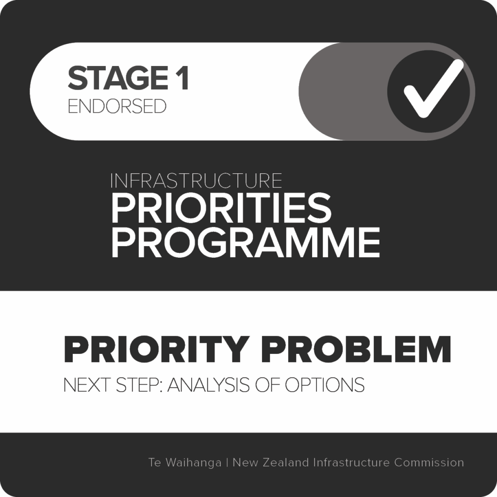
When it comes to endorsing projects, the IPP has three stages, which represent various levels of project development:
Endorsements are provided at three stages. Proposals endorsed at Stage 1 were found to identify problems requiring business case development. Those at Stage 2 focus on multiple options to solve the problem ready for detailed design. A Stage 3 endorsement reflects an investment-ready project.
Today, my proposal joins another 24 infrastructure proposals endorsed in Round 2, which along with Round 1’s endorsements means the IPP now has a total of 44 projects on its list.
As per today’s media release:
These include endorsements for Golden Triangle Rail Electrification, Waimakariri Eastern Transport, Auckland Biosolids Servicing, Auckland Level Crossings, and Queenstown Transport proposals as well as hospital projects in Tauranga, Hawke’s Bay and Palmerston North.“Each endorsed proposal has been rigorously assessed against criteria including strategic alignment with New Zealand’s needs, value for money, and deliverability,” [Te Waihanga Chief Executive Geoff] Cooper says.“We know that premature project announcements increase the odds of cost overruns and delivery delays. The IPP provides clear assessment of the investment readiness and the appropriate next step for each proposal.”The endorsed proposals, submitted by both public and private organisations, were assessed by the Commission and reviewed by an independent panel of five leading infrastructure experts.
It’s me: ‘Unaffiliated’
What’s actually been ‘endorsed’ for City Centre to Māngere rapid transit?
Given the substantial amount of work that’s already been done along the CC2M corridor, I submitted my proposal at ‘Stage 2’, putting forward light rail on the surface along Dominion Road as the preferred solution (at least for the section from the City Centre to Mt Roskill).
However, while my proposal satisfied requirements that this was a priority problem for New Zealand – and thus the problem itself could be endorsed – Te Waihanga found there was not quite enough information to endorse a particular solution… yet.
The report noted that these two key aspects were missing from my proposition:
- complete details on the process for longlisting, which should result in 8-12 discreet/standalone options, and
- evidence that price was sufficiently considered when filtering to a shortlist.
(You can read the full report here, which goes into it in a lot more detail.)
From my perspective, the major reason this proposal was endorsed at Stage 1 and not at Stage 2 is due to the haphazard process over the last decade of work on isthmus light rail by the various agencies, and in particular, by a lack of quality documentation of the work.
Unfortunately, there isn’t even one single business case to point to that contains a longlist and shortlist of all the options that have been looked at over the years.
For example, most of the work undertaken by Auckland Transport between 2014-2018 was not really documented in a proper business case. Still, that work carefully explored every possible lower-cost option, such as bus-based solutions, to address the central problem of public transport capacity constraints in the City Centre. Their conclusion was that Auckland indeed needed a higher capacity mode, such as light rail.
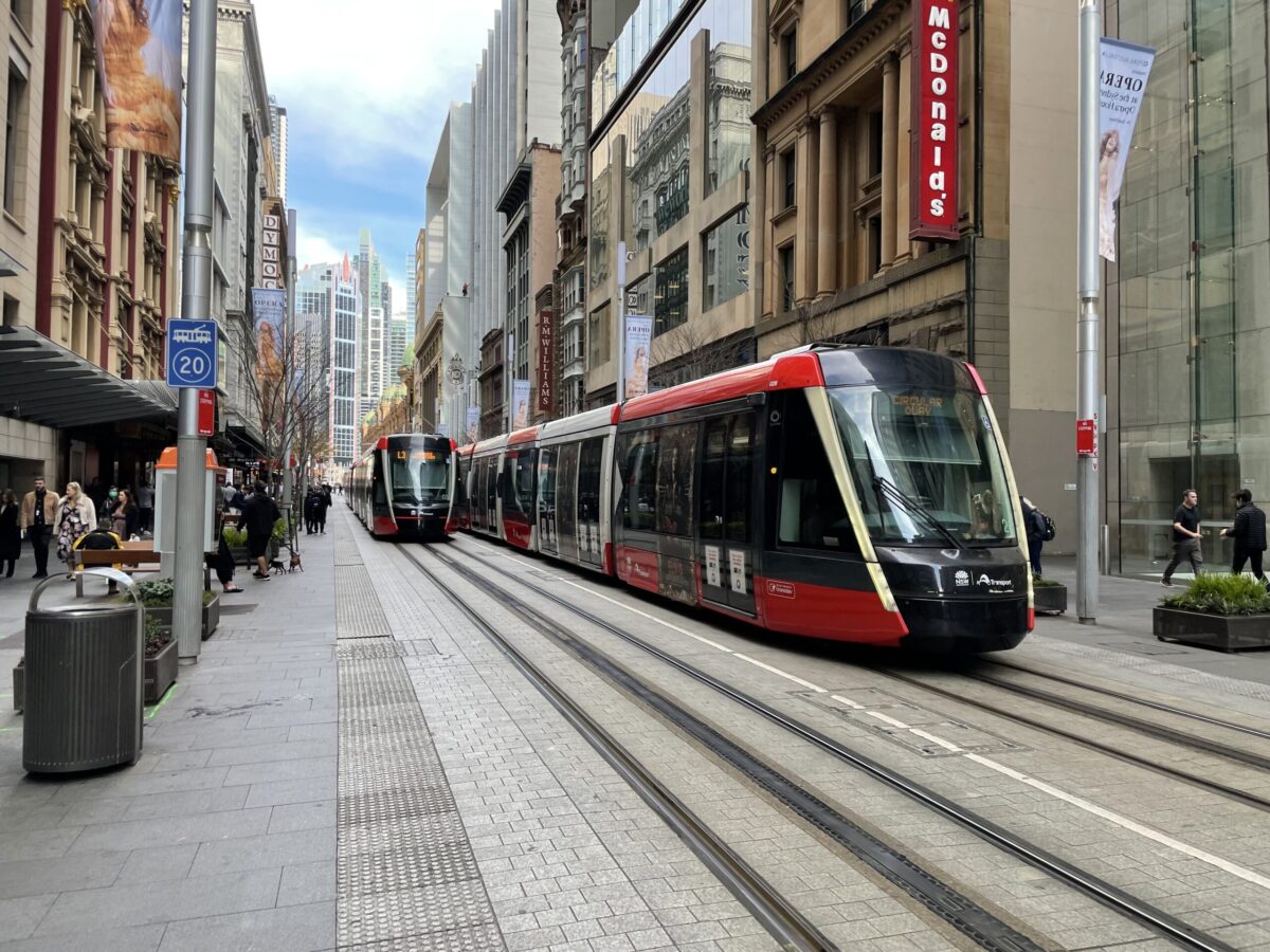
Surface light rail sliding along George St, Sydney. Could be us; could’ve been us already! photo Patrick Reynolds
However, despite all the work essentially being there to justify a higher-cost and higher-capacity solution like light rail, it isn’t available in a form that’s easy to pick up without having the prior institutional knowledge. Nor does it fit well into the standardised process of the IPP.
Additionally, as the Infrastructure Commission highlights in its report, the more recent work (and business cases) carried out in the 2020s didn’t take the step of quantifying what the ‘problem’ of the CC2M corridor ‘costs’ us – and therefore couldn’t adequately explain why higher-cost options like a tunnelled metro system emerged as ‘preferred’ in those business cases.
Combined with the significant cost of the tunnelled metro option – and evolving political attitudes – it is unlikely any of this more recent work would be progressed, or indeed progressable, any time soon.
Hence Te Waihanga endorsing my proposal at Stage 1: where it is clear there is a problem to be solved, and yet nothing substantial is currently being progressed in the way of a solution…
…or at least, not in the persuasive and quantifiable terms required for a Stage 2 endorsement.
Of course, it’s still a significant step to have won Stage 1 endorsement. It means that at least we as a nation have identified a pressing problem, and that this issue is on the list of things we should solve.
So what’s next?
The next step would be for an actual agency to pick this up – either from central government or Auckland Council – as I have probably reached the limit of what one individual can do.
As Geoff Cooper makes clear in this morning’s media release, receiving endorsement in the IPP doesn’t guarantee funding or prioritisation towards delivery:
“The programme is voluntary and open to anyone, from government agencies and councils to community groups and the private sector. This ensures we are able provide a list of infrastructure needs and solutions from across the country.“While endorsement doesn’t guarantee funding, or prioritisation by Government, it sends a strong signal to decision-makers about infrastructure priorities that have passed independent scrutiny.”
Arguably, as things stand Auckland Council is best placed to pick up this work. With Auckland Transport soon to be absorbed into Council, along with the development of the 30-Year Integrated Transport Plan, there is a timely opportunity to reignite work towards solving this problem.
At minimum, following the recommendations of the Auckland Rapid Transport Pathway 2025, a mode needs to be confirmed for the City Centre to Mt Roskill section of the CC2M corridor.
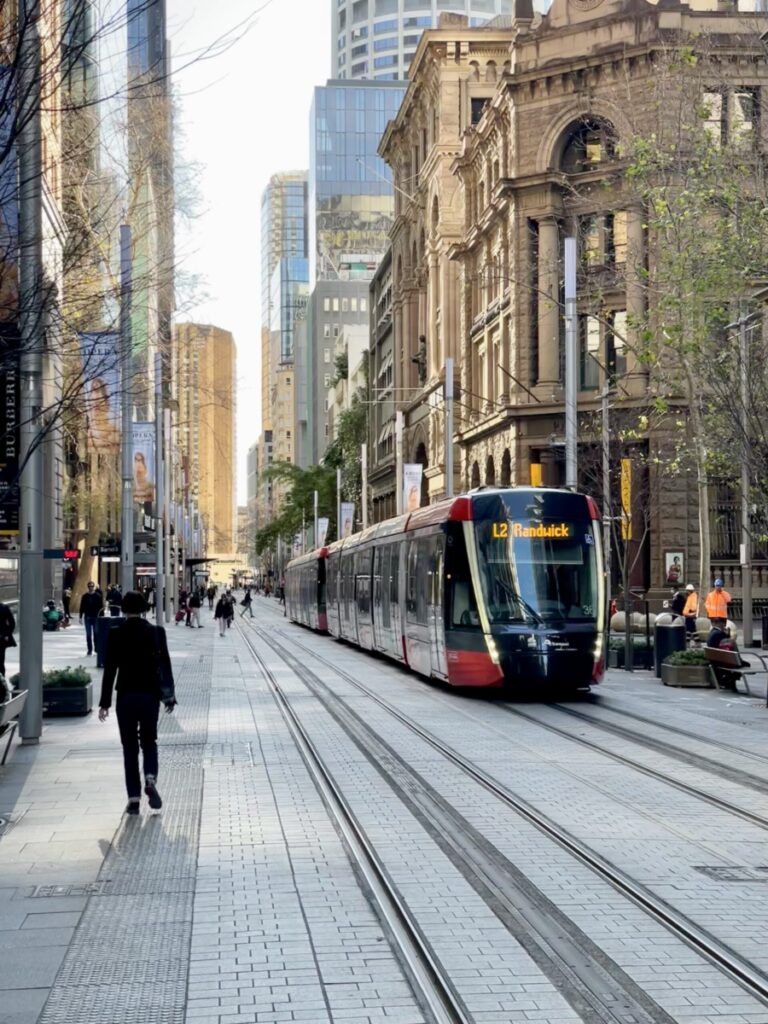
George St Sydney photo Patrick Reynolds
Further work could then compile and consolidate the existing work over the past decade, to advance development of the project, readying it for future business cases – or even lodging route protection and related Notices of Requirement.
Regardless of how (and by whom) this is picked up and carried it forward, I’m glad to have played my part (although I suspect my role in this won’t be over anytime soon). This is a really important step forward for a vital solution on a critical corridor, that has been left by the wayside since 2023.
Moreover, with moves imminent to develop the 30-Year Transport Plan for Auckland, you can expect to see a lot more from Greater Auckland in 2026 about what our city needs in the transport and housing space. So watch this space – as well as the CC2M one!
This post, like all our work, is brought to you by the Greater Auckland crew and made possible by generous donations from our readers and fans. If you’d like to support our work, you can join our circle of supporters here, or support us on Substack.
A render of Dominion Road light rail from Auckland Transport, 2017

 Processing...
Whakamihi.
The fact that the original project was shelved when it was so close and after so much consultation- and when ALMOST ANY SOLUTION was preferable to the status quo- still makes me so angry I probably shouldn’t be near a keyboard
Simple economics Steve. The cost was about 4-5 times the City Rail Loop which is going to cause our rates to go up by 7% just to pay the annual operating expenses. This light rail line is through a very low density area so the economics of running costs vs revenue would be even worse. In the overall scheme of things it is probably one of the dumbest projects ever considered in the entire history of NZ infrastructure projects.
Yes, although the Northland Expressway has since turned up to give it a good run for it’s money.
It is through an area however that *should* not be low density (and if any basic sanity remains, will not *stay* that way). And it didn’t have to be anywhere that expensive as tunneling etc caused it to be.
So yes, certain key assumptions and choices were bonkers, and thus meant that *this* specific permutation of Light Rail died a deserved death. But Light Rail across the Isthmus remains very sensible.
Well done on getting this on the list.
Ka Rawe Connor. The amount of effort and dedication you have put into this is very impressive. Having the problem recognised like this is hopefully a step toward a grown up conversation ( although that term is a bit redundant as I reckon in the hands of rangatahi we would have had a longer term view that considers people, place and planet)
I blame the stunning political incompetence of the erstwhile (Labour) Minister for proposing an option that cost so many billions that even Blind Freddy could see it was a complete non-starter. As others have noted, if the original AT proposal had been implemented, we would have had at least had light rail on the isthmus section fully operational by now.
They have reselected that twit for Mt Roskill. Labour as a party just doesn’t understand politics. Or maybe they understand but simply don’t care.
I assumed David was talking about Phil Twyford. Good to be reminded this was multi minister incompetence.
Good grief I had forgotten Twyford. No wonder nothing ever happened. Where does Labour find these people?
Is there any reason we can’t just run it as a bus way now – DX1. Use existing bus lanes and make them all day and position stops as per planned stations. This could be an even easier first step to light rail. Surely there would be efficiencies in runnung the corridor this way.
Yes we should do this immediately. But the existing bus lanes are inadequate because they all disappear at intersections, for traffic capacity and priority.
It can be improved marginally in the interim, but only by substantially fixing the Right of Way by reducing traffic space, can this route become truly effective.
This is what LR fixes..
Don’t forget the issue of bus overcrowding in the city centre too is another reason for using light rail.
$20-$30 billion and massive operating expenses to fix these issues seems like a very poor allocation of capital.
It wouldn’t be $20 billion if it was simple surface-level light rail.
8km @ $250m /km = $2b
Pretty straight forward civils , except underpass at K Rd, and bridge over m’way.
Depot and LRVs
@Patrick Reynolds even the early indicative pricing surface options were $9B. Back of the envelope costs per kilometre are where bureaucrats end up making us pay for massive cost blow outs.
Hey Mathew.
Connor’s plan is not ALR’s plan.
It is not tunnelled.
It does not go to the airport- from the bottom of Queen St to Mt Roskill by SH20 (depot location), only.
9-10 street level stations, like high quality bus stops.
Queen St, Ian Mak. and Dom. Rs only.
It is 8km of surface LR.
–
You are quoting costs for an entirely different thing.
The sensible way to scale up public transport would be creating the route space on the street along a corridor as the demand for transport rises on it. It is presumably much less disruptive to add light rail tracks to existing bus lanes section by section until the line is long enough for trains to replace buses.
Isn’t the real problem in Auckland that even our main streets are not wide enough for footpaths, separated cycleways, bus/LR lanes and general MV lanes in both directions, never mind any kind of trees or green strips?
When we design new suburbs, are we actually creating the streets that will be able to accommodate all of this if and when it is needed?
I agree busses are good, expecially electric ones. BUT the problem is that there is nowhere in the centre city that you can fit that many busses. That was one of the critical problems that had to be addressed soon the prospect of busjams was all too likely.
Surely a lot of that problem is solved if you get cars out of Queen St, have a chunk of buses terminating at Aotea (from North and West), and with the other bus priority improvements like Wellesley St?
It won’t fix it forever, but it will get us better rapid transit on that corridor much, much quicker and ultimately, prove the case for LR?
So much of our transport issues could be solved quicker and cheaper if we actively worked to reduce carbon numbers rather than just accepting them and trying to work around them. Looking at you NW busway
Should have been car numbers but carbon works too.
It is good business to build light rail where the patronage would be highest and the income a maximum. The lines need to be busy and get the best benefits such as replacing the greatest number of busses and cutting journey times for 1000s of people each day rather than a service for few people in a new distant suburb.
Trains stopping at stations to pick up a handful of people is not good business.
Light rail to the airport is the best choice and the returns for the city would be much greater than building RONS
“Light rail to the airport is the best choice and the returns for the city would be much greater than building RONS”
What is the constant obsession with Light Rail to the Airport. You can already get to the airport by using the southern rail line to Puhinui Station, then transferring the electric Airport Link buses, that run 24/7 every few minutes. Only a few percentage of trips to the Airport start or finish at the CBD. Most trips to the Airport are from worker bees who live in Mangere, South Auckland, or West Auckland.
Call it light rail to Mount Roskill, Onehunga and Mangere then. The airport is just a handy anchor at the end, not the only point of the line. The only people obsessing over airport to CBD trips are those clowns who demanded express heavy rail on a Puhinui branch line. Like the eastern line ending at Manukau, a handy anchor but not the only point of the line.
A lot of those airport ‘worker bees’ live in mount roskill, onehunga, mangere bridge and mangere, which is exactly why the line was planned to go through there. Combined with the bus from Manukau and Puhinui you end up with excellent access for workers from the nearby suburbs.
24/7 would be great… I will remember this the next time I get back at 9pm on a Sunday (with hundreds of other people).
Firstly, I respect the advocacy from Connor, this is a cool achievement.
Secondly though, I worry about prescribing that Mt Roskill has to be on a City Centre to Māngere route. I’ve come around to the view that the ideal (and probably too expensive) solution for Māngere and Auckland as a region would be a fairly direct automated metro following Manukau Rd. However, the most recent ALR process discounted this since it skipped Mt Roskill. Instead we ended up with a bloated metro to Sandringham Rd because the govt happens to own land there.
The ideal solution for Mt Roskill probably is light rail on Dominion Rd. It’s a successful and straight bus corridor so an upgrade to light rail eventually makes sense. Extending that to Māngere I think is inherently a compromise. It would mean slower travel times from Māngere to important destinations due to on-street running. Meanwhile, longer stop spacing on Dominion Rd would disadvantage a lot of the shorter journeys being made along it. I’d probably still take it but I’m less convinced than I used to be.
There’s also the question of whether this corridor is still an immediate priority due to improvements in the city centre to manage bus volumes and new bus routes in Māngere, but I’ll leave that there.
Agree with this. Have a Centre-Street light rail up Queen Street and Dominion Road. Thats is only around 7-8km and can be built in stages. It is a good first projects to fill a need and get something actually built.
As it grows other projects can extend it or reuse the technology.
A metro is a better solution for longer distances, higher speeds and capacities such as the CBD to Airport. Trying to shoehorn Light Rail into that was what sunk it last time (as it started going in a tunnel to gain speed etc).
That’s the beauty of modern light rail is its tram like in places and Metro in others it’s the ideal corridor to combine the two. It has long Street sections running alongside the motorway etc there’s not really that many stops so the speed for a one seat ride all the way to and from the airport and city centre is not that bad. Start with surface to Mt Roskil and take it from there depending on success and other factors.
“Trying to shoehorn Light Rail into that was what sunk it last time (as it started going in a tunnel to gain speed etc).”
That’s right. It wasn’t sunk because it was LR, it was because it was LR in a tunnel. HR in a tunnel would have suffered the same fate.
Agree, only prio atm is getting City Centre to Mt Roskill, rest is a bit of an open question (a metro system might be better tbh, but needs more work)
Am dealing with the constraints of what the last work actually looked at and was named though! I expect any work done in the near future will be focused on that initial stage on Dominion Road.
Light metro is effectively a non-starter due to the massive cost involved. We saw what happened when ALR went bonkers for tunnelled metro lines, the cost and impact and timeframe ballooned out into never never land. Manukau Road for a tunnel doubly so, as its the worst kind of volcanic rock the whole way.
So it’s back to the surface, which means the direct straight line down Queen Street and Dominion Road and SH20 is the quickest, cheapest and easiest alignment. A big part of the issue with Manukau Road is the circuitous route from the city centre through Newmarket . Basically in the time it takes to get from town out through Newmarket to the start of Manukau Road (with another 6.5km of street corridor to go to Onehunga), light rail on Dominion Road would be through Balmoral already and have only two kilometres more before joining the grade separated motorway section.
As connor says, all of these corridor options were looked at in detail, and Queen and Dominion was easily the best. It’s only when they decided that it had to be tunnelling that they needed to bend the tunnel around the volcanic lava flows coming off Mt Eden. I guess people don’t realise that, the only reason they diverted around via Sandringham is that’s the only place they could build a tunnel. If you don’t demand it’s in a tunnel, you don’t need a crazy deviation.
Good stuff. Probably good we keep the Airport out of the project or title for now until the badly handled saga is forgotten somewhat. .
Congratulations Connor for achieving some recognition for your reasoned advocacy.
The centre of the isthmus, the bit directed by Dominion Road, undoubtedly needs more public transport capacity.
Initially some of this can be achieved by busses, and bus lane improvements, and route capacity, and speed ncreases, by a further reduction in parking on Dominion Road, and further restricting right turn options.
But capacity increases by busses will reach a limit.
Then surface light rail, as an initial stage of a more extensive light rail network seems to be the best option.
Transport improvements to and from the airport , especially to the north is a different problem. Once the CRL is operative the current Bus Train link will be far from bad, for connecting to the CBD, and to the rest of the heavy rail network
I am far from convinced of the wisdom, at this early stage, of attempting a combined solution for the central isthmus and the airport.
Agreed. The “orange” airport bus to Puhinui station is very good. At some point capacity will mandate 2 versions of it, one to domestic and one to international but for now it’s fine.
The airport are comining their domestic and international terminals, so there will be no need to split the line.
From an Auckland-centric point of view, heavy rail to the Airport may not make the most sense (compared to continuing to improve the existing Puhinui bus link or even light rail via the Central Isthmus).
Where I do think a heavy rail proposal might have legs, is if the potential benefits to neighbouring regions were factored in and catered for.
Assuming that Te Huia is improved (and extended to the Bay of Plenty); then a direct link to the Airport from the NIMT could be of real regional benefit to not only Aucklanders, but the whole ‘Golden Triangle’ – over 2,500,000 people!
That said, realising such a benefit would be dependent – as stated – on some pretty substantial improvements to our inter-city rail services (and there don’t appear to be any concrete plans in place to implement any such improvements).
Therefore, the whole thing is moot.
Excellent work helping to keep light rail on the radar (especially in such frustrating circumstances).
I just thinking ripping up Dom Rd for a few years is a dicey prospect, with the experience of Albert St (far shorter) still so raw.
24/7 bus-lanes, remove on-street parking, bus priority at intersections (doesn’t the Mayor keep talking about “transponders”)? For the car lanes remaining, no right hand turns. It wouldn’t cost that much and you could have a step change in PT along that corridor.
Once its full its full and there is no option but to move to LR. In the meantime, identify another (easier) route. Prove its worth. Have everyone see it and want one. Then progression is a lot easier.
Dominion Road light rail is the only real viable first line. Also, the difference between disruption compared to Albert, is sections are only rebuilt for a few months, and then work is moved to the next section.
Better bus priority in the meantime isn’t a bad idea though. However, as you still hit the core issue of City Centre spatial constraints, much better to go to light rail as quick as possible!
You guys are just going through the 7 stage grieving cycle.
Time to move beyond the Denial and Bargaining stages.
Does bargaining include paying for a light rail line through my taxes?
At this rate of progress the technology is likely to change. A modern monorail can be built in a smaller footprint than elevated lightrail. The Sydney lightrail at surface level regularly posts videos of near misses between people/ cyclists and light rail units. Would an underground hybrid trolley busway work? Modern trolley buses are lighter than battery buses. Smaller lighter non-flammable batteries with a 10-20 kilometre range. Above ground bus stations so underground stations are reduced or eliminated. Entry/ exit ramps in local parks. Underground is more expensive, but not shading houses with elevated concrete like the bus ‘Sunway line’ in KL. At what point is Auckland Airport better to share the domestic load with Hamilton and Whenuapai, rather than having 51K passengers a day headed towards Mangere.
Thank you Connor for the work you’ve put into this.
Although the fumbling of the project by the last government was depressing, hopefully it won’t take too long to be reworked as a sensible project. Auckland was obviously built for light rail, so it’s time (like almost every other city internationally) to bring it back.
Yeah, especially in the isthmus (if only we didn’t pull out the tram network!)
I suspect many Aucklanders were disappointed that the light rail project didn’t progress. It’s clear that the existing status quo will eventually result in gridlock.
Unfortunately, the project was hampered by too many cooks spoiling the broth. Further, its possible that traditional light rail may not be the best solution.
To expand upon that point, I understand that Brisbane has implemented a hybrid light rail system that operates like a bus. It looks like light rail but does not use rails and is driven like a bus.
This concept would seem to integrate well with Auckland’s road network as well as the multiple busways popping up everywhere.
One of the big issues is lack of rapid transit to the airport. This goal from the original light rail was always flawed. Current airport link buses work well but would be an enigma to newly arrived tourists.
A hybrid bus/light rail service would dovetail in quite nicely though. As part of a larger expanded network, I could see it being first class.
The goal of the original light rail was never about the airport, it was about rapid transit access to the isthmus and Māngere, and space constraints in the City Centre which limited bus based options.
None of that has changed, particularly regarding the City Centre and so any bus based solution (including these ‘hybrid’ buses) will not work – and this also ignores the many other issues with those types of buses.
All of these options have been looked at in extensive detail. Only rail based solutions are sufficient to deal with the problems.
Brisbanes “hybrid light rail system” is articulated buses running on their busways. So yes, we could do more busways, or run bendy buses on the ones we have. But take a look at what brisbane has there, it’s a veritable motorway network for buses. A lot of tunnels, underground stations, flyovers and ramps for buses. We can’t really afford that level of grade separated infrastructure, which was the reason for a high capacity surface transit option in the first place.
Incidentally I’m travelling from Mt Roskill to city this morning. 1hr according to the app! I’d be better off living in Papakura.
10 mins of that is the walk from my house to the bus stop (fair enough), the other 50mins is the combination of a very slow bus that takes a stupid route (25B), and the fact it terminates at Aotea so I then have to walk 15 mins to Britimart (I’m sure they were meant to run this bus to Britomart one day, but for some reason that’s one day is like 20 years away).
Auckland loves to encourage sprawl by giving gold played PT to those who live miles away, and buses that average 10kmh to the central isthmus. The inside out city.
How long to cycle
Depends if you die or not
Mt Roskill spur?
Yes. Clearly the best option.
i’m sure Balmoral residents will greatly enjoy backtracking to Mt Roskill to get the train into the central city /s
I’m sure they would love backtracking then being connected to all other train stations on the network with a variety of places to go. Lucky them
Can someone give any figures for the light rail?
Such as
10,000 people per hour
30 stops
At 25km / hr
Costing $3 billion?
Adding stops will make it cost more and go slower the reverse for moving some
Do stops for light rail really cost much? The cost is moving underground utilities and whatever hideously expensive measures taken to alleviate street closures or widening these idiots decide on
A guest post on Greater Auckland from last year estimated that Waitemata to Mt Roskill could cost $150 million/km (for a total of $1.35 billion).
Plenty of figures out there is you just google them.
Queen St to Mt Roskill
9-10 stops
$150-250m per km
faster than current bus, fewer stops, more direct route (Ian Mak not Mt Eden Rd), signal priority, no competing traffic at stops.
9,000 people per hour each way (66m units x three minute headways).
23km long, 1/3rd road median with signal preemption, 2/3rds grade separated along the motorway.
17 stations, 9 of which would be simple platforms in the road median.
Average speed end to end, 30kmh including stops.
Thanks John
The question is how do you optimally manage an intersection which has 66metre light rail trains run through every 90 seconds? You could have left turns and straight through with the train. I worry that right turns and cars crossing the train may not get enough time. For quieter places it would be OK but could Balmoral crossing dominion still work?
It’s really not a problem, signal preemption is something that is done the world over and it’s very routine in this case. Very simple four way intersection with few lanes and short crossing distances. Believe it or not, AT did work out these things before including them in their plan.
Yes, the light rail would run on the same phase as the through traffic along Dominion Road, which is also the same as the pedestrian crossings going north-south, and also left turns at the same time (held for pedestrians) or keeping the slip lanes.
The main point is there is already way more green time for through traffic than the light rail would ever need. A 66m vehicle crossing a 50m intersection like Balmoral takes about 20 seconds. The green light for traffic on that phase currently runs about three times that, getting about 60 seconds out of every two minute cycle to clear the queues.
The difference would be pulling forward or delaying the main green phase to suit the approaching trains. But that is just shuffling it forward or back in time, rather than making it longer overall, the following phases just get shuffled accordingly. The total phasing time needed for traffic will still be much longer than the trains need.
Also it’s fair to point out that 30 trains an hour in both directions at the same time is like a maximum capacity that the line is seldom, if ever, going to actually need. And every 90 seconds is only if the two directions perfectly offset on the schedule. It’s just as likely that the two direction arrive at the same time and use the same phase every 180 seconds.
In early years and across almost all of the day it would be something like one every five minutes (12 an hour each way). That means potentially adjusting every second or third green phase, while the majority run for traffic only.
Not convinced that longer than 45m units would be needed, certainly for first decade. Otherwise fully agree with your analysis John.
I recall that right turns on Dom Rd would be done away with where LRT was deployed? Is that correct?
Only at unsignalised midblock side streets. The right turns at the lights would remain, and would allow a u turn with the right turns. So for those side streets you drive up to the next lights and turn back. Which is probably easier than doing an uncontrolled right turn today.
Forget about light rail just extended the Onehunga heavy rail down the motorway to the airport. That what you do when the population of auckland is 2 million The cost nothing compared with anything else
IF Auckland were to go back to the Light Rail project, they should say nuts to tunnelling (an absurdly expensive option in the Anglosphere), and instead look more towards a Vancouver Skytrain elevated solution. You get the much-needed grade separation (just look at Toronto to see an expensive new surface-level LRT that’s slower and less frequent than the buses it replaced), for a much lower cost.
Plus, trains with a view are much better than looking at a dark tunnel wall anyway.