This is a guest post by Peter Bisley. It previously appeared on his substack, and is republished here by kind permisison.
How can active transport connections maximise City Rail Link benefits
City Rail Link successfully ran a test train last month on the 3.45km line under central Auckland, ahead of its 2026 launch. CRL doubles central network capacity, providing two new stations, Karanga-a-Hape uptown and Te Waihorotiu midtown. It redevelops the waterfront Waitematā (Britomart) terminal as a through station and Maungawhau (Mt Eden) as a junction directly connecting Western Line to the city.
The fourteen Western Line’s stations will immediately see substantial time savings from CRL. Peak public transport from Henderson to Te Waihorotiu Station on Wellesley St in central Auckland reduces from 59 to 35 minutes with similar time savings across the line.[i]

Generating walk and cycle catchments
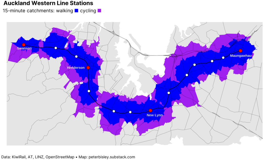
Direct travel to the city encourages multimodal transport. To analyse walking and cycling potential of the Western Line, catchment analysis tool R5 calculates pathways that people take to a station and builds boundaries showing how far they can travel in a certain timeframe.[ii] It accounts for uphill sections using digital elevation from LINZ and uses road and pathway data from OpenStreetMap.[iii]
Across the Western Line, 95,900 people and 30.2 km² are within 15 minutes’ walk, with 166,900 and 54.7 km² within 15 minutes’ walk or cycle.[iv] I’ve made an online tool to view the catchments for each station.[v]
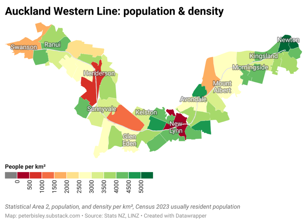
Understanding population density
We have detailed Statistical Area 1 & 2 population counts from the 2023 Census. This includes area for density and 2018 and 2013 data, showing 5 and 10-year growth. SA2 boundaries reflect “communities that interact together socially and economically”, while SA1 are designed to have 100-200 residents, for geographically detailed analysis. CRL formally started in 2013, so Census shows how the city has grown in that time.[vi] The map below shows population and growth for SA2s near the Western Line.[vii]
Combining catchments with population
For cycling and walking, the finer detail of the Statistical Area 1 gives more insight. Applying a 15-minute walk and cycle catchments and overlaying the SA1 data, shows the population that can potentially be served.
The Henderson town centre has few residents but there are pockets of density further away. With the right infrastructure and facilities, cycling increases station catchment to 14,600 people and 6.5 km² vs 4400 people and 2.5 km² walking, as shown by the black dashed and solid boundaries.

New Lynn, the major transport hub on the Western Line, shows a similar development pattern to Henderson, with significant proportions of the area close to the station having a low density. The 15-minute walk catchment of New Lynn station are 7500 people and 2.7 km², increased to 24,100 and 7.1 km² with cycling.
 The online tool to look at catchments for all the stations on the Western Line is published here, and also shows the Auckland Unitary Plan zoning for each station. I’m keen to hear about other projects using this data to analyse the combined potential of active transport and rail.
If you liked this post, subscribe to Peter’s Substack here.
[i] As far as I can tell, a full listing of projected travel times is not published in one place but can be interpolated from existing travel times, CRL FAQs, and Auckland Transport.
[ii] This assumes a 5 km/h walking speed and 15 km/h cycling speed. I intend to iterative the online tool online tool so it can show multiple travel time and speed scenarios.
[iii] The open data produced by New Zealand Government organisations and used here is licensed under Creative Commons – Attribution 4.0 International.
[iv] It also allows specifying the maximum level of travel stress while biking, which means that certain busy roads can be excluded from routing.
[v] This and subsequent population figures calculate the proportion of the SA1 land area covered and assumes that the population is evenly distributed.
[vi] Government support was initially announced in 2013, and was brought forward in 2016, based on strong rail passenger and population growth.
[vii] The Western Line is accessible to and used by people living much more widely than these SA2s via bus links, park & ride and active transport, but I’ve just shown the adjacent and near-adjacent SA2s.
This post, like all our work, is brought to you by the Greater Auckland crew and made possible by generous donations from our readers and fans. If you’d like to support our work, you can join our circle of supporters here, or support us on Substack!

 Processing...
Why is Henderson town centre so low population? Are there development constraints on building residential?
I don’t know the zoning but a quick look at Google Earth suggests it is industrial. Even if it has already been rezoned for high density it will take some time for this to flow through to actual building.
There are limited planning constraints to residential or business intensification within the town centre, and surrounds except to the south of there is a large industrial area (where residential is not enabled) with a a number of fairly noxious activities. Fairly large employment area tho. The rail line itself is a barrier to connectivity and a classic disamenity (its not that nice to live next to). While Henderson could be different if there were demand, not everywhere can (or should?) be an origin, some locations can be destinations for people from other catchments too. Thats the point of transport – moving people to where they want to go from where they are. Overnight that seems Henderson isnt where they are, but is probalby where many need to be during the day to go to work/access other things that are there (court, pools, services, malls, pool etc)
There is a huge amount of land tied up in the river, park and flood land. There is also a heap of industrial, commercial land. AT also have a rail yard within the walkable catchment.
Every suburban centre has this pattern. In the centre you have shops, but no homes. There is always a strict separation between those two. It is the lingering magic of single use zoning. You almost never see apartments above shops. Even in the city centre it is still obvious which blocks used to be residential and which weren’t.
And yes this makes a lot of things suck much worse than normal. Public transport is generally hard to reach from people’s homes. Apartments are strictly worse than houses because, to materialise their advantages you need to put them actually inside those town centres.
There is a lot of business zoned land near Henderson station (check out the online tool that shows zoning too), but essentially there is a tremendous opportunity to build residential and mixed use properties near Henderson and other stations.
Have you considered extending your study to include Waitakere, Huapai, Waimauku and Helensville? You might find some compelling results, particularly around past and future population growth in Huapai.
An extension of the train service to these towns will certainly happen one day.
Agree, I think the really interesting extension for me would be to link into a wider North Western view including Kumeū and Huapi etc.
Every time I go out that way, past the North Western mall area (like the Costco there) I am stunned by the amount of building going on with what appears to me to be minimal attention to public transport.
The roads will become be increasingly congested and there will be calls for motorways and widening, massive interchanges etc, but surely we have people in Auckland Council talking to NZTA and planning solutions for the future.
They made a short sighted decision to not put in a busway when widening the Northwestern motorway, but could they not at least look at allocating some space for light rail or busways at the very least along SH16?
We still don’t seem to be building for the future
“but surely we have people in Auckland Council talking to NZTA and planning solutions for the future.”
Sure we do! More roads to green field developments 🙂
Remember who was in government when the NW motorway was widened but didn’t include land for the busway when it was cheaper.
Roads out there are already congested, and they’re already in the planning stages to extend the NWern out further past Kumeu etc.
They’ve also got a rapid transit corridor planned, but unlikely anything will happen on either until funding. The motorway extension is a Rons tbf.
Hi Richard – yes, planning to extend it to all current stations, as well as planned and inactive stations. In addition to showing potential, my focus was to show areas which will immediately be enhanced by CRL connectivity without anything else needing to happen. Thanks for the feedback.
Wonder if they are actual planning to coordinate with other plans they have for the area https://www.rnz.co.nz/news/national/542208/auckland-council-proposes-to-move-kumeu-due-to-flood-risk-community-leaders-onboard
Yes sorely needed and long overdue (even before the exponential growth that has taken place in the area).
The line has been upgraded, is currently only used up to twice a day per direction. It is quite frankly madness that this piece of infrastructure is not being used! It’s not just AC/AT, it’s this blog as well!
On another note, there looks like there could be a good potential for an additional station where there is a gap between Sunnydale and Glen Eden.
don’t forget – over an hour total travel time to the central city even post-CRL, 2-4 years for rolling stock to be procured/refurbished, an hourly service at best without investment in a crossing loop in the region of taupaki which does not come close to counting as frequent rapid transit; and if you wanted a double track full-frequency service the cost of duplication, electrification, and daylighting the Waitakere tunnel would likely be in the same realm as just extending the northwestern busway.
can the heavy rail dogmatists at least acknowledge that these criticisms of the heavy rail to huapai option aren’t unfounded?
That’s because most of those are simply artificial barriers (put in by anti-rail) that needn’t be an issue (at least in the short-medium term).
1: An hour in a nice comfortable train where you can rest, or do something else vs sitting in traffic the whole way often taking even longer?
2) No, 30 minute frequencies can easily be achieved with existing infrastructure. A passing loop is relatively inexpensive if really needed in future.
3) No need for double track unless you want to move to 4TPH or higher each way frequencies.
4) Electrification not needed now. Can use DMU or get some BEMU.
5) Daylighting not needed in the medium term. Can make some minor modifications to the tunnel to allow for egress, or take measures to further mitigate the very very small risk.
The busway isn’t even under construction to Westgate let alone to Kumeu (or beyond!).
Meanwhile we could have a decade of excellent rail service. Once the busway is eventually built can reassess then. Both will probably be needed especially if the trains can continue on to Waimauku and Helensville (both of which are rapidly growing).
again, the rail dogmatist ignores my very critical point that 40+ year old DMUs and carriages rusting away for years at Glenbrook and Taumaranui are going to take YEARS to refurbish. Remember it took 2 years for the Te Huia sets to be finished.
in that timeframe, for the same cost, you could stick bus shoulder lanes on SH16 from Brigham Creek to Kumeu and have the WX1 running every 15 minutes all day, 7.5 at peak.
“excellent rail service” ah yes all of a sudden the speed and track plaguing the rail network vanish when you need to cherry-pick for your preferred option – not to mention bureaucracy. sorry “realist”, you’re not being realistic and you’re only re-proving the point that the heavy rail cult cannot take criticism or engage sensibly in civil debate over transit modes.
I’m sure some of the DMUs are salvageable. Failing that, there will be some available second hand on the international market or hot swap out some of the EMUs for BEMUs. Failing all that locos until new units can arrive. Stop thinking if obstacles and being in the box, try thinking outside the box for a minute.
Even the most pathetic temporary style shoulder bus lanes from Brigham to Huapai would take at least 2 years of planning and then another 3 years to be built MINIMUM and would cost around $300m MINIMUM (that’s not even including the need to widen bridges).
Adding on rail to Huapai would have no impact to the rest of the network (other than more pax). The existing issues are being resolved and once CRL opens growth will explode.
Stop being a negative Nancy, we get it, you don’t like trains. Most people prefer them to buses… especially when they can be running long before buses can operate a similar service.
bub, I hate to break it to you, but if you want better public transport to Huapai *tomorrow*… buses are the way to do it. not rusty graffiti-scrawled trains. that’s not thinking inside the box, that is a realistic practical consideration informed by how long it took to refit the Te Huia carriages.
Please cite sources and examples for your costing. Pre-Covid the costing for the Brigham Creek to Waimauku four-laning that fell through was $53 million – so $70 million with inflation; and I’m only talking about less than half of that, the 5km from the end of the Northwestern to the start of Kumeu town. Same cost as 5 more EMUs from CAF.
Even if you doubled that – still half of your wacky baseless figure for a bus improvement option.
I’m not anti-rail, in fact I’m being far more realistic than you are; what with your dramatically distorting reality to fit your agenda. That is what I’m opposed to, not the concept of a train beyond Swanson, but this pigheaded hostility, bias, and fragile inability to accept ANY criticism of what you propose.
and please enlighten me where exactly you’re going to find second hand DMUs of 1067mm track gauge, of dimensions <3750mm high and <2820mm wide?
your claim of half hourly frequencies doesn’t hold up either.
Swanson to Huapai was 19-20 minutes on the Helensville train timetable. In an optimal situation a multiple unit would be faster than a loco-pushed carriage set, maybe down to 12-13 minutes Huapai to Swanson with optimistic average max speeds, but as reality shows us the electric trains aren’t being operated faster than the diesel trains across the rest of the network, so realistically the 20 minute travel time would be more likely.
so a 20 minute one-way journey, 10 mins layover during which the train can recharge its batteries. fast charges could be done in a minute and a half, although this degrades the battery and a gentler 5-10 minute charge would prolong battery life. one BEMU would therefore be able to do an hourly service going back and forth.
For a half hourly service, two trains would be needed; going back and forth at the same time – they would meet roughly 4 minutes north of Waitakere station, or 1 1/4km north of the Taupaki Rd level crossing; where there is currently no passing loop. So “Realist”, your assertation is false; a passing loop IS needed for a half hourly frequency on the Swanson-Huapai run.
To achieve a half-hourly service without a passing loop, you would need a single BEMU be able to do the whole round trip including layover times in 30 minutes. A 12-13 minute one way trip might make this feasible, however a 2-3 minute turnaround time is *very* tight when the current turnarounds at the termini on the other lines are in the region of 4-7 minutes; so I believe it’s fair to say such a schedule would be infeasible.
“…you don’t like trains”.
Nowhere near as much as you hate buses.
So now is the opportunity to rezone anything within these catchments to twenty floor apartment blocks.
If it is only going to take such a short time to travel on the train line, we can start building practical solutions to our endless lack of homes in our city. Within our existing footprint. At least then we might have some half respectable density in suitable areas.
Remaining hopeful
bah humbug
Bishop is on to this, isnt he.
In related news, while commercial rather than residential, Bishop is railing against a council decision to decline approval for an 11 storey development right next to the new K Road station. Article in today’s Herald, behind the paywall.
Apparently the heritage of the area, including presumably the vacant lot this development is proposed for, would be harmed. Crazy.
Yep just read that – we are completely fcked with these sort of commissioners denying this.
“Civic Trust Auckland has long advocated for the protection of historic heritage, and we consider that the building as proposed in this application is likely to have negative effects on the heritage values for which the Karangahape Road Historic Heritage Area is scheduled in the Auckland Unitary Plan,” van Ryn wrote for the trust.
Wtf does that even mean – is it all just “reckons” – K Road heritage? A grimy road cut in half by a huge motorway.
Up to 400 workers in that building, eating drinking and shopping on K Road.
“No thanks. We are fine with it the way it is”
You can draw a circle around every stop except Swanson? There seems to be land in the walking catchment not accounted for. It’s almost like some ridiculous invisible barrier exists to prevent development.
Henderson could be close to 30mins if we sorted out dwell times.
On a recent visit to Perth I recorded a few Dwell Times.
25 seconds at a small one on one off station.
In Wellington at night on the Johnsonville Line the Guard would walk through the Unit and ask if anyone wanted the next Stop. If, no-one they would communicate that to the Driver who would not stop unless they saw someone on the platform.
AT could do much better!
About 1968 for the Jville Line comment.
The dwell time in Wellington is 30 seconds for a smaller stop. It’s clear shorter dwell times are viable in NZ with a train manager at the door, why can’t AT get this sorted?
West Auckland gets next zero bike infrastructure, what does get built is either meters of insane cost shared path or silly things. There is zero effort to building out a network.
The New Lynn bike network was funded via CATR and AT have wasted 4 years and are now, starting the design hat will completely ignore the previous reports and plans. Will there be another round of consultation?
While your “outer zone” has ok biking, going to anywhere else is going to be either slow, dangerous or impossible. Nothing getting built needs to be an assumption.
All the land that was left as white space for Auckland Light Rail could now be rezoned to take CRL opportunity, even if City to Mangere rapid transit is dormant. A good opportunity for the govt. to look at value capture to fund supporting infrastructure.
New Lynn being so low-density with that big of a transport hub is so embarrassing.
I live a 15 minute walk to New Lynn station, and during my walk I day-dream about the massive potential of the former clayworks site. I assume it is being landbanked and has industrial contamination. Minimal parts of it have been developed over the past few years on the edges furthest from the station. Townhouses galore.
There is a failed development showroom that is slowly falling to ruin. If I was king I’d have taken the land for a Unitec style redevelopment of a modern urban-apartment-green-park-village. https://www.google.com/maps/@-36.9128401,174.6839765,523m/data=!3m1!1e3?entry=ttu&g_ep=EgoyMDI1MDMxNi4wIKXMDSoASAFQAw%3D%3D
Very interesting and timely, especially in light of this article: https://www.stuff.co.nz/sport/360620834/revealed-first-images-new-auckland-stadium-complex-steven-adams-joins-all-star-backers
Unfortunately, it seems the proposed stadium would be a half-hour walk from the train station at Morningside.
Oh gosh, please lets not waste another year of political air on another stadium discussion. Wasteful in so many ways. Argh, Auckland.
Its a private development.
the data may not be there but would be good to overlay employment density too as residential not the only factor
Can’t really move the site of the current “stadium” that this replaces. It is what it is.
On the bright side, presumably its quite close for New North Road buses, a little more of a stroll away from the NW Express stop nearby?
Great North Road buses, apologies.
GNR buses are super frequent. It’ll be a stop on whatever NW rapid transit project happens, along with at least one place in the CBD, Pt Chev, Te Atatu, Lincoln Rd and Westgate. I guess they could divert the WX1 during game day matches, as long as the bus lanes on GNR are operating, should be fine time wise.
And I am going to (optimistically) assume that once the NW rapid transit is up and running on SH16, there will be a fairly convenient bus between the Western Line (Baldwin Ave?) and the NW rapid transit stop at Western Springs.
So not too difficult for those on the rail lines.
I already hybrid commute Sunnyvale to City, jumping off at Grafton to cycle down to Victoria Park. That saves the Grafton Newmarket drag, cycling knocks 40min off the trip compared to walking to/from stations each end. See blog post (the ‘website’ link on this comment) for more on that and how the folding bike I use is (now) free.
The real problem for mixed mode is bike capacity on trains. This is especially with AT hardware limitations meaning they run some 3-unit (so one for bikes) trains at peak. Running 6-unit trains would massively increase capacity without increasing frequency.
Yes, the hybrid commute is great or even for casual trips is great.
Surely you can cycle further in 15 minutes than you can walk. Yet in a number of places the purple area does not extend past the blue area. I’m looking in particular to the east of Henderson and Sunnyvale but there are other areas where the same thing occurs.
In some places the algorithm (rightly or wrongly) may assume that you can’t walk OR cycle further (because there is a barrier, like a stream)?
In other places, the walking and cycling networks the program uses to calculate distances may differ – i.e. a path may not be considered wide enough to cycle on, so the bike route goes “around the block” instead, and thus doesn’t reach as far as expected…
The algorithm uses the road and path network but also includes a “maximum level of travel stress” parameter for biking, and I’ve used 2 as a default. This is because I wanted to reflect a realistic scenario for most people in the current state road and cycle path network. Some people will be confident enough for busier roads, but there are definitely areas where it is not possible to go faster than walking without using a busy road that most people wouldn’t feel comfortable cycling on. Full definition “LTS 2: Except in low speed / low volume traffic situations, cyclists have their own place to ride that keeps them from having to interact with traffic except at formal crossings. Physical separation from higher speed and multilane traffic. Crossings that are easy for an adult to negotiate. Corresponds to design criteria for Dutch bicycle route facilities. A level of traffic stress that most adults can tolerate”.