This is a guest post by Jessica Rose. Jessica is a member of the Whau Local Board, a sustainable transport advocate, and co-chair of Frocks on Bikes Auckland.
The New Lynn to Avondale (NL2A) shared pathway has been in planning and now delivery for the better part of a decade – and it’s going to be completed in the next few months. NL2A starts where the Waterview Path ends at Blockhouse Bay Road, and other than a detour through Chalmers Reserve, runs along the rail corridor until it terminates at the New Lynn train station.
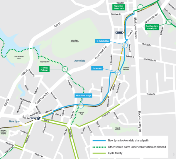
Dempsey-Wood, the contractor delivering the path, sends out a newsletter every month or two to anyone who’s found out how to get on the mailing list. Auckland Transport themselves haven’t shared much information since their last newsletter in mid-2020. But a lot of progress has been made. While there is much to celebrate, there’s a couple of things that stand out.
Just last week, the local board got their official first ever walk through of the project they’ve been funding for the last few years.
Road crossings: the good, and the not-so-good.
The first thing of note is that throughout the journey, the road crossings scream with inconsistency. There are 8 road crossings along the pathway. Every crossing is a different design.
There are beautiful best-practice ideas at St Georges Road and Portage Road. The St Georges Road crossing (my personal favourite) has a raised table, crossing lollipops with traditional pedestrian stripes and a green stripe for people on bikes. The Portage Road crossing is a fully controlled signalised crossing, following a successful example in a similar situation in Penrose.

An excellent crossing at St Georges Road
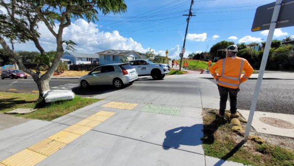
But on the other hand, there is a visually indistinguishable raised table on Chalmers St. This crossing steps out from the children’s playground into a low-visibility road corridor that people in vehicles hoon down at breakneck speed. After the Chalmers St crossing comes another road crossing that has no new safety infrastructure at all, at St Jude St at the entry to the Avondale Train Station. An old pedestrian refuge is retained, and some curb cuts have been installed, but there’s not even a clearway painted so that vehicles queuing for the level crossing can leave space for people on bikes to get through. A similar design happens in New Lynn on Veronica Street.

Where the shared path crosses St Jude St
So how were these outcomes chosen? Why is there an excellent crossing on St Georges Road, but a terrible one on Veronica St by the mall? When I enquired about this lack of consistency I was advised that the crossings were out of scope for the path project. It’s another department’s problem. But what about the people who are going to have to deal with it once the path opens?
The crossing at Chalmers St
Greenery: the good, and the not-so-good
Much like the crossings, the approach to planting is hit and miss. There is lovely planting at the Avondale Train station and on the leg between St Jude St and Chalmers St. In an area that is going to see some of the highest intensification in the city, these green corridors are going to be essential respite from an increasingly concrete jungle.
However, the planting peters out somewhere along the leg from St Georges Road to New Lynn, and gives way to a weed-lined back fence and a chain link cage. Closer to New Lynn the pathway starts to resemble being admitted to Shawshank, but without the redemption. The chainlink fence, while necessary for safety between the path and the rail line, is visually about as bad as it could be. It’s also mounted about 300mm into the path surface, which is surely going to be a concern in the future as more people start to use the shared path to get around.
I hope that there is space and appetite in the activation budget to engage with the strong arts community within the Whau area to come up with solutions to brighten up the user experience.


Access: where it is, and where it isn’t
I spotted a few missed opportunities which could have made the path more accessible from its surroundings. The path can be accessed from the big Kainga Ora development on St Georges Rd, but nothing has been done to the streetscape in the development to suggest that it exists: no widened path, wayfinding or inviting roadway. In the development’s carparking area,, there aren’t any bike or micromobility parking spaces. Where more permeability (ways for people to get on and off the NL2A path) could have been provided, it’s quite deliberately fenced and concreted.
Meanwhile, there is a nice wide driveway and a slip lane (!) from the street to the parking. Tell me you prioritise car dependent travel, without telling me you prioritise car dependent travel.


I feel like the Arran St chair sums up my experience of the NL2A shared path. At some stage in the proces, I realised that there were long unbroken stretches of walkway between New Lynn Train station and Chalmers Reserve, without anywhere for people to sit. So after some good old fashioned nagging, I managed to get a seat installed on the route. Hooray!
But how was the seat positioned? It was placed facing away from the path, the trains, the view, and all the action. Instead, it looks at a retaining wall. I’m so happy we got a seat in – and wish it was in a slightly better position. Perhaps this came about because a few too many people might believe that, in the words of one site engineer, ‘it doesn’t really matter, it’s not like many people are going to use it.’


When things work well
Some incredible mahi has gone on from the people working on the path. The contractors can’t be faulted when it comes to hard graft. They regularly work from 6am to 6pm, or later. Work has been completed overnight at times. It may not have the expansive parks, play and views of Te Auaunga, Twin Streams or even the Northwestern Shared Path. But the NL2A path has some really exciting features that don’t regularly come up on the cycling network, such as direct connection to not one but two train stations, schools, a mall, two supermarkets, movie theatres (Hollywood!) and even actual cafes, not to mention community favorite Hopscotch. And this is just the start!
Other great solutions have been figured out, like resolution of a pinch point at Crawford St East. I was glad to learn that while this has been difficult to solve, the retaining wall layout has been altered to achieve an outcome that, while not perfect, is a good compromise for all. This wouldn’t have happened if AT didn’t have such a great working relationship with Dempsey Wood. It’s work well done.
The flyover up at Blockhouse Bay Road end is another neat fix. The early design had the path at grade and running along some kiwirail paper roads. While that version was probably cheaper and easier, the conflicts between multiple stakeholders forced the design to become a steel boardwalk structure and the engineering does shine. Lightweight and quite beautiful, this gently sweeping path has expansive views of West Auckland and is going to be a local treasure for generations to come. Sometimes it feels pretty good to have nice things.
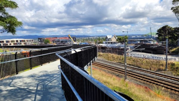
The steel boardwalk near Blockhouse Bay Road
Designing for people
While there will be more to say as the path opens and people use it, the NL2A path is an example of what happens – the good and the bad – when a shared path is designed by engineers. The path works its way through its various contexts to meet its end goals, and the bridges are designed to fit with precision, but it does feel like there hasn’t been much thought to how a person may experience the journey. The odd unsafe crossing, narrow and encaged section, and wrong-way chair are small things, but they’re the difference between designing for people and engineering for structural performance.
These shared paths give Aucklanders a way to travel that’s low carbon, good for physical health and mental wellbeing. NL2A will be well used and well loved but those missing details will make this beautiful, expensive path feel like a compromise.
When AT have finished building the path, it’s the Local Board who are going to be held responsible for any flaws. If those elected could have had more of a say on these little details along the way, we might have been able to circumvent issues that now seem obvious.
That gripe aside, it’s an all-round win for the community, AT, and the people who are going to benefit every day from having a safe alternative to car dependency, and the option of adding emission free travel to their transport choices.

The NL2A path is expected to open sometime in June 2022, although exact timing is yet to be confirmed.
To get on the mailing list for the Dempesy Wood updates, use the contacts below:
If you have any questions or queries, please contact our team on free phone 0800 285 463 (24 hour number) or email us at NL2A@dempseywood.co.nz.
For general AT or project enquiries, email projects@at.govt.nz or phone 09 355 3553.

 Processing...
Rename this project Opportunity cost. The $47 million dollars for 2.9km of shared paths that has multiple interactions with roads and is set to make Avondale station the danger zone. It’s going to be a year late but zero meters of feeder network have been suggest let alone built (don’t at me about the mayors thing) and this project is was used by AT as an excuse to not build infrastructure on Ash Rata (people will still use Ash Rata).
Instead at $500,000 per km this money could have been 100 km of protected on road bike paths. That would be actually transformational.
This is a road protection project.
“This is a road protection project.” Yep.
And at $ 20 m / km it’s another data point showing just how is expensive cycling infrastructure is. The Herald columnists and their readers will love it.
GI-TD Stage 2 will open soon at even more $ / km. (And like NL2A there’s no provision for safe cycling on any of the local streets that it connects to).
Te Whau has got to the be the king of these projects. 35 million “shovel ready” 2020 project, 1.9 km of path, for that we get a bridge acorss the Whau river and bit of shared path that already covered by on road bike paths in Te Atatu south.
Meanwhile, townhouses and apartments are being built along west coast road and great north road, but there is no funding for the planned on road bike infrastructure…
If you are worried about opportunity cost you should focus on traffic projects or the light rail tunnel that are literally one hundred times more expensive per km.
For the price of that rail line they could have built this thing three hundred times over.
Oh I am concerned about them. The core issue is the same tho, the powers that be refuse to reallocate any land, so Auckland bike lanes cost what light rail does in Europe and our light rail i/ more expensive than maglevs.
Fair enough, it is caused by the same problem. Hand wringing over kerbside parking means we get off-street cycle-mini-motorways along rail lines two blocks away from the main street, and tram lines drilled in tunnels under the road instead of on them.
100% true. A way to chew up the budget for very little benefit and avoid any controversy or difficult decisions.
Honestly AT should have just whacked a bunch of concrete Tim Tams along Rosebank Road and Great North Road. Would have been way better outcome, would have cost maybe $1-2m instead of nearly $50m, and could have been completed in weeks rather than years.
So much effort for a pretty “meh” result. This cannot be the model going forward.
They could do this on every major road by just taking out the pointless painted median, we could have a protected cycle network in the entire city within 6 months with the tim tams and some repainting of road markings. But the median is holy, it must be preserved
100%
For a particularly egregious example, I give you Green Lane West.
All of East Coast Rd from Glenvar to Greville Reserve and then down Forrest Hill Rd. Goes past several of the largest schools in the country and large employment areas. Has some shared paths, has some unprotected on road paths. Nothing through any intersection. Painted median must be maintained because… turning cars?
Also, nothing to connect to the small length of cycleway beside the motorway between Oteha and Constellation as part of motorway works.
This is also one of my pet peeves
Fantastic, expensive, active mode bridge across the motorway? Check out the lovely ‘Tirohanga Whānui’ bridge between Spencer Road and Don McKinnon drive in Albany.
Of course checking it out would involve finding it; there is no signage or suggestion of any cycle infrastructure from East Coast bays or Albany side.
The path just stops and starts with no connection; I had to work out a weekend cycle on Google maps to figure a ride from home to the Torpedo7 shop in Albany. (I also had to request a bike rack get put in place at T7 – a bike shop among other things that didn’t encourage people to cycle to/from there).
I came pretty close to serious injury riding through a roundabout in Spencer Road; a large SUV came through at speed while I was trying to cycle through.
Same issue with the other excellent Rook place cycle way under the Upper Harbour Highway
totally agree. Ideally they would have done both though
Lovely post thanks, Jessica. Good to know some of the details.
Paying extra for the flyover up at Blockhouse Bay Road end because stakeholders couldn’t resolve their differences is money that could have been used elsewhere. Do you know if the problem has been elevated to anyone who would try to resolve it now so it doesn’t happen again? Not that I can think of any person who’d ever take action…
I agree, why didn’t we/AT approach this one property on Blockhouse Bay Road to use (an upgraded) existing driveway for the cycleway – save all the money on not needing that new bridge!!
https://imgur.com/a/czPftbi
https://imgur.com/a/0JCuaM6
That driveway goes to a KiwiRail office/site. I imagine they are one of the stakeholders Jessica referred to.
Hope there’s some decent lighting going in.
Thanks for the article Jessica. This is a really useful link because it extends an existing path and makes new connections that previously didn’t exist. The Whau Creek bridge and St Georges Road to Chalmers Reserve underpass are two of the most helpful. These do cost money. You can’t create new connections like these with tim-tams.
The next step should be to densify the cycling grid in and around Avondale. The St Georges Road two-way section is great…but then it gives up the ghost at Porowhita Road. Anyone seeking to cycle into Avondale centre is dumped back on the road without protection and at the mercy of angry drivers itching to make it to Avondale roundabout five seconds earlier.
St Georges Road needs to have a two-way cycleway all the way from Avondale Roundabout to Wolverton St. Now this is the kind of thing that you can do with tim-tams.
As someone who gets around on bike and foot, and lives locally, I am very saddened by the outcome of this path. The underpass in particular is a genuinely frightening experience for walkers – awful entrapment between fences, very poor visibility, and very unappealing.
George – this is not $ well-spent and I don’t know how it was possible that this underpass avoided a CPTED (crime prevention) review.
Matt B – The rest of the path is physically unsafe, inefficient, and very unappealing. There were so many on-road options that would have had better outcomes.
Clearly kiwirail didn’t want to come to the party and share their access at Blockhouse Bay Road and so they cost our cycle infrastructure millions of dollars as a result – who are these obstructive people working in silos.
AT, get yourself some decent designers (not just engineers)… people with a perspective that extends outside the planned corridor, and a broad mandate for outcomes… and have some challenging design review (including locals), otherwise you are creating giant expensive liabilities.
It would have been better not to build this at all and I’ll be returning to footpaths on the roads for walking the kids.
Great post Jessica.
Pretty amazing how much money and time gone into 2.9km shared path.
Why in NZ this kind of project take so long and cost so much money compared to a similar project in other country which take far less time and money. Do anyone know why?
Part of the reason is that all existing road corridors in NZ are narrow.
Where I currently reside the design standard for corridors is wider and easily allows for protected off road pedestrian & cycle facilities.
NZ needs a new nationwide vision zero/ carbon zero roading design standard for new infrastructure that provides sufficient space for all modes.
The housing density can easily be increased if required to offset the wider corridors.
Narrow? Do you get out of NZ much? Our roadways are incredibly wide when compared with to all of Europe (Ireland, Russia, Italy, UK, Slovenia etc take your pick).
Comming home after the “great lock out”, it’s been disappointing to see how little the country has taken advantage of its wide roadways during Covid when compared to Europe and North America who have been very transformational with their multimodal use of far narrower roads.
“When I enquired about this lack of consistency I was advised that the crossings were out of scope for the path project. It’s another department’s problem. ”
Really, but what’s a couple of intimidating crossings between friends. This crap takes out potential users,who either lack the confidence to engage with traffic,or are held back by responsible caregivers. If this was a road,would it be acceptable, does it align with Vision Zero?
OMG looking forward to ditching the car.
10 years of waiting for this one.
Pretty negative views from most people. At least something has been built. Hope it opens soon as its on my way home and avoids loads of busy roads.
I got doored in 2020 biking from Wolverton street from the Waterview path. I was on board with this project. Then AT suggested zero feeder network as it was being built and used this path as a reason to not build bike infrastructure on Ash Rata.
That’s great you benefit from this path. Given it’s between two commercial areas, many don’t.
Thanks Jessica, great profile and background. I was supporting the local board when this project was in dream, concept, securing funding and first design phases. It was 10 years ago, a different world and whilst one or two AT staff were interested it was also the visionary assessment by Waitakere City for a rail route that runs from Swanson and the the local board’s belief and allocation of funding that got this moving in the early days. Waitakere Ranges Local Board is working to get the Henderson to Glen Eden connection improved along with some feeder connections but it isnt easy retrofitting. The active modes world has moved on and its great to hear the push for road space for active modes more. The NL2A will be a great addition but if the network is to be progressed we need to vote the right people in onto the top table, like you. Lets do it!
Mark, I agree with the Henderson to Glen Eden connection, but what about from New Lynn to Glen Eden? Do you know if there’s been any progress on this or what the plan is to extend NL2A further west?
I asked my local board member about New Lynn to Glen Eden, no plans it’s too hard. Oh and it sounds like the connection from Glen Eden to Henderson will be using the cemetery, which already fine to bike on.
ATs plan to conect New Lynn to Henderson, involves Te Whau path being given the better part of a hundred million and people biking via Glendene.
I really do want us to start putting a better network of feeder routes and protected cycle lanes everywhere. But do remember Te Whau is not an AT project but one started by people wanting to improve the awa, got backing from a forward thinking council ( Waitakere City) and has received funding from Government not AT.
Like Avondale to New Lynn, it’s central money, yea I know.
My local board member who is trying to figure out a from Glen Eden to Henderson on shoestring budget, is also on Te Whau board. When things like this happening it’s a tad frustrating.
Good to see this project nearing the end. Now more reason to build some feeder networks to it.
Great article, it’s good to hear views from the local board. However, I don’t think it’s fair to describe this as what happens when engineers design a path. This is what happens when people who don’t use paths like this design paths like this.
“When I enquired about this lack of consistency I was advised that the crossings were out of scope for the path project. It’s another department’s problem.” This is not the first time that excuse is being used. And yes, this is coming from the top, where the organization is set up to deliver projects within their project scope and those project definitions do not include any of the official strategy documents (e.g. around parking or vision zero or mode shift or whatever other useless strategy paper is being written (useless in the sense, that it does not impact BAU)).
I don’t necessarily think this is an issue with the engineers, because if you give them the task to come up with a best practise solution they perhaps could (having said that, NZ engineers within our government institutions probably have been trained to be car-first and evidence-averse and might have been also trained to not think for themselves).
Its funny when you see other cities committing $100mil to cycling and completely transforming the city. We spend $50mil on 3km.
Don’t get me wrong, these shared paths are great to make the neighbourhood much nicer, and I do think they should keep building them (probably pick projects that are a bit cheaper than this). But if they really want to tackle climate change and people cycling, blowing all your budget on 3km isn’t going to do much.
It’s a real shame that the rail cycle path promoted by Waitakere CC didn’t get enough credit when the New Lynn rail trench was being designed and constructed. Some of the nasty bits are through trying to squeeze between the trench and the property boundaries (Shawshank). Will this need street artist work to brighten it up? However, that rail project was a long time ago (in design standards). Completion of the path should elevate the importance of dealing with feeder links and the unsatisfactory crossings. What was ‘standard treatment’ back when the project was being designed and consented wouldn’t be standard now and could well lead to improvements following up on this. And designing alongside Kainga Ora isn’t always easy. Just try designing where two or three independent projects are being prepared at the same time – each client has already fixed their ideas before collaboration can start. The little bit of St Georges Rd cycle path, from rail crossing to the Kainga Ora site was incredibly difficult, with trees to protect, berm slopes to manage and vehicle crossings to keep. No reason it couldn’t be continued north, given some funding.
Anyone who thinks its ‘easy’ to drop in a few separators and get protected lanes should try designing them. Getting rid of flush medians can sometimes help – not always.
But this is a really good post, celebrating what has been achieved and rightly pointing out some things that should be improved in the future.
“Anyone who thinks its ‘easy’ to drop in a few separators and get protected lanes should try designing them. Getting rid of flush medians can sometimes help – not always.”
I’ve done this professionally. It is so much easier than our institutions make it seem. You just have to accept narrow lanes (for vehicles and cycles) at tighter spots, reduce traffic lanes where necessary, and consider one ways on lower volume streets. We have very, very few roads with <10m of seal and you can easily get separated lanes in that width if you prioritise it.
“But on the other hand, there is a visually indistinguishable raised table on Chalmers St.”
How did this pass road safety audit?
Surely it requires reflective triangles on the approach ramps and ideally a painted crossing on top.
Legally, you don’t have to do either. But if you are going to build a crossing to look like a continuous path, you really should give active road users priority. These ‘courtesy crossings’, where priority is made intentionally unclear, are a ticking time bomb.
It could be worse. There are several otherwise decent cycleway’s near me in which there is no attempt a crossing at all:
[Spencer road to Alabny cycleway](https://goo.gl/maps/EAy6V76kqZKyCTkX7)
If you look a that, it has lighting, nice wide shared path, bollards, painted direction signs etc. Nice.
But it just ends. No hints at all that the cycleway continues across the road. The first time I missed that there was another cycleway as there was a small truck parked at the end and long grass in the reserve, so didn’t spot the connection across the road:
[other side of the road](https://goo.gl/maps/mJabeRHztFNAUNpQA)
That one is really bad. Definitely a case on NZTA (as they were at the time) deciding that their scope was to get to the nearest road to satisfy the consent conditions, onwards journeys be damned.
I often walk that path and to be honest I didn’t even realise that it’s the cycleway on the other side. I thought it’s just a walking path. And the one that looks like cycleway has a total length of 100 or 200 meters so it’s not extremely useful for bike trips anyway.
A great project is designed by Architects, Calculated by Engineers, and Delivered by project managers.
If the project is only drive by Engineers, you get design just ticks the box, but not appeal to user, over budgeted and over engineered.
Thanks for the great post Jessica.
I can be as cynical as anyone, but I’m really happy about this project, it’s (almost) changed my life. I recently started a job in the CBD, so invested in an e-bike and am commuting on it every day. Before I wouldn’t dream of cycling in from my home in Titirangi – too far and hilly and the roads are too dangerous for me. Now thanks to this project and the advent of e-bikes its a possibilty. It’s brilliant – except travelling on the roads between Titirangi and Avondale, which fortunately won’t be for long.
Plus at the weekends my kids and I will be able to ride about 1km to West Lynn Road and we’re on the shared path – instead of driving to find a safe place to ride.
I know people say hardly anyone uses these paths to commute(compared to roads) but that’ll change over time now people have an option rather than sitting in traffic getting no exercise (I do understand a lot of people need to travel by car for lots of reasons). Once I hit the Northwest path into the city there are HEAPS of cyclists, which is great. The paths I ride are very popular at weekends too for all sorts of people wanting some exercise.
I also understand people saying “we should just stick Tim-tams by the road” but that’s still a pretty nasty, noisy, polluted way to travel by bike, so won’t convert many people. I realise this project has cost us a lot of money, but it’s been done properly, rather than yet another Auckland “bodge”, and it’s there for good,
According to the very nice)lady at AT who answered my email query on 15th March: “We are still on track for overall completion this month (Covid and weather dependent). An official opening ceremony is planned for the end of April when the path will be open to the public.” Would be nice but let’s see….
Er, no, predictably it’s still not finished. According to the AT lady this is due to COVID and rainfall. I don’t have the energy to tell her there’s been very little COVID in Auckland in the last month, and only 12mm of rain. I won’t mention the new quoted timeline as this will only make me look twice as gullible.
So completion at the end of April is only the third lie I’ve been told then is it? For the cost and delay there shouldn’t be anything wrong with it and I guess we can hold the people who said “not my dept” responsible if someone gets hit on one of the poorer crossings.
Hi i am looking forward to the opening and would love to be there if you could let me know when it is decided Thanks The EELS Man Paul :”: :”:
Here is a view fro the Train from Mt Albert to New Lynn ;-
https://www.youtube.com/watch?v=gsW4N7ZWu0I
Good video – I can see a lot of work has gone into its editing. Gives a better perspective to me about the amount of work that’s gone into the path too.