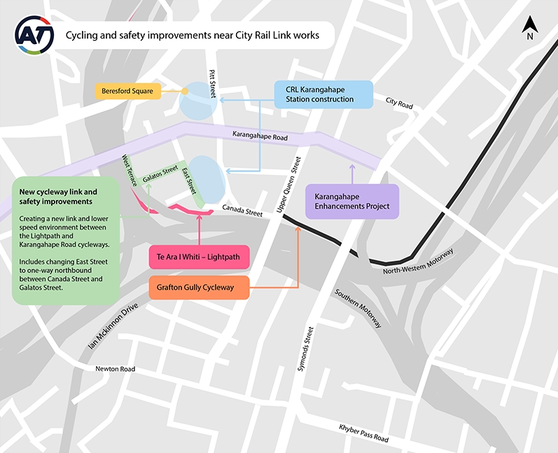
Construction of the City Rail Link is now in full swing and that means lots of truck movements in the area. As an unexpected but positive surprise, Auckland Transport are proposing a new safe cycling link to connect Karangahape Rd with Te Ara I Whiti – Lightpath via East St, at least until the station construction has been completed.
Changes to the streets surrounding the CRL Karangahape Station site are needed to provide a safer environment for cyclists, pedestrians and other road users during its construction. Heavy truck movements to the CRL construction site are expected to continue over the coming years. Upon completion of the Karangahape Road cycleway (early 2021) we expect more cyclists and pedestrians to be seeking a safe connection between the Te Ara I Whiti – Lightpath and Karangahape Road. To provide these users with a safe connection, we are implementing a range of improvements:
- East Street to become one-way northbound between Canada and Galatos Streets, to prevent conflicts between south/eastbound vehicles and trucks entering the CRL site. Vehicle access to Canada Street will be via Upper Queen Street and Mercury Lane only.
- A new two-way, protected cycleway along East Street between Canada and Galatos Streets.
- Road surface changes in the form of shared lane markings (sharrows) along Galatos Street and West Terrace to indicate a slow speed environment for all road users.
- To assist with wayfinding, the colour scheme for the cycleway and slow speed areas will match that of Te Ara I Whiti – Lightpath i.e. use of the colour pink.
- Proposed removal of 19 car parking spaces within the project area include:
- Six on Canada Street – were made inactive as part of early traffic management for CRL station works
- Six on East Street – to enable the two-way cycleway
- Four on Galatos Street – to give cyclists space and a clear line of sight when moving between this street and West Street
- Three on West Terrace – to give cyclists space and a clear line of sight when moving between this street and Galatos Street
- New speed humps on East Street to create a slower-speed environment around the CRL works site.
- Relocating the Galatos Street loading zone to the opposite side of the road to provide clearer line of sight for cyclists and pedestrians.
I’m not sure why they didn’t include the Ian McKinnon Dr and Upper Queen St cycleways
It’s good to see AT being proactive and pushing quick wins like this to improve safety. I just wish they’d do it more often.
A bit more detail on the proposal is shown in the images below. West Terrace and Galatos St are both very quite so just riding on the street is not a major issue. The only thing I do wonder about is why they haven’t just kept East St one way all the way up to Karangahape Rd. There doesn’t seem to be any need for that short southbound lane.


The West Terrace to Galatos St links is a handy little connection and came about as a leftover from when the motorway was ploughed through the area. West Terrace itself used to run to Upper Queen St – what is now West St.
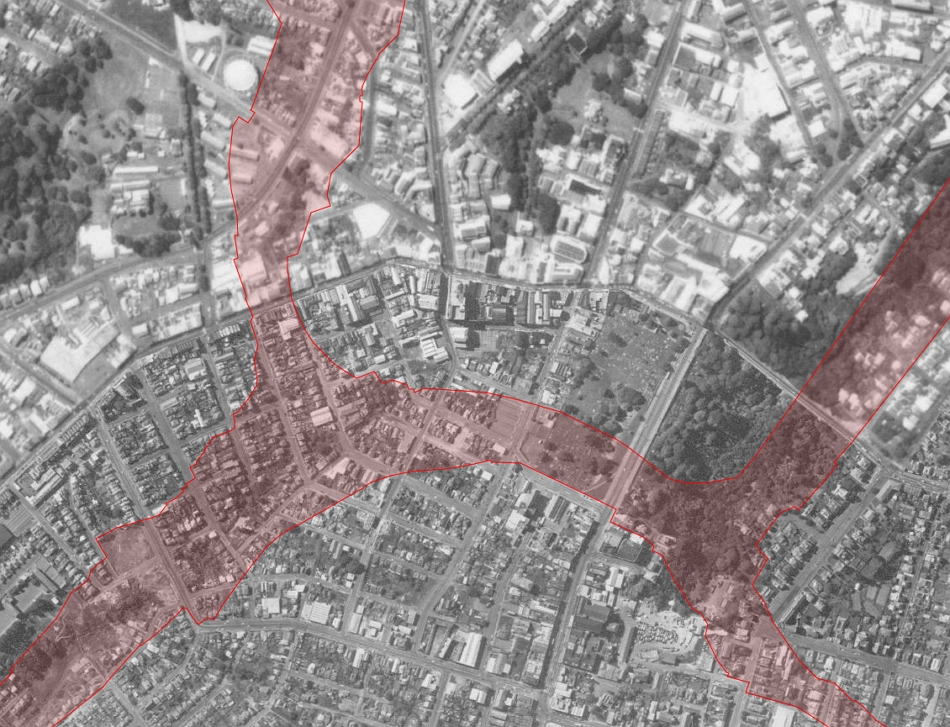
The area around K Rd in 1959. The red outlines the current motorway corridor boundaries
Consultation on this is open till Wednesday 4 November and AT say if approved, the changes are expected to be installed by the end of the year.
AT should be rolling out changes like this all over the city but especially near schools to make it safer and easier for kids to ride to school.
While we’re here, don’t forget about the other consultations currently open.
Northwest – Closes Sunday 25 October
One of the government’s covid response shovel ready projects is to make improvements to buses on the Northwestern. AT are currently consulting on those plans which primarily consists of a bus station at Westgate and some bus stops on motorway on/off-ramps at Lincoln Rd and Te Atatu Rd. I wrote about it here.

St Heliers Village – Closes Monday 2 November
AT originally had a proposal in St Heliers to better protect people, a new one is now out for consultation that focuses on just protecting parking spaces. I wrote about this here.

SH20B Speeds and Transit Lanes – Closes Wednesday 4 November
Waka Kotahi NZTA are now formally consulting on plans to lower the speed limits on SH20B from SH20 through to the Airport. They’re also asking about the new lanes they’re adding being T3 lanes. The use of T3 lanes is better than nothing but is all about appeasing the traffic model and will mean buses will get held up when trying to merge back to the two-lane Pukaki Creek Bridge. These should be bus only lanes.


 Processing...
This cycle lane is described as temporary – just for the construction period. However considering the additional pedestrians and cyclists that’ll be using the area after the station opens it really should be permanent.
I’m not seeing the purpose of this new route over cycle lanes on Upper Queen, K’Rd and Pitt.
I do like to hear the council describing “clear line of sight” thou. This thinking has been clearly absent on many recent cycle routes, e.g. Waterview
The purpose is to allow the hundreds of residents and employees in the area between the motorway and K Road safe access.
The aerial photo with the CMJ as a red overlay is a good image. Remember that planning numpty who wrote a paper claiming the Central motorway junction displaced 50,000 people? They must have been living 1000 people per house in those 50 houses.
It doesn’t compute.
Assuming they were referring to the whole of the central motorways and adjacent clearances, that’s around 100 hectares (a million m2) demolished across Freemans Bay, Newton, Arch Hill, Eden Terrace, Grafton Gully, Grafton and Newmarket.
Indeed a massive amount of demolition, but accounting for streets and other non-housing spaces, it would have meant the average dwelling was sitting on about 50m2 of land. Unless the were knocking down block after block of apartment towers that doesn’t add up.
More likely is a misreporting, 15,000 *people* displaced from say 3,000 homes makes more sense. It was described as a crowded slum, so an average of five people per dwelling sitting on 350m2 of land each stacks up.
Can’t find a source for the 45,000/50,000 which I’ve seen quoted, but this article presents a nuanced history of central city population through last century.
Figure 3 shows the plummeting populations in the CBD, Freemans Bay, Newton, concurrent with the motorway clearances but not entirely attributable to demolished houses.
It is one of those bullshit statistics where people can’t quote a source they just quote the last person to make the claim. https://web.archive.org/web/20140728091540/http://www.nzgeographic.co.nz/archives/issue-127/kroad
or https://www.nzherald.co.nz/business/four-level-property-has-plenty-of-options/UTV76R63454G44IRGADPDC6ULY/
It is like that bullshit some educators claim that most of the jobs that kids will do haven’t been invented yet.
According to the K Road Business Association, it was over 15,000 houses, not 50 houses, and over 45,000 people, so 3 people per house.
http://www.kroad.com/manage/resources/1st-brochure-1.pdf
So if it is around 50ha (some was cemetery and some was road) that is 0.5sqkm. 45,000 people gives a population density of 90,000per sqm or about double what Dhaka in Bangladesh has. I am calling bullshit.
Someone somewhere has conflated a decline in population (due to smaller households, fewer houses due to land use changes in a growing city centre) with the impact of a motorway construction site. It is the Post hoc ergo propter hoc fallacy.
There’s only a very small gap between the end of South St and the Lightpath. A connection here onto the Lightpath could be very useful and reasonably cheap/easy??
A quick look at street view shows it wouldn’t be quick or easy as Lightpath is still an elevated path at that point. It is such a short distance to where it joins onto East Street that I don’t think it would be worth the money it would cost.
I a ometimes wonder about the feasibility of a link the other direction, from the pink path near South Street over the motorway to Ian McKinnon near the park cycleway. It would eliminate around 700m distance and the hill/elevation changes. Technically a bit more challenging to integrate but would get a heap more use than the other motorway bridges they build out by Westgate etc.
They probably want to keep the southbound traffic lane at the top of East St to allow access to the construction site?
This cycling link is a good little project, nice to see.
As for the Northwest Bus improvements, I was going to provide feedback but then didn’t bother because what on earth could you say about it that would just either be out of the project scope or budget? I guess I should of just to counter any “don’t build it at all” feedback.
Seems crazy that the entire length of East St was not simply made one way?!
Only going to encourage delivery trucks to use that route into Galatos St when not necessary.