There is increasing discussion about the moving the Ports of Auckland to Northland with the latest report on it being shared with cabinet ministers.
Cabinet ministers now have a copy of a report urging the government to move the Auckland port up north, but say no final decisions have been made.
A feasibility study on creating “Northport” was commissioned, after New Zealand First struck a coalition deal with Labour.
It would be a huge infrastructure project if it goes ahead, with a price tag of about $10 billion.
There would be roading upgrades, a new 18km rail line to connect Northport to the main trunk line between Auckland and Northland, and a new freight distribution terminal.
A working group has delivered its report, which has found freight operation in Auckland is “no longer viable”, economically or environmentally, and recommends Northport go ahead.
This report follows an interim report released last month on the issue and looked at five options for shifting the port which are full or partial moves to Northport or Tauranga as well as to both of them.
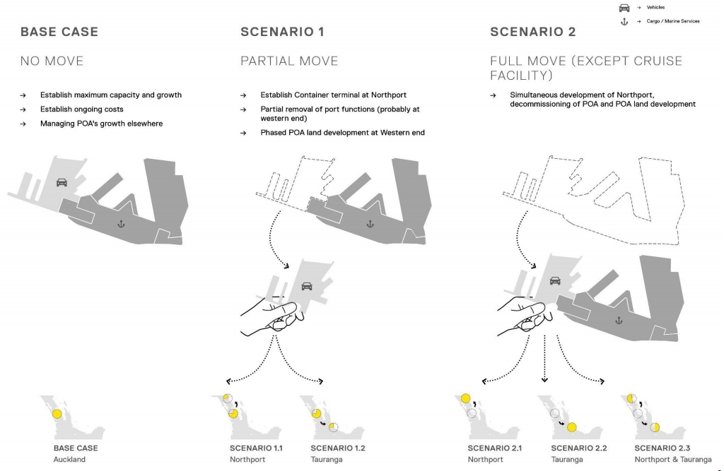
The economic case for a full move to Northport was favoured over the other options based on this BCR relative to the base case of leaving the port where it is.
Of course this isn’t the first time there’s been a report looking at moving the port with the last one happening in just 2016 – the Port Future Study. That report recommended further investigation into options at sites in the Firth of Thames and the Manukau Harbour. As part of that investigation it looked a large number of sites including Northport but discounted it, saying:
Long term demand growth is likely to exceed the expected capacity growth available at the Port of Tauranga and at Northport
It is interesting that these two reports so close together could come out with such different outcomes.
And indication of much Northport would have to expand to accommodate Ports of Auckland shifting there
There is going to be plenty of debate in many spheres about the port and I suspect there’s still a lot of water to go under the bridge as to whether it moves or not. For one thing, $10 billion as suggested is needed to implement it, is a huge amount of money and such a move is likely a multi-decade investment so would likely need cross-party support.
So with this post I wanted to consider some of the more Auckland centric opportunities
Council Finances
The Auckland Council own the Ports and get dividends from it but that dividend can be highly variable. Last year it was $51.1 million but that is projected to be just $8.7m in 2020 and $9.4m in 2021 before jumping up to $64.3m in 2022.
The current study suggests the following with under the full move the ports still having an income from cruise ships and their other holdings. But it suggests that the council could be able to collect more rates as well as leasehold income from the freed up land which would see it get better overall returns.
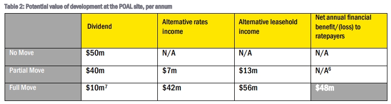
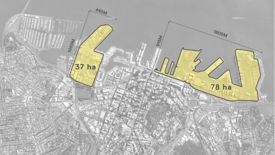
The challenge is that is a significant proportion of land, making up 18% of all the land in the central city and so developing it is that proverbial “how do you eat an elephant” question. The issue is that it would take quite some time for development to come on stream and there would need to be significant capital outlays to enable it so in the interim that is money the council would needs to make up from other sources.
For an example of size, Wynyard Quarter from Fanshawe St to the tip of Tank Farm is less than half the size of the remaining port land and has been under construction for a decade with still lots to go. There was also many years of planning before that. Presumably it would be more of a managed withdrawal though which might help negate the impacts a little bit.
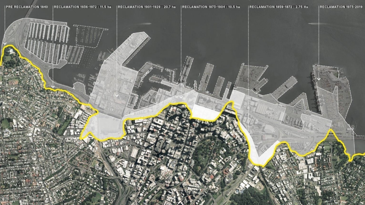
 One thing that’s semi-related but interesting is how we got to have that land. The map below shows how the waterfront was reclaimed since 1840.
Development options
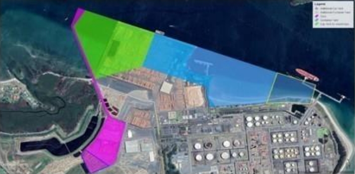
If the port did move we can likely expect similar outcomes to what we’re seeing with Wynyard Quarter and the image below shows a potential outcome from a masterplan the study has undertaken. It includes declaiming some of the land and accommodating.
- 20,150 more hotel rooms
- 58,000 households
- 75,850 jobs
- more retail, entertainment and cultural areas
Note: these numbers seem way too high given the development we’re seeing at Wynyard.
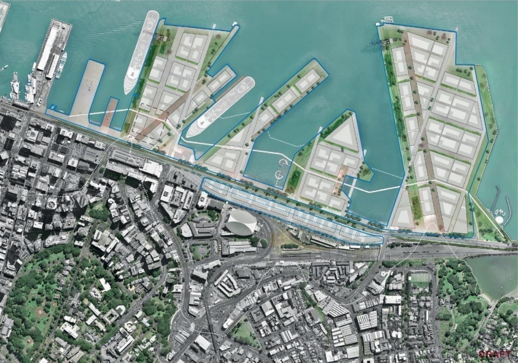
If we’re going to be developing all of this land, we’re probably going to also want a new train station on the Eastern Line somewhere around The Strand.
Of course this isn’t the only part of the central city that could be opened up for development with right next door, Quay Park and up Grafton Gully also being proposed in the City Centre Masterplan. Which leads us to …
Grafton Gully opportunities
As we’ve talked about before, one of the major new additions to the City Centre Masterplan refresh is looking at Grafton Gully with a proposal for a multiway boulevard and a decent part of that is about accommodating trucks getting to and from the port. However it also opens up an additional 26 hectares of potential development space. If the port was to move that may allow us to implement that project differently.

The Transport Networks
With the port gone the Eastern Line at least would largely just become used by just metro and intercity services but there could be some major implications for the Western Line.
Currently there are only a few services a day on the Western Line but that will likely change in the future with the government already investing with Kiwirail to upgrade some tracks between Auckland and Northland. But the thing to think about is that after the CRL opens in 2024, the western and southern lines are likely to be too busy with metro services to have capacity. As such the report talks about an inland port in the Northwest from which these freight services would either need to travel through Auckland at night or we’d need a 3rd main on the Western Line too – although quite how you’d get that through New Lynn a challenge.
Just sending the trains through at night is the most likely scenario as that avoids the need for need for additional infrastructure. However if we did manage to build a 3rd main though West Auckland, which is unlikely to be very cheap, then it could also potentially see the building of the Avondale Southdown line – although given the development that has occurred nearby the line since it was originally proposed I suspect it could end up being challenged by nearby owners. Perhaps instead we’ll end up needing something like Patrick suggested in this post.
There are also questions about what impact the upgrading of the lines have on the ability to provide services west of Swanson. Perhaps once we get Hamilton services up and running we might see calls for intercity services to Whangarei too but I’m still not sure we’ll see regular commuter services as the issue remains that the rail line travels out of the way.
In some ways the push for using Northport by some also feels like a bit of a Trojan horse to getting an otherwise unjustifiable motorway extension over the line. While the goal is to get most of the port business on to rail, it would still see large numbers of trucks plying SH1 towards Auckland. I wonder what impact that will have once they hit the congestion in the city and if that increases calls for other projects like an additional harbour crossing.
As mentioned it still feels like there’s a lot of water to flow under the bridge but one aspect that is concerning is that Auckland seems to be largely being left out of the discussion. Before any decisions are made it feels like a lot more work needs to happen to understand the impacts and collaboratively come up with a solution.

 Processing...
Can anyone say Conflict of Interest with Wayne Brown having the reports written for the anti urban and anti Auckland Shane Jones?
Simply put you dont add an extra 170km of distance to logistics without incurring serious costs especially as West Auckland has no heavy industrial base and is not suited for one the size of Southdown and Wiri either.
Northport would be best invested in Primary Industries Exports and let Auckland handle the imports given market locations
West Auckland is also paralysed with traffic and money spent on this Republican-style boondogglery would be money not spent on resolving the traffic there.
But sure, let’s put a freight hub for the *entire region* there. Can’t see any lost efficiencies there at all.
Part of me could not care less of this never happened precisely because Shane Jones has been anything but a pointless self-imposed, self-centred dickhead who likes nothing more than giving the middle finger to Labour and most especially the Prime Minister. Not to mention the many dead rats Labour have had to swallow on behalf of NZ First considering their tiny percentage of the vote.
Are you now going to be a prize cock now Shane???
Perhaps they could steal our hospitals next and we could all drive up there or ride in a giant ambulance bus. I am sure that would be great for the Northland economy too.
Moving Aucklands seaport to Whangarei makes about as much sense as moving Aucklands airport to Whangarei.
Ha ha ha.
First, the ambulance bus. It most definitely must remain a bus, not a rail carriage. As a bus it can pick up casualties on the road all the way up to Whangarei.
Second, moving the airport to Whangarei. Hmmm… should we analyse whether the effect of putting people off flying would have a bigger emissions benefit than the effect of them driving to Whangarei to fly? Chuckle. And can I pay EY to do the report for me? 🙂
For those of you that never saw the Q+A piece Monday night here it is and in the last 2 1/2 mins he is asked what his credentials are and replies to what I think is honestly ;-
https://www.youtube.com/watch?v=Bb92Dn9Xf0s
Wayne Brown is right about the poor returns. But that is the fault of the people who bought back the entire port company into public ownership and the because of its location. Before the port company directors had to make a return, now their goal is to minimise hassle to themselves. They are doing that by eliminating as many jobs as the possibly can regardless of how much it costs to get rid of each employee. The result is high spending on automation and very low dividends to the public owner.
One thing I can’t help noticing is how much this Wayne Brown says “um” all the time. How can he not rattle off his answers with ease and articulation?
Agree with Ben. This is too much an all or nothing recommendation. There would be a number good good outcomes in some areas but it’s a ridiculous distance to cart the majority of goods to or from.
Ships are the most efficient at moving this amount of goods, want them as close as possible to the main centre(s) as we can.
I’m think with some relocation to Northport, Tauranga. I also am reasonable optimistic that increased efficiencies particularly at Auckland with space reductions & automation we maybe OK for a long long time. This would be helped with increased taxes on vehicles & environmental polluters hence reducing vehicle imports. With the popularity of climate change & hopefully with a trend for people buying more quality goods that last it would help a long way in reducing importing so much crap that we just throw out after a short period of time.
Big question is how much population increase we are going to have to off-set these savings. If it’s primarily going to be in a more dense urban environment then people going car (ownership) free by using public transport, active modes & taxi/rental cars when needed could have a huge effect on the space needed at the Auckland port.
Hear hear
Wayne Brown is a former mayar of Kaitaia. He has extensive property holdings and business interests here, in Mangonui, Kerikeri and Whangarei.
An expansion of the port and overflowing economic activity associated with the move will likely benefit him very nicely.
I had a fairly good idea of the reports finding as soon as i heard he was involved in preparing it – and the recommendation that ALKd port moves north came as no surprise.
Wayne Brown also looks like he won’t even be alive anymore by the time a Marsden point port was operational anyway.
https://www.movingaucklandport.com/
maybe there are other options that should be considered solving all of the problems at less cost?
Who came up with the ideas in that webpage – Gyro Gearloose in association with Elon Musk?
Try giving some useful feedback. What don’t you understand?
Useful feedback? Factory reset and start again. I understood the proposal alright, it’s about as ludicrous as building a port at Muriwai. That did make it on to some form of official list i admit….
Nice… thanks so much….
Was this an April fools day thing?
This clown produce costings for North port but there was nothing for any of his other suggestions which problerly would cost a hellav lot more especially if they have to spend years going through the RMA and all the court hearings that will follow .
so you didn’t read it all?
costs for building the terminal would be the same for any other destination. 1-2 Billion.
Costs for the tunnel could be between 1 and 10 Billion, depending on lots of factors. Yes, it need a feasibility study, and yes the RMA would be significant hurdle, however with classification as ‘roads of national significance’ it could be overcome. Or potentially a new Act of Govt.
How on earth did you figure out that building a port ar Northport and double tracking the NAL would be more expensive than building an entire island and then tunneling underwater for 25km?
You’ve said the tunnel could be up to $10b, but you’re basically building Waterview 10 times over, and doing it underwater, too!
You’ve also not shown any breakwaters at that port. I’ve seen 6m waves sailing out there before.
If you want to be remotely credible, then you at least need to propose the island to be just off of Miranda and Kaiaua where the sea drops off relatively fast, you are relatively close to the NIMT, and you could connect with a short causeway.
The numbers for moving it to NorthPort has been estimated at 10.3 B. Those are not my numbers.
Why do you think building new stacking space and berth at NorthPort would be cheaper than anywhere else? how do you get 3-5km of berth at NorthPort?
Cut and Cover, Dredge and submerge is much cheaper than boring, dredge and submerge has been done for $40M per kilometer, and the water is very shallow over the entire distance. If that was the cost it would come in under 1 Billion (the same cost as moving the cargo to and from Auckland each year, again, not my numbers)
You don’t need to have a breakwater, you turn the terminal around to face inland, just like many other international terminals have been built, none of what I’ve suggested hasn’t been done before.
And your suggestion of Kiaua needs 40-50 km of tunnels and road network through the Hinua ranges….
“Cut and Cover, Dredge and submerge is much cheaper than boring, dredge and submerge has been done for $40M per kilometer”
No, it hasn’t. No one anywhere has built a road tunnel anywhen in the last 50 years on any terrain for this price. Please name your source for that price.
Kaiaua would need 27km of at grade motorway and railway from Pokeno. We are currently building a similar motorway for under $30m per km. https://www.nzta.govt.nz/projects/waikato-expressway/hamilton/
You don’t build it here, clearly NZ cant build this kind of infrastructure, costs are too great. We just do the dredging and submerge the pre-built off shore cast segments in position.
So no source on this radical new tunnel technique then?
Another issue with the “just run heaps of freight trains at night” approach is that Kiwirail will need to use that time to maintain the rail network properly. Cities with metro rail networks use every hour of night time closures previously.
Preciously*, darn auto correct.
This is a very good point. Post-CRL the network will also need more maintenance due to the increased number of trains running.
Also, freight is going to very heavy & will really batter the lines, noiser too (though suburbs) I presume even if electrified.
So what? Eastern and Southern lines cope with a lot of freight just fine. They also keep freight flowing well enough even while passenger services are suspended for maintenance. Track renewals are done to two and three levels higher standard than is required for the rolling stock at full capacity with a view to future growth already. None of what is proposed is any different to what already occurs in the southern half of the city.
I agree with Jguize.
There’s already a considerable amount of rail freight movements through Auckland’s existing network and everybody along the line lives with the noise.
The Southdown-Avondale link will mostly cut through either industrial area or run alongside the Southwestern motorway (itself a generator of noise).
There are regular freight movements all over New Zealand’s rail network. They used to be frequent along the Hutt Valley line. People always lived with the noise.
I suppose we would just have more rail replacements buses during the weekends. Actually they work out pretty good now that AT has finally got its act together and got the buses up on to the displays. Certainly at Papatoetoe and Middlemore this is the case. Another thing notice when they do shut the passenger network or parts of the network that the freight trains still roll through on the other line to which they are working. This is why they have the bi directional signalling. So I expect that some maintenance would be done at night with freight trains running on the other track and there would be an increase in weekend work with rail bus replacement. Back in the day there were sections of triple line on the western line Avondale and Henderson if I remember rightly. Of course the line was only single track then. As it is a large number of freight trains can run on the Southern line so why not the Western.
No one is going to put anything valuable or time critical on a train though are they? Rail means surrendering control of your goods. To be realistic the Northport option needs to include the capital cost and running cost of thousands of extra trucks. It will certainly increase employment though. I see it as a kind of Auckland tax.
The majority of containers from Port of Tauranga to Auckland travel by rail. The trains are contracted by PoT and most customers prefer a pick-up from Metroport in Penrose than running a truck for pick up from Tauranga.
There are a number of trains a day, anything that is still too time critical for this is probably coming by air anyway. I would expect a similar arrangement if PoA moved to Marsden Point.
There’s no separating this from the political side of things. This is a $10b swindle, buying NZ First a seat for life in Northland, with no practical thought given to the massive introduced supply chain vulnerabilities in the country’s biggest regional economy.
And for what? Aucklanders are meant to ecstatic to contribute 30% of the cost to move this, all for *checks notes* the chance to spend billions more on a waterfront stadium and some leasehold land that, judging from current leasehold arrangements, will be a millstone around the city’s neck? As for more restaurants and bars? Great, more places that will charge $45 for a main and $13 for a beer that Aucklanders can’t afford to go. They’ll have to in order to cover their leases. If the proposal was for an Albert Park or some usable green space that could be event space or used for street races or other opportunities we don’t currently have then I’d be more keen. But swapping an economic anchor for more of the same isn’t a hugely tempting proposition when Aucklanders will be expected to contribute to the cost of kneecapping themselves.
God, I remember the outrage when National promised to upgrade some road bridges up North. Yet when NZ First mount a campaign tantamount to nationalising a locally owned asset away from a local authority for their own ends, no one will call it out for what it is.
It might cost $10b but it wont get them a seat for life. In the late 70’s and early 80’s National wasted a large fortune up there and captured the votes but only for a while. I see your Marsden B and raise you Auckland’s port.
Ah yes, the Marsden B oil-fired power station. Part of Think Big. Completed in 1978 and never used. Dismantled and sold to India in 2012.
I am very much in favour of moving the port but I am still not convinced that north is the correct location – all that rail through Auckland doesn’t make sense unless there is massive investment in the rail network.
This reeks of pork-barrelling politics from Shane Jones and co. I think Mr. Jones would find a home in Tammany Hall for sure.
I’d like to see that massive investment in the rail network, including a programme to get it to the Far North, which is one of NZ’s most deprived areas.
But it would need to have cross party support, and from first glance this report doesn’t seem to offer a politically-neutral evidence-based piece of the puzzle to help with decision-making. Such a pity.
Although Tauranga is viable the East Coast Main Trunk is unable to handle much more without double-tracking. And the Kaimai tunnel is a bottleneck, unfortunately, that is difficult to overcome.
The Kaimai tunnel can handle 96 trains per day, I believe it currently takes 24 a day, there is plenty of room for growth on the ECMT before a second tunnel is needed.
If we are going to be running more than 96 tpd then the business case will be reasonably strong to build a second tunnel.
To me a key part of this debate, is will Ports of Auckland have to move somewhere. My understanding is everyone including the port has said “Yes”. Is so then the only question is where does it go, and start the planning as will take decades.
I also wonder if such a change may also be a trigger to split Kiwirail infrastructure and operations (into LTNZ like roads), and have freight and passenger services retained?
Doing so while possibly not technically reducing costs could allow rail to get the same subsidies as road, and may result in Rail becoming a more economical option for those wanting to move freight. It could also allow for competition from private rail companies, or even encourage current truck companies to expand into rail.
This debate is being ruined by oversimplification. Dividing people along extremes of “don’t change anything” and “move the whole port.” It’s not constructive at all.
The port currently handles a variety of different shipping services that are essentially independent of each other. Container ships, car carriers, bulk carriers etc. all carry completely different loads. Some functions could be relocated, freeing up space for reallocation to higher value uses.
For example the Captain Cook Wharf is mainly (solely?) used by car carriers. If car imports were relocated outside of Auckland then the entire wharf could be freed up for use by cruise ships (allowing Queens Wharf to become the public space it’s meant to be) and/or developed for other purposes.
Yes Yes Yes!! The all or nothing talk will sink any change or progress whatsoever. It’s obviously a case of horses for courses, but these reports have disappointingly gone for the gold plated and high pain options.
+1, we should be looking at ‘what could we move in the next 5 years?’ and ‘how can we allow that without making bigger shifts in the future too hard?’. Then we see where we are. The cars are an obvious one. They aren’t time critical, they can travel on the rail network at night. We would need to widen some tunnels and Kiwirail would need to build some car carriers. They can come to somewhere like Kumeu and then go to trucks for delivery in Auckland or shuttle in to Westfield/Wiri or south of Auckland at night for distribution from there. It’s going to take 40 years to develop housing on that port site. The last thing we want is vacant post-industrial land there.
+1
Agree, although I’d add we don’t have to have all of a particular cargo type going through just one of the ports.
Another option would be to develop Northport’s container handling capacity so that some vessels start calling there, especially those picking up export cargo from Northland.
Sailor Boy – When it was NZR they use to have car carriers , going by the Ad’s they use to play on TV when the Govt of the day deregulated themand before that they just put them on either the flat bed wagons or the old 4 wheeler’s , and in this video at around 7.17min it shows them ;-
https://www.youtube.com/watch?v=lPDELHFMj3c&list=PLfsLs-KBeTyxVxGxV6hOnQv_Nio0YszXS&index=78
They are going to have to build a lot of new wharf at Marsden, Auckland has about 4km of berth, Tauranga has 3km, Marsden Pt has 560m, the largest container vessels visiting NZ today are 350m. At a guess Marsden will need approx 2000m of new wharf, where do they fit that? To one side is mangrove and a reserve, the other side is the oil terminal.
Sailor boy – this is the ad ;-
https://www.youtube.com/watch?v=lPDELHFMj3c
The last of the car carriers only went to the scrap yard five years ago.
JGuize , And who was in power when the last of the car carriers went scrap the lovers of rubber i.e the “Nats” so all their trucking mates could take over the job of transporting the cars .
And you have all these saying it add more to the price of say the cars rubbish . it’s all been factored into the cost already . So if you buy a car now from Auckland and then ship it to Whangarei or further North will they add the shipping to the overall price or has it already been factored in to the normal price ?
My question where do these people get their extra cost from ?
Agree.
Separate case studies should be made for options for each class of cargo, including the walk on type, the cruise passengers.
What a surprise that a report initiated by NZ First would come out with this conclusion.
The is also definitely something dodgy going on when the person who this report is also the person who wrote the last one that said Northland wouldn’t work. He also happens to be one of the people behind trying to privatise the port land in exchange for building a sunken stadium.
Oh for heaven’s sake. I was going to re-read the earlier report and read this one. Now I think I won’t bother. That’s just pathetic.
Er, I can’t see Wayne Brown’s name anywhere on the previous Port study. The only name that appears common is Shane Vuletich. http://www.portfuturestudy.co.nz/members/
The principle of relocation, managed over time, is not disputed between earlier and current reports. Simon Wilson referenced the issues with staying put here https://www.rnz.co.nz/programmes/the-detail/story/2018698066/what-s-happening-with-auckland-s-port If the only matter is where to move port operations to, and what components, then that should be the focus, rather than status quo vs Northport.
Not Wayne Brown, the person from EY who wrote it. EY just like the rest of the big four (Deloitte, KPMG, PWC) are all corrupt and will write whatever the person paying them asks them to write
exactamondo Harry.
Have a look at who wins the EY CIO of the year award, very high chance it’ll come from a company that spends a bunch of money with them (EY).
The whole process is about as straight as a dogs back leg.
“He also happens to be one of the people behind trying to privatise the port land in exchange for building a sunken stadium.”
Wasn’t that sunken stadium thing all just some publicity stunt (like the ANZAC bridge from before 2015)?
Hmm, 0.5 to 3m of sea level rise by the end of the century? How much is it going to cost to ‘protect’ all this investment, or would it go ahead at all?
Given they spend a lot dredging the bottom then it might save them money.
As it stands the entire North Auckland Line will not be able to deal with this port. Single line, winding, hilly in part, tunnels that cannot handle modern containers and movements of trains operate on “track warrants” with virtually no signalling except in very localised parts like Whangarei and Helensville. And that is not taking into account the busy metro line from Swanson south. So the spend up will have to be massive and almost unprecedented. I cannot see motorways first National even considering that for a moment!
Having said that any roading infrastructure that will also be needed will be that on steroids and we simply cannot have container trucks on SH1 as far as the eye can see.
It’s possible and it would stop Ports of Auckland paving over the Waitemata and that is a good thing, but the commitment to it will have to span political parties. And quite frankly Winston will not be around to see this completed.
Oh dear.
“Notable rail investments planned for Auckland include City Rail Link, when completed, will increase the proportion of freight arriving and leaving POAL by rail and reduce congestion on the roads.”
Now, I’m not an expert in freight, rail, CRL or ports… but I was pretty sure that we’re not running freight through the CRL. Is there something I’m missing?
That would mean freight trains through Britomart although feasible, I am fairly sure is not going to happen.
Not feasible and not legal. The CRL is too steep for freight and diesel fuel is banned from Britomart and the CRL.
Thanks. So that’s particularly poor in the report then. In the other direction, this is also poor:
“The CBA model is limited to monetisable costs and benefits such as travel time, congestion and safety impacts. The inclusion of more holistic impacts, for example environmental and amenity benefits, would likely increase the benefit-cost ratio of the Full Move scenarios.”
I’d noticed this failing in the 2016 report, too. Since then, the Productivity Commission has noted the:
“challenge to conventional economic assessment methods that focus on short-run impacts and put heavy emphasis on travel time savings”
Seems to me the consultants are doggedly continuing with outdated methods.
The work of the last few years should have been in-depth analysis of each effect, so that a MCA can be done when they’re all available.
I’m wrong there. They have done an MCA as well. Apologies.
I’ve run out of time for perusing it. But a quick word search for “air” turned up nothing about “air quality”. And a quick word search for “safe” turned up nothing for pedestrian safety in the city centre.
I’d love to hear how the social and environmental impact on the Auckland city centre has been quantified for the MCA, if anyone’s got time to look into it.
CRL changes the running pattern of the passenger trains. Does this free up slots on other parts of the network for freight trains? For example the port through to Newmarket since fewer passenger trains will be using it.
It will increase the frequency on every section of track except between the Port and Newmarket, this section alone is next to useless for freight.
The only thing I can think of is extra main lines added as part of the “CRL Project” at Otahuhu in helping with freight passing through. I think 3rd/4th main is outside of the project though.
The rail lines to Whangarei and to Marsden Point are being upgraded. This is the necessary first step. Otherwise North Port won’t progress.Tunnels upgraded. Bridges replaced. This will take a few years. When that is done North Port will become more competitive and shipping companies will prefer there rather than Auckland. That will be just the laws of supply and demand. Just as the Port of Tauranga has become NZs largest excluding oil.
Tauranga is the countries largest export port, which means there is a lot of space for imports on arriving vessels. This allows shipping lines to discount the cost of imports, which compensates for the extra transport costs.
There simply isn’t the volume of exports in Northland, although there is certainly scope to increase export container operations out of Northport.
Hi Jim, my understanding is the only work confirmed planned/announced on the NAL is the remediation – the broader upgrades required for the Port to move was being deferred until the Port study had been completed.
And if they don’t start it now and if the Nats get back into power nothing will happen as their mates the Transport lobby will just want more super highways built so thet then can glog all the roads with their oversize trucks .
Or they make the sensible choice and move the port to the Firth of Thames. Which was the outcome of the last study on moving the port.
Port of Tauranga owns half of North Port and they will be good managers.
And PoA also have shares in Northport too , so AC won’t/shouldn’t loose out , so it’s a winwin to all .
Break bulk will be a bit of a problem. The scrap from Sims metals, gypsum to the wall board company a small amount of fertiliser and cement also gravel and sand. Still I suppose rail containers could be used and stock piles could be built either at Northport or Tauranga. If the coal fired part of Huntley Power Station shuts down then maybe the storage shed and conveyor system at Mount Maunganui could be re purposed. The main thing to avoid is a constant stream off trucks transporting these products up and down between Tauranga and Auckland and Northport and Auckland.
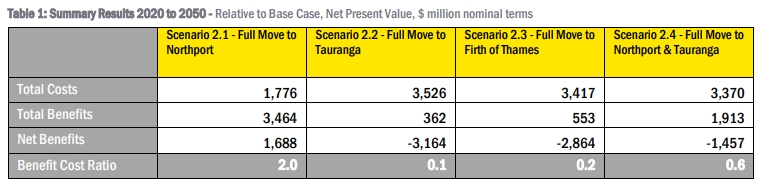
On the same page as that table (69), towards the bottom of the page, it says;
“The Partial Move Scenarios also delivered benefit cost ratios above 1 at 6.8 (Northport) and 4.1 (Tauranga) respectively.”
So those are far better than the full move scenarios, why are they hidden away?…
It’s up to Auckland if it wants to remove its port from the CBD. There’s pros and con’s to it.
But if they go ahead with it: Replacing that port is going to cost an awful lot of money. There’s no existing alternative port in the greater Auckland area to upgrade like Sydney had with Botany when it decided to remove its working port from its CBD.
Some might say that replacing it with an upgraded Marsden point in Whangarei will cost a lot in infrastructure costs. But that would also be the case if the port activity was moved to Tauranga instead. Because the rail link to Whangarei via the Kaimai tunnel is already close to capacity. And that tunnel cost a lot to build single-track.
And has anyone ever thought about building a brand new port out Kauri bay way?
Any option’s going to be expensive.
Maybe this one needs to be put in the more long-term-goal basket?
Personally; if this going to go ahead I think that building Marsden B and upgrading the North Auckland line makes the most sense. Tauranga already has most of the freight from the ever economically-expanding Waikato to worry about without also being burdened with Auckland’s.
Mostly agree with you but one point needs clarification. There is plenty of capacity left in the Kaimai tunnel, the current constraints are due to the number of passing loops between Hamilton and Tauranga, a much easier problem to solve than building a second tunnel.
I guess the problem is relying on a single tunnel for the majority of the countries imports/exports is quite risky. Even a small earthquake could put a tunnel out of use for weeks.
We already rely on that tunnel for a significant proportion of our exports and imports. I can’t see POA moving to Tauranga but whatever scenario is chosen Port of Tauranga will continue to grow and this rail corridor will see greater use in the future.
‘Even a small earthquake could put a tunnel out of use for weeks.’
I’m not sure this statement is correct. Tunnels are often the strongest infrastructure in earthquakes, both the Lyttelton road and rail tunnels were open soon after the 2011 Chch earthquake despite the epicentre being just about under the tunnels.
Slip prone and liquefaction prone infrastructure is what gets really hammered in quakes.
With modern boring machine, another one will surely be made in the future anyway (I see they had fun with one back around 1970 to do a portion of the existing tunnel).
Although I agree that all eggs in one basket’s not a great idea: The NAL has quite a few tunnels along it too.
@ Grant: I’m pretty sure that boring machines 50 years ago weren’t all that different from those used today. There’s very probably heads with more effective rock cutters available now but I don’t think they’d be that much more effective within the Kamai’s rock and that the western end would probably also need to be cut by hand.
Daniel,
Agree as far as unconsolidated colluvial & alluvial sediments plus fault zone at western end. This is area that had the fatal collapse & was subsequently excavated by cut & cover. I imagine any new tunnel would also be cut & cover through this for the same reasons (loose, wet).
The TBM was successful through the ignimbrite formations encountered of the eastern side and bored a little over half the tunnel. They also had good geotech data in advance of tunneling on that side due to to lower height of terrain above tunnel route. No good data for the hard andesite forming most of the western half of the tunnel route: height of the topography above meant no exporatory boreholes with rock type inferred from surface outcrop. What they got right was the hardness, but failed to realise the extent & spacing of the jointing. This what caused most of the problems for the TBM when used on the western heading. Larger blocks (up to ~0.5m) would break off along joints & damage cutters, cutter head, conveyors, etc.
A parallel tunnel would have the advantage of the detailed geology gained from the existing tunnel. Would be interesting to know whether the jointing is something TBM engineers can design around or if it’d be back to drill & blast for the hard lavas in any new tunnel.
Note to all: if anyone is particularly interested I can point you towards some papers on the geology &/or engineering of the Kaimai Tunnel (think they’re paywalled though).
Jezza,
An example of how strong tunnels can be was Tunnel 18 on the Main North Line in the Kaikoura Earthquake, where the Hope Fault ruptured through the tunnel barrel. Major damaged was quite localised to the narrow fault zone (few m). (The offset of the two halves gave a good fault slip vector for that location.)
@GK
I thought the western end was just cut as a cylinder with an increasing radius. How could they “covered” anything? They dug the mountain range away then replaced it?!
@Daniel
I said exactly what I was referring to: “unconsolidated colluvial & alluvial sediments plus fault zone at western end”.
These do not make up most of the mountain range, only a short section at the western end. (As I also said: “hard andesite forming most of the western half of the tunnel route”.) I would expect any parallel tunnel to be cut and covered through this short unstable section for the same reasons that this section was completed by that method in the original tunnel (loose saturated gravel/sand/silt without much height above).
Anyway, a little more on the western heading of the current tunnel:
After collapse in saturated sediments, they then adopted cut & cover until reaching andesitic breccia which was stable enough for the TBM. After ~70m with the TBM they encountered a very hard andesite which is where the problems really began. The rock hardness plus orientation & spacing of the joints (2 sets at ~90°) meant that the cutter/breaker knocked off large blocks rather than breaking the rock down to size suitable for the muck conveyors etc. Lots of damage for little progress (another ~30m). TBM was disassembled & taken to the eastern side where rock was more suitable (ignimbrite/tuff/breccia). Western heading continued with drill & blast.
At the time TBM was ordered they were unproven in very hard rock. Use in the western heading was a trial – the machine was ordered on the basis that it would at least be able to bore half the tunnel from the east. If it worked in the west the whole project would be easier/cheaper/faster. They had 3 months to prove it.
A few papers:
Bennion & Hegan 1977. Kaimai – some tunnelling problems.
Hegan 1978. Engineering geology of the Kaimai Tunnel.
Hegan 2003. Kaimai Tunnel: a Geological Section through an Ancient Volcano.
I’m sure that rail capacity to Tauranga can be increased with passing loops and sections of double track (although much of the line is also on viaducts/bridges which would also be expensive to double-track).
But at some stage even after passing loops, etc.; it will reach a bottleneck where big money will need to be spent anyway. And how much extra traffic would Auckland’s freight generate?
It just seems wiser to me to instead go the whole hog with Marsden point B and keep Tauranga for the Waikato and as a reserve option.
Agree, if it has to be one or other then Marsden makes the most sense.
However, I doubt it will be one or other. Port of Tauranga is already a significant player in Auckland’s cargo and this will likely continue to grow even if Ports of Auckland were moved to Marsden.
Exactly. If Tauranga can compete against a port located in the centre of Auckland then think how well they will do if Auckland loses that advantage. Think I might buy some shares.
The largest constraint at TGA is the TGA yard itself which is nothing more than a large siding with a few roads. So putting longer or more passing lanes on the ecmt may not help much.
TGA yard is constrained in both length and number of trains that can be in the yard at one time. A lot of trains spend quite a bit of time waiting outside TGA yard for the outbound trains to depart before they can get in.
Well we have finally managed to actually get some emotion into Phil Goff….
‘We bloody own the land’ – Goff questions port report
“The threat that they’d pass legislation and nationalise the port and take it away from us, that’s not good enough,” Goff said.
Paywalled at newroom
https://www.newsroom.co.nz/@pro/2019/11/13/908619/we-bloody-own-the-land-goff-questions-port-report
I wonder how much of the land when the port moves will end up I. The hands of Ngati Whatua, you can bet they will want some or most likely all of it.
If you look at the biggest modern cities in the world, they all share a common geographic advantage – deep water port with protection from wind and tide.
Cities are the node of trade, and ocean trade is cheapest and most scalable.
Removing Auckland access to ocean trade may have long term negative economic implication to the distribution, and manufacture supply chain in Auckland.
Ports often create the cities but then get moved out. This is a good read from the ITF, about the effect of the new huge ships, not just on the ports but on the way the cities now need to respond to a port call by a huge ship.
https://www.itf-oecd.org/sites/default/files/docs/container-ship-size-and-port-relocation.pdf
“When large ports are not located in cities, there are usually specific reasons for this. In many cases this is because they are close to natural resources or global shipping routes, or because of a deliberate decision to decongest urban ports… the non-urban gateway ports that were in many cases deliberately created away from large cities in order to decongest the urban ports include Felixstowe (United Kingdom), Laem Chabang (Thailand) and Lianyungang (China)…”
And what is being built on the Thames much closer to London than Felixstowe? You guessed it a brand new larger (when completed) DP World London Gateway container terminal.
What do people think of moving it or partially at least to the Firth of Thames area? It would be quite ideal from a location distance point of view but has a big environmental question hanging over it but then so does Auckland.
Why not somewhere near Kauri bay?
Kawakawa Bay looks better waterwise, and text from the 2016 Port Future Study:
“A port relocation to the Firth of Thames might be
required if more detailed analysis of the Manukau options
demonstrates that it is not feasible, and would reduce any
navigability, safety and shipping issues that might remain
with a feasible West coast option. However, a location at
the Firth of Thames would imply higher costs for land-side
transport infrastructure and freight. The MCA and CBA both
indicate that a Kawakawa Bay location would be preferred
relative to a location nearer to Waimango Point.
Both of the identified Firth of Thames locations would
raise important cultural, social and environmental issues,
described in the Consultant’s report, that would need to be
navigated before an option could be established. Further, the
preferred transport route to the coast would pass through
a rural environment that would be substantially altered by
construction of large scale road and rail link”
Those don’t sound like anything that would prevent this option from being seriously investigated (if it was pushed).
It can’t be anywhere near the bar-tailed godwits. Life is already hard enough for them.
+1
I’m looking at the “biggest most modern cities in the world” that have a waterfront.
New York: Moved most of its port activity to Red Hook in the ’50s.
London: Almost all of its port activity to Tilbury in the ’60s.
Shanghai: Moved most of its port operations to Yangshan Island.
Chicago: Moved all port activities from the CBD during the 1950’s and further developed the ports further south at the Calumet river estuary.
I could continue. The only sizeable/important modern city I can find which still has a large scale port close to its CBD is Amsterdam.
There’s a different between not having a Port in your CBD and not having a Port in the whole region.
Interesting, Amsterdam. Everything is close in Amsterdam due to its density. I quick Google, Wikipedia; and it seems some parts have been revitalised to the west and east of the main central area city area. Looks like nowhere else much to move to perhaps? I note that this is even with the nearby Port of Rotterdam, the largest port in Europe.
This could be the case for Auckland too, revitalise parts of it mainly to the west.
PS: From Rotterdam goods are transported by ship, river barge, train or road. In 2007, the Betuweroute, a new fast freight railway from Rotterdam to Germany, was completed. Delayed by two years, the railway was finished mid-2007, at a cost of 4.7 billion euro, more than twice the original budget of 2.3 billion euro.
Perhaps this is what is really needed from Northland to make it work well then but it would be 170km, we certainly don’t have the density of Europe.
Red Hook is 3km from downtown Manhattan, that’s about as far as Westhaven Marina is from Britomart.
Northport is 115km from downtown Auckland. The equivalent would be New York moving its port to Philadelphia.
The point is that New York city on Manhattan Island does not have any “deep water port with protection from wind and tide”.
Of course the claim that “the biggest modern cities in the world, they all share a common geographic advantage – deep water port with protection from wind and tide” doesn’t stand up to the fact that plenty of “big modern cities” in the world aren’t actually on any coastline. Where’s Beijing’s “deep water port”?
Taijin.
You meant Tianjin?
It’s its own standalone city with a population well over 10 million more than 100 km’s from Beijing (further than Marsden point is from Auckland). It has its own cultural identity and dialect of Mandarin.
Beijing does not have its own “deep water port with protection from wind and tide”.
Neither does Moscow, Dallas/Fort Worth, Johannesburg, Ankara, Mexico City.
So what you are saying is that inland cities don’t have seaports? Profound!
Given that you were trying to argue against it (for whatever reason); I’m not surprised that you find it profound.
So the OP’s claim that:
“If you look at the biggest modern cities in the world, they all share a common geographic advantage – deep water port with protection from wind and tide.”
Has unsurprisingly failed scrutiny. Hasn’t it?
Hamburg, Osaka, Nagoya
Large scale docking activity in Hamburg has since the second world war been moved from the historic docks to new facilities on its fringes such as the Altenwerder and Billbrook.
the London Docklands were next in the CBD, tilbury is just down the river and now there is the larger DW London Gateway Container Terminal under construction.
Amsterdam as a model makes sense – because your politicos are smoking something…
There’s a difference between being taken seriously as an adult and calling yourself “Buttwizard” and posting something that wasn’t even worth mentioning.
Funny, someone else felt the need to make that exact same point about how your examples often involve distances of tens of kms and not hundreds of kms from the region those ports serve. I notice they haven’t received a snippy reply yet or been smugly dismissed.
If it’s all the same, I’ll take the internet tough dude lectures on what is and isn’t acceptable on the interwebs from people who can figure out how a basic in-line reply works.
“internet tough dude”
I expect this level of ironic hypocrisy from any adult man so lacking in self-awareness that they actually call themselves “Buttwizard” (the sort of thing a 12-year-old would call themselves)….
Buttwizard is correct many ports have just moved from central city locations to industrial areas where there’s room for container parks etc. Ports like London have moved down-river closer to the sea to avoid hours of steaming up and down the Thames.
London’s has been moving slowly down river for a while now. Pool of London (just below London Bridge) to the likes of Surrey Docks, Isle of Dogs, Tilbury, & now even further down to the deepwater Gateway …
The vast majority of shipping freight in and out of England’s home counties still comes in and goes out at Tilbury. The Gateway dock has so far been a white elephant (though this could change).
Tilbury’s expansion, containerisation and the increasing size of cargo ships ended the old east end docks 50 years ago and all rather abruptly. Surrey Quays ceased all operations in 1970 and has long since been converted to residential development. The entire Isle of Dogs ceased all operations in 1969 and is now London’s second CBD and only Brexit can stop its continual development.
All of London’s historical old docks are gone; St Katherine’s, Shadwell, Limehouse, East India Dock and the massive Royal Docks (which included the massive King George V dock). And the communities of docker workers & associates who characterised the docks and whose entire lives revolved around the docks are long gone (mostly to Essex) as are the slums they lived in. Nowadays; many cargo ships couldn’t even get past the Queen Elizabeth II bridge nor Thames barrier. Most of the traffic on the Thames into London is smaller passenger craft.
“Buttwizard is correct many ports have just moved from central city locations to industrial areas where there’s room for container parks etc.”
Which ports moved to more industrial areas?
“Ports like London have moved down-river closer to the sea to avoid hours of steaming up and down the Thames.”
Well actually the main reasons London moved its port of Tilbury were:
1) Containerisation. The old Docks with their restricted spaces could not be made to handle the needed craning equipment.
2) The increasing size of freight ships themselves (also tied-in with containerisation), the old London docks were becoming too physically small even in the ’50s. Tilbury was originally the terminal for ocean liners that didn’t want to risk possible grounding further up the Thames. Of course, that was dying by the ’60s.
3) The increasing land value in London.
Shipping traffic along the Thames itself had been in steady decline since the end of the second world war.
Good comment Matt, but the Avodale to Southdown route is not that hard. If you have a look at it closely, you will find that a lot of it was designed to be in a series of cuttings, mostly going under all of the roads it intersects with. Lower down where it comes out near Victoria St and Church St, I suspect that it was to be elevated to cross over Alfred St and the Onehunga Branch before slowly descending to Neilson St and the Southdown yard. Now they may have to consider going over Neilson St too. All of the route is still owned by the NZ Railway Corporation for this purpose, so some businesses may need to be evicted nearer Southdown, but I doubt there will be any private housing that will need to move.
The Avondale southdown line with a direct connection to the eastern line would be great for public transport. It would provide and isthmus circle line from the eastern line, A-S, inner west, and CRL back to the eastern line. Bunching can be prevented by using the WSTFD and western line connections.
A nice metro transfer station at southdown where the isthmus circle crosses the southern line would provide great connections to all parts of Auckland and simplicity of running pattern.
Freight wise too the A -S will be quite important should the northport thing happen.
– running only at night through Auckland is impractical due to loco issues, driver sickness, wagon issues all delaying trains. .
– if it is anything like TGA metroport trains (14 per day 7 north bound 7 south, around 760m long each) then there will be quite a bit that needs to be squeezed through AUCK.
– trains arriving from northport cant drop tonnage in the northeast and then depart back to northport without going through checks, and may require shunting. so a yard in the north east to shunt decent sized trains along with staff will probably be required, … or… the trains will have to get through to wstfd yard for all required checks and shunting before heading back to northport.
Seems odd that the splitting of cargo into different functions has not been discussed here. A container ship will only carry containers – nothing else – and so needs room for stacking, next to a rail line. A car-carrying ship only contains cars, not containers, so arguably can be docked at a completely different port – and to be honest, with more cars likely to be sold South of Auckland rather than North, it makes most sense for all car-carriers to dock and unload at Tauranga, rather than Northport.
But bulk export of produce arguably needs to be in the area closest to where the produce is produced. What are the bulk primary produce exports of Auckland? None?
Meanwhile, Northland exports logs – so they can go through Northport. No need for them to be trucked all through Auckland. Waikato produces milk solids – exported in containers – a different market, different ships, so a different port. So maybe the best, most honest thing for POA, is that it is chopped up into different bite-sized chunks…
Ich liebe Avondale Southdown. And what type of weirdo wouldn’t want to be close to an electric (low noise emission) train line, and the accompanying train stations? Just another example of the civic mistreatment Avondale receives.
In his interview on Q&A, Wayne Brown implies that the move to Northport won’t increase freight costs. But that is misleading. The 2012 UNISA report “How can we meet increasing demand for ports in the Upper North Island” found that there would be an additional $600 odd freight cost per TEU container for shipping between Auckland and Whangarei. I imagine this would lead to some increase in prices.
I tried looking at the second interim report for the current study to see how the economics could stack up given the additional freight costs. Their conclusion that the move makes economic sense appears to depend on getting good sale value for the existing land. I think the report also assumes that relatively more of the freight going through Northport would be transported by rail and so would avoid the cost of freight truck drivers getting delayed on Auckland roads.
But the report doesn’t provide any breakdown of the benefits figures or much explanation so it’s difficult to get a sense if their assumptions on land value, avoided delays and any other benefits were reasonable.
For example, Wayne Brown suggests that the port land is worth $6n, but the second interim report quotes values in the range of just $300m to $1 billion (with projected higher values after they are built on). The text of the report says “These significantly different values indicate the speculative nature of estimating alternative land use values”. It’s not clear what land value they have assumed in concluding the move away from Auckland was justified on economic grounds and whether it may have been inflated.
They also haven’t given a breakdown of their capex estimates so you cannot directly compare what has been assumed for one option with another. With one partial exception: it looks like they believe they need to provide much less new hardstand area at Northport under the move scenario than they would need to provide at Auckland and Tauranga under the base case of keeping the Auckland port in operation. But on the face of it this doesn’t make much sense: under the move scenario you need to make up for the capacity lost at Auckland even before you provide additional capacity to cater for future growth in demand.
The 2012 UNISA report also mentioned that the harbour at Northport could only accommodate a maximum 275m – 300m length vessels to provide sufficient room for turning. This is equivalent to only 4,500 TEU ships according to:
https://www.itf-oecd.org/sites/default/files/docs/container-ship-size-and-port-relocation.pdf
It would be good to know if the turning constraint is real and what implications it has relative to other possible port locations.
Overall, the interim report is rather short on detail and explanation. I hope the final report is clearer.
I had not looked at their report for a couple of weeks and I should rather have said that there is some breakdown of the capex figures, but there is some inconsistency and the breakdown given may not be complete.
For example, they quote two figures for the ‘Full Move to Northport’ option – $6.06 billion and $10.3 billion. They do not explain why the figures are different and only give a breakdown for the $6.06 billion.
They would most likely have to build another 1-2km of wharf, the current wharf is only 560m, the largest container vessels visit NZ today are 350m. I wonder where this wharf could be built, one side has mangrove and a reserve, the other side is the oil terminal.
They would most likely have to build another 1-2km of wharf, the current wharf is only 560m, the largest container vessels visit NZ today are 350m. I wonder where this wharf could be built, one side has mangrove and a reserve, the other side is the oil terminal.
They say they will need about 1.2km of new quay wall at Northport – It’s about the same amount of new wall they say they would need at Auckland and Tauranga under the base case, even though under the base case you would still have all the existing berths at Auckland available. And as I said above they say much less new hardstand would be needed than for the base case. It makes you wonder if they’re sizing and costing Northport for less throughput than they are for Auckland and Tauranga under the base case – which wouldn’t be a fair comparison.
Matt published a picture of the proposed layout in his post above. They’re proposing to develop the northern side.
So if the turning constraint is real, it sounds like they will only be able to fit in smaller ships than those which currently call into Auckland.
The other pachyderm in the room is the capex. $10b may be a fraction of the eventual cost, so cost/benefit ratios which assume the lower figure could be wildly out. There’s no properly estimated costs, QS’ed, engineer-approved, and by all parties (road, rail, ports, TLA’s) so that $10b is likely a PDOOMA.
Reading about the North Port concept…what are your politicians smoking anyway?!
This is easily the most ridiculous spending program I have seen – and I live in Massachusetts.
Distribution centers are best located in such a way to be EQUAL DISTANT to all its markets. Moving north of Auckland is the opposite of distribution Best Practices.
I recommend using the “report” to roll up a big blunt – your going to need one.
People should be following Simon Wilson’s six part look at the future of our waterfront published in the New Zealand Herald. In part two today there is a breakdown of this years freight showing 250,000 cars and 900,000 containers. Lets deal with the containers first. 780,000 contain mostly import goods for Auckland the rest are redistributed via coastal shipping to other NZ ports or the Pacific. So lets say 600,000 of them need to be sent by rail to Auckland the rest either traveling by road or staying in the North. So that breaks down to approx 11,500 per week or 1600 per day. Now a Metro port train from Tauranga is currently 36 wagons or about 60 containers.
So this works out at 27 trains per day. I just don’t know if that’s feasible. The article also states that 300,000 containers are sent from Tauranga which works out at 13 trains per day. There are a lot of these trains but not too sure if there are thirteen. On top of this is 250,000 cars or 700 per day. So if you could get say 8 cars on a purpose built wagon then say 90 wagons so two or three trains. There will need to be a number of very long passing loops to allow for even longer trains. Of course longer trains bring there own set of problems.
Out of interest Royce: I have a note from somewhere regarding ECMT line – from Wikipedia from a March 2018 WRC minutes).
“Kiwi Rail had provided that the current movement on the line equated to 163 train
movements a week. Of that 126 were Monday to Friday and only 36 movements
were between the hours of 8.00am – 5.00pm. There was no projection as to what
that number might increase to with the inland port or how long it may take.
It was provided for members that through the Auckland to Hamilton corridor
project that Council was a part of, the proportion of freight was decreasing in
proportion to the road. The East Coast link through to Tauranga was at 70%
capacity and growing, but that was not the case on all networks.”
There have been some interviews on RNZs Nine to Noon Monday through Wednesday as well. Here is the link to the interview with Wayne Brown:
https://www.rnz.co.nz/national/programmes/ninetonoon/audio/2018724971/decision-looms-on-whether-ports-of-auckland-should-weigh-anchor
In the interview he says that the reason that the Port of Auckland can’t use rail more is because the port is just not set up for rail. But he says Northport will be set up properly, and they will get it all on rail.
Is that realistic that they can load 27 a day, more than one per hour, and unload all the ones coming back in the other direction?
And I’m still not convinced about the value of the land. The container terminal in front of Parnell has height restrictions and won’t be worth the same as land downtown.
So if a container Comes in and is unloaded then reloaded and exported that counts as two containers. Which makes my calculation 27 trains a day seem more possible.
I mean 27 trains a day both ways.
I was assuming the inward and outward movements only get counted as one container, but I don’t know for sure. Each movement might get counted as a separate container.
The metroport trains to and from TGA mostly use 60ft wagons, IM, IC, IBB and IB types. So it depends what you are moving. They can take up to 3 x 20ft containers on each wagon, or a 40ft- 20ft combination. So the 36 wagons could take up to 108 20ft (36 wagons) containers, or 72 containers of a 40ft-20ft combination. It also depends on the weight of each container. They would have to make the NAL up to 2500 tonnes weight restricted to be able to use all the capacity on the wagons.
Don’t know why but I started thinking about a repurposed and expanded Onehunga port instead of shifting Auckland port to Northland again. I have already posted a comment somewhere but I can’t find it that the present Onehunga Wharf could be expanded or probably rebuilt along the line of the current wharf say 1 or 2 kilometres into the harbour and land could be reclaimed to give it working area and limited cargo storage. This would give easy access by road and rail right into South Auckland’s transport, storage and manufacturing areas. A new line to Westfield yard could be built along the harbour edge where the East West link was proposed to go. So no new roads only a short rail connection direct into the heart of the existing transport hub.
So what to do about the Manukau bar. Obviously the existing channel will need to be dredged along its length. So I am thinking if a mole was built on one or both side of the harbour heads would it shift the area of sedimentation (bar) further out into deeper water. Again it would require dredging but maybe the tidal flow would assist to keep it clear. I am thinking about the river ports of Westport and Greymouth. Both have moles on both sides of their entrances and both are situated on the wild west coast and have similar but probably worse exposure to ocean waves and currents than the Manukau. I understand that a flood in the river can clear sediment off the bar. Presumably the ebb would run faster than the flood in the Manukau harbour so maybe it would have a similar effect. Obviously a lot of study would be necessary to ascertain the effects of the moles and dredging on sediment accumulation. But when you consider the alternatives this has a lot going for it especially for transport costs. Anyway what do you think. Just push the subscribe button or give it a thumbs up or down or comment if you can be civil.
Onehunga port is tiny, about 5ha. You’d need a new site to be around 200ha with deep water berths all around. That would be filling in practically everything between Mangere Bridge and Hillsborough.
If you were going to do it on the Manukau Harbour, there are probably less constrained sites with better water conditions on the airport side, probably an artificial island away from existing coastal zones and closer to the river coming out of Papakura for a shipping channell.
That area is still very close to motorways, the main trunk line, etc.
Okay if the wharf is extended 1 kilometre into the harbour and there is 200 metres of reclaimed land along its length then that is 20 ha and not much of an eyesore. It would be enough to handle two or three ships at a time. The port would be so close to existing industry and container stacks meaning logistics would be easier. Rail to Wuri would take about 20 mins. Tauranga and Metroport is not going away and either will Northport. I am thinking more of bulk cargoes and cars which would be more difficult to place on rail although some containers could also be handled.
Well that’s only a fifth the size of the current port, so it wouldn’t be able to do much. I think you’d run into an issue of efficiency. All the cost, the environmental impacts, the dredging of the shipping channel, the reclamation of harbour… to get a facility one fifth the size of the current one. It wouldn’t be worth it, I think it needs to be big and comprehensive to even consider a new port on the Manukau.