Over year to the end of June, the number of boardings on our rail network increased by 5.8% on the year before to a record of 21.4 million.

Every year Auckland Transport kindly provide me with the numbers to break that down by station, including how many people went from every station to every other station.
Before delving into it a few caveats.
- The data is based on completed HOP trips i.e. where both the origin and destination are known. This means trips aren’t included, such as where someone has forgotten to tag off or for special events where travel is included as part of the ticket. This data accounts for about 96% of all rail trips.
- The boarding numbers don’t include transfers i.e. where someone gets off a western line train at Newmarket and transfers to a Southern or Onehunga Line train it’s all considered one journey
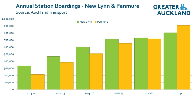
First up, the total number of boardings at stations. The Britomart numbers have been truncated so it’s easier to see the detail of the other stations.

Below are some observations:
- Panmure has seen impressive growth since the upgraded station opened at the beginning of 2014 and this year sees it replace New Lynn as the third busiest station on the network behind Britomart and Newmarket. We also know that a lot of people transfer from buses to trains, more than predicted would, and it helps to show that people will transfer if it’s easy. Once the first stage of Eastern Busway opens, could we eventually see Panmure start to put pressure on Newmarket for second spot? A quick comparison of the recent history of New Lynn and Panmure is below.
- Otahuhu is another poster-child for transferring. Prior to being upgraded only around 100k people used the station, last year there were over 500k boardings. To get that kind of growth through park & ride would have required about 1600 spaces at a cost of $40-100 million – depending on how much of that was in a multi-storey building. It’s going to be fascinating to see what happens to Puhinui once that station upgrade is completed in the next few years.
- In it’s second full year, Parnell has improved and recorded the strongest percentage growth due to the low base it was coming off. That growth makes it now only the 5th least used station.
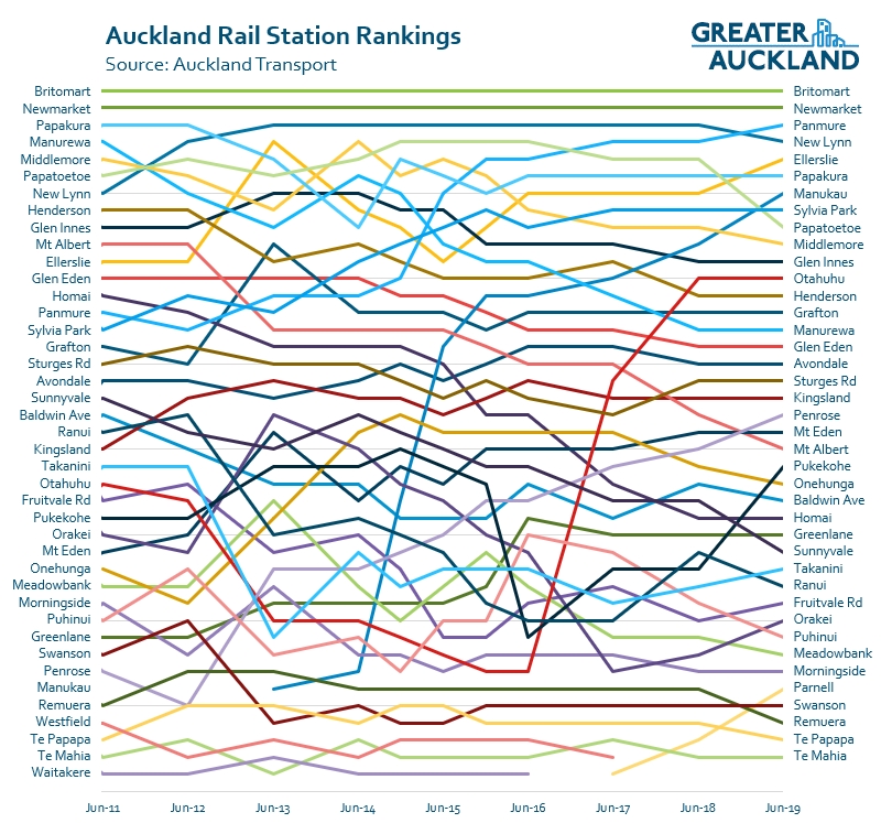
- Te Mahia once again takes the wooden spoon for the least used station. I wonder if the recent upgrade is going to see that number jump in the next few years.
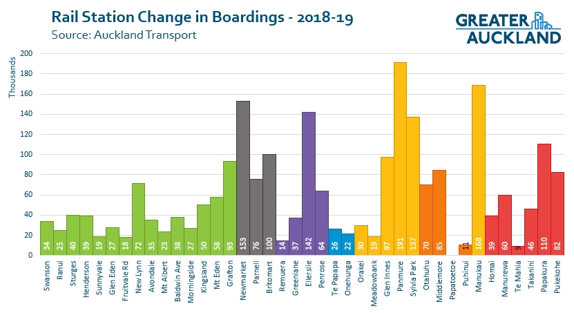
The next graph shows the change in usage by station over the last year. As you can see, there was very strong overall growth at Panmure, Manukau, Newmarket and Ellerslie. The first three are all major interchanges but Ellerlslie is a bit of a surprise. I wonder if this is related to the new bus network as the popular 70 passes by the station so could be picking up some transfers. This time only one station, Papatoetoe, recorded a 6k drop in boardings.
This shows the same thing but as a percentage change. In this case the Parnell result of 82% growth has been truncated
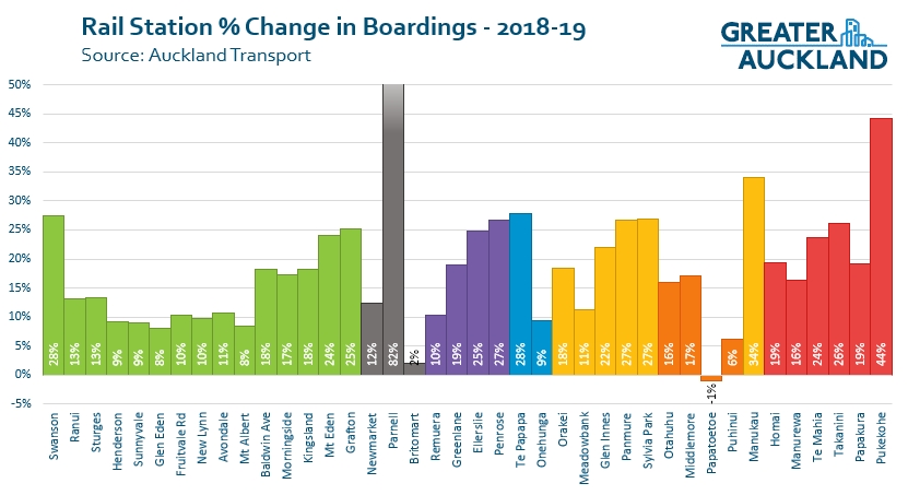
What is most notable about this is that Britomart had the lowest percentage increase of all stations (other than Papatoetoe). This is interesting as it shows the rail network is more and more being used not just for trips to the city but for other journeys too. A few years ago 60% of all trips on the rail network started or ended at Britomart. This year that has fallen to 51%.
Lastly, something we like to call the Rankings Rug – because it resembles a rug with an abstract weave. I’ve ranked each train station over time based on boardings and plotted the results on the graph to see how things have changed. A falling ranking doesn’t mean that boardings have fallen, it usually just means other stations have grown faster and now have more. A few notable changes not already mentioned are:
- Penrose and Pukekohe have both been climbing the ranks fairly consistently over recent years.
- On the other end of the spectrum, Manurewa, My Albert, Onehunga, Sunnyvale have seen their rankings fall as other stations grow faster.
What do you make of the results.
Note: in the past I’ve included busway station in some of the graphs above. AT changed the way they report on busway numbers when they launched the new network and it’s not as directly comparable so I’ve left the results off.

 Processing...
Great analysis! I think GA should sell the rankings rug, well, as a rug. I think it’d look great on our lounge floor.
Quibble: Pukekohe’s growth doesn’t seem very “consistent” to me? Growth fell steeply after electrification (I assume due to the need to connect between diesel shuttles and EMUs at Papakura) and only in last 3-years has relative growth resumed.
You’ve answered your own question I think. Transfer problems. Also new station works then completed, new southern bus network, esp better for Pukekohe, housing growth down there also?
Yes, good point — bus network and station upgrades will have helped. I’m super keen to see electrification proceed — I think it’ll be huge for that area.
P.s. My question was in relation to Matt’s use of the word consistent, rather than the reasons for the apparent inconsistency.
oh yes, I see what you mean.
I would buy that rug! Or a t-shirt
That’s a good idea.
I’d get the t-shirt. (We already have a bunch of rugs.)
Also, worth calling out Manukau as the third-fastest growing station on the network after Pukekohe and closing in on Papakura and Elleserlie.
Be interested to know how the current actuals for Manukau compare to what was modelled in the original business case?
That I would like to know too Stu around Manukau especially post bus station and in preparation for the 38 from 2021
I wonder whether the growth at Manukau is partly due to the Ronwood parking building finally reaching capacity usage?
Could be, but have no idea how full that normally is.
We all know the real reason for Manukau patronage increase is the opening of the Krispy Kreme store near there.
Doesn’t this prove beyond any doubt that linking major centres to rail by rail, rather than the tempting usual cheap and nasty bus option, really works?
Not sure how you derive that from train station data?!?
The Northern Busway carries more people and is growing faster than any of Auckland’s rail lines, for example.
I think what Auckland’s experience “proves” is the merits in developing an integrated network of high-frequency services around a rapid transit spine. Whether the rapid transit function is delivered by busway, light rail, heavy rail, or driverless metro is so-so.
The Northern Busway is not the usual Auckland “cheap and nasty” bus option.
Waspman argues for connecting “major centres” by rail. I suggest the Northern Busway shows connecting such centres by frequent, rapid transit is what matters. And given the context that means BRT for AMETI and Airport to Botany, LRT for Dominion Rd and possibly further afield, and heavy rail for CRL and south to Pukekohe.
Horses for courses of course.
Given its success, I wonder when the Northern Busway will be converted to rail? After all, it was *supposedly* future-proofed for just such a conversion. Or is it going to be another decades-long talkfest?
seems likely Northern Busway will be replaced or supplemented by rail at some point in order to increase platform capacity (both enroute and at city centre terminus).
Papatoetoe has fallen off the trolley
I wonder if it had to do with the northern entrance being sealed off because AT refused to separate the crossing?
I have heard more than a few grumbles that Papatoetoe is no longer accessible as it once was as a result.
For the rest Manukau still surging ahead and I see Papakura is picking up again as well. Wonder if that is all the new developments in the area coming on stream?
I think that is highly likely. The extra walk now for people approaching from the South is exacerbated by the extra dogleg created by the ramp at the southern end. That station has so much potential for improving accessibility.
Maybe it had a large number of fare dodgers who can’t get on there any more due to the gates.
They wouldn’t have been counted in the original numbers either, the drop is the number of fare paying trips being made. The extra walk for people approaching the station from the north is around 250m, it’s reasonably significant.
Not so many Indian students as in the past. Although I am sure that closing the northern entrance hasnt helped. I notice that the car park up by the supermarket next to the relocated old station is acting as an overflow park and ride for the station. Vector was in there repairing the flood lighting this week so I think the council is en ouraging it. It’s not much farther than the official park and ride except there is a set of lights and a pedestrian crossing to negotiate.
Except a P&R wouldn’t change boardings that much, especially one of that size.
Yes Papatoetoe is an interesting one as the airport 380 bus was upgraded to almost frequent in Dec 2017 along with the new Eastern bus network. Perhaps people tried the train, 380 bus transfer more the year before but found it sub-par/inconsistent due to traffic etc & so it’s dropped since?
There had been some bad press about personal safety issues a while back IIRC at this or perhaps it was more Puhinui station that may not have helped.
Anyway, I would agree it probably is mainly the access issue (& the disruption there while working on it).
Actually another thought is perhaps the fancy new Manukau Bus Station has cannibalised some who previously transferred at Papatoetoe.
I know the cycle lanes on station road so no parking there now so 20 cars say 40 boarding per day times 5 times 50 say 10000 per annum. Previously although the cycle lanes were there the weren’t enforced.
Their hard out on the eastern side of Puhinui station scrapping off the beautiful black top soil full of sequestered carbon and carting it away I hope they look after it and find it a good home as managing our soil is about the only thing that will save the planet from a climate catastrophe. Their bringing shingle in its place. On the western side they are cutting the trees down and feeding them through a chipper. I notice there are about 20 cars parked in an informal park and ride there so I suppose they will end up in the council owned car park at St George which I posted about above when Puhinui station is temporarily shut. Maybe they were cars which used to park on station road at Papatoetoe anyway if my figure of 10,000 trips is right at $5 a trip so half a million a year which is a significant amount of revenue even to the anti park and ride purists.
@Zippo could still have a point as some fare dodgers may just not use their valid cards just sometimes when they think they can get away with it. So since the gates they now don’t even use the station.
Re my comment on the 380. can’t be correct Because I checked back on the 2017-18 year and the boardings didn’t increase either.
@ Royce. Don’t think you would get as much as 2X boardings per day on those painted cycle lanes. More like 1 and a bit at most. Perhaps they were used for school drop offs etc somewhat.
I find this decision ridiculous given that Parnell’s been given three gates.
Makes you wonder if geography has something to do with the decision.
(I know, I know… they had just built the ramp at Parnell, but the same logic applies. The difference with Papatoetoe is that they didn’t /need/ to build a ramp. If they were treating the two stations equivalently, Parnell would still not have a ramp at all.)
As a user of the Puke service. It is encouraging to see obvious growth confirmed. Electrification needs to happen ASAP. Any updates on that?
Then take the diesel clangers out West… build up the business case and then electrify there as well…surely!!
agree on electrifying to Pukekohe; not so much relocating the old DMUs on out west. Latter would benefit more from better bus services in the short term and rapid transit on SH16 as soon as it can be delivered.
Any idea on when Puke is happening? Re bus lane and rail. Why not aim for both? Increased resilliance. Also like the data says there is more and more trips being taken and ended along the line rather than britomart. A much higher percentage western busway users would probably be headed to city. Just like NX
Disagree Stu. As you can see from these results people are transferring from bus to train where possible as it is a better user experience. RT to the Northwest isn’t happening anytime soon with all the delays to LRT. With the Northern Line getting upgraded it would make sense to use existing assets until such time as LRT is ACTUALLY built. Buses will be stuck in the same traffic jams as cars.
I agree train is a better user experience, while also disagreeing on NW-RT. Right mode depends on context.
In the case of the NW:
— regardless of what happens with heavy rail, we will need to run buses on SH16 (and develop associated priority and stop infra)
— so options are (1) buses only or (2) buses plus heavy rail; the latter is not a substitute for the former.
And better outcomes for buses can (and likely will) be delivered well in advance of LRT.
So we disagree, nothing new here.
Far better to put the diesel clangers out to pasture or follow their older bros to Mozambique, they are awful. Invest in some new DMU’s , CAF have their Civity which would be ideal and the UK model would easily fit within NZ’s loading gauge.
I was actually thinking new battery EMUs would be the goer for Kumeu, if we were to run services there.
Could be considered after Pukekohe electrification and CRL has been sorted and serviced.
You realise the new EMU’s ain’t battery EMUs now right. They went with standard EMUs, and push the electrification of Pukekohe quicker
Zippo , when KR have finished the upgrade of the NAL from Swanson – Whangarei in the next 12mths AT may be able to use them from then on to Haupi/Kumeu . But 1st thet may have to install a fire suppression system on them to get through the Waitakeri tunnel , but then again they do have an exit through the drivers cab which I don’t think AT realise ?
And Stu AT put the BMU on hold to purchase 15 new EMU’S which the 1st of them arrive before Xmas .
Electrification delivered a doubling in four years (along with fare integration and new bus network) 10-20m. Will the City Rail Link achieve something close to this ~25-50m?
Big ask in raw numbers, so what other moves should be timed to arrive with the huge upgrade in capacity, frequency and access the CRL will bring? There will be the Eastern Busway, Northern Busway extension, A4E, more trains… surely also have North West bus improvements by then too?
But how about a city centre cordon charge, at least, if we can’t switch to full road pricing? Call it an emission free zone…
Yes I’ve been thinking about that too — make the most of a bad situation (Auckland’s motorway noose) by implementing a low, flat fee for people who drive into the city centre. Say $1 each way? Just like a PT fare.
Higher for stinkier vehicles.
$2 for trucks!
No stinky vehicles.
What about Auckland’s C40 commitment to have a carbon free zone – why such a modest fee? And point me to a bus where you can get into the city for $1 each way.
Wouldn’t it make more sense to have a one way fee (less costs to implement) and to pitch it at a level that is dissuasive to want to drive?
I wonder if Britomart’s patronage growth is being constrained by all the construction in the area restricting the walk-up catchment… I guess we’ll find out when the main entrance onto Queen St reopens. This will happen years prior to the rest of CRL opening so should be easy to see the impact of each step.
yes I wondered this too. And maybe more people are disembarking at Newmarket and Grafton to connect with buses to access southern end of city centre?
Mt Eden has become very popular as a train/bus transfer hub amongst university students given the frequencies of the 25 and 27 routes.
excellent point. And Mt Eden shows up as generating decent growth too.
It’s quicker to walk from Parnell to the University than go on to Britomart, hence the sharp upswing in patronage at that station.
To Zippo’s point… there is at least one person I know who’s only been walking from Parnell since they put in the ramp. Now while the ramp has definitely made it faster to get to UoA via Parnell, in my opinion this was the case without the ramp too.* The point I’m making is that it’s not just the station but the addition of the ramp to the station.
It’d be even faster if they did something about the traffic light by the ex-petrol station. Least frequent traffic light ever… easily slow enough to make you miss a train home (although, admittedly, my usage of this route is biased towards low margin for error situations).
* If you factor in the extra time the train takes to get to Britomart and are going to the Business/Arts areas. Probably Engineering and Science if you just cut across Grafton Rd instead of pointlessly walking up to the intersection.
A path/stairway off the Grafton Gully cycleway up to Fisher Price Auditorium would be well-used I’m sure. There’s a desire line there already.
Nicer than walking uphill alongside the traffic and fumes on Alten Rd, and more direct than continuing to Grafton Rd
Yeah, I don’t like the Alten Road route. And it’d be more convenient than navigating one’s way through the Marae.
Yes, getting from and from the south to K Rd I always make a transfer at Newmarket. It’s about a 400m walk from lower Khyber Pass, though – but quicker than staying on the bus to Westfield. Roll on the CRL!
I also wonder if more gating stations and new transport officers has caused fare evasion to drop and also increase registered trips out side of the city center.
I do still notice a few people clearly riding the train for free, but it does seem a lot less noticeable than few years ago
Papatoetoe has been gated and has seen a drop in patronage, so I’m not sure that is the reason.
My guess is that people who used to ride for free are probably not riding anymore rather than paying for their trip.
Free riders wouldn’t have been counted anyway!
Why wouldn’t they have been counted? Unless AT made some sort of adjustment to the count based on the estimated level of fare evasion.
The counts are based on hop card trips with a valid tag on and tag off. If you’re not tagging on and off you’re not counted, ergo fare evaders aren’t counted.
@NickR One interesting thing from the latest AT Board report was the introduction of paper tickets that can be scanned through ticket gates and posts so next year we’ll have not just HOP card data but paper ticket data too so pretty much all pax except for special event users will be covered.
good point. I suspect the revenue protection measures (gating stations, on-board checks etc) AT has put in place over the last few years will have boosted patronage and revenue. Both of which are positive!
Note also that children travelling free on weekends with HOP is likely to reduce fare evasion (and increase recorded patronage) even further.
And as patronage grows, the business case for gating more stations likely increases, as higher passenger volumes (and higher fare evasion) increases the revenue. On that point: Has AT published any plans for gating more stations post-CRL? I’m thinking some on the western line might tick over into the “worth doing” category.
but Ellerlslie is a bit of a surprise. I wonder if this is related to the new bus network as the popular 70 passes by the station so could be picking up some transfers.
And it now has feeder buses from One Tree Hill, rather than the old bus route that kept 700-1,000m from Greenlane/Ellerslie.
Second that. I see people get off that bus and take the 06:25 (Onehunga) train at Ellerslie most mornings.
Ellerslie is very accessible from local schools, residential and commercial areas (commercial and schools along Great South Road).
Also as you say a very popular multi-modal option to jump off the 70 Bus and grab the train, especially during peak traffic times. I wonder if the Panmure upgrade actually contributed to the dip in Ellerslie ridership 2013-2016 because of this type of journey reduced when the interchange came on in 2014. It’s back up again now.
Yes the 295, 298 & highly frequent 70 bus all would of contributed.
The number & popularity of the 70 double decker buses perhaps, perhaps some encouragement to use PT with the start of the AMETI road works contributed a bit too.
Transfers bus/rail would be even better if the off-peak rail frequency was better than every 20 minutes.
yes, few things screw-up wait-times more than running your bus and train network at 15 and 20-minute frequencies, respectively!
Off-peak train frequencies (especially midday) in Auckland are painful.
Midday, and still weekends. They should at least be targeting 15min frequencies off peak in the short-term and going to 10min long-term (What is the off-peak frequency post CRL opening? 10mins?)
Matt you say they can’t work out the transfers , there must be a way as all Hop show the start and end of each trip i.e you get on at Swanson then get off at Onehunga so when you check out your trip online the following day it shows your trip and cost , so why can’t AT then use those figures . As there is no service that goes there direct and it must be in the system there somewhere ?
And the other bus is the 321 that stops outside Ellerlise was not mentioned as I have done it a number of times , and I have found the way they designed the crossing and station have a cosy feeling compare to some others on the network .
It is true that HOP records start and end of trip.
The challenge is that there are usually multiple possible paths between where journeys start and end, e.g. people can change at more than one station to (in some cases) more than one line.
So you need an “assignment algorithm” that takes raw HOP data and assigns passengers to potential paths. As not all people will use the same path (due to idiosyncratic preferences), these algorithms typically predict a probability distribution across potential paths.
Now, all this is actually rather straightforward and readily / regularly done. The firm I work for has just completed precisely this exercise for a major rail operator in Australia, for example. AFC’s modellers will also likely already use such algorithms in their strategic transport models.
Problem is that such tools aren’t so widely deployed in the ticketing world. Personally I would suggest coding a simple PT assignment algorithms directly into the HOP ticketing database, but hey I’m just a punk so what do I know?!?
They can work out transfers. What I mean by that disclaimer in the post is a trip from Swanson to Ellerslie counts as one trip, so isn’t listed as alighting at Newmarket and boarding again at Newmarket thereby inflating the numbers
sorry Matt still confused. Do you mean *deflating* the numbers?
It would inflate individual stations like Newmarket in the example above I guess is what’s meant.
If you counted each vehicle used (one from Swanson to Newmarket and another one from Newmarket to Ellerslie) it would inflate the number of trips reported. It also makes it harder to see how people are actually traveling
As Stu’d pointed out there is a multiple trips option.
For example, on those rare days where I’ve bothered going via Orakei (for the view!) to uni, I’ve got off at Puhinui most of the time but I’ve also waited and used Papatoetoe. And if I’m using the Eastern line going south usually I’ll wait at Britomart (to catch the view) but I’ve also just gone to Otahuhu and waited there (and on a whim I once decided to transfer at Middlemore). So you might call me a “first possible station” transferrer (most of the time). But there’s this dude I used to see who would always get on at Puhinui who would therefore be a “last possible station” transferer (we have a mutual acquaintance who told me he works in Panmure or something).
You’d have to do some kind of survey to figure out the distribution of transfer behaviours among the transfer population. I would hope Stu’s firm did something like this in the example he mentioned.
CCTV analytics could be used to gather data on which stations are being used for transfers. (Person X alighted Train A, stayed on platform, boarded Train B).
Surveys would be valuable to get the whole-trip story, and fill in the whys that you’ve gone into in your post
If they went all-in and joined facial recognition and HOP cards you could get incredible data, but I think that would be unpopular, to say the least!
Why such a fall at Mt Albert? It’s had a new entrance added directly to New North Rd and is more accessible than before but it continues to fall in the rankings.
Mt Albert’s a station that’s a bit disconnected from the bus network via car-favourable traffic lights. As well, the nearest Outer Link stops are 2-300 metres from the station. It may also have suffered from declining enrolments at Unitec.
Yes, the bus-train connection needs attention and will require prioritising PT and walking over general traffic amenity.
Mt Albert usage grew 8%, it didn’t fall.
If it’s lower in the rankings that only means that there are other stations that are growing even faster.
Yes, also stew upgrade was on progress over this time IIRC.
Also noted that although it has the lowest patronage on the network, Te Mahia has shown good growth since the station was upgraded earlier this year. Also Takanini for the same reason. This does illustrate the importance of providing decent facilities to attract patronage.
Other good growth recorded at Swanson (bus connections from Waitakere must surely only be a small part of this) and Te Papapa (why?)
wasn’t there a park and ride expansion at Swanson?
I wouldn’t class the growth at Te Mahia ‘good’. It’s had some growth but if yet to show it justifies it’s existence. It should have been shut.
As for Swanson and Takanini, they’re low but still considerably larger than Te Mahia and the growth is nothing to shout about. Both have had P&R built/extended (Swanson a few years so, Takanini this year). Swanson growth is probably related to the housing going in next to the station
That’s a pretty hard line attitude for a station that had 25% growth or thereabouts in the period after serious improvement, Matt! Yes I know that there were plans for relocating stations in the area and I suspect that AT got sick and tired of all the local politics that resulted (including pressure from developers that might have left AT open to accusations of being in their pockets). I think it was easier to bite the bullet and maintain the status quo location – in the meantime at least.
What we forget, though, is that Te Mahia is the local station for the very inaccessible and extremely deprived Randwick Park suburb. To move the station from there would have been a slap in the face to a community that is already transport- deprived. I’m quite cool with the upgrade and continuing to serve that suburb.
For a period, I used Te Mahia on a daily basis, commuting TO the area. I couldn’t have realistically taken the job without the rail option. So I do have a bias in its favour on a personal level as well!
And re Te Mahia, let’s not forget the massive Manukau Golf Course subdivision currently being undertaken by Fletchers. Te Mahia will be their local station as well.
Just a quick back-of-envelope calculation: If Te Mahia managed 25% growth in the year, let’s assume all that growth occurred AFTER the upgrade. Can’t recall exactly when the upgrade was finished, but assuming 6 months without upgrade and six months with upgrade., that represents 50% growth after the upgrade. Obviously not scientific but you get the picture: even though off a low base, Te Mahia is showing some serious potential, and the Fletchers development is only going to improve that further.
That makes sense. Just looking at Google – https://www.google.com/maps/place/Te+Mahia/@-37.0396102,174.9017276,1076m/data=!3m1!1e3!4m5!3m4!1s0x0:0x4297305eae6688dc!8m2!3d-37.03118!4d174.9061
Please tell me it wasn’t all 1 and 2 storey development based around the car. They had a whole golf course to play with …
One of the reasons they left Te Mahia and didn’t move the others IIRC is that development was coming & they were going to wait and see the impact on use. Before the upgrade I have children’s friends that would use Manurewa instead so, in their words, “they wouldn’t get murdered”. It is pretty hidden away and I guess had a real gritty unsafe vibe. Shows you the importance of visibility & “vibe” for encouraging safety in urban planning.
Indeed – Te Mahia was seriously grungy. It’s like a real station now.
Here’s the document I remember reading (Probably was linked to in this blog near that time.), quite interesting read actually:
“AT SOUTHERN STATIONS REVIEW – December 2014”
https://at.govt.nz/media/990442/Southern-Rail-Stations-Information-for-release-18-February-2015.pdf
“Board Resolutions
The Board:
Endorses retention of Takanini station
Approves improvements to Takanini station including park and ride, subject to the availability of funding.
Confirms that AT does not support a station at Glenora.
Approves further investigation of a potential station site at Tironui.”
Grant the thing I have noticed when going around the network is the the type of shelters at different stations it seem the poorer the area the less they get , i.e richer suburbs seem to get enclosed shelters and the poorer ares seem to just have a surplus bus shelter . The worst was westfield before it closed had nothing no wonder the numbers there were so low unless on a rainy day you had an umbrella you got drenched .
I suspect better shelters are more to do with a stations patronage, how recent it was upgraded, cost factors & extra local funding may supplement or be paying for it.
Think of Orakei or Meadowbank in terms of the walking ramps etc quality.
Pretty sure Westfield fate was decided but they kept it running until a new timetable, new southern network & new Otahuhu station were opened. Why bother upgrading it if it was to be closed soon?
Intensification around New Lynn has stalled.
Some of the proposed residential development are put on hold.
The vision for intensified TOD suburb are handicap by western line due to long journey time and poor off peak frequency.
I suspect that’ll all change post-CRL …
New Lynn redevelopment stalled because after amalgamation Auckland Council ignored it and it has been left off all the plans.
West Edge development in New Lynn http://www.westedge.co.nz/
Whether it will meet the required per-sale level to allow the development to go ahead remain to be seen.
In contrast, the Glen Eden apartments is making some good progress.
Yes will be interesting they are talking a good game, even proposing to offer a free e bike/ bike with each unit.
Yes Penrose has done pretty well as I have been anecdotally observing at various days of the week at different times of the day. As industrial & sub-par as it is, it also provides good transfer to and from the frequent 66 route which started last July.
Yes, the 66 and then the train is generally the best way to get to the south from Pt Chev. I notice the patronage on the 66 seems to be really good now people know it’s there, even at 6:30 in the morning, with a few people transferring.
That’s good. I remember when the New Network started and most of the 66s appeared to be near-empty – if not completely empty. Good to see people starting to adapt to the new Route 20 as well – that was a depressing ride when it first opened.
21 Million boardings sounds quite a lot until you compare it to London tube lines. The Northern, Central and Jubilee Lines EACH have boardings approaching 300 million.
Also interesting to see Britomart continuing with very low new demand. This is consistent with the increase in inner city residents well ahead of the increase in jobs. Apart from Commercial Bay there is also very few new office buildings being built or planned. It would seem there will be very little demand for the CRL should it get completed – except perhaps going out of town!
What about all the development around Wynyaed quarter that is an easy regular bus trip via Britomart?
And the convention centre and buildings around it?
Yeah I live and work in that area and there’s heaps happening (Manson building a new office block right next to my own apartment on Fanshawe) …and at the end of the day, heaps of people taking the city link bus and getting off at the first stop on Queen Street. There’s also building going on in Albert St with the new Holiday Inn, and around the corner on Victoria with the Ramada. And also some big apartment buildings on or near Custom st West.
Anyway, as has been said a million on times on this blog, the CRL is nowhere near being just about the central city, as it is being about the whole network. Maybe the gentleman would like to go to the CRL website and familiarise himself with the project a little more.
Also as other posters have mentioned, having a construction site around the station and in multiple places nearby, isn’t normally particularly inducive to attracting people to use it.
That made me think a small factor maybe the new network 20 & 75 bus taking people directly to Wynyard cannibalising train journeys to Britomart & a walk or bus transfer.
In the past few months the 20 at peak has been near or at standing room between Kingsland and Wynyard, whereas for a while after launch it was nearly empty.
Does this perhaps reflect pax transferring from the Western Line, at least in part? Are there users also from Auckland Girls’ Grammar and St Mary’s College?
Do the “boardings” include exits and entries from the system or just entries? E.g., Parnell has 168k boardings, does that mean 168k people got on and off in Parnell or just got off there?
Boardings are just entries, people getting on board.
If Parnell has 168k boardings it will also have 168k alightings, give or take a few hundred.
Would be interesting to see how the numbers compare today.