Greetings again from Greater Tauranga. This is our second post. You can read our first post here which gives an overview of the complex transport system in our region.
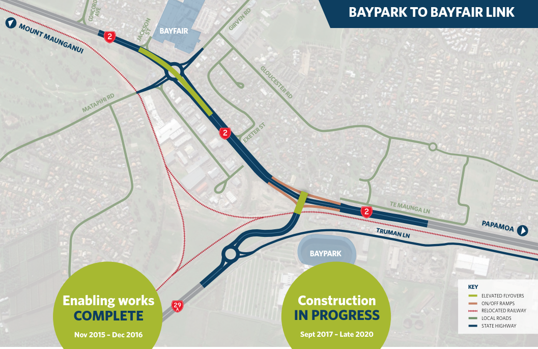
This post is about the Bayfair to Baypark (B2B) project, the story of what happens when a road of national significance (RoNS) meets the edge of a growing city.
While local National party members are attempting a last ditch effort to keep the road building dream alive, we are witnessing the effects of one of their flagship projects.
The Tauranga Eastern link (TEL), poster child for the RoNS, sails toward our city in a blaze of lights, smooth tarmac and state of the art safety features. The road stretches from Paengaroa to Papamoa and is a ‘dream to drive’.
The road has encouraged commuting and urban sprawl along this corridor at such a rapid rate that traffic on Maunganui and Hewletts Rd has increased markedly in the last two years. To a point where now it all screeches to a halt where the TEL ends at Baypark Stadium and the daily crawl begins.
NZTA is now focussed on completing the motorway’s free-wheeling romp towards the city and port, with $120 million being poured into the next 2km of road.
In essence, the B2B project involves extending the TEL further towards the Mount, and removing two ‘constriction’ points (roundabouts) and replacing them with flyovers. One is at Baypark Stadium (Te Maunga), the other is at Bayfair roundabout. The project then merges back into SH2 just prior to the Hewletts Rd flyover. More information here.
The big elephant in the room, however, is that it all ends on Hewletts Road, already stretched beyond capacity, that would need a flyover of Tokyo proportions to allow freeflow traffic, given our current rate of car dependency. A recent article stated that:
“Predictions made in 2006 that Hewletts Rd would be congested within 15 to 20 years of the completion of the $225 million Harbour Link project have come true almost twice as fast as expected”.
Refer full article here.
Ironically (although I’m sure most of you are over road-inspired irony) the business case for the B2B does not include what happens outside the boundary of the project. And so, the B2B was justified on a three minute travel saving time on the new stretch of road only, which stacked up tidily at a cost benefit ratio of 2.8 and justified the project.
It has, however, been stressed by NZTA that one of the main objectives for the project is to get trucks to Port of Tauranga efficiently, although this argument was actually disputed by NZTA’s own peer review (Appendix to the Business Case document) and no freight benefits have been allowed for in the benefit assessment.
Trucks will inevitably end up jammed on Hewletts Road along with everyone else.
Here they will belch diesel for the foreseeable future, ensuring our continued skyhigh carbon emissions, while we take bets on what will come first: A rethink of our national port strategy? electrification of our fleet? Or god forbid the Government capitulates to the National Party petition and sets aside a billion dollars to box on with an overpass down Hewletts Road… then of course we’ll need to somehow connect to the four lane Road of National Significance coming in from Katikati in the other direction.
A legacy project.
All agree that it is necessary to do something to relieve the congestion in this stretch of road, but off the record, NZTA admits that if the project was designed today it would look a lot different. It is what they call a “legacy project” (polite terminology for an outdated idea that we unfortunately committed to in the past, and are now stuck with).
In our view this project lacks vision and a commitment to multi modal solutions for transport. Below we have summarised what we believe to be the major problems in the design:
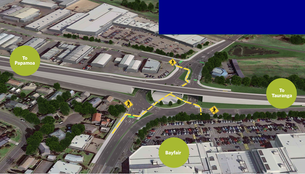
- The walking and cycling design for B2B has improved as a result of cycle advocacy group opposition in 2016. However, the busy existing ped/cycle underpass at Bayfair is being removed, and there is no commitment to construct a safe overpass or replace the underpass linking Bayfair to Owens Place. Instead, pedestrians and cyclists will need to cross nine lanes on foot through multiple sets of lights – almost all of the services for the Baypark/Matapihi communities are across this motorway, including local schools, medical services and supermarkets.
This next image is of proposed intersection layout, showing the pedestrian/cycle pathways from Bayfair and Girven Rd across to Owens Place. If you were wanting to cross from the left hand bottom of the intersection you would need to stop at 4 sets of cross signals/lights.
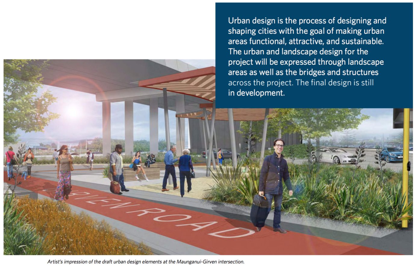
This last image shows an impression of what NZTA would like to have us think the crossing may look like. Yes folks, what you see here is people enjoying the serenity in the middle of the roundabout, and under the motorway! And don’t you love the irony of the urban design text!
- There is no bus lane proposed as part of the B2B project – so there will be no way for rapid public transport to access the existing bus lanes on Hewletts Rd. NZTA is apparently considering a separate project to add bus lanes in the future, rather than building them at the same time. Given there are 15,000 new homes planned at Te Tumu, we think this is a major oversight (reminiscent of SH16 in Auckland).
- The “Western BOP Public Transport Blueprint” proposes express buses to Bayfair from both Papamoa and Te Puke. This would be an ideal time to create a future-proofed interchange alongside the B2B at Bayfair, so the express buses can easily stop at Bayfair / Owens Place and then continue along a bus lane to Hewletts Rd and into Tauranga CBD.
- Instead of this, Tauranga City Council is proposing a new Bus Interchange behind Bayfair on Farm St. This interchange will need to manage approx. 20 local buses per hour plus regional and intercity buses. Farm St is a narrow residential street, designated a ‘local road’ under Tauranga City Council hierarchy and therefore not suitable for location of a bus interchange. This location does not lend itself to quick and efficient bus movements to enable reliable services.
- BOPRC is currently in agreement with the Farm St location for the bus interchange and is proposing the main bus route north along Farm St and Links Ave. These are residential streets that are completely gridlocked during peak times because of school and commuter traffic. We understand that the reason BOPRC does not favour an interchange beside the B2B is because it will be too difficult to access following construction of the B2B (across the highway – because NZTA is removing the pedestrian underpass). You can begin to see the ludicrous picture emerging!
In summary, we think there needs to be an urgent review of B2B by the government, in conjunction with the local projects – as they can only operate effectively if they are considered TOGETHER. These projects will shape our community for years to come – and we need to get them right. We need a solution that meets the future needs of Tauranga, provides for non-car based modes, and does not worsen the existing situation either in terms of congestion or safety of pedestrians, cyclists and motorists.
We point out that the project itself has not begun its construction, although enabling works have begun. We understand there are design issues which are still being worked through. So there is still time to fix things!
What do you think? What should we be getting for our $120M?

 Processing...
Thank goodness the National party aren’t in power, otherwise this monstrosity would most certainly end up going ahead. I fail to see how it could ever have a BCR 2.8 when all it is doing it moving the snarl ups closer to the Port of Tauranga.
I can’t see how removing the existing ped/cycle underpass at Bayfair can be justified. Compare the Te Atatu underpass with the crossings at Lincoln Rd. Hardly encouraging.
Overpasses are often circuitous and have poor grades for cycling, which I suspect would be the case here.
Thanks Greater Tauranga. What would you say is the reason for all this craziness?
A) Idiots
B) Vested interests
C) Silos
D) Other (please specify)
Hi. Most NZTA and local council staff agree it is a dumb project that will probably do more harm than good in its current state. The problem is silos, no flexibility in planning processes, and ultimately a lack of leadership. Pretty sad really.
D) Sprawl dwellers and petrol addicts vote for us.
Denser shared environments foster empathy for others and tolerance of diversity and we bloody need to nip that in the bud.
“Denser shared environments foster empathy for others and tolerance of diversity ” – not inevitably. Certainly where my sister lived in Huddersfield the population was dense and diverse but tolerance was variable. Now she has retired to a less dense suburb in York and things seem more tolerant. Same applies to her daughter who lived in a friendly low density fringe suburb of Oldham unlike most of a town otherwise not famous for tolerant diversity. There may be other factors such as class and wealth.
Most developing cities have new apartments built in the centre and close to transport hubs – this is your denser shared environment – and of course only middle class families and single students can afford to live in them. Money and property ownership makes people tolerant and of course you may see it as successful ethnic diversity but ignore the absence of class or age diversity.
We have a similar problem in Christchurch. Two motorway projects directed at inner city Christchurch from the north and south west, which will dump thousands of extra cars onto an already congested manly single laned local road network in St Albans and Sydenham etc. The volume of car traffic scares cyclists off the road -which then adds to more cars. Buses are stuck in traffic -cannot pull out of stops -so are a slow and unattractive option.
What was needed was to have built the motorway with BRT in mind. So if through the central congested areas there was an alternative uncongested high speed bus route connecting to the motorway then the new motorways could have served both cars and buses -which would limit the car induced congestion and urban sprawl…..
Investing in commuter rail before the motorways would have helped too…..
+1, I thoroughly agree with all three of the routes currently being built, but motorways really aren’t needed. A single lane Dutch style ring road would probably do the job.
Bill English’s comments this afternoon that the Government is hanging on to an outdated idea of trees, trains and trade unions shows that he, like his party, is a dinosaur. I was walking around the city today around Fanshawe Street and it struck me how horrible the car-centric cities of the 60’s and 70’s were. We are slowly changing it here, I hope Tauranga can do the same.
The current Cost Benefit analysis processes are clearly entirely corrupted from any reasonable relationship to reality.
And seriously if most agree this is poorly designed can it not be reviewed?
Reputational risk to NZTA looks very high here…
There are so few cars (3) shown in that artists’ conceptualisation of the roundabout it is a wonder they had to design it with two lanes? And there are 11 pedestrians in the same picture. Wow! That gives an active transport mode share of 78% in Tauranga. No need for motorways at all. Just build bikeways.
Too bad there are no “truth in advertising” laws that apply to roading projects.
It’s pretty much the same image of idyllic Parisian meanderings under the flyover that was used for the Basin Reserve. The advertising standards people should look into these false claims. Maybe we should just insist that no artists impressions are used but instead just take some pictures of the environments under existing flyovers in other places to give people an impression of how this will look.
https://goo.gl/maps/xjJ4NjnnULC2
‘but the public would never accept that as an aspiration’
Exactly. Great local example. You know if what’s proposed is built it will look precisely like that in years to come.
When they first started to explore how the Murapara forest was to be exploited they looked at building the pulp and paper mill at Murapara they then decided to build it at Kawerau. The rail line to Murapara had already being started so that’s how the log trains of today got started with logs travelling to Kawerau to be pulped and to the Mount for export. At the same time a new port at Whakatane was an option but they decided to go for the Mount. probably because they wanted the trade from the Kinlieth mill which had to travel via the old rail line through the Karangahape gorge. You know there is actually not all that much land left at Mount Maunganui.or Sulphur Point for that matter. A lot of land is taken up with log and container storage and the rest is industrial, commercial and housing.. Log and container land could be utilised for commercial activity and perhaps housing if rail served sites were developed at places like Paengaroa or Taneatua for logs and Waharoa, Awakeri and maybe Apata for Containers.For many years there was talk of extending the Murapara line to Taupo. So we could have inland ports and rail shuttles if we could get things together and not let the trucking companies rule our country.
Passenger trains between Katikati and Paengaroa could reduce some of the traffic.
Sorry I meant Apata and Paengaroa although It would be possible to rebuild to Katikati I suppose..
I live amongst this nightmare reading. What should and did take 5 minutes to work is now ridiculous. They have started changing the roads which in turn snarls the traffic even more. And the bulk traffic condensing into Hewletts Road is ridiculous and dangerous. Every day I see near miss accidents and plenty of toad rage. I’ve lived here for near on 20 years. Who would of thought it would come to this in our sleepy little seaside town. So many locals ( us folk being here for some town not new arrivals trying to be locals) are leaving in droves. Needs to be sorted.
An angry amphibian would certainly out a damper on my commute.
“Increasing Highway Capacity (is) Unlikely to Relieve Traffic Congestion” according to a paper referenced by California’s Department of Transportation
http://www.dot.ca.gov/research/researchreports/reports/2015/10-12-2015-NCST_Brief_InducedTravel_CS6_v3.pdf
“You can’t build your way out of congestion” said the head of planning, Connecticut DOT, so why are we still suggesting increasing road capacity in response to road congestion?
This is of course (as the above article suggests) something of an existential crisis for traffic engineers who have spent their lives planning new roads.
Interestingly, from my reading, it seems that anything that takes cars off the road, such as public transport or cycle commuting, leads to more roadspace which is taken up again by induced traffic.
In light of this a “congestion free network” only exists for the non-road network users; people using buses on bus lanes, people lucky enough to have a rail network, people using a cycle network such as might exist.
This is fine for those who can access these alternative transport networks, but what about trade vehicles travelling at peak times? In Nelson we have proposed a clearway lane for buses and trade vehicles, leaving just car commuters exposed to congestion.
It seems to me that the only real solution for road congestion is by congestion charging that varies by time of day. Everyone should see the superb TED talk about how effective a small congestion charge was in Stockholm here:
https://www.youtube.com/watch?v=CX_Krxq5eUI&t=4s
And here is a study on induced traffic, including induced traffic from public transport:
American Economic Review 101 (October 2011): 2616–2652 http://www.aeaweb.org/articles.php?doi= 10.1257/aer.101.6.2616
The Fundamental Law of Road Congestion: Evidence from US Cities†
By Gilles Duranton and Matthew A. Turner*
We investigate the effect of lane kilometers of roads on vehicle-kilometers traveled (VKT) in US cities. VKT increases proportionately to roadway lane kilometers for interstate highways and probably slightly less rapidly for other types of roads. The sources for this extra VKT are increases in driving by current residents, increases in commercial traffic, and migration. Increasing lane kilometers for one type of road diverts little traffic from other types of road. We find no evidence that the provision of public transportation affects VKT. We conclude that increased provision of roads or public transit is unlikely to relieve congestion. (JEL R41, R48)
“http://pubs.aeaweb.org/doi/pdfplus/10.1257/aer.101.6.2616”
Yes agree. It seems clear now that the only way to “solve” congestion is to price the roads.
It is disingenuous to say that cycling or public transport can reduce congestion. I am a huge supporter of improving both because they give alternatives to sitting in congestion – but they will never actually reduce it. Even cities with great cycling and PT have congestion.
Yes but high quality alternatives can render traffic congestion more or less irrelevant, or optional. Opt-in. Currently for too many Aucklanders there is no choice but to suffer it. Expanding the reach of the Rapid Transit Network is urgent.
The congestion issue then becomes its effect on freight and deliveries. But these are fixable with lane and curb side priority.
The pedestrian/cycle access in the picture looks horrific…unsafe and accidents waiting to happen. Hello bus lanes, hello public transport, hello tolls to pay for it and reduce demand. Sounds like NZTA needs to take a look in the mirror, and make some PT oriented changes.
Perhaps they could spend the money fixing up SH2 west of Tauranga! It’s a nightmare to drive on and dangerous.
Thanks for post. Every new project certainly needs to think of a multimodal design these days.
Tauranga needs a suburban rail service to provide the city with a decent public transport system which is not road based and is not going to be affected by road congestion like buses. The city is well suited for a suburban rail operation with having rail lines running through the urban area between Apata and Te Puke and runs right into the CBD in Tauranga, Mt Maunganui and Te Puke. With new suburban stations, much of urban Tauranga would be within walking distance of a train service.
The new Government should look to immediately purchase the ADL DMUs from Auckland Transport for KiwiRail to fully refurbish with the intention of eventually using to start a new suburban rail service in Tauranga, for which the ADL DMUs would be ideal for, but initially leasing them back to Auckland Transport to continue running the Papakura-Pukekohe rail shuttle service with until electrification is completed to Pukekohe. In the mean time work could be carried out in Tauranga building the necessary stations, platforms and park and rides across Tauranga, including a new platform in Tauranga CBD on Dive Crescent near The Strand on Tauranga’s waterfront:
https://goo.gl/maps/RhHDGXicjvF2
A platform could be built on the siding in this area and this would keep the main line free for freight trains to pass while passenger trains are stopped at the platform.
Another platform could be built right in the heart of downtown Mount Maunganui on the corner of Totara Street and Rata Street where the old fire station is located on the corner:
https://goo.gl/maps/HQ2KYCMqcUs
Both these stations could also be used by a new inter-regional passenger rail service to Hamilton and Auckland.
A large park and ride could be established at Apata station where commuters coming in on State Highway 2 from Katikati and beyond could park and catch trains into the city from.
What running pattern do you propose given that the Mt Maunganui Station would be a dead end? I can’t see suburban rail working in Tauranga while there is such a circuitous route between Tauranga and Mt Maunganui.