Yesterday the Council’s Planning Committee approved a draft version of the Auckland Plan. This will be consulted on next year – at the same time as the Long Term Plan, the Council’s 10 year budget. A little press release after the meeting confirmed the important step:
Councillor Chris Darby, Planning Committee chair, says the Auckland Plan is an enormous task that sets out a grand vision for the next 30 years that is dynamic, exciting and almost changing by the day.
“The Plan is the way we share with Aucklanders how the council will address all the big issues facing our region. It provides certainty to Aucklanders, Mana whenua, government and the private sector about where and how we will grow over 30 years further reinforced by our other strategy and delivery plans.
“Further work and public consultation in the new year will help to shape the Plan to further reflect the views of our communities.
“We also expect to see some significant contributions from the government in the new year as it develops its government policy statements on the big issues like transport, housing and urban regeneration which are all components within our Auckland Plan”, says Councillor Darby.
Given how much of a big deal the first Auckland Plan was, this “refresh” seems to have generally passed under the radar. We briefly discussed the transport section a few weeks back, highlighting a concern that it was a bit bland. It seems that some minor subsequent changes have occurred, but overall the “Transport and Access” remains a bit bland. Hopefully through the public consultation process and with a government now interested in a bold vision for transport, that might change in the coming months.
Alongside the transport section, the other part of the Plan which is of most interest is the Development Strategy. It runs from pages 222-279 of the Planning Committee’s agenda and is perhaps the most important part of the Plan, outlining the key strategy for how Auckland should grow over the next 30 years. Quite a lot of the Development Strategy is carried over from past plans, either the old Auckland Plan or the Unitary Plan. But it seems that a few key changes have been made, and not all of them make sense. Let’s run through two key issues:
- The new “nodes” of Manukau, Westgate and Albany.
- The strange and inconsistent approach to “Development Areas”
Nodes
It seems that a key initiative of the new plan is to “raise up” Manukau, Albany and Westgate from being three of ten Metropolitan centres in the old Auckland Plan (and the Unitary Plan) into being “nodes”. The plan describes this concept of nodes as:

Pukekohe and Warkworth were “satellite towns” in the old Auckland Plan, so it seems like renaming them as rural nodes doesn’t have much impact. However, picking Albany, Wesgate and Manukau is a pretty strong signal that these are seen as the strongest and most important of the metropolitan centres. This probably will have an impact over time, especially if it means that sub-regional facilities get targeted into these locations and funding gets focused on upgrades in Westgate, rather than Henderson, for example.
The concept of “lifting up” some of the Metropolitan Centres makes sense. You don’t have to be a genius to realise that Manukau is a more important centre than Papakura, or that Newmarket and Takapuna are quite different to Botany and Sylvia Park. It’s also pretty obvious that Manukau is well suited to playing this role for South Auckland, the issue is more around Albany and Westgate.
Both these places have developed over the past 10-20 years, with Westgate still being at the very early stages of its development. Both are, to be brutally honest, bloody horrible planning failures.
- Albany is ruined by its disastrous loopy street network and Massey University being in the wrong location, cut off from rapid transit and any other semblance of a town centre by a horrific expressway.
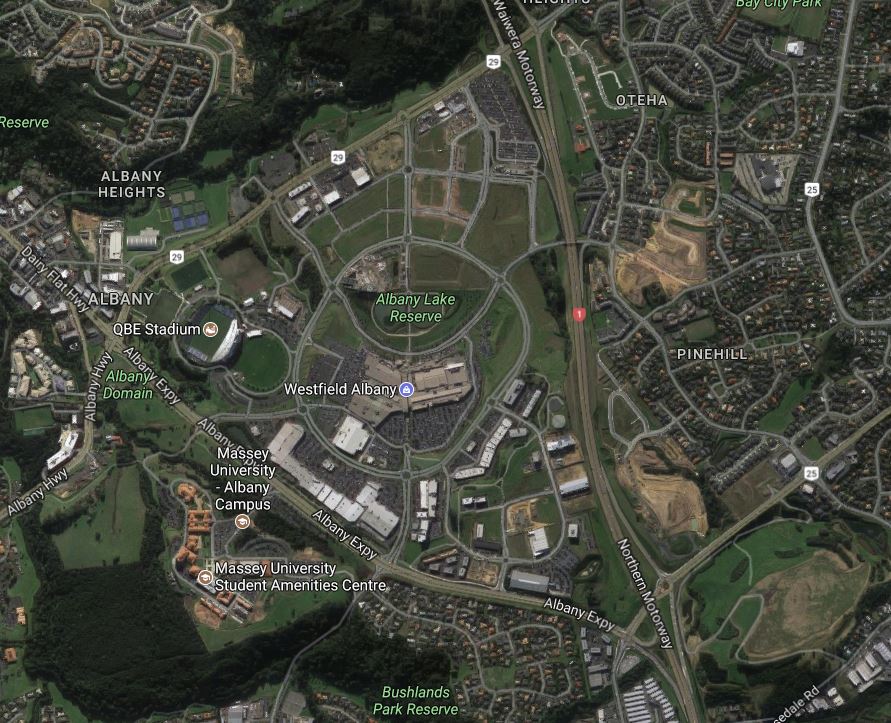
Albany – a stupid loopy street network means it’s still undeveloped after 20 years
- Westgate is little more than a big box retail outlet with some pretty pavings, and probably won’t become much more than that for the foreseeable future. It doesn’t even have a semblance of rapid transit and probably won’t for about a decade. Probably most famous for a very critical Auditor General inquiry and an empty mall.
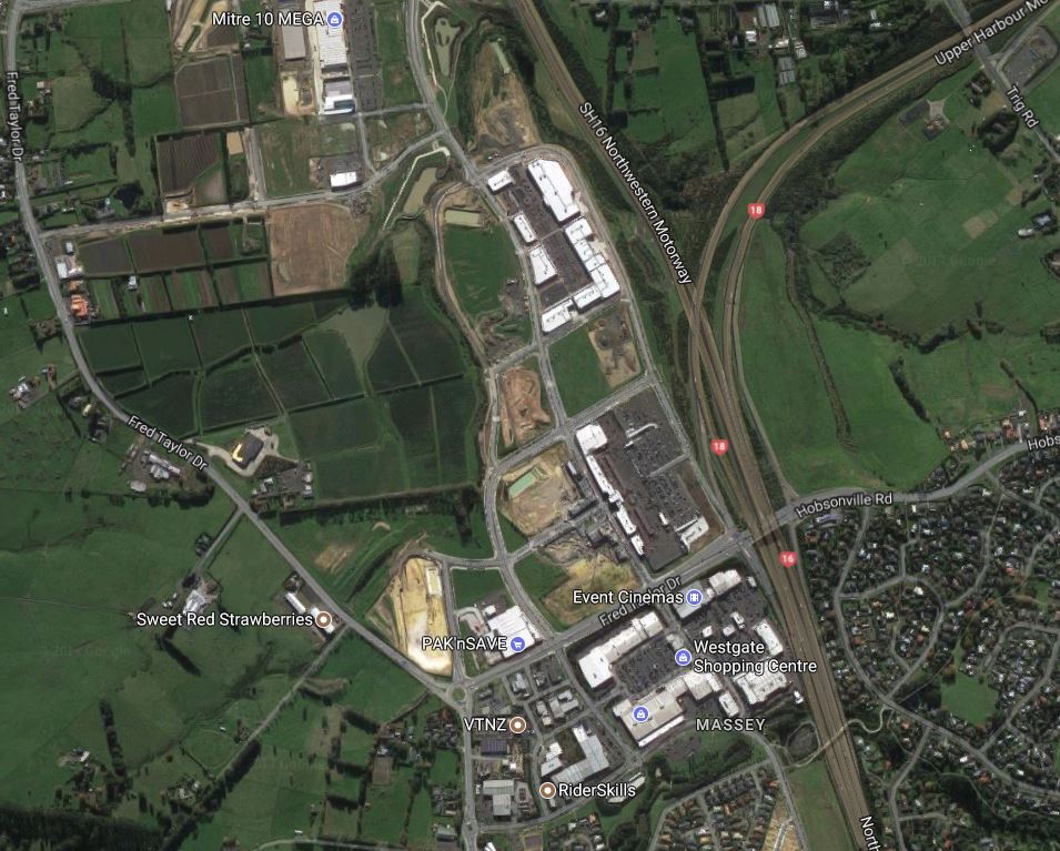
Westgate – motorways, carparks and big box retail. Not even a quarter built and already ruined.
Surely neither of these places contribute to the vision of the future we want for Auckland, unless they are to radically change. For starters they’re not really viable development places on their own. Just look at how long it’s taken for Albany to develop just to it’s present poor state. They’re remnants of pathetic late 20th century planning that made everything subservient to the car which goes against other goals for the city. While they link closely to major greenfield growth areas in the future, we must remember that most of Auckland’s future growth will happen in brownfield areas. It also seems strange that after investing so much in New Lynn, it seems the Auckland Plan is essentially abandoning it as a priority growth area.
If Westgate and Albany (and Manukau, to be fair) are to fulfil their potential as true “nodes” and become these second tier sub-regional centres, they are going to need to be radically changed from their current form. It’s hard to see how this is possible without massive intervention from the Council. Developers aren’t about to simply the kind of urban centres the council wants simply because of some lines and colours on a map. Perhaps Westgate hasn’t yet been completely ruined in the same way as Albany’s with its disastrous loopy street pattern, but there’s little doubt both will need a radically different plan from what’s currently happening.
Development Areas
The other new concept in the Auckland Plan is “development areas”. These appear to be the locations within existing parts of the city where the greatest amount of change is expected to occur over the next 30 years.

Picking some winners in terms of where to focus efforts in enabling large-scale change is sensible. I would imagine that the new government would focus on these areas for their KiwiBuild programme or where Urban Development Authorities might end up playing a major role. Which is why, when you look at the maps and sequencing of them, it’s a bit weird how small and constrained the Development Areas are and also how some key growth areas are pushed out from being immediate priorities.
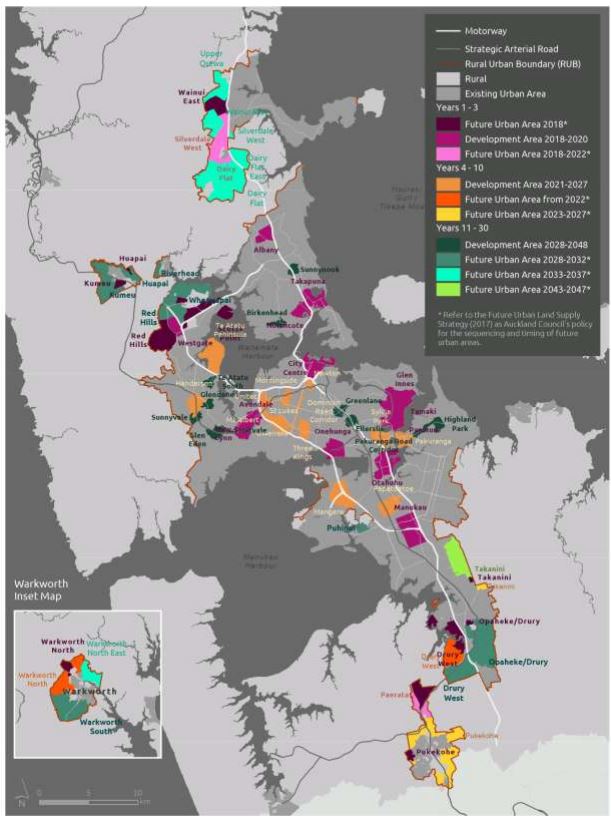

A whole bunch of nonsensical issues emerge with the map and sequencing table:
- Surely if we’re going to be spending billions on light-rail from the city to the Airport, and from the city to Westgate, whole swathes of land along these corridors need to become Development Areas, not just a tiny little line along Dominion Road and little else.
- It seems weird that the “Inner West”, which was a 2015-2018 priority in the previous Long Term Plan, now takes a “3 year breather” before once again becoming a priority from 2021 onwards.
- If Albany, Manukau and Westgate are to truly become “nodes” then they will surely be the focus of development for the entire 30 year period, not just the first three years.
- Same for the city centre
- Newmarket has strangely dropped off the list
- The only growth areas south of Manukau are greenfield areas, what happened to Manurewa and Papakura?
I will take a look through some other parts of the Plan in the coming days and weeks, and next year we’ll help guide some submission points.
From first blush it seems that quite a lot more work is needed to get this right.

 Processing...
Manurewa to Papakura were approved for their Area Plan yesterday. However, much of the goals in that document are unfunded and most likely to remain that way as the AP refresh didnt consider the area to be a priority until Decade Three (2032-2042). Something our Ward Councillor might want to pull finger on.
It seems the table above isn’t lining up with the Panuku Program given Manukau is under a major transform project that will last thirty years – something that will need to be corrected in the consultation stage.
Any way Manukau will evolve in its role as a node (or Super Metropolitan Centre) so we can relax there.
The other two has me interested although Westgate might just work if the Northland Regional Development fund gets the North Auckland Line going again and Kumeu establishes a small logistics base next to the rail line. Think of it as a mini Wiri. Westgate would then support Kumeu as Manukau supports Wiri.
To me one of the more stupid aspects of what is proposed is the plan to develop housing around active airfields, notably around Whenuapai and Dairy Flat, as part of urban sprawl and with it seems little thought to the inevitable noise complaints from future residents.
Yes, like the people that move to Mt Eden then try to shut down the stadium…
Yes – The residents around the Mt Eden stadium should be paying a levy added to their rates to subsidise the cost to Auckland, as they refuse to allow more events at the stadium!
And to complete the set, housing currently under construction near Ardmore. I assume the resident Harvards will be sure to do circuits during real estate open days.
Or Western Springs. But apparently it it works. I’d gladly live near Whenuapai – but my partner may not share the same enthusiasm for aircraft and historic racing cars as I do.
Housing choice is a key focus of the new Auckland Plan. They are promising a range of housing types from sedans for the busy one and two person households to sleep in, right up to people movers for larger family units to live in.
+1
Spot on. most of the land use in these ‘nodes’ seems to be for car parks. NZ culture is still racing headlong into the wrong direction. (Caaaa’s) I recently had a look around Westgate for the first time. It feels like a dystopian hellhole to me, much like Albany. Manukau is not much better. In these places I cannot detect culture, community, or any appeal to humanity.
Thanks Matt. The development areas are a bit of a concern. Stormwater and wastewater infra is something the AP needs to get right, too…
“Surely if we’re going to be spending billions on light-rail from the city to the Airport, and from the city to Westgate, whole swathes of land along these corridors need to become Development Areas”
I think the area around Stoddard road has huge potential. In fact I think that area could be the next New Lynn if the council put some effort in.
Does the overall plan align with the projected population increases over the same time frame? Some of these areas marked for development in 20 years time are being heavily developed now.
Seems the years 1-3 are just the current big time transport node spots bar Takapuna perhaps.
That aerial photo of Albany is quite devastating. What a complete and utter balls up.
It has barely changed since I first laid eyes on it 17 years ago.
I don’t know the background of the development, but it has a distinct whiff of cargo cult mentality. This is sad of course, since that land should be used somehow.
I guess that when LR runs to there, it’ll unlock some impetus to develop the land. Is it zoned commercial only? Wouldn’t be too bad a place for mixed retail / residential close to the mall.
It’s zoned as a metropolitan centre (basically CBD with an 18 storey limit) There are a whole lot of apartments going up at the moment, including several hundred apartments nearing completion at the Rose Gardens.
You mean those buildings at the top of Don Mckinnon Drive?
That would combine the disadvantages of apartments:
– not a lot of private space?
– where are you going to park your car?
and suburbs:
– soul-killing car-dominated environment outside
– is anything in that mall even open after 8pm?
Just… why?? I don’t understand this at all.
One step up from mfwic’s people movers is the tiny house on someone else’s land. Perhaps these apartments are one step up again. :/ Bring on some good brownfields development!
Yeah I had to look at that one for a while. How does it all fit together?
The university is separated from the shopping centre by not just an expressway but also its parking lot. I’m curious how students are supposed to reach those buildings. Pile on a little more student loan debt to buy a car?
The little parking lot looking sad and lonely in the northern corner is the bus station. Near-zero walking catchment. Not sure how people reach that station, apart from the handful of lucky birds who get a parking spot. Maybe that explains why we need all the “express” buses in that area.
Just to the west outside the image, there’s a more old-style shopping strip, which as far as I can tell doesn’t have any pedestrian catchment at all, and — surprise — generates the occasional article in the North Shore Times about people missing appointments because they can’t park anywhere.
The one part I occasionally visit are the mall and other shops. Despite the tons of tarseal they managed to make it surprisingly annoying to visit by car, due to the crappy layout of the accessways. The mall and the megacentre (the strip of shops backing onto Albany Expressway) are just far enough apart to rule out parking once and visiting both in one go. To give an idea, the distance between the centre of the stadium and the motorway is about 1.2 km.
But hey, apparently it’s considered a success, it’s so good that they’re doing another one in Westgate.
If you look at the most recent aerial images on google earth, there are actually a whole lot of apartments right next to Albany Village. Most of them from the last 5 years. That’s the walking catchment for that area :).
The rest of it is just awful though.
The location of node favour greenfield development over infill development.
If they really want more compact city, they should choose New Lynn, Takapuna, and Otahuhu instead.
The issue is infill development are harder. Because acquiring large sections of existing land is difficult as well as to deal with nimbly people.
Therefore in long term government needs to pass laws for Panuku to forcefully buy existing land at market valuation as well as making development a right instead of permission from Nimby.
I wouldn’t be interested in “forcefully buying” existing homes, but boy you could go a long way in rezoning to exclude the luxury car yards. Think of the possibilities on Great North Rd and Great South Rd… prime real estate, excellent transport and other amenity. I mean, surely the market for luxury cars is so small that they must be making enormous markups to be able to pay for those locations…
Strong compulsory acquisition rights -‘forcefully buying’ – are essential to solving this city’s housing mess.
regretfully there is almost total market failure, and there will need to be big intervention to sort things out.
It’s a pity because if the unitary plan or something equivalent was in place 15 years ago the market probably could have done much of the heavy lifting
Is that 2014 link the most recent North West transformation update? A lot has happened since then. I’m curious to know when this Northside Drive extension will be started.
Also close Maki Street outside the mall please. Drivers use it to rat race to the motorway and/or use it as a car park at night.
Henderson has always been the heart of West Auckland. Now they seem to want to move it to Westgate even they Henderson already has so much that makes a great place to develop. It makes the work supposedly being done by Panuku look like a sham. I thought there were also plans to make a full transport hub at Henderson in the near future too?
All good points – Council has yet to publish and consult on this draft so there is plenty of scope for submissions to (hopefully) improve the plan. Of course the development community will have their opportunities to submit as well but hopefully Council will stick to the “density done well” principle that guided the first version of the Auckland Plan 5 years ago.
AT are buidling a large stop for trains at Henderson as part of the CRL I believe
How does this work with Westgate I ask you…….
Henderson is a clear bettet choice in location and surrounding environment plus our heavy rail network is not being designed for Westgate
I live in Albany Village. Since the Mall went up the Village has nearly become a ghost town. I walk along Oteha Valley road to get to the Oteha Valley Albany busway station. It’s a fifteen minute walk. Walking along there, there is plenty of traffic but no foot traffic, I seldom come across anyone else walking along that road (most of that traffic I mentioned exits the motorway to access lifestyle blocks north of Albany as the most of it in the evenings uses the Oteha Valley rd extension) My apartment has a lovely view up Oteha valley road and across to the stadium. but I can see that alot of that land has been wasted by ring roads that seemingly take you to nowhere. It is a nice view but living here, especially after living in Parnell Rise for twenty-five years. I feel like, where is the humanity. There is hardly anyone around. And also there is nothing really much open around here after 20:00, esp for someone like myself who has no car. Also building all these new apartment blocks, including any future ones in this “node”, do we risk them becoming ghettos in twenty years if they are not maintained and if their owners rent them out instead of maintaining them and living in them themselves?
its up to the train not up to any one where it wants to go to and from