Russell Brown from Public Address took a ride out to Lincoln Rd the other day and in the process captured some of the immense works going on.
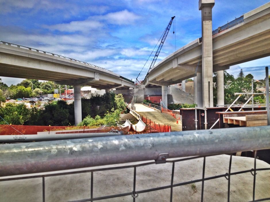
Head over to his post to see some more photos.
This also coincided with news that the project is now reached the halfway point with even the NZTA calling the new interchange “towering”
Construction of interchange ramps that will link the Northwestern and Southwestern Motorways (State Highways 16 & 20) when Auckland’s Waterview Connection opens in 2017 has reached the halfway point.
The last of the precast concrete beams were placed recently on the second and longest of the four ramps that drivers will use to get to and from the Waterview tunnels. The 500m-long ramp will be used by drivers traveling east on the Northwestern Motorway to access the southbound tunnel.
The NZ Transport Agency’s Acting Highway Manager, Mieszko Iwaskow, says the four ramps are on three levels and, in total, add up to 1.7 kilometres of viaduct structure.
“They make a very large project within the already huge Waterview Connection project.”
Mr Iwaskow says the ramps are taking shape above the Northwestern Motorway, one of the busiest sections of motorway in Auckland, with minimal disruption to traffic.
“This is thanks to the yellow self-launching gantry that is a familiar sight for commuters on this section of motorway as it travels backwards and forwards to fetch, lift and then place the concrete beams into place for the ramps.”
The gantry – named Dennis after a project worker who died of cancer in 2013 – eliminates the need for conventional cranes which would have had to be moved into place at the start of each work shift and then taken away before the morning traffic peaks.
“There is no doubt that Dennis is perfect for this job,” Mr Iwaskow says. “It saves time, reduces traffic disruption and avoids the need to use cranes in environmentally sensitive areas of the Oakley Creek estuary.”
Having constructed two of the four interchange ramps, Dennis will soon start work on the highest of the four ramps. It will carry traffic leaving the northbound Waterview tunnel towards the city centre and climb 22 metres above the ground at its highest point.
It is due to be finished by October, leaving just one ramp to be completed in 2016. The ramp that drivers coming from central Auckland will use was completed last May.
The team behind the project have also recently released a few new time-lapse videos. The November one showing them getting ready to relaunch the TBM
And the December one showing it starting the second tunnel as well as the ventilation building at the southern end starting to take shape.
And from the NZTA’s project page, here’s what the inside of the tunnels look like.


 Processing...
Great to see additional cycleways around this interchange – been a long while since I had involvement with this project during pre-consenting design, and it looks like provisions have got better as a result of whatever process the Council and NZTA have gone through. Well done all involved in recent design stages!
In addition to what is in the photos on the Public Address post, I noticed this week what looks like construction of a path base that might just cut out the need to cross Carrington Road, by routing under the local road, perhaps sandwiched between the bridge span and the top of the bridge abutments (retaining walls under the bridge). Can anyone confirm this? I was also confused by the photo on the Public Address post that showed a path on the north side of the existing loop of ramps adjacent Pt Chev. Anyone know how this connects on to the west? Residents were pushing for more connections of this type, hoping they got a result here…
Shoulda said this from the outset – once again I think we all CAA a big vote of thanks for their efforts on this one. Cheers!
Thank you – it took (and sometimes still takes) a huge chunk of our time, but it was well worth the effort for the various wins along multiple parts of the route. It also got us a couple new allies (even in NZTA, after the “at loggerheads” part was over eventually).
No that new path base seems to be for the off ramp which will start further back
http://www.nzta.govt.nz/network/projects/sh16-st-lukes-road-to-great-north-road/docs/Landscape-Masterplan-GNR.pdf
Connecting the cycle way under carington rd would also ease the grade on each side. The existing path through Unitec and wooden ramp, and the path over the bridge East of Sutherland St has several blind corners. Eliminating these would improve safety, along with the pedestrian crossing and on road section.
I believe some of the early studies or concepts may have shown the cycle way under carington rd. When I’ve asked about it, they’ve said there is not enough room under the bridge. Surely this is the time to make room?
This is one of the highest trafficked sections of cycle way. Given the spend on the yellow handrail section of the causeway, I can’t see why this is being scrimpted on.
Cycle Action Auckland did call for that path under Carrington Road as part of our submissions in 2010 (and in fact, even before that). However, all the space under the motorway bridge was already “spoken for” new motorway ramps, so we didn’t win that battle. We’re still trying to get the crossing across Carrington Road improved…
Impressive Engineering …..but…just not addressing the overbalanced car mode use ( in fact adding to it) or Aucklands problem. Just a hit in the wallet when we don’t have money or time to waste. The priority is train, bus, cycle, walking, ferry. Car gets benefit by other drivers choosing those other options when they are viable. A 30% mode share out of car will ease congestion on motorway and will continue to grow as our population increases and keeps more options open. Subtract from car mode creates a liveable and economic city, Addition to car mode share does not and it isn’t sustainable. Haven’t we learnt after 60 years of pushing a one cylinder solution. In short build the right things or don’t build them at all.
I’ve become more positive about this project as it’s progressed through to construction. The amount of tunneling has increased, while costs have gradually reduced. It will relieve pressure on CMJ and harbour bridge …
This project would seem to have the potential to leave a positive legacy if surface streets are drastically re-configured and down-sized. Appears to be a rare opportunity to use a massive amount of additional road network capacity as a catalyst for more complete, multi-modal surface streets in the wider area.
Does anyone know much about whether these plans exist or not?
How about closing the Woodward Rd level crossing once the tunnels open? One the motorway goes through it won’t be necessary as people stay on the highway, and this will save ratepayers money for the CRL project and all the bus users on New North Rd time as the traffic lights could almost drop a phase.
How about grade separating the Woodward Rd crossing since your hoped-for reduction in movements will likely be offset by the increased delays to road traffic caused by increased train frequency. That way the locals can still get to the shops.
Please don’t tell me we can’t afford it. AT have budgeted for it altho’ who knows when they’ll actually do it.
Auckland’s rail network will not be complete until there no at-grade crossings.
Peterc are you sure AT have budgeted for level crossing removals? There’s nothing in the LTP budget documents and they go out to 2025.
I recall seeing something about grade separating the St Jude st crossing in Avondale, but that may have been scrapped since.
How many locals are we talking, and presumably you mean to Pak’n’save once or twice a week? Going up to Mt Albert bridge is not much of a detour for that number of trips.
In any case I’d be interested to see the design and budget for a Woodward Rd underpass or bridge. It is close to New North intersection and there are driveways right up to the crossing on every side. It looks like you might need to buy these properties and cost benefit would be questionable vs just closing the thing.
Closing it [with ped/bike bridge] would do wonders for the residential community off the road as it is a short cut between N North + Carrington Rds. Make it into a much quieter residential island…. It would also improve the Richardson Rd intersection a great deal, but add traffic to the Mt Albert shops N North/Carrington Rd area. Unless Waterview really will remove a measurable amount of through routing here?
Has anyone done any work on this? AT? What are the expected impacts on the existing surface road network of completing the WRR? Hopefully there are some real wins that can be banked; isn’t that why we spend these billions?
There was quite a bit of Waterview modelling done, including the local arterials effects – but I understand that planners don’t really trust it, as the base situation has already changed quite a bit from what the model assumed, even before the motorway opens. The best bet is that some local arterials north-south will see a bit or quite a bit less traffic in the area, but nobody knows closely how much the drop will be. In the long run, traffic overall will rise again unless we then change these roads to have less capacity.
‘In the long run, traffic overall will rise again unless we then change these roads to have less capacity.’
Yes, unless AT take the opportunity to down tune them….
By down-sized you mean converting to bus/bike lanes, right? Not getting rid of valuable transport capacity overall?
An absolute eyesore on the landscape, with all the charm of an open cesspit or a giant wreckers yard even when finished (cue the endless flax bushes and ground up tree bark). But it would be awesome if I woke up in 1955 and knew no better!
Yes, of course. It is so bad to show the immense capability of man. Let’s just build little hobbit holes rather than constructions of epic size and scale. Why? Because we can. Homo sapiens sapiens.
It’s a motorway interchange Maths, not the bloody Pyramids of Giza!
Pyramids less useful than a motorway interchange. You realise they are just big tombs right?
ah ah without the pyramids Egypt would be as famous as Mauritania.
“Any intelligent fool can make things bigger, more complex, and more violent. It takes a touch of genius – and a lot of courage – to move in the opposite direction”
Unbiased multi- modal solution. No. One bus lane that you can wind up with more capacity .. No …versus numerous lanes that will choke somewhere in the short term. Ugly, noisy, not a green solution or even a smart solution. A complete engineering lemon with some token cycle connections. I’m just glad can’t see or hear from.my house, but I guess still in backyard for all Aucklanders and shit loads of asphalt that needs resurfacing every 7 years, more noise and more cost. Yah a bigger share for road maintenance. I wander what the bitumen price will be then, when they completely have the travelling public by the balls. Skinny solutions good, fat, ugly, wide need to go on a diet before a heart attack.
I am somewhat appalled by the height of the highways in the sky – regretfully so dominant visually and will probably be very dominant audibly when in full use. Please tell me I am wrong!?
Yes indeed absolutely no sound barriers so the noise will be broadcast across Pt Chev and Waterview. Can’t spoil the view for those in cars Huh.
Why is the transport industry complete puppets of the.petroleum industry? Smarter , and a wide range of transport modes have been around a long. long time? Time to cut the strings, send off Virgil and Scott from the Thunderbirds in the right direction for a change. Engineers cut the strings yourselves you are.being controlled by the petroleum industry at the.peril of the Earth and at the very least smarter transport and a better place to live. Transport affects the amenity of a place, public domain , character of corridors. Is more reliance on road width, and low capacity options smart in a city? Isn’t higher capacity and.more space for active modes the way to go?
Would of prefered thd CRL and it would of been done by now.
Agreed. In particular heaps quicker for western line. All this rubbish vs that?
I felt some unease when I saw those pillars starting to rise last year and what they would mean for the landscape. They look like highways to the sky. LA here we come.
They sure are imposing. Sad, really.
ACDC song “Highway to Hell” springs to mind. I’m glad this is going to fix congestion for everybody until you hit the first set of lights. Seriously do you need any of it if there were 2 lanes barriered off for a rapid busway like northern busway. Then you have 20 odd minutes coming off train trip after CRL. The thing I dislike is that the busway should have been the focus before doing anything, but no let’s widen the belt but go on a diet later when we need to ? isn’t that now? Congestion costing $1.25b per annum.
Rapid transit is a proven success but motorways are a proven disaster. Network resilience, more choices for everybody, and less required road width. The government doesn’t want to do those because car mode only approach is propping up the entire transport industry, but not the public, environmental side, or even truly helping car or truck really. Less traffic more flow and less petrol and less road construction.
.
What happens when the first truck falls off the ‘highway in the sky’ in a manner similar to this morning’s accident at near spaghetti junction. Seems it will be a long way to fall………………….
Exactly my point Maths. The Pyramids were designed just to be a grand edifice, a show of wealth and power. A motorway interchange is a practical thing, which should be as small and low impact as possible.
Or are you really suggesting we should have bulldozed more homes and squeezed on more schools to make it uneccessarily big and grandiose, because we are humans and we should build everything epic just because we can?
I realised slightly too late (after whipping out that E.F. Schumacher quote) that we’re being trolled here.
Them geniii at GenZed have just added this beauty too:
http://www.buzzfeed.com/ryanm468bfc780/8-taylor-swift-gifs-that-explain-why-skypath-will-xv94