The prioritisation of car movement over other modes has had a major negative effect on Auckland’s urban landscape. Streets have become focussed on their movement function, to the detriment of their place function. This has negatively affected the ability of anyone not using a car to get around. One area this can be seen is the minimal amount of pedestrian crossing facilities on any road deemed an ‘arterial’. I have discovered few especially bad ones recently to highlight this.
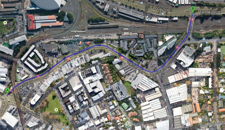
The section of the Strand from Parnell Rise to Tamaki Drive has no crossings. While this is the major truck route to the port, there are several large apartments on the north side of the road, and major office and retail on the south side near St Georges Bay Road. Also Gladstone Road (right side of picture) leads to Fred Ambler lookout and the Rose Gardens which are the local parks for people living in the area. So walking down here do see quite a few people rushing across the road dodging the busy traffic.
Manukau Road between Ranfurly Road and Greenlane West is a 900m long section with no crossings.

The Coast to Coast walkway even passes along the halfway point here, heading east from Mount Eden, down Puriri Drive towards Cornwall Park. This is supposed to be a major tourist attraction to show of Auckland’s varied suburban landscape, so lacking a pedestrian crossing here is totally hopeless.

Along this 2.4km section of the Ellerslie Panmure Highway there are only 2 mid block crossings, giving a 800m spacing between crossings. Making things even worse is there isn’t even a painted median along here. On the two roads above the braver citizens could at least wait in the median hoping a car wouldn’t choose to use the median at the same time. However on Ellerslie-Panmure it is almost impossible to cross without major danger.
Clearly there are several reasons why our roads need to be more pedestrian friendly. The purpose of these roads shouldn’t just be to move traffic across town as fast as possible. They are also walking and cycling routes to local shops, schools, parks and community facilities. Not having any crossings makes it more difficult to access these shops. While some more agile people can run across the roads, this is rather dangerous. However for children, those with limited mobility, such as the elderly, wheelchair users and those with prams, not having crossings is a terrible barrier.
Access to public transport is also another very important factor. Both Ellerslie Panmure Highway and Manukau Road are major bus corridors, and key parts of the future frequent bus network. Every bus passenger is a pedestrian, and will need to cross the road when either leaving or arriving at their origin and destination points. Not having any safe crossing points could put people off catching the bus, and could prevent parents allowing children using the bus for example.
So what needs to happen? Auckland Transport need a major programme to identify areas where there are large gaps. The ideal bus stop spacing is often seen as around 400m, and each bus stop really needs a pedestrian crossing nearby. So this spacing could well work as a rough guide to spacing along major bus routes. However this of course could change dependent on local conditions, such as to allow access to schools, shops and parks.
As we have mentioned Auckland Transport has being going through a process of preparing Route Optimisation. However unfortunately this has been focussed on increasing throughput of vehicles, sometimes to the detriment of pedestrians and buses. A much broader approach needs to be taken that is truly multi-modal which will increase accessibility, safety and overall help make our streets better for all users.

 Processing...
Excellent points made. It is truly sad how badly Auckland treats its pedestrians – we desperately need to change this.
What’s crazy about this is that every car user is at some point a pedestrian. You can’t always park outside your destination. So not only is this state of affairs bad for ‘full time’ pedestrians and PT users it also causes inconvenience and danger to car users!
Living on Gladstone Road my partner often walks along the Strand towards the University. She says the pedestrian environment is made even worse by the fact that much of the footpath on the Parnell side is taken up with parking for the garages/shops along the road. I sometimes walk the other way to Tamaki Drive, crossing at the point marked B in the photo. In the mornings the constant stream of traffic turning left off Tamaki Dr onto the Strand at high speed combined with the lack of pedestrian crossings on the slip lanes makes it difficult to even get to the island to wait for the signalised pedestrian crossing.
The Strand is incredibly hostile to cyclists, too, largely because of the lack of pedestrian facility. Sure we can use the traffic lanes, and everyone is very cautious at the moment, but if you want to turn right you can be left hanging in the flush median for a heck of a long time before there’s a safe gap in the traffic. Can be quite scary wanting to turn right up Gladstone Rd in the evening when you can’t see a whole lot beyond the hump, so just have to pray that there’s not somebody in a car with their foot down coming around the corner.
I used to work in this area and walk down The Strand every day. The businesses along there treat the footpath as their carpark/car washing area. Some have generously painted a yellow hatched area to indicate that this is ‘reserved’ for pedestrians.
My colleague, who biked through the back streets of Northcote, caught the ferry and then rode along the shared foothpath to The Strand, dismounting at the lights and crossing at the pedestrian crossing, managed to get bowled at the Gladstone/The Strand intersection at that high speed ‘slip’ lane by someone not giving way and spent 6 months off work recovering. He was wearing a hi vis vest (not sure if he had a bell).
An appalling part of town. But you could pick just about any street in this city and find ridiculous hazards for pedestrians that could so easily be fixed.
One of the tools traditional traffic engineering uses to push cars above everything else is “Level of Service” (LoS). A letter grade that shows how effective a road is at moving cars, and there’s an endless quest to get a better grade for cars at everyone else’s expense. We need a similar “Level of Service” for pedestrians, which would measure actual walking time compared to how long it would take to walk without stopping.
For motor vehicles, LoS “F” – the lowest possible grade – for an intersection is (I believe) anything over 80 seconds average intersection delay? Well, most pedestrians face that or worse trying to cross any of these major arteries, even if you get to take a direct route. It’s worse crossing diagonally: you have to wait for two phases, whereas cars would have had a dedicated right-turn phase. If you have to take a detour of several minutes simply to get to a crossing in the first place, that’s a LoS which is well below anything that cars ever face. LoS Z.
Can’t agree with this more. I live in Ellerslie and use the Ellerslie Panmure Highway frequently. The way it twists and undulates is dangerous for traffic and pedestrians – if you tried to walk across the road you could quickly find a car bearing down on you from around a corner or over a brow of a hill.
And while not as terrible an example as the EP Highway, there is also bad disconnect in the same area on Ellerslie Main Highway – no proper pedestrian crossings all the way between the EP HIghway lights and the middle of the Ellerslie shops, despite the pedestrian traffic to the petrol station, wholesaler, daycare etc, and then the eastern end of the shops. Accidents waiting to happen everywhere.
Agree. And as mentioned elsewhere, the newly completed panmure train station lacks pedestrian connection to the south side of the ep highway. bad luck if you live in Ireland rd.
Port representation has a lot to answer for. Setting aside debates on the port location, trucking should not determine road priority in this part of town. It is the CBD, and truckies / port operators need to accept that they drive to the conditions associated with a CBD. Omitting crossings is not acceptable when there are lots of people on foot, just to save a few precious seconds for trucks. No negotiation. Beach Road / Tangihua is a disgrace to AT.
simply trucks should be banned from Tangihua st. They should just use the strand to get to the highway.
It’s not just about having crossings, it’s also about them being usable and useful. A friend and his family live right adjacent to the Main Highway T-intersection at the motorway end of Ellerslie (about where the left-most end of the blue line is drawn), on the southern side of the main road. His wife has timed a wait of 12 minutes for the pedestrian phase to come her way when trying to cross between the northern and southern sides of Main Highway (it doesn’t become Ellerslie-Panmure Highway until east of Michael’s Ave). 12 minutes!
Imagine the outrage, the red lights ignored, the letters to the editor, if motorists had to wait 20% of an hour to get a green light.
That Manukau Road section would be so easy to improve. Put a few breaks in the raised planted median for a pedestrian refuge (which it already gets used for, unless you have the misfortune to be pushing a pram, in which case the kerb and bark would be horrible to navigate), and some traffic slowing measures to stop cars hooning down like a defacto motorway. Or go the whole hog and add a few on demand signalised crossings.
Pedestrian LOS tools exist already. More interesting is that many big cities are moving away from LOS- Washington DC, San Francisco, and Chicago for example. In Chicago they require that no pedestrian delay exceed 60 seconds! They of course have intersections and ped crossings to start with…
There’s good work on pedestrian LoS for flowing traffic (i.e. space per person) that I know about – is there something for intersection delay as well?
San Francisco is a good achievable example of where central Auckland can get to very easily from here. It still provides for a lot of driving, in a very car-oriented region, but hasn’t sacrificed pedestrians to get there. It’s a question of emphasis – should the city actually provide for everyday activities for people outside of a car? Or is it more important to turn a 8km tailback into a 7km tailback?
Yes in the 2010 Highway Capacity Manual- this includes a scoring system based in intersection delay (signalised and unsignalised intersections)
Kent, any chance you could post a summary of these levels and how they’re applied (ie. how strictly and when)?
Of course, right here in NZ we also have LOS measures for pedestrian crossing delays in the NZTA Pedestrian Planning & Design Guidelines – see http://www.nzta.govt.nz/resources/pedestrian-planning-guide/pedestrian-planning-guide-index.html. Section 6.5 indicates that an average crossing delay of >40s should be considered LOS “F” – how many places do you think that might apply to in Auckland…?
There’s also a lot of other good stuff in the Guide about best practice provision for pedestrians – of course the trick is to actually get it implemented…
Very good post, Luke. It’s particularly concerning how dirt cheap at least some of the improvements are, yet they still don’t get done. Let along someone tackling the thornier issues like the Ellerslie Panmure Highway’s disgrace for walking and cycling.
The other nasty thing they do is have crossings that lead to an island where you have to doge a lane of traffic to get to the footpath. Symonds St / Khyber Pass intersection outside the cycle shop is really bad when crossing with kids. There’s pedestrian lights that get you to an island where you have to somehow get across the left turning traffic lane to actually complete the crossing.
I have to cross here regularly and it really is a nightmare! You often have to wait for as long as another signal cycle which is very frustrating. Also most drivers there don’t seem to signal their turn, so there is no way of knowing until the last second whether it is safe to cross.
This is even more frustrating if you are using the shared path to bike – hence why people cycle on the road, which is often a big complaint for motorists (ie “why don’ they use the shared path that’s built for them”)
I agree. The Ellerslie Panmure Highway is a shocker. As Luke says this is a major bus corridor and the lack of pedestrain crossings (and bus lanes for that matter) make it a very unfriendly road. I know that the Orakei Local Board is looking at improving pedestrian crossing facilities along the Ellerslie Main Highway and village but I can imagine that, like what Steve D says above, the Level of Service for cars will mean that all road users will not be considered equally and the crossings will be placed in such a way as to minimise disruption to those travelling through in cars. Auckland Transport’s needs to understand and lift it’s game in Place Making.
Great post. This phenomenon isn’t just an isssue for the suburban arterial “highways” like the EP Highway or Manukau Rd (which shouldn’t be a highway in any event). There is also a disgraceful lack of consideration for pedestrians in the CBD, where there are tens or hundreds of thousands of pedestrians every day. I have commented a number of times on this blog about the Shortland Street area, which alone has thousands of people working in office towers (most catching public transport). Everything west of Queens St is a disgrace (Albert St, Nelson St, Hobson St) as are Mayoral Drive and Wellesly Street (where some of our most important public institutions are located). Again I ask, why is the downtown area set up to cater for the small proportion of people who can afford to drive into the city as their primary means of transport?
Yep agreed about CBD, got a few in the works on that too. But also good to focus on the suburbs sometimes too.
Yeah, I defnitely agree with you that the suburbs need some attention too. Just yesterday I commented about the need for increased cycling amenity in the suburds to allow people to get around their neighbourhoods without driving, and pedestrian amenity in these areas is just as important. It is also so important for suburbs like Epsom, Mt Eden, Sandringham, Ellerslie, New Lynn etc that are crisscrossed by major arterials that there are some measures to stop the dislocation that they cause.
Wellesly Street is horrible. I often cross to grab lunch at the City Works Depot (which I wish we could put on a carparking diet, but that’s a rant for another day) and it’s like playing dodgems with cars turning from Hobson and then heading down the hill at speed. What with Telecom/TVNZ in Graham and Hardinge Street along with the new tower that’s being built, that’s a decent bit of pedestrians.
Couple shockers down there indeed – the intersections of Wellesley Street West with Sale Street and Drake Street could be reduced to half their size tomorrow with pop-up pedestrian plazas as in New York.
This problem exists on Most NZ cities
Hamilton is making some progress with road crossings, I like to think this is a good example.
http://www.hamilton.co.nz/our-services/transport/safetyaccessimprovementprogramme/Documents/2013-14%20Proposed%20Works%20PDFs/11.RIVER%20ROAD%20PEDESTRIAN%20REFUGE%20ISLAND.pdf
These about half a dozen of this type of pedestrian island crossing plan for Hamilton this year. hopefully more next year.
Well, sort of – still gives priority for cars (but agree they are a big improvement).
Interesting to see the way they treat the cycle lane. Would be interested if this is working out well for them (Council and cyclists).
Wellington is pretty bad, too, once you get off the “Golden Mile”. Plenty of CBD arterial intersections have a pedestrian leg missing, at least one doesn’t even have a pedestrian crossing on the main road at all, even though the side street has a signalised turn.
Perhaps the worst intersection in the country is in the industrial/big box retail area of Ngauranga, which is directly outside a railway station and has bus stops on both sides. There’s a giant signalised intersection that merges the Hutt Stroad with SH1 and SH2 on/offramps, and a local street. There’s simply no pedestrian crossing at all, on any of the legs. In practice, there’s simply no safe way at all to cross: you could catch the train or bus to work in the industrial park at Jarden Mile, and… nothing. You could walk 1.6km (!) to the nearest crossing, and it still wouldn’t help, there’s no footpath on the opposite side, and not even a shoulder to walk along. It’s traffic, then a sheer cliff.
It’s amazing, because there’s trains and buses that stop there! How does anyone imagine that those passengers actually get anywhere? You have no option but to dart across four lanes of 80km/h traffic.
Yes, that intersection is quite terrifying to contemplate. That said, the dislocation and inconvenience caused by the Ellerslie/Penrose interchange is pretty staggering. It’s a hell of a long walk/bicycle to get to the nearest pedestrian corridors over the motorway, especially if coming from around Greenpark Rd onto GSR.
Ngauranga railway station is the most poorly-used on the network, the least publicised and consequently the least known-about. And for a long time it was also the most neglected. The motorway embankment has effectively cut it off from view of anywhere else and resulted in a tortuous 150m detour for pedestrians (=passemgers)to access it from the nearest road. This access regularly used to flood to a depth of 75mm during wet weather, though this may have since been fixed.
Once upon a time there was a hole in the fence and users could simply cut across the northbound track to get to the platform, but these days the rail corridor is deemed “dangerous” so the shortcut has been closed off.
But the real danger is the roads that must be crossed to access this station from anywhere, including that horrible intersection. On account of the hostile accessibility due to roads, Ngauranga has to be the most user-unfriendly station on the network. And I know of no plan to do anything about improving this. In fact given what has recently happened to Kaiwharawhara Station (closed because expense could not be “justified” to fix the footbridge), this even lesser-used station may suffer a similar fate. But under better circumstances it ought to become a thriving hub of access to the nearby business parks (along with a similar station-stop on the NIMT as well, serving the Glover Street area).
Yes, the gap between what’s there and what it could be is just so massive. For somewhere with the rail and bus access that it has, it’s incredibly hostile trying to access via public transport and impossible to walk around once you’re there.
The location itself is wasted, really. It’s a huge choke-point for traffic going between Wellington City, the Northern suburbs, Porirua and Lower Hutt. It’s almost the centre of gravity of the whole region. But there’s little there to cash in on the passing cars, other than L.V. Martin if that’s even still going, and there’s no effort whatsoever to integrate the public transport services or allow any interchange.
I think it was once an abbatoir site, and it’s never going to be, say, Petone. It’s mostly just drifted into the current state. But someone made the deliberate decision to build the traffic lights like that, probably in the early 80s when the SH1/SH2 interchange was built.
At the very least, just to get from the current awfulness merely to being mediocre, the intersection itself needs pedestrian crossings, and a more attractive and obvious connection to the station.
At least there are some marked cycle lanes through the Ngauranga interchange. Haven’t heard of any cyclist issues there, which is something I suppose.
If you get to that intersection on a bicycle, you’ve already successfully ridden through 80km/h traffic to get to it, and you’ll be soon going up the gorge or along the awful SH2 cycleway – only the truly elite road warriors would ever be going through there. I image they’re probably relatively happy, compared to other parts of the route.
These kind of pedestrian crossing islands should be standard practice and are included in NZTA’s “Guidelines for Flush Medians”. Page 11 of this guide notes “solid pedestrian refuges should be located at points where pedestrians are generated.
Refuges are especially necessary where pedestrian usage is high, and at pedestrian crossings. Where pedestrian usage is spread along the median refuges should be constructed approximately every 400 m.” For whatever reason this guidance is not being followed as I know of a number of locations where flush medians have been newly painted but no provision for pedestrian crossings have been made.
‘refuges’ is such an appropriate word in this situation. Risk life and limb and make it to the refuge before the final assault to the other side.
I used to live in Waterview on Great North Road, there was a bus stop in front of my house and one across the street, convenient right? No, to get to the bus stop across the street I had to spend 10 minutes walking up to the closest crossing and back down again (often while watching buses I could be on zoom past). There needs to be at least a pedestrian island, but preferable a striped crossing close to every bus stop.
yeh that section of GNR a real shocker, could have easily used that one too. Looks like 750m between Alford St and Blockhouse Bay Road. Again have a bus every few minutes along here, but very busy traffic so very hard to cross.
This isn’t quite as bad as Ngauranga, but have you ever tried to walk from Sylvia Park Road to the Sylvia park shopping complex or Sylvia Park railway Station? This involves crossing the 6 lane width of the Mount Wellington Highway and an on-ramp and off-ramp onto SH1
The intersections/light phases give no level of service to pedestrians and most traffic is accelerating/decelerating to/from 60km/hr or higher.
The lack of pedestrian access means that the shops on Sylvia Park Road appear to be economically undesirable,
Lloyd – I have posted before about this, that part of Auckland is almost suicide to either walk or bike through. There is a surprisingly large number of people employed on Sylvia Park Road, and given the short distance, especially those at the eastern end should be able to go to the Sylvia Park shops easily for lunch etc. But no.
The Mount Wellington Highway motorway underpass is extremely narrow, no shoulder room for cyclists, and pedestrians have minimal room either. The danger involved in this run means I don’t go to Sylvia Park on my way home from work, and the retailers there miss out. I can’t be the only one.
@Lloyd: That’s pretty bad. Take your chances with three lanes of traffic at a time, go all the way south to Panama Road, or go all the way around to the walkway along SEART? You’re adding a couple of kilometres, either way.
Ngauranga probably isn’t the absolute worst place in the country to be randomly dumped on foot. But located where it is, next to a rail station with pretty decent service, and quite a bit of employment on the other side, it’s somewhere that people might actually try to use. That part of Mount Wellington Highway is awful too, for similar reasons, and perhaps even harder to cross without a crossing. But I don’t think it would occur to many people to even try to make that trip: easier to get to Westfield station instead, and for the buses, walk to Panama Road.
These sorts of horror simply shouldn’t be in the toolkit that traffic engineers have available to them. It should be just as unthinkable to build a urban arterial road without regular pedestrian crossings, and footpaths on both sides, as it would be to have it be an unpaved mud track. When a traffic engineer’s boss tells him that a plan is too expensive and asks what can be cut – getting rid of the footpaths and pedestrian crossings simply shouldn’t be part of the reply, any more than he would suggest getting rid of stormwater collection. If you can’t afford to do it right, drop some traffic lanes, or don’t do it at all.
Still, as I understand it, this particular nastiness should be improved from “nightmare” to “average” with the Sylvia Park section of AMETI, which puts a footpath along the western side of MWH, so you can walk to the crossing outside Sylvia Park mall itself.
Pedestrian crossings are not needed as people are permitted to cross the road anywhere along its length, with a few very small exceptions. I live in busy Swanson Rd, where pedestrian crossings are at roughly 2km intervals, but nobody has any issue with crossing the road, as it’s permitted along its full length.
It would be a nonsense to have port traffic movement stuffed up by having the odd single pedestrian causing 20 vehicles to stop, with the ensuing run-on congestion. JUst one person every 5 minutes and the STrand would turn into a major problem area for traffic.
We should be focussing on making transport smoother, not finding ways to make it worse.
Why should that be the focus?
In the world according to Geoff, the focus should be on doing what NZ’s transport planners have done so well for the last 60 years: moving the greatest volume of motorised vehicles at the greatest possible average speed.
Apparently not, according to one who would know, it’s all in the traffic lights
http://www.nzherald.co.nz/opinion/news/article.cfm?c_id=466&objectid=10879979
Yeah, you tell my partner that she should just suck it up when she’s out walking our infant son in the stroller. Not everyone is able-bodied, and not even everyone who is able-bodied is in a position to dart nimbly between vehicles. A lot of people find it very scary to have to try and engage in such behaviour.
We should be encouraging pedestrians and cyclists, because getting people out of their cars is good for congestion, good for their health, and good for the economy. If that’s an inconvenience to motorists, well, too bad, because the evidence is that it’s people who buy stuff, not cars and trucks.
“We should be focussing on making transport smoother” – That is the focus – the smooth transport of PEOPLE by foot or bicycle.
What you want to focus on is the smooth transport of as many cars and trucks as is possible, regardless of its effect on human beings on the same piece of roading. You should come and live in the 21st century, its really quite nice here.
@Geoff: That’s good enough when roads aren’t that busy, have good visibility, and aren’t very wide (or have refuges). Swanson Road is one lane each way, right?
But in urban and suburban Auckland, plenty of roads have multiple lanes each way, including all of the examples in the post, at least in peak time. It quickly becomes impossible to cross the road when there’s limited visibility due to corners, or significant traffic, or cars are moving upwards of 50km/h.
The important question you’re ignoring, though, is “worse” for whom? You clearly think that smoothness only matters for cars and trucks – but having to make huge detours or indefinite waits makes walking a hell of a lot less “smooth” for people on foot. If that pushes them into not making trips at all, they’re losing out, and if it pushes them into driving instead, that’s going to be way worse for the almighty traffic flow than if they were walking. Especially if they replace a short walk to the shops with a long drive to the mall.
A touch dishonest Geoff, Swanson Rd had two pedestrian refuge crossings in front of the train station, a third by the bus stops and a full zebra crossing at the primary school, then a fourth pedestrian refuge crossing. That’s five crossings over 750m in the village. Yes it thins out on the sparsely populated middle section, then more crossings at Ranui.
So The Strand is just under 1000m long. So why does Swanson Rd get five crossings while the Strand have zero, at that rate The Strand should have seven. I know which road has more people walking along it, I know which neighbourhood has more people living in it. Rather than saying “tough shit” why not advocate that other neighbourhoods get the same treatment as where you live?
wow
I said pedestrian crossings Nick – One pedestrian crossing at Swanson school, then 2km to the next one, at Ranui, then nothing until Larnoch Rd.
If the Strand needs crossings, they should look at an underpass or overbridge. But it’s important to bear in mind that the motorway is likely to be extended to the port at some point, so the Strand may eventually be downgraded to a local street, where much more focus on non-vehicler traffic could be made.
Geoff, You have already proven in past posts that you don’t care for pedestrians.
Wrong, what I don’t care for is suggestions that use catering for pedestrians as a guise for the real motive of making vehicle movements more difficult.
The Strand is an important freight link, and Auckland Transport and NZTA are currently designing an upgrade of the route from Stanley Street to the port, that is likely to have dedicated truck lanes and a reduction in intersections along the way. In other words, it’s going to be turned into a defacto motorway. At the same time, Beach Rd is going to be made more pedestrian and cycle friendly.
So suggestions of putting in pedestrian crossings along the proposed dedicated truck lanes should perhaps be modified to be in line with the primary purpose of this road, which is vehicle traffic. Pedestrians need to be kept separate, not integrated. Overbridges and unerpasses yes, at-grade pedestrian crossings no.
Geoff, I drive a car pretty much every day. I also walk as much as I can and ride a bike to the shops etc. Your opinion is pretty much always in favour of traffic movement above all else.
According to NZTA figures only 7.4% of the traffic there is heavy freight. It’s a bit of a stretch to talk about it as a freight mega link, 92% of the vehicles are cars headed out to Parnell or Tamaki Dr.
I’d be interested to know how they are planning to reduce the intersections along the way, given that there is only one that isn’t already a left in left out.
Bryce, my primary method of moving about is to walk. I generally walk around 10km every day. I avoid pedestrian crossings though, as I know it’s more efficient for both myself and for the vehicles if I cross further down the street when there’s no cars coming. Why stop cars at a pedestrian crossing when I don’t have to, and have to stop anyway because the first two or three cars won’t stop. There’s only two kinds of people who want to see more pedestrian crossings – physically impaired, and those who enjoy stopping cars because they don’t like them.
The issue is that you appear to only look at this with just your abilities as the guiding factor. As a driver, I have no issue with stopping for pedestrians and am sympathetic when i see roads where people have to scurry for their lives to get to a paint protected flush median. Also, it seems like a game for many motorists to treat pedestrians as road fodder. Most drivers don’t slow down a bit when pedestrians are involved and many are quite content to drive past at 50kmh, 1/2m away from another human being, seemingly total oblivious to the risk posed by their vehicle on a fellow person. I say this as someone who spends quite a bit of time working on or near roads.
I don’t give a fig about Beach Road. I care about The Strand, which is where I work. Myself and many others. Beach Road cannot get me to work. Upgrading The Strand and Stanley Street to “de facto motorways” is a continuance of the destruction of place in favour of getting vehicles through as rapidly as possible, ignoring that The Strand (and, to a lesser extent, Stanley Street) is a place. People go to places and do things. Cars go through places and don’t. The local business community will have nothing positive to say about any plan which makes The Strand even less friendly for anything that is not motorised through traffic.
I know you support such destruction, Geoff, but those of us who have a community investment in the destroyed places tend to be very much against such things. Funny that, because it’s our places that are being destroyed. Let’s run a de facto motorway through the front yard of your place of employment and see how much you clamour for supporting heavy vehicle through traffic.
Except Matt, the Strand is obviously the #1 link from the motorway network to NZ’s biggest import port. To regard it as a “place” for people to hang out, probably isn’t the wisest way of looking at it. If anything, it was very poor planning to cram hundreds of apartments beside such a link.
The fact is, it’s only going to get busier. Several parties want a whole new road built, either as a tunnel or an elevated highway, but the council has determined that upgrading the Strand to enable faster throughput is better, including dedicated truck lanes.
It won’t be an environment suitable for pedestrians or cyclists, so the best thing to do would be keep them off to one side with cycle lanes and pathways either side of the upgraded road, connected with underpasses or overbridges.
Nick, in regards to your freight comment. See the original press release behind the intent of the Grafton Gully motorway and Stanley Street-Strand underpass. The whole thing, IIRC, was to be part 1 of a 2 part project, with part 2 being from the railway to the port. Perhaps the next Labour government will complete the project?
http://www.beehive.govt.nz/node/12554
Geoff if the motorway is to be extended all the way to the port, this implies that the port will be re-organised for motorway use only, which is standard road engineering practice, so where will the port be moved to? Whangarei?
Umm Geoff that’s a thirteen year old link! Not exactly relevant. Yes it was a three stage project, stages one and two got built and stage three was a never never land wish list item, like the eastern motorway. If you could show me it on any current investment programme, long term plan, or even the thirty year strategy I might be convinced (don’t bother, I know it’s not there). That is one project that is dead and buried, like so many others due to huge cost and low benefits. Such a tunnel would cost about a billion dollars based on the per metre cost of the Vic Park tunnel, a billion dollars is a whole lot just to avoid having to slow for two sets of traffic lights.
Given there are traffic lights at either end of the Strand is it going to make much difference having the odd crossing along the road, which will give a greater portion of time to the route than those at either source or destination? Correct me if I have the engineering wrong, but for throughput I thought it was the bottleneck that causes the problem.
There are a lot of people working along the Strand, like at Saatchis. Even if you ignore their need to cross the Strand, that’s no excuse for the poorly designed intersections at St Georges Bay Rd and Gladstone Rd which could be improved without any impact on the truck route to the port.
There are no pedestrian crossings to speak of at the Onehunga end of the semi motorway that is Neilson Street. Very unforgiving travel place to be on foot
Did you know pedestrians may cross with traffic signals where there is no pedestrian crossing
3.2(2). While a green signal in the form of a disc is the only signal displayed, pedestrians, riders of mobility devices, and riders of wheeled recreational devices facing the signal may enter the roadway…
and a driver facing the signal must…
3.2(1)(b)(ii). give way to pedestrians, riders of mobility devices, and riders of wheeled recreational devices lawfully crossing or about to cross the roadway
Thank you!
You try wearing high heels and crossing the Mount Wellington Highway near SH1 across the turning traffic with a green light! Have your obituary organised.
Great post and some useful comments.
I agree with having refuge crossings at reglar intervals (say as close as 200 metres) down all arterial roads but signalised crossings only where there is either a significant pedestrian count or adjacent to a school, hospital or similar institution likely to generate crossings by vulnerable users.
As Transport portfolio-holder for the Albert-Eden Ward I will be looking this year at the “missing” crossings on significant pedestrian desire-lines – starting with our recently adopted Greenways plan. We already have a set of 3 refuges about to be installed in Morningside Drive but there are many other gaps in the network – thanks for highlighting the large gap on Manukau Road which is also in our patch.
We can put signalised pedestrian crossings in if the signals are set up properly. Overseas, the signals are set up so that the lights change in a very short period of time to enable pedestrians to cross and then change right back again thus ensuring minimal disruption.
Graeme, are you considering Mt Albert too? The planners at AT seem to have overlooked how those on ‘the other side’ of New North Road will get to the train station entrance with no crossing point there. Up the road a bit there is one, but that’s no good if you’re coming from the other way.
The second thing is how side roads are designed off arterials. Pedestrians walking along an arterial need to be catered to more than anyone, as they make the most crossings, but they seem to be totally ignored. Are you looking at what they’ve tried in other places like Ponsonby with raised crossing tables at the entrance? Mt Albert Rd, Richardson Rd, New North Rd would all benefit from this.
see above about Great North Road too, 750m between Alford St and Blockhouse Bay Road with no crossings or even refuges.
Would a local library count as a similar institution? Because the section of Manukau Road between Ranfurly and Owens is about 700 metres and has no crossings nor any refuge. And right in the middle of that section (350 metres in from both sides) is the Epsom library branch. It’s no picnic waiting on the painted flush median while four lanes of cars are zooming past at 50k, especially with cars regularly pulling into the median to turn into the library carpark.
And all crossings are not made equal. For some reason the Ranfurly intersection has a Barnes Dance, while the Owens Rd intersection is missing a leg on the southern end. There’s a popular café at the southwestern corner of the intersection and many people, especially people who park on the eastern side of Manukau Road outside clearway hours, tend to cross away from the lights. Not ideal and quite dangerous.
Geoff Blackmore “There’s only two kinds of people who want to see more pedestrian crossings – physically impaired, and those who enjoy stopping cars because they don’t like them.”
Wow, at last some insightful and useful commentary. As I’m not the latter I guess I better head straight to the doctors to find out what my physical impairement is. I’ve been walking around under the mistaken impression I was able bodied, thanks for clearing that up.
Yeah, that is just such a sick comment. I ranks up there with half-truths like “If you have nothing to hide, then you have nothing to fear [from government spying on you”. It simply assumes that because you don’t have a problem with fu**ed-up situation X, it isn’t a major problem for lots of other people.
Of course Geoff will never get old and will always have full mobility.
I guess we can remove the pedestrian crossing from in front of his childrens’ school then, assuming his kids are not physically impaired nor “car haters”.
Ngauranga railway station is the most poorly-used on the network, the least publicised and consequently the least known-about. And for a long time it was also the most neglected. The motorway embankment has effectively cut it off from view of anywhere else and resulted in a tortuous 150m detour for pedestrians (=passemgers)to access it from the nearest road. This access regularly used to flood to a depth of 75mm during wet weather, though this may have since been fixed.
Once upon a time there was a hole in the fence and users could simply cut across the northbound track to get to the platform, but these days the rail corridor is deemed “dangerous” so the shortcut has been closed off.
But the real danger is the roads that must be crossed to access this station from anywhere, including that horrible intersection. On account of the hostile accessibility due to roads, Ngauranga has to be the most user-unfriendly station on the network. And I know of no plan to do anything about improving this. In fact given what has recently happened to Kaiwharawhara Station (closed because expense could not be “justified” to fix the footbridge), this even lesser-used station may suffer a similar fate. But under better circumstances it ought to become a thriving hub of access to the nearby business parks (along with a similar station-stop on the NIMT as well, serving the Glover Street area).
As usual this reply has posted itself in the wrong place!
Great post, but what about Tamaki Drive itself – nothing in the 1.4km between Point Resolution Bridge and Ngapipi road – at which point the footpath on the inland side ceases to exist.
I’d argue that that’s a bit of a different case, as there’s not much reason why you would WANT to cross the road in between there – the places shown in this post have lots of buildings and other destinations on both sides, whereas on that part of Tamaki Drive, you are not likely to need/want to cross in that stretch.
As for no crossing at Ngapipi, that IS an issue, but not as bad as you say (inland footpath DOES continue on some 50-100m, to a refuge crossing) – plus the future signals there will get ped crossings on all arms, so much better reasonably soon, hopefully.
Yes these were just 3 examples to highlight what is all too common place around Auckland. That Ngapipi intersection is a shocker at the moment too, no ped crossings across Ngapipi at all. However is being fixed by traffic lights, amazing on all legs.
It’s sad that in 2014, having a crossing on every leg of the intersection is still “amazing”, rather than “unremarkable”, or “routine”.
Usually I am a pedestrian, but after having the use of a car to get to and from work for this start of the year I have been in some near misses, and seen some pretty close calls on Symonds st. I live nearby and have noticed the main problem is by the City rd area. The nearest crossings are at Grafton Bridge or Wakefield st, a bit out of the way for people going or coming from City rd. I completely understand that it is a bit more out of the way for people to walk down to the crossings. But having nearly hit someone yesterday morning after they ran out on the opposite side of the road, I didn’t see them because they ran in front of cars waiting in the median strip, I wonder, am I the only one worried about this area?
I also witnessed a man this week, in the exact same area but I was travelling the other way. He was waiting in the same median, in front of cars waiting to turn who became aggressive toward him for being “in the way”. A large SUV drove past him, hitting him with his wing mirror which made him jump out into the road in front of me. I take great care when driving about the city but I am terrified I am going to see a horrific accident here soon.
I don’t know any solution for this area as another crossing here would slow rush hour traffic even more.
I needed to vent and found this blog by chance. Anyone having the same thoughts?
I hope there’s a speeding camera in Symond St. near the Grafton bridge since some of the drivers are not 100% focused on the street. I was almost hit by a SUV today even it’s still on red light two cars suddenly drove which the SUV comes first and the pedestrian light just turned green, luckily it missed me as I was just starting to cross diagonally from K’ road going to Grafton bridge. I don’t know if the driver is blind or not aware that the pedestrian crossing on this street is just like in Brittomart in Queen St. where the people can cross diagonally as well. Anyway, as I looked the traffic light for vehicles are red so they shouldn’t drive at all. That’s why some people are hit by a vehicle because sometimes drivers are not fully alert on driving their car.
Having recently returned to Auckland for a 5 year stint after a 25 year absence, the extent to which it is now totally given over to the car is depressing. The city is at the point now where it can only be endured from inside a car. I find it a rather bleak place. I agree that cars are a necessity and we do not have the population density to afford any other form of rapid transport but some balance is required. Serious cycling and pedestrian amenities would make it a much more liveable place. 4 years to go!
http://greaterakl.wpengine.com/2010/07/21/aucklands-population-density-killing-off-the-myths/
Yes, I have seen that particular study and it clearly looks to me to be spurious logic and intended to serve some ulterior motive. If I understand it correctly the method used is to take the entire populate of the Auckland isthmus area and divide it by a much smaller subset of the area. What does that figure actually mean? Nothing, its meaningless. And how does it help the problem? It doesn’t, its useless.
The fact is that the population IS spread over the entire isthmus and there are insufficient numbers to pay for first world infrastructure over that area. Fiddling with the denominator changes nothing. Auckland’s population density is no myth and we do not need to be diverted away from the problem by this sort of spurious nonsense. I hope our rates did not pay for this report.
So all the other cities with similar density (like, say Perth) which do much better on PT than we do are also spurious?
Also, hate to say it as a cycle advocate – but if we don’t have the density to do PT, we don’t have the density to do walking and cycling. Trip lengths are even shorter. But then I don’t agree with the argument anyway.
Lastly, the fact that some of Auckland is widely dispersed doesn’t mean other parts of it don’t have enough density. As you say, we shouldn’t be looking at an arbitrary division of all people across all land area. We should be supporting and increasing density in suitable places.
> Also, hate to say it as a cycle advocate – but if we don’t have the density to do PT, we don’t have the density to do walking and cycling.
Density matters for walking, PT and cycling. But I think it’s different and independent for each case.
For walking, density in itself doesn’t really matter: it’s the overall size of the populated area. A small town can be low-density and walkable, if it’s small enough that you can walk across it quickly anyway. In that case, it probably won’t support or need intracity PT.
The density relevant for PT is the density in the catchment of each stop, even if the region as a whole is low density (Wellington, for example). Being spread out at a regional level makes trips longer, but that applies equally to driving. All this makes walking impractical, but doesn’t necessarily make PT less attractive compared to driving.
On the other hand, cycling can get close to holding its own with cars across a larger city, if bikes get decent, non-stop routes and cars have to stop at signs and lights: say, 20 km/h versus 30 km/h. Cycling seems like a particularly good thing in exactly the sorts of spacious, sprawling suburban areas that can’t be made walkable or PT-able without huge retrofitting – bikes are going to be the only real alternative to cars. As a bonus, it’s easier to find room for bikes in the suburbs, compared to built-out inner city areas.
In order to get a low density situation that inherently doesn’t work for cycling, walking OR public transport, you need to be really trying – leapfrog exurban sprawl, long-distance regional trips on high-speed highways, draconian single-use zoning, and street patterns that don’t allow direct connections or efficient bus routes.
Wonderfully considered response Alistair.
This blog is manned by volunteers. So your rates didn’t pay for this.
And the isthmus is the least of the issue in Auckland as it is reasonably dense. It’s the rest of Auckland that we need to address.
That information was from Demographia which is a pro-sprawl, pro-auto dependency “think tank” (oh the irony!) so no the Council did not pay for it. And Demographia has very little incentive to make Auckland look more dense than it is, as it wants to argue that it is too sprawling for PT – just as you are trying to do.
I have lived in a number of European cities and it is not as dense as many of those but it is denser than some European and many US cities with much better PT systems.
There are multiple studies and surveys to back up the density findings:
http://www.stats.govt.nz/browse_for_stats/people_and_communities/Geographic-areas/mapping-trends-in-the-auckland-region/population-density.aspx
You will see there that substantial areas of Auckland are at 4,000 people per sq km.
What evidence do you have to the contrary?
I would like an underpass at the intersection of The Strand and St Georges bay road. This area is now a very busy office location. As there are a number of heavy vehicles which could be transporting anything from containers to machinery and overpass may not work but an underpass would mean we can safely cross and not have to run the gauntlet to get to the office each day. Could anyone advise how to petition this?