This is a guest post from Auckland Transport’s Head of Level Crossings, Tom Willetts. (The header image is one of ours, showing the level crossing at Rossgrove Ave, as seen from a waiting vehicle.) Greater Auckland will be taking a closer look at the proposals in a post next week – stay tuned!
In just a few weeks City Rail Link will be open and the opportunity to transform how Aucklanders get around the city will become reality – more frequent, reliable and better-connected train services to more places.
But as Greater Auckland readers know, City Rail Link unlocks the potential for even more frequent trains and more capacity as passenger numbers grow in the coming decades.
Replacing or removing rail level crossings is critical to helping make that happen, as part of wider rail investment that will also need to include buying more trains, providing additional maintenance and stabling facilities for them, upgrading signalling systems and 3-4 tracking on the southern line.
Progress is being made on rail level crossings. 16 level crossings have been removed or replaced to be ready for City Rail Link. That includes building three new station bridges in the past year at Glen Innes, Te Mahia and Takaanini.
Construction of new bridges to replace road level crossings in Takaanini is set to begin in the second half of 2027.
The next big challenge, and opportunity, lies with the Western Line, soon to become the “West” of the new East-West Line.
The opportunity is to provide even more frequent trains to provide for increasing passenger numbers after City Rail Link opens and support the Government and Auckland Council’s plan for more urban development around rapid transit stations.
The big challenge is the 21 rail level crossings along the passenger network are often nestled among densely populated neighbourhoods and commercial areas. Deciding what happens with them has a number of complex challenges and trade-offs, along with potential high costs in a competitive and tight funding environment.
During the next two years, we’ll develop the investment case to identify the preferred approach to replace western rail level crossings with safer connections, and the priority order they’re built. This means a plan will be ready when funding becomes available, providing a pipeline of projects for Auckland’s 30 Year Transport Plan.
From 1 September, we’re sharing for feedback proposed options to replace rail level crossings between Maungawhau and Woodward Road in Mt Albert. This Inner West area is where rail patronage is likely to increase most initially, with extra trains currently expected to be needed in the mid 2030s.
This feedback will inform Auckland Council decisions on what type of crossing replacement and general location is preferred, for example is it a road bridge or pedestrian bridge, to allow more detailed work to be done.
Work is continuing to develop options for crossings between Avondale and Swanson, with options for public feedback expected to be shared in early 2027.
Finding the best solution for each location involves considering the following factors.
- The cost of each crossing alongside value for money and overall affordability
- The specific characteristics of each location
- The surrounding area, people who live there and how the new crossing will be used.
Broadly, there’s a menu of options in the mix when working out what should happen with level crossings.
The cheapest option is closing the crossing and improving alternative connections elsewhere. This means it could become harder for people to get where they need to go – whether they walk, cycle or drive.
The next cheapest option is closing a road crossing and replacing it with a pedestrian bridge. This enables quieter streets that are more attractive for walking, cycling or using mobility aids, and has shorter construction timelines and lower impact on neighbourhoods than a road bridge. However, the changes to people’s important connections and impact on the wider transport network need to be considered carefully.
Road bridges and underpasses maintain road, walking and cycling connections but require property acquisition, changes to the surrounding neighbourhood, years of construction and substantial investment.
In Melbourne most level crossing removals involved raising rail lines onto bridges or lowered into trenches, which we’ve spent time investigating for the Western rail crossings. However, Auckland has more complex topography compared to the relatively flat Melbourne. The length of structures or trenches would need to be between 1km and 2.5km long – meaning significantly higher cost. The significant changes to the rail corridor could also mean long periods of disruption to passenger and freight services.
The benefits would include improving local connections by allowing more crossing points across the corridor, new opportunities for public spaces and urban improvements and avoiding some road realignment impacts. These benefits don’t outweigh the high costs and impacts so we are not proposing to raise or lower long sections of the Western Line. However, smaller changes to the rail level may still be considered at individual crossings where they provide a practical solution.
The first round of engagement earlier this year attracted about 4500 pieces of feedback. So we now have a much better understanding of what is important to the different communities along the Western Line, how they move around and what issues they experience when using the existing rail level crossings.
For example, we know that there’s a high reliance on crossings for people’s daily movements. They will judge potential solutions on whether they will preserve their connectivity to the places they travel to daily and disruption is minimised.
In September we’ll be asking for feedback on the options we’re investigating for the crossings at George St, Morningside, the Asquith/Rossgrove/Baldwin Ave grouping and Woodward Ave.
Each option to replace a level crossing has both benefits and will require real trade-offs to be made – there’s no easy solution. Turning every existing road crossing into a road bridge or underpass along the Western Line would cost billions and impact large numbers of properties – it is likely the solution will be a mix separating strategic road crossings and pedestrian crossings.
Although there are challenging discussions and decisions to come, the benefits are big – more frequent trains to support more housing, while keeping people moving and safe as they move around and across the rail corridor.
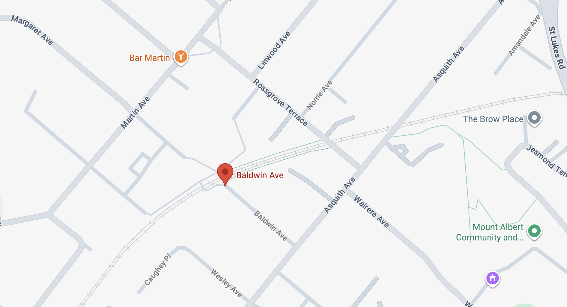
The Baldwin / Rossgrove/ Asquith cluster: an abundance of walk/ bike access points and two vehicle crossings.

The Asquith Ave level crossing (image via Google Streetview).
Consultation is now open to give feedback on the Western rail level crossing work. Greater Auckland will be taking a closer look at the various proposals in a post next week – stay tuned for more!
Have your say on options to replace rail level crossings between Kingsland and Mount Albert.
Share your feedback through our online survey or at a community event near you by 28 September 2026.
You can learn more about each crossing, the options we are considering and the options that are not being progressed on each crossing webpage:
- George Street, Kingsland
- Morningside Drive, Morningside
- Asquith Avenue, Rossgrove Terrace, Baldwin Avenue Station, Mount Albert
- Woodward Road, Mount Albert
You can find more information here. The consultation includes these in-person events:
- Dear Jane Cafe, 39 Martin Avenue, Mt Albert: Saturday 5 September, 9am to 11am
- Crave Cafe, 6 Morningside Drive, Morningside: Tuesday 8 September, 8am to 10am
- Mt Albert Community and Leisure Centre (includes focus group sessions), 773 New North Road, Mt Albert: Wednesday 23 September, 4pm to 8pm
- Auckland Irish Club (includes focus group sessions), Fowlds Park, Rocky Nook Avenue, Morningside: Saturday 26 September, 9am to 12pm
- Urbanaut, 597 New North Road, Kingsland: Sunday 27 September, 12pm to 2pm

 Processing...
I am very disappointed that the options considered for the George Street level crossing did not include the very obvious connection with replacing the Dominion Road/New North Road interchange with an at grade intersection. This would allow a direct connection between these two major roads – following which the George Street crossing could be closed. This has been discussed for years so I find it strange that the concept has not been evaluated by the level crossing team.
Don’t find that too strange. Surely the costs would be enormously grater. While the benefits would also be greater, a lot of benefits would be unrelated to the project, and (unless somebody brings cash to the table from the outside, like a developer) would not be monetary.
In other words, massive cost and scope creep would ensue. Our government is currently putting the thumbscrews on Councils to really tighten spending too, so where’s the money going to come from? A recipe for a study / business case with nothing happening afterwards. I think this makes sense to not be in scope as an option, or even serious short list.
Scope creep. Vs the very easy close to road traffic and replace with an active modes bridge. Sure they could use the budget to redevelop vast swathes of Auckland and use the development proceeds to pay for the crossing removals but it’s not realistic.
Only realistic if you’re fully grade separating a motorway like SH16 apparently
That wasn’t paid by development tho. And in fact as I understand it, our business case / BCR rules prevent taking into account any redevelopment benefits / cost reimbursements. Presumably it was originally intended to avoid letting people game the BCRs, but saying “oh yeah, we will redevelop the leftover land, and everything will pay for itself” and then the whole thing falling over due to a property downturn or similar. But it does sometimes lead to rather weird outcomes, where millions are paid for a property & booked as costs, even though 90% of the site afterwards isn’t needed and can be re-used.
Please read the options for George St, then submit your comments.
That would be a prime example of scope creep lol.
The Dominion Rd/New North Rd situation is a huge project of its own and shouldn’t be thrown on the Level Crossings team. Anyway, I assume George St will be closed anyway and replaced with a pedestrian bridge.
What is the actual increased projection of frequency of trains at peak and off peak times?
Go here: https://www.nzherald.co.nz/nz/auckland/city-rail-link-opening-new-train-lines-stations-and-routes-explained/G4XLIWPV6ZHOBGSJQQS2YLFTYQ/
Unrelated but does anyone know the approximate cost of tunnel lowering in NZ? The North Auckland Line had 13 tunnels lowered so we must have a pretty good idea of how to do it
This whole discussion is premised on the government or Auckland Council using a compulsory acquisition model. This model of infrastructure provision has an inherent bias towards doing the minimal amount of acquisition because as the authors outline acquisition is expensive. What the authors don’t say but imply – minimising the amount of acquisition is also due to being unable to capture any of the economic gains from providing a more comprehensive solution with better tunnels, better bridges, and a better local road network that is better sub-divided into developable plots so that more housing, more businesses, and more people can access the MRT train station. Also not stated but a further problem with compulsory land acquisition through urban areas is it is massively politically controversial – as some property owners and residents gain little and incur significant disruption while for others it is the opposite. It is virtually impossible to devise a fair compensation package.
There is another infrastructure provision model that doesn’t suffer from these setbacks. It is called land readjustment. The legislation has been adopted from many countries over the last century – but it seems to be the most advanced in Japan where 30% of urbanisation can be traced back to a land readjustment scheme of some variety.
There is a brilliant article explaining the land readjustment concept and why it works so well compared to the alternatives by Anya Martin writing for Works in Progress – titled “How to redraw a city”. https://worksinprogress.co/issue/how-to-redraw-a-city/
Decision makers for the Auckland level crossing project should consider given a fixed budget – say $3bn over a fixed timeframe – say two decades. what would the outcomes be using the compulsory acquisition model versus the land readjustment model (assuming NZ enacted the legislation that Japan uses and assuming the RMA NPS-UD allowing significant upzoning in the 10-minute walking catchment of MRT remains). The overseas experience indicates land readjustment provides the best long-term benefits to social cohesion, politically, and economically.
If the Crown is allowed to ‘capture’ the uplifted value of land then it should also be obliged to ‘release’ (compensate) the owners of properties that become less valuable as a result of infrastructural development.
Very interesting article, thanks for sharing.
No worries Phil.
Here is two more interesting articles on related topics.
https://www.thepost.co.nz/nz-news/360983294/superpower-could-unlock-billions-kiwirail-or-another-railway-company
https://www.nzherald.co.nz/business/business-reports/infrastructure-report/infrastructure-investment-land-assembly-needed-to-unlock-growth-precincts/premium/WPEOGBHFZBHRJOIPKJ65G2N5XU/
Both articles illustrate that infrastructure is not about the length of pipe, road, track or wire. It is about the housing, employment, businesses and other opportunities that infrastructure unlocks.
also disappointed there’s no mention of grade-separating the pedestrian level crossing at Lloyd Avenue
The Mt Albert bridge is right there
200m is a nothing in a car, but a major diversion for many when walking or riding.
Crossing frequency is similar to city block size as a limit to walkability.
They closed it years ago and I think there are 0 plans to do anything unless the local board does it. And cost/benefit doesn’t stack up unless you can get a ped bridge for ~$300k or less.
That crossing was removed in 2024, there is nothing to grade-seperate.
From experience living in Melbourne, road overbridges result in the worst urban outcomes of all options (by far). Auckland does have more difficult geography (nor is it as flush with cash) but it’s very disappointing to see that road-over-rail is the default option that AT are grasping for here in all cases. I’m sure the residents of Woodward and Asquith Aves etc. will vote for road bridges to maintain access, but I’m not sure that they’ll really be cognisant of how hulking those structures will end up being (without any public realm benefits either)
I’m also choosing to believe that the construction times quoted include design time. Four years for the average road bridge is still an age (especially if that means there will be no increase in services out west for at least that long) but if they mean there will be spades-in-the-ground on and off for half-a-decade per crossing it would be abysmal.
Looking at the topography of Asquith Avenue, I have no idea where a road bridge could be put. Yes, resident. No, not voting for that.
With the dip in Asquith Ave right after the crossing you’d think that would be a prime spot for an underpass, and lower the whole Rossgrove/Asquith intersection so Rossgrove has an underpass too.
Inner west are all pretty simple, close the road crossings and build ped bridges bar Woodward (which needs a road as Carrington/NNR doesn’t have the spare traffic capacity). I was surprised they were going with knocking a road between Asquith/Rossgrove rather than just using a tiny bit of the space in the rail corridor for a pedestrian path, feels like that’ll be vastly more expensive as involves land acquisition vs no cost bar a fence + the ped bridge they’d be building anyway.
I’m still surprised how long it’s taking, I kind of thought it’d be shovels in the ground a few months ago for George St while they sorted out the specifics of the others.
I think AT/KR are going to close a bunch of road crossings regardless of the consultation, as they can’t justify spending vast sums on a couple of road bridges where there are easy road alternatives nor do they have vast sums available. My hope is they don’t do the Kingdon/Lloyd Ave approach of closing with 0 active mode alternatives, as although driving is pretty easy to detour around, walking is a nightmare.
i’d say Morningside Dr also justifies keeping a road crossing there, especially since it carries the 22N/22R frequent bus route and connects Morningside station to St Lukes mall
I think the 22N/R should just go down NNR, and ignore St Lukes entirely. The 22 went to St Lukes in the past when there wasn’t the same alternatives to get to St Lukes from NNR. Now there is both the 65 and Outerlink which both are a relatively easy transfer @St Lukes Rd. For local trips they can extend the 20 loop a little bit so there is no loss of coverage – as the 20 terminates around there anyway and does a bit of a loop.
Obviously with infinite budget everything would be crossings for every mode, but we’ve seen how much road crossings seem to blow out, and Sainsbury exists to the west and Sandringham to the east. Worst case scenario it adds 4 minutes driving (from one side of the crossing to the other) if going west via Sainsbury or 6 minutes driving if going east via Sandringham, but most people aren’t driving from directly on one side to the other (and if they are they should just walk rather than drive for less than a minute as it would take longer to turn on the car and park than walking), so the total time added is far lower.
Regardless of whether they pick road/pedestrian for there – unlike every other bridge it needs to be specced for event crowds which will add a bunch of cost.
It’s interesting there was no consideration for retaining access when removing pedestrian only level crossings recently. In that case the entire consultation was about improving alternatives, not contesting the removal of existing crossings. Yet for motor vehicles it seems retaining access is the default.
My thoughts on Glen Eden (submitted as email back in May:
https://www.robincapper.net/at-level-crossing-survey-glen-eden-level-crossing-closure/
I thought the plan re Mt Albert was to add a 3rd track west of the station to turn trains around in the short term then the first stage of Avondale – Southdown would allow train frequency to be split down the branch. Or if Avondale – Southdown doesn’t get started higher frequency until New Lynn then Henderson, but this a process that will probably take decades.
As the first few 2 stages (roughly a stage per station) to Dom Rd are relatively simple (only complexity is the grade seperated junction with the Western Line and NNR crossing).
I really dont understand the urgency to remove level crossings. I have family living in the suburbs of Tokyo where there are level crossings every few blocks with trains running both ways at 5 minute intervals all day. It doesnt seem to be a problem!
from the pedestrian standpoint it’s safety. i remember a bunch of deaths and near misses in the news last decade with all the pedestrian level crossings on the Western Line, some of them involving disabled people in wheelchairs or mobility scooters.
from the car standpoint, it’s probably the Church of Traffic Engineers at AT not wanting to hold up cars nor remove the most direct route for certain journeys
Probably because Japanese people know how to give away a trains.
In general (does depend on topography) rail overhead with road underpass > than road overpass.
This is due to the rail OLE needing greater clearance. It’s easier to raise up a track slightly and trench a road underneath. Requires a narrower bridge too.
As for Morningside, they should purchase the property to the west of the crossing and construct through that to minimise disruption. They can then redevelop the existing crossing land to regain that expense.
I still think they could just trial road crossing closures for say 3 months – just to see what happens and then make decisions based on the impact.